Related Research Articles

The Laramide orogeny was a time period of mountain building in western North America, which started in the Late Cretaceous, 80 to 70 million years ago, and ended 55 to 35 million years ago. The exact duration and ages of beginning and end of the orogeny are in dispute. The Laramide orogeny occurred in a series of pulses, with quiescent phases intervening. The major feature that was created by this orogeny was deep-seated, thick-skinned deformation, with evidence of this orogeny found from Canada to northern Mexico, with the easternmost extent of the mountain-building represented by the Black Hills of South Dakota. The phenomenon is named for the Laramie Mountains of eastern Wyoming. The Laramide orogeny is sometimes confused with the Sevier orogeny, which partially overlapped in time and space.

The Pyrenees are a 430-kilometre-long, roughly east–west striking, intracontinental mountain chain that divide France, Spain, and Andorra. The belt has an extended, polycyclic geological evolution dating back to the Precambrian. The chain's present configuration is due to the collision between the microcontinent Iberia and the southwestern promontory of the European Plate. The two continents were approaching each other since the onset of the Upper Cretaceous (Albian/Cenomanian) about 100 million years ago and were consequently colliding during the Paleogene (Eocene/Oligocene) 55 to 25 million years ago. After its uplift, the chain experienced intense erosion and isostatic readjustments. A cross-section through the chain shows an asymmetric flower-like structure with steeper dips on the French side. The Pyrenees are not solely the result of compressional forces, but also show an important sinistral shearing.

The geology of North America is a subject of regional geology and covers the North American continent, the third-largest in the world. Geologic units and processes are investigated on a large scale to reach a synthesized picture of the geological development of the continent.

The Persian Gulf Basin is found between the Eurasian and the Arabian Plate. The Persian Gulf is described as a shallow marginal sea of the Indian Ocean that is located between the south western side of Iran and the Arabian Peninsula and south and southeastern side of Oman and the United Arab Emirates. Other countries that border the Persian Gulf basin include; Saudi Arabia, Qatar, Kuwait, Bahrain and Iraq. The Persian Gulf extends a distance of 1,000 km (620 mi) with an area of 240,000 km2 (93,000 sq mi). The Persian Gulf basin is a wedge-shaped foreland basin which lies beneath the western Zagros thrust and was created as a result of the collision between the Arabian and Eurasian plates.

The North Sea basin is located in northern Europe and lies between the United Kingdom, and Norway just north of The Netherlands and can be divided into many sub-basins. The Southern North Sea basin is the largest gas producing basin in the UK continental shelf, with production coming from the lower Permian sandstones which are sealed by the upper Zechstein salt. The evolution of the North Sea basin occurred through multiple stages throughout the geologic timeline. First the creation of the Sub-Cambrian peneplain, followed by the Caledonian Orogeny in the late Silurian and early Devonian. Rift phases occurred in the late Paleozoic and early Mesozoic which allowed the opening of the northeastern Atlantic. Differential uplift occurred in the late Paleogene and Neogene. The geology of the Southern North Sea basin has a complex history of basinal subsidence that had occurred in the Paleozoic, Mesozoic, and Cenozoic. Uplift events occurred which were then followed by crustal extension which allowed rocks to become folded and faulted late in the Paleozoic. Tectonic movements allowed for halokinesis to occur with more uplift in the Mesozoic followed by a major phase of inversion occurred in the Cenozoic affecting many basins in northwestern Europe. The overall saucer-shaped geometry of the southern North Sea Basin indicates that the major faults have not been actively controlling sediment distribution.

The geology of Germany is heavily influenced by several phases of orogeny in the Paleozoic and the Cenozoic, by sedimentation in shelf seas and epicontinental seas and on plains in the Permian and Mesozoic as well as by the Quaternary glaciations.
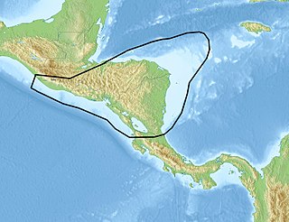
The Chortis Block is a 400–600 km (250–370 mi)-wide continental fragment in Central America located in the northwest corner of the oceanic Caribbean Plate.
The geology of Somalia is built on more than 700 million year old igneous and metamorphic crystalline basement rock, which outcrops at some places in northern Somalia. These ancient units are covered in thick layers of sedimentary rock formed in the last 200 million years and influenced by the rifting apart of the Somali Plate and the Arabian Plate. The geology of Somaliland, the de facto independent country recognized as part of Somalia, is to some degree better studied than that of Somalia as a whole. Instability related to the Somali Civil War and previous political upheaval has limited geologic research in places while heightening the importance of groundwater resources for vulnerable populations.

The geology of Somaliland is very closely related to the geology of Somalia. Somaliland is a de facto independent country within the boundaries that the international community recognizes as Somalia. Because it encompasses the former territory of British Somaliland, the region is historically better researched than former Italian Somaliland. Somaliland is built on more than 700 million year old igneous and metamorphic crystalline basement rock.. These ancient units are covered in thick layers of sedimentary rock formed in the last 200 million years and influenced by the rifting apart of the Somali Plate and the Arabian Plate.
The geology of Morocco formed beginning up to two billion years ago, in the Paleoproterozoic and potentially even earlier. It was affected by the Pan-African orogeny, although the later Hercynian orogeny produced fewer changes and left the Maseta Domain, a large area of remnant Paleozoic massifs. During the Paleozoic, extensive sedimentary deposits preserved marine fossils. Throughout the Mesozoic, the rifting apart of Pangaea to form the Atlantic Ocean created basins and fault blocks, which were blanketed in terrestrial and marine sediments—particularly as a major marine transgression flooded much of the region. In the Cenozoic, a microcontinent covered in sedimentary rocks from the Triassic and Cretaceous collided with northern Morocco, forming the Rif region. Morocco has extensive phosphate and salt reserves, as well as resources such as lead, zinc, copper and silver.

The geology of Sudan formed primarily in the Precambrian, as igneous and metamorphic crystalline basement rock. Ancient terranes and inliers were intruded with granites, granitoids as well as volcanic rocks. Units of all types were deformed, reactivated, intruded and metamorphosed during the Proterozoic Pan-African orogeny. Dramatic sheet flow erosion prevented almost any sedimentary rocks from forming during the Paleozoic and Mesozoic. From the Mesozoic into the Cenozoic the formation of the Red Sea depression and complex faulting led to massive sediment deposition in some locations and regional volcanism. Sudan has petroleum, chromite, salt, gold, limestone and other natural resources.
The geology of the U.S. Virgin Islands includes mafic volcanic rocks, with complex mineralogy that first began to erupt in the Mesozoic overlain and interspersed with carbonate and conglomerate units.
The geology of Utah, in the western United States, includes rocks formed at the edge of the proto-North American continent during the Precambrian. A shallow marine sedimentary environment covered the region for much of the Paleozoic and Mesozoic, followed by dryland conditions, volcanism, and the formation of the basin and range terrain in the Cenozoic.

The geology of North Korea has been studied by the Central Geological Survey of Mineral Resources, rare international research and by inference from South Korea's geology.
The geology of Iraq includes thick sequences of marine and continental sedimentary rocks over poorly understood basement rock, at the junction of the Arabian Plate, the Anatolian Plate, and the Iranian Plate.

The geology of Italy includes mountain ranges such as the Alps and the Apennines formed from the uplift of igneous and primarily marine sedimentary rocks all formed since the Paleozoic. Some active volcanoes are located in Insular Italy.

The geology of Peru includes ancient Proterozoic rocks, Paleozoic and Mesozoic volcanic and sedimentary rocks, and numerous basins and the Andes Mountains formed in the Cenozoic.
The geology of Yukon includes sections of ancient Precambrian Proterozoic rock from the western edge of the proto-North American continent Laurentia, with several different island arc terranes added through the Paleozoic, Mesozoic and Cenozoic, driving volcanism, pluton formation and sedimentation.
The geology of California is highly complex, with numerous mountain ranges, substantial faulting and tectonic activity, rich natural resources and a history of both ancient and comparatively recent intense geological activity. The area formed as a series of small island arcs, deep-ocean sediments and mafic oceanic crust accreted to the western edge of North America, producing a series of deep basins and high mountain ranges.

The Maya Block, also known as the Maya Terrane, Yucatan Block, or Yucatan–Chiapas Block, is a physiographic or geomorphic region and tectonic or crustal block in the southernmost portion of the North American Plate.
References
- ↑ "Field Guide to Guatemalan Geology – Stanford Alpine Project 2004-2005" (PDF). 2005-12-18. Retrieved 2018-11-10.
- ↑ Bishop, William F. (2008). "Petroleum Geology of Northern Central America". Journal of Petroleum Geology. 3: 3–59. doi:10.1111/j.1747-5457.1980.tb01003.x.
- ↑ Rosenfeld, J. H. (1981). "Geology of the western Sierra de Santa Cruz, Guatemala, Central America: An ophi". Bibcode:1981PhDT.........7R.
{{cite journal}}: Cite journal requires|journal=(help) - ↑ Newhall, Christopher G. (1987). "Geology of the Lake Atitlán Region, Western Guatemala". Journal of Volcanology and Geothermal Research. 33 (1): 23–55. Bibcode:1987JVGR...33...23N. doi:10.1016/0377-0273(87)90053-9.
- ↑ Anderson, T.H.; et al. (1973). "Geology of the Western Altos Cuchumatanes, Northwestern Guatemala". GSA Bulletin. GeoScienceWorld. 84 (3): 805–826. doi:10.1130/0016-7606(1973)84<805:GOTWAC>2.0.CO;2.