Related Research Articles
This article lists extreme locations on Earth that hold geographical records or are otherwise known for their geophysical or meteorological superlatives. All of these locations are Earth-wide extremes; extremes of individual continents or countries are not listed.

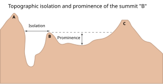
In topography, prominence or relative height measures the height of a mountain or hill's summit relative to the lowest contour line encircling it but containing no higher summit within it. It is a measure of the independence of a summit. The key col ("saddle") around the peak is a unique point on this contour line and the parent peak is some higher mountain, selected according to various criteria.

This is a list of the extreme points of Ireland – the points that are farthest north, south, east or west in Ireland. It includes the Republic of Ireland and Northern Ireland.
This is a list of the extreme points of Europe: the geographical points that are higher or farther north, south, east or west than any other location in Europe. Some of these positions are open to debate, as the definition of Europe is diverse.
A list of highest points typically contains the name, elevation, and location of the highest point in each of a set of geographical regions. Such a list is important in the sport of highpointing. A partial list of highpoint lists is below:

Tunnsjøen (Norwegian) or Dåtnejaevrie (Southern Sami) is a lake in Røyrvik Municipality and Lierne Municipality in Trøndelag county, Norway. The 100.18-square-kilometre (38.68 sq mi) lake lies just south of the large lake Limingen, and just west of the border with Sweden. It is 358 m (1,175 ft) above sea level and has a volume of 8.816 km3 (2.115 cu mi). The deepest part of the lake is 222 m (728 ft) deep. It is the seventh largest lake in Norway.

The topographic isolation of a summit is the minimum distance to a point of equal elevation, representing a radius of dominance in which the peak is the highest point. It can be calculated for small hills and islands as well as for major mountain peaks and can even be calculated for submarine summits. Mount Everest, the highest point on Earth, has an undefined isolation, since there are no higher points to reference.

This article comprises three sortable tables of major mountain peaks of Canada.
Mountains are listed according to various criteria:
References
- ↑ Allen, C.D. (2017). Landscapes and Landforms of the Lesser Antilles. Springer International Publishing. ISBN 9783319557878 . Retrieved 2018-11-09.