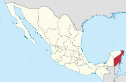
Quintana Roo is located on the eastern part of the Yucatán Peninsula and is bordered by the states of Campeche to the west and Yucatán to the northwest, and by the Orange Walk and Corozal districts of Belize, along with an offshore borderline with Belize District to the south. As Mexico's easternmost state, Quintana Roo has a coastline to the east with the Caribbean Sea and to the north with the Gulf of Mexico. The state previously covered 44,705 square kilometers (17,261sqmi) and shared a small border with Guatemala in the southwest of the state.[9][10] However, in 2013, Mexico's Supreme Court of Justice of the Nation resolved the boundary dispute between Quintana Roo, Campeche, and Yucatán stemming from the creation of the Calakmul municipality by Campeche in 1997, siding with Campeche and thereby benefiting Yucatán.[11]
Quintana Roo is home to the city of Cancún, the islands of Cozumel and Isla Mujeres, and the towns of Bacalar, Playa del Carmen and Akumal, as well as the ancient Maya ruins of Chacchoben, Cobá, Kohunlich, Muyil, Tulum, Xel-Há, San Gervasio and Xcaret. The Sian Ka'anbiosphere reserve is also located in the state. The statewide population is expanding at a rapid rate due to the construction of hotels and the demand for workers. Many migrants come from Yucatán, Campeche, Tabasco, and Veracruz. The state is frequently hit by severe hurricanes due to its exposed location, the most recent and severe being Hurricane Dean in 2007, which made landfall with sustained winds of 280km/h (170mph), with gusts up to 320km/h (200mph).
The area that makes up present-day Quintana Roo was long part of Yucatán, sharing its history. With the Caste War of Yucatán, which started in the 1840s, all non-natives were driven from the region. The independent Maya nation of Chan Santa Cruz was based on what is now the town of Felipe Carrillo Puerto. For decades, it maintained considerable independence, having separate trade and treaty relationships with British Honduras, now Belize.
The Territory of Quintana Roo was created by decree of President Porfirio Díaz on November 24, 1902. It was named after an early patriot of the Mexican Republic, Andrés Quintana Roo. The Mexican Federal Army succeeded in subjugating most of the indigenous Maya population of the region during the 1910s. In 1913, the area was again declared to be legally part of the state of Yucatán, but was again declared a separate territory in 1915. The territory of Quintana Roo was granted statehood within the United Mexican States on October 8, 1974.[12]
In the last quarter of the 20th century and continuing into the 21st, Quintana Roo developed rapidly, with tourism being a driving force, notably with the development of Cancún. As result of this development, the northern part of Quintana Roo has been increasingly touristified.[13] By contrast the south has continued with a traditional economy of forestry and wood extraction.[13]
Archaeological findings
Ancient human remains have been discovered in a system of submerged caves and sinkholes in the Tulum area of Quintana Roo. To date, a total of nine skeletons have been found in these caves, including one of the oldest human skeletons found on the American continent. In 2016, underwater archaeological exploration of a cave known as Chan Hol found a skeleton of a female who lived in the region at least 9,900 years ago, during the Paleo-Indian period. Dating revealed that the skeleton was probably about 30 years old at the time of death. Three different scars on the skull of the woman showed that she was hit with something hard and her skull bones were broken. Her skull also had crater-like deformations and tissue deformities that appeared to be caused by a bacterial relative of syphilis.[14]
According to study lead researcher Wolfgang Stinnesbeck, "It really looks as if this woman had a very hard time and an extremely unhappy end of her life. Obviously, this is speculative, but given the traumas and the pathological deformations on her skull, it appears a likely scenario that she may have been expelled from her group and was killed in the cave, or was left in the cave to die there".[15]
The skeleton found by the 2016 exploration was 140m (150yd) away from a site where a previous expedition found human remains known as Chan Hol 2. Although archaeologists assumed the 2016 expedition had rediscovered Chan Hol 2, Stinnesbeck concluded that the two skeletons represent different individuals.[16]
Due to their distinctive features, study co-researcher Samuel Rennie suggested the existence of at least two morphologically diverse groups of people living separately in Mexico during the transition from Pleistocene to Holocene.[15]
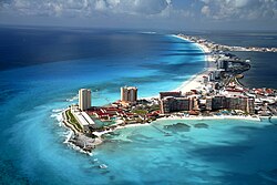
The city of Cancún is a major tourist resort in Quintana Roo, especially the Hotel Zone.
This section should include a summary of, or be summarized in, another article. See Wikipedia:Summary style for information on how to incorporate it into this article's main text, or the main text of another article.(February 2021)
Climate
According to the Köppen climate classification, much of the state has a tropical wet and dry climate (Aw) while the island of Cozumel has a tropical monsoon climate (Am).[17] The mean annual temperature is 26°C (78.8°F).[18] The hottest months are April and August, in which the average high is 33°C (91.4°F), while January is the coldest month with an average low of 17°C (62.6°F).[18] Extreme temperatures can range from a low of 10°C (50.0°F) in the coldest months to 36°C (96.8°F) in the hottest months.[17] Quintana Roo averages 1,300mm (51in) of precipitation per year, which falls throughout the year, though June to October are the wetter months.[18] Hurricanes can occasionally hit the coastal areas during the hurricane season, particularly from September to November.[17] 2020 was a historic year for hurricanes in Quintana Roo, with a record-breaking 31 tropical systems formed, of which four affected the state.[19]
The Yucatán Peninsula is one of the most forested areas of the world in terms of biotic mass per hectare. However, anthropological, biological and governmental experts have determined that Quintana Roo is 'facing a faunal crisis'.[20] Many medium to large game animals are disappearing due to hunting and habitat loss. While its population is relatively small, Quintana Roo is experiencing both a population influx and an increase in tourism.[20][21] This only increases the pressure on the plants and animals native to the area.
From 1996 to 2003, the USAID-supported programme Conserving Critical Coastal Ecosystems in Mexico operated in the southern portion of Quintana Roo with partners including Conservation International Mexico, combining site-based coastal management initiatives with policy and planning work for tourism and shoreline use in the Costa Maya region (including work in Xcalak and Chetumal Bay).[22]
Ecosystems and animals
There are four generalized ecosystems in Quintana Roo—tropical forests, or jungle; savanna, mangrove forests, and coral reefs. One of the byproducts of traditional and large-scale agriculture is the creation of additional habitats, such as second growth forests and fields/pastures.[23] Tourism has caused Quintana Roo to become famous around the world in the last thirty or so years for its beaches, coastline, and cenote sinkholes.[24][25] Biological experts consider the coastline of Quintana Roo one of the best manatee habitats worldwide.[26]Queen conchs are also noted for their inhabitation of coastal territory.[26] The wide variety of biotic organisms such as these has decreased drastically in the last fifteen years.[27][28]
Birds
Also affected by the loss of habitat due to both agriculture and development, birds are one of the region's most varied animal assets.[20] Hundreds of species reside in Quintana Roo permanently, with hundreds of others either wintering there or using it as a stopover on the long journey into South America.[26] As a result, many birders come to the area annually in search of the rare and unexpected.[20]
Aerial view of Cancún's Hotel ZoneBeach of Contoy IslandBeach of Punta Sur at south at the Cozumel Island
Quintana Roo's tourist boom began in the 1970s.[20]Tourism resulted in the development of coastal hotels and resorts, in addition to ecotourism inland and in coastal regions, which have increased the development of the region as well as the gross domestic product.[27] Quintana Roo ranks sixth among Mexican states according to the United Nations Human Development index (HDI).[21]
Projections for the tourism economy of Quintana Roo have been optimistic, based on multiple attractions, from the Maya ruins to the lush forests and beautiful beaches. However, long-term problems include the effect on the local environment, economic stresses of development and population,[28] and "economicmarginalization" of the Maya natives.[27]
Newspapers of Quintana Roo include: Diario de Quintana Roo, Diario Respuesta, El Periódico de Quintana Roo, El Quintanarroense, Novedades de Quintana Roo, and Por Esto![32][33]
On February 1, 2015, Quintana Roo officially adopted a new time zone, Southeastern, which is five hours behind Coordinated Universal Time (UTC−05:00). Quintana Roo does not observe daylight saving time, so Southeastern Time is constant throughout the year. Southeastern Time (ST) is the same as Eastern Standard Time (EST) and Central Daylight Time (CDT). This means that in the winter, Quintana Roo has the same time as regions observing EST, such as the eastern U.S., eastern Canada, Cuba, and Jamaica; and in the summer, Quintana Roo has the same time as regions observing CDT, such as central Mexico.[39][40][41][42][43][44]
Quintana Roo changed to Southeastern Time for economic reasons, including:
Allowing tourists in areas such as Cancún, Cozumel, and Playa del Carmen to spend more time (and money) at beaches, restaurants, historic sites, and other venues.
Reducing electricity usage by hotels, restaurants, and other facilities.
Before Quintana Roo adopted the Southeastern time zone (officially referred to as zona sureste in Mexico), it had been part of the Central time zone (zona centro).
123"MEDIO FÍSICO". Enciclopedia de Los Municipios y Delegaciones de México (in Spanish). Instituto para el Federalismo y el Desarrollo Municipal. Archived from the original on February 23, 2015. Retrieved February 1, 2016.
123"Clima". Información por entidad (in Spanish). Instituto Nacional de Estadística y Geografía. Archived from the original on January 20, 2016. Retrieved February 1, 2016.
123Schlesinger, Victoria. 2001. Animals and Plants of the Ancient Maya: A Guide. University of Texas Press. Austin, Texas.
123Daltabuit, Magali and Oriol Pi-Sunyer. 1990. Tourism Development in Quintana Roo, Mexico. Cultural Survival Quarterly 14.2, 9-13.
12Juarez, Ana M. 2002. "Ecological Degradation, Global Tourism, and Inequality: Maya Interpretations of the Changing Environment in Quintana Roo, Mexico. Human Organization 61.2, 113-124.
Dumond, Don E.1985 The Talking Crosses of Yucatán: A New Look at their History. Ethnohistory 32(4):291–308.
Freidel, David., Schele, Linda., et al. 1993 Maya Cosmos: Three thousand years on the Shaman's Path. New York: W. Morrow
Harrison, Peter D. 1985 Some Aspects of Preconquest Settlement in Southern Quintana Roo, Mexico. Lowland Maya Settlement Patterns edited by Wendy Ashmore Albuquerque: University of New Mexico Press, A School of American Research Book.
Villa Rojas, Alfonso. 1945 The Maya of East Central Quintana Roo: The Pagan-Christian Religious Complex. Washington, D.C.: Carnegie Institution.
Further reading
Anderson, E. N. and Felix Medina Tzuc. Animals and the Maya in Southeast Mexico. University of Arizona Press. Tucson, Arizona. 2005.
Brannon, Jeffery T. and Gilbert M. Joseph. Eds. 1991 Land, labor & capital in modern Yucatán: essays in regional history and political economy. Tuscaloosa: University of Alabama Press.
Barton Bray, David, Marcelo Carreon, Leticia Merino, and Victoria Santos. "On the Road to Sustainable Forestry: The Maya of Quintana Roo are Striving to Combine Economic Efficiency, Ecological Sustainability, and a Democratic Society." Cultural Survival Quarterly 17.1, 38–41. 1993.
Daltabuit, Magali and Oriol Pi-Sunyer. 1990. Tourism Development in Quintana Roo, Mexico. Cultural Survival Quarterly 14.2, 9-13. Cultural Survival
Dumond, Don E. 1997 The Machete and the Cross. Campesino Rebellion in Yucatán. Lincoln and London: University of Nebraska Press.
Encyclopædia Britannica 2008. Quintana Roo. Encyclopædia Britannica, Inc. Accessed 2008-02-21.
Forero, Oscar A. and Michael R. Redclift. "The Role of the Mexican State in the Development of Chicle Extraction in Yucatán, and the Continuing Importance of Coyotaje." Journal of Latin American Studies 38.1, 65–93. 2006.
Gabbert, Wolfgang. Becoming Maya—Ethnicity and Social Inequality in Yucatán Since 1500. University of Arizona Press. Tucson, Arizona. 2004.
Hervik, Peter. Mayan People Within and Beyond Boundaries—Social Categories and Lived Identity in Yucatán. Harwood Academic Publishers. Amsterdam, the Netherlands. 1999.
Jones, Grant D. Maya Resistance to Spanish Rule—Time and History on a Colonial Frontier. University of New Mexico Press. Albuquerque, New Mexico. 1989.
Juarez, Ana M. 2002. "Ecological Degradation, Global Tourism, and Inequality: Maya Interpretations of the Changing Environment in Quintana Roo, Mexico". Human Organization 61.2, 113–124.
Morely, Sylvanus Griswold. The Ancient Maya. Stanford University Press. Stanford, California. 1947.
Morely, Sylvanus Griswold and George W. Brainerd. The Ancient Maya, 3rd ed. Stanford University Press. Stanford, California. 1956.
Pi-Sunyer, Oriol and R. Brooke Thomas. 1997. Tourism, Environmentalism, and Cultural Survival in Quintana Roo. "In" Life and Death Matters: Human Rights at the End of the Millennium. Barbara R. Johnston, ed. p.187-212. Walnut Creek, California. Altamira Press.
Roys, Ralph L. The Political Geography of the Yucatán Maya. Carnegie Institution of Washington Publication 613. Washington, D. C. 1957.
Rugeley, Terry. 2004 "Yaxcabá and the caste war of Yucatán: An Archaeological Perspective" In Alexander, Rani T. ed. Yaxcabá and the caste war of Yucatán Albuquerque: University of New Mexico Press
Schlesinger, Victoria. Animals and Plants of the Ancient Maya: A Guide. University of Texas Press. Austin, Texas. 2001.
Sharer, Robert J. The Ancient Maya, 4th ed. Stanford University Press. Stanford, California. 1983.
Villa Rojas, Alfonso. The Maya of East Central Quintana Roo. Carnegie Institute of Washington Publication 559. Washington, D. C. 1945.
Young, Peter A, ed. Secrets of the Maya. Hatherleigh Press. Long Island City, New York. 2003
This page is based on this Wikipedia article Text is available under the CC BY-SA 4.0 license; additional terms may apply. Images, videos and audio are available under their respective licenses.