
North America is a continent in the Northern and Western Hemispheres. North America is bordered to the north by the Arctic Ocean, to the east by the Atlantic Ocean, to the southeast by South America and the Caribbean Sea, and to the west and south by the Pacific Ocean. The region includes the Bahamas, Bermuda, Canada, the Caribbean, Central America, Clipperton Island, Greenland, Mexico, Saint Pierre and Miquelon, Turks and Caicos Islands, and the United States.

Sierra County is a county located in the U.S. state of New Mexico. As of the 2020 Census, the population was 11,576. Its county seat is Truth or Consequences.

Santa Fe County is a county located in the U.S. state of New Mexico. As of the 2020 census, the population was 154,823, making it New Mexico's third-most populous county, after Bernalillo County and Doña Ana County. Its county seat is Santa Fe, the state capital.
San Juan County is a county located in the U.S. state of New Mexico. As of the 2020 census, the population was 121,661 making it the fifth-most populous county in New Mexico. Its county seat is Aztec. The county was created in 1887.

Rio Arriba County is a county in the U.S. state of New Mexico. As of the 2020 census, the population was 40,363. Its county seat is Tierra Amarilla. Its northern border is the Colorado state line.

Mora County is a county in the U.S. state of New Mexico. As of the 2020 census, the population was 4,189. Its county seat is the census-designated place (CDP) Mora. The county has another CDP, Watrous, a village, Wagon Mound, and 12 smaller unincorporated settlements. Mora became a formal county in the US, in what was then the New Mexico Territory, on February 1, 1860. Ecclesiastically, the county is within the Roman Catholic Archdiocese of Santa Fe. County population peaked at approximately 14,000 circa 1920, declining to about 4,000 to 5,000 since the 1970s; the 2018 estimate was 4,506.

McKinley County is a county in the northwestern section of the U.S. state of New Mexico. As of the 2020 United States Census, its population was 72,902. Its county seat is Gallup. The county was created in 1901 and named for President William McKinley.
Bernalillo County is the most populous county in the U.S. state of New Mexico. As of the 2020 census, the population was 676,444. The county seat, Albuquerque, is the most populous city in New Mexico.

Costilla County is a county located in the U.S. state of Colorado. As of the 2020 census, the population was 3,499. The county seat is San Luis, the oldest continuously occupied town in Colorado.

Chilili is a census-designated place in Bernalillo County, New Mexico, United States. The population was 137 at the 2010 census. It is part of the Albuquerque Metropolitan Statistical Area.
Nayarit, officially the Estado Libre y Soberano de Nayarit, is one of the 31 states that, along with Mexico City, comprise the Federal Entities of Mexico. It is divided in 20 municipalities and its capital city is Tepic.
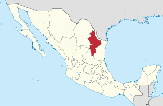
Nuevo León, officially the Free and Sovereign State of Nuevo León is a state in northeastern Mexico. The state borders the Mexican states of Tamaulipas, Coahuila, Zacatecas, and San Luis Potosi, and has an extremely narrow international border with the U.S. state of Texas. Covering 64,156 square kilometers and with a population of 5.78 million people, Nuevo León is the thirteenth-largest federal entity by area and the seventh-most populous as of 2020.

Campeche is a state on the Yucatán Peninsula in Mexico that is divided into thirteen municipalities. According to the 2020 Mexican census, Campeche is the third least populous state with 928,363 inhabitants and the 17th largest by land area spanning 57,693.59 square kilometres (22,275.62 sq mi).

Mexicans are the citizens and nationals of the United Mexican States. The Mexican people have varied origins with the most spoken language being Spanish, but many also speak languages from 68 different Indigenous linguistic groups and other languages brought to Mexico by expatriates or recent immigration. In 2020, 19.4% of Mexico's population identified as Indigenous. There are currently about 12 million Mexican nationals residing outside Mexico, with about 11.7 million living in the United States. The larger Mexican diaspora can also include individuals that trace ancestry to Mexico and self-identify as Mexican but are not necessarily Mexican by citizenship. The United States has the largest Mexican population in the world after Mexico at 37,186,361 in 2019.
Durango is a state in Northwest Mexico that is divided into 39 municipalities. According to the 2020 Mexican census, Durango is the 25th most populous state with 1,832,650 inhabitants, but the 4th largest by land area spanning 123,575.36 square kilometres (47,712.71 sq mi). Durango has a population density of 14.8/km2 (38.4/sq mi), making it Mexico's second-lowest dense state, after Baja California Sur.

Greater Mexico City is the conurbation around Mexico City, officially called the Metropolitan Area of the Valley of Mexico. It encompasses Mexico City itself and 60 adjacent municipalities of the State of Mexico and Hidalgo.
Mexican Colony is a census-designated place in Kern County, California. It is located 2 miles (3.2 km) south of Shafter, at an elevation of 331 feet (101 m). The population was 283 at the 2020 census.

Zinapécuaro de Figueroa is a town and the seat of the municipality of Zinapécuaro, in the central Mexican state of Michoacán.

Villa Jiménez is a town and the municipal seat of the municipality of Jiménez in the Mexican state of Michoacán.
