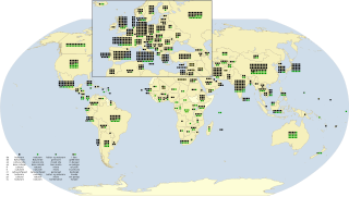
World Heritage Sites
† In danger
* Trans-border site
| Site | Image | Location | Criteria | Area ha (acre) | Year | Description | Refs |
|---|---|---|---|---|---|---|---|
| Alejandro de Humboldt National Park |  | Holguín and Guantánamo, 20°27′N75°0′W / 20.450°N 75.000°W | Natural: (ix), (x) | 69,341 (171,350); buffer zone 34,330 (84,800) | 2001 | The park exhibits a wide array of geology types. It contains many biological species, including 16 of Cuba's 28 endemic plant species, as well as animal species such as the endangered Cuban solenodon. | [3] [4] |
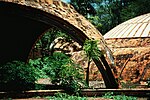
| Antigua Naval Dockyard and Related Archaeological Sites |  | English Harbour, Antigua, 17°00′30″N61°45′52″W / 17.00833°N 61.76444°W | Cultural: (ii), (iv) | 255 (630); buffer zone 3,873 (9,570) | 2016 | The site consists of a group of Georgian-style naval buildings and structures, set within a walled enclosure. The natural environment of this side of the island of Antigua, with its deep, narrow bays surrounded by highlands, offered shelter from hurricanes and was ideal for repairing ships. The construction of the Dockyard by the British navy would not have been possible without the labour of generations of enslaved Africans since the end of the 18th century. Its aim was to protect the interests of sugar cane planters at a time when European powers were competing for control of the Eastern Caribbean. | [5] |
| Archaeological Landscape of the First Coffee Plantations in the South-East of Cuba |  | Santiago de Cuba and Guantánamo, 20°00′21″N75°37′4″W / 20.00583°N 75.61778°W | Cultural: (iii), (iv) | 81,475 (201,330) | 2000 | During the 19th and early 20th centuries, eastern Cuba was primarily involved with coffea cultivation. The remnants of the plantations display the techniques used in the difficult terrain, as well as the economic and social significance of the plantation system in Cuba and the Caribbean. | [5] |
| Blue and John Crow Mountains |  | 18°04′39″N76°34′16″W / 18.077500°N 76.571111°W | Mixed: (iii), (vi), (x) | 26,252 (64,870); buffer zone 28,494 (70,410) | 2015 | The park covers roughly about 4.5% of Jamaica. | [6] |
| Brimstone Hill Fortress National Park |  | Saint Kitts, 17°20′49″N62°50′14″W / 17.34694°N 62.83722°W | Cultural: (iii), (iv) | — | 1999 | Built during the 17th and 18th centuries by African slaves in a period of European colonial expansion, the fortress is an exceptionally well preserved example of British military architecture in the Caribbean. | [7] |
| Colonial City of Santo Domingo |  | Distrito Nacional, 18°29′0″N69°55′0″W / 18.48333°N 69.91667°W | Cultural: (ii), (iv), (vi) | 93 (230) | 1990 | Santo Domingo was founded in 1498 shortly after the arrival of Christopher Columbus on the island and had the first cathedral, hospital, customs house and university built in the New World. Its grid patterned town plan became the model for other colonial towns in the Americas. | [8] |
| Desembarco del Granma National Park |  | Granma, 19°53′N77°38′W / 19.883°N 77.633°W | Natural: (vii), (viii) | 32,576 (80,500) | 1999 | The park features a unique karst topography with features such as terraces, cliffs, and waterfalls. | [9] [10] |
| Historic Area of Willemstad, Inner City and Harbour, Curaçao |  | Willemstad, 12°6′7″N68°54′8″W / 12.10194°N 68.90222°W | Cultural: (ii), (iv), (v) | 86 (210); buffer zone 87 (210) | 1997 | The architecture of the 17th-century Dutch trading settlement Willemstad combines styles from the Netherlands with Spanish and Portuguese colonial towns. | [11] |
| Historic Bridgetown and its Garrison |  | Bridgetown 13°5′48″N59°36′50″W / 13.09667°N 59.61389°W | Cultural: (ii), (iii), (iv) | 187 (460); buffer zone 321 (790) | 2011 | Bridgetown is an excellent example of a British colonial settlement built from the 17th to 19th century. Unlike Dutch and Spanish settlements of the area, the town is not laid out on a grid plan but follows a serpentine urban design. | [12] |
| Historic Centre of Camagüey |  | Camagüey, 21°22′43″N77°55′7″W / 21.37861°N 77.91861°W | Cultural: (iv), (v) | 54 (130); buffer zone 276 (680) | 2008 | Camagüey is among the first seven villages founded by the Spanish in Cuba, first settled in 1528. The irregular organization of the city is distinct from the typical, orderly construction of most other Spanish settlements. This maze-like style was influenced by medieval European ideas and traditional construction methods of early immigrant masons and construction workers. | [13] |
| La Fortaleza and San Juan National Historic Site in Puerto Rico |  | San Juan 18°28′0″N66°7′30″W / 18.46667°N 66.12500°W | Cultural: (vi) | 33 (82) | 1983 | A series of defensive structures built between the 16th and 20th centuries at a strategic point in the Caribbean Sea to protect the city and the Bay of San Juan. They represent a fine display of European military architecture adapted to harbour sites on the American continent. | [14] |
| Morne Trois Pitons National Park |  | south central part of the island, 15°16′N61°17′W / 15.267°N 61.283°W | Natural: (viii), (x) | 6,857 (16,940) | 1997 | [15] | |
| National History Park – Citadel, Sans Souci, Ramiers | 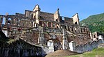 | Nord, 19°34′25″N72°14′39″W / 19.57361°N 72.24417°W | Cultural: (iv), (vi) | — | 1982 | Sans-Souci Palace was the royal residence constructed by King Henri I. It was the most important of nine palaces built by the king, along with fifteen châteaux, numerous forts, and sprawling summer homes on his twenty plantations. [16] The Citadelle Laferrière is a large mountaintop fortress in northern Haiti, and is the largest fortress in the Americas. The mountaintop fortress has itself become a national icon of Haiti, featured on currency, stamps, and tourist ministry posters. [17] The Buildings of Ramiers were among the first monuments constructed after the Haitian Revolution. [18] | [19] |
| Old Havana and its Fortifications | 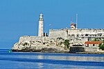 | La Habana, 23°8′0″N82°21′0″W / 23.13333°N 82.35000°W | Cultural: (iv), (v) | 143 (350) | 1982 | Havana was founded in 1519 by Spanish colonists, growing to become one of the Caribbean's primary shipbuilding centers by the 17th century. The old city was built in the Baroque and Neoclassical styles. Historical landmarks in Old Havana include La Cabaña, the Cathedral of Havana and the Great Theatre of Havana. | [20] |
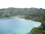
| Pitons Management Area |  | near Soufrière, 13°48′26″N61°4′13″W / 13.80722°N 61.07028°W | Natural: (vii), (viii) | 2,909 (7,190) | 2004 | [21] | |
| San Pedro de la Roca Castle, Santiago de Cuba |  | Santiago de Cuba Province, 19°58′0″N75°52′15″W / 19.96667°N 75.87083°W | Cultural: (iv), (v) | — | 1997 | The large fort was built to defend the important port of Santiago de Cuba. The design of the fortification was based on Italian and Renaissance architecture. The complex of magazines, bastions, and batteries is one of the most complete and well-preserved Spanish-American defense fortifications. | [22] |
| Trinidad and the Valley de los Ingenios |  | Sancti Spíritus Province, 21°48′11″N79°59′4″W / 21.80306°N 79.98444°W | Cultural: (iv), (v) | — | 1988 | The city of Trinidad was founded in the early 16th century. In 1518, Hernán Cortés began his expedition to conquer Mexico from the port at Trinidad. The city prospered throughout the colonial period in large part due to the success of the local sugar industry. The adjacent Valley de los Ingenios was the origin of the Cuban sugar industry, which emerged in the 18th century. It is home to numerous cane sugar mills, as well as cattle ranches and tobacco plantations. | [23] |
| Urban Historic Centre of Cienfuegos |  | Cienfuegos, 22°8′50″N80°27′10″W / 22.14722°N 80.45278°W | Cultural: (ii), (v) | — | 2005 | Cienfuegos was founded in 1819 as a Spanish colony, though its first inhabitants were French immigrants. It became a trade center in the sugar cane, tobacco, and coffee trade because of its location on the Bay of Cienfuegos. Because of its establishment in the later colonial period, the architecture has more modern influences: including modern ideas of urban planning. | [24] |
| Viñales Valley | 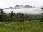 | Pinar del Río Province, 22°37′N83°43′W / 22.617°N 83.717°W | Cultural: (iv) | — | 1999 | The village of Viñales was founded in 1875 after the expansion of tobacco cultivation in the surrounding valley. The Valley features a karst topography, vernacular architecture, and traditional cultivation methods. The Valley was also the site of various military engagements in the Cuban War of Independence and Cuban Revolution. | [25] [26] |
| Volcanoes and Forests of Mount Pelée and the Pitons of Northern Martinique |  | Saint-Pierre, 14°49′23.39″N61°10′33.1″W / 14.8231639°N 61.175861°W | Cultural: (viii), (x) | 13,980 (34,500); buffer zone 28,826 (71,230) | 2023 | Volcanic area of global significance to vulcanology, and home to a number of endemic species. | [27] |
Location of sites

Location of World Heritage Sites in the Caribbean