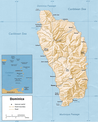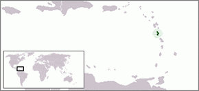
Dominica is an island in the Caribbean Sea, located about halfway between the French islands of Guadeloupe and Martinique. Its coordinates are 15 25 N, 61 20 W. It is known as "The Nature Island of the Caribbean" due to its spectacular, lush, and varied flora and fauna, which is protected by an extensive natural park system. It is the fourth largest island in the Eastern Caribbean with a population of people mainly of African descent.

Morne Diablotins is the highest mountain in Dominica, an island-nation in the Caribbean Lesser Antilles. It is the second highest mountain in the Lesser Antilles, after La Grande Soufrière in Guadeloupe. Morne Diablotins is located in the northern interior of the island, about 24 kilometres (15 mi) north of Dominica's capital Roseau and about 10 kilometres (6.2 mi) southeast of Portsmouth, the island's second-largest town. It is located within Morne Diablotin National Park.

Morne Trois Pitons National Park is a national park in Dominica established in July 1975, the first to be legally established in the country. It became a World Heritage Site in 1997. The park is named after its highest mountain, Morne Trois Pitons, meaning mountain of three peaks. The park is an area of significant volcanic activity. Features within the park include the Valley of Desolation, a region of boiling mud ponds and small geysers; the Boiling Lake; Titou Gorge; and Emerald Pool. The mountain is the second-highest peak in Dominica, being exceeded only by Morne Diablotins.

The imperial amazon or Dominican amazon, also known as the sisserou or sisserou parrot, is a parrot found only on the Caribbean island of Dominica. It has been designated as the national bird of Dominica, and features on the national flag of Dominica. The species is critically endangered. In 2019, it was estimated there were only about 50 mature individuals left in the wild.

Cabrits National Park is on a peninsula at the north end of the Caribbean island of Dominica, north of Portsmouth. The park protects tropical forest, coral reefs and wetlands. There are hiking trails and an English garrison called Fort Shirley.
Morne Watt or Watt Mountain is a mountain consisting of one or more stratovolcanoes at the south end of Dominica in the eastern Caribbean Sea. With an elevation of 1,224 m (4,016 ft), it is the third highest mountain in Dominica after Morne Diablotins and Morne Trois Pitons. The mountain is home to the Boiling Lake and Valley of Desolation thermal areas, both of which are the best-known volcanic features in Dominica and major tourist attractions in Morne Trois Pitons National Park.

Dominica, officially the Commonwealth of Dominica, is an island country in the Caribbean. It is part of the Windward Islands chain in the Lesser Antilles archipelago in the Caribbean Sea. The capital, Roseau, is located on the western side of the island. Dominica's closest neighbours are two constituent territories of the European Union, the overseas departments of France, Guadeloupe to the northwest and Martinique to the south-southeast. Dominica comprises a land area of 750 km2 (290 sq mi), and the highest point is Morne Diablotins, at 1,447 m (4,747 ft) in elevation. The population was 71,293 at the 2011 census.

The following outline is provided as an overview of and topical guide to Dominica:

The following is an alphabetical list of topics related to the nation of Dominica.

Dominica Botanic Gardens is located on the Caribbean island-nation of Dominica, in the capital of Roseau. Once known as one of the finest botanical gardens in the region, it was severely damaged by Hurricane David in 1979. Following restoration efforts, it remains a focus of cultural life in Roseau, and a center of conservation research on Dominica.
The Dominican snout is a species of snout butterfly that is endemic to Dominica, an island nation in the Caribbean Lesser Antilles.
Morne, Morné, Mörne, etc. may refer to:

The Mahé highlands and surrounding areas Important Bird Area occupy the central and north-western part of the island of Mahé in the Seychelles archipelago of the western Indian Ocean.

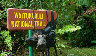
The Waitukubuli National Trail is a hiking trail spanning the island of Dominica. It is the longest hiking trail in the Caribbean, at 115 miles (185 km) long. Its name comes from the original Kalinago name of the island, Waitukubuli, meaning "tall is her body". The trails’s management falls under Dominica's Forestry Division.

The Syndicate Nature Trail is a hiking trail in Dominica. It is one of two nature trails in Morne Diablotin National Park. It is located in the foothills of Morne Diablotin, Dominica's tallest mountain, near the edge of the Picard River Gorge.


