Dominica is an island in the Caribbean Sea, located about halfway between the French islands of Guadeloupe and Martinique. Its coordinates are 15 25 N, 61 20 W. It is known as "The Nature Island of the Caribbean" due to its spectacular, lush, and varied flora and fauna, which is protected by an extensive natural park system. It is the fourth largest island in the Eastern Caribbean with a population of people mainly of African descent.

The sperm whale or cachalot is the largest of the toothed whales and the largest toothed predator. It is the only living member of the genus Physeter and one of three extant species in the sperm whale family, along with the pygmy sperm whale and dwarf sperm whale of the genus Kogia.

The toothed whales are a parvorder of cetaceans that includes dolphins, porpoises, and all other whales possessing teeth, such as the beaked whales and sperm whales. 73 species of toothed whales are described. They are one of two living groups of cetaceans, the other being the baleen whales (Mysticeti), which have baleen instead of teeth. The two groups are thought to have diverged around 34 million years ago (mya).

The Channel Islands National Marine Sanctuary is a sanctuary off the coast of Santa Barbara and Ventura counties in Southern California 350 miles south of San Francisco and 95 miles north of Los Angeles. It was designated in 1980 by the National Oceanic and Atmospheric Administration.

Gwaii Haanas National Park Reserve, National Marine Conservation Area, and Haida Heritage Site, usually referred to simply as Gwaii Haanas, is located in southernmost Haida Gwaii, 130 kilometres off the mainland of British Columbia, Canada. Gwaii Haanas protects an archipelago of 138 islands, the largest being Moresby Island and the southernmost being Kunghit Island. "Gwaii Haanas" means "Islands of Beauty" in X̱aayda kíl, the language of the Haida people.

Paracas National Reserve is a protected area located in the region of Ica, Peru and protects desert and marine ecosystems for their conservation and sustainable use. There are also archaeological remains of the Paracas culture inside the reserve.

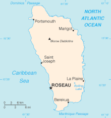
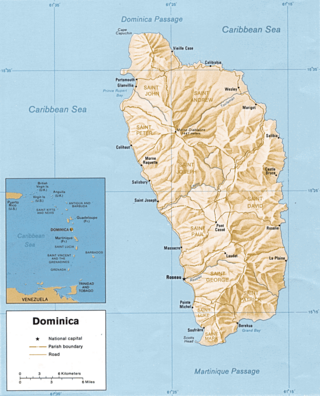
Cabrits National Park is on a peninsula at the north end of the Caribbean island of Dominica, north of Portsmouth. The park protects tropical forest, coral reefs and wetlands. There are hiking trails and an English garrison called Fort Shirley.

The wildlife of Cameroon is composed of its flora and fauna. Bordering Nigeria, it is considered one of the wettest parts of Africa and records Africa's second highest concentration of biodiversity. To preserve its wildlife, Cameroon has more than 20 protected reserves comprising national parks, zoos, forest reserves and sanctuaries. The protected areas were first created in the northern region under the colonial administration in 1932; the first two reserves established were Mozogo Gokoro Reserve and the Bénoué Reserve, which was followed by the Waza Reserve on 24 March 1934. The coverage of reserves was initially about 4 percent of the country's area, rising to 12 percent; the administration proposes to cover 30 percent of the land area.

Dominica, officially the Commonwealth of Dominica, is an island country in the Caribbean. The capital, Roseau, is located on the western side of the island. It is geographically situated as part of the Windward Islands chain in the Lesser Antilles archipelago in the Caribbean Sea. Dominica's closest neighbours are two constituent territories of the European Union, the overseas departments of France, Guadeloupe to the northwest and Martinique to the south-southeast. Dominica comprises a land area of 750 km2 (290 sq mi), and the highest point is Morne Diablotins, at 1,447 m (4,747 ft) in elevation. The population was 71,293 at the 2011 census.
The following outline is provided as an overview of and topical guide to Dominica:

Point Sur State Marine Reserve (SMR) and Point Sur State Marine Conservation Area (SMCA) are two adjoining marine protected areas that lie offshore of Point Sur, part of the Big Sur area on California's central coast. The combined area of these marine protected areas is 19.68 square miles (51.0 km2). The SMR protects all marine life within its boundaries. Fishing and taking of all living marine resources is prohibited in the SMR. Within the SMCA, fishing and taking of all living marine resources is prohibited except the commercial and recreational take of salmon and albacore.
Gwaii Haanas National Marine Conservation Area Reserve and Haida Heritage Site is a National Marine Conservation Area of Canada. It is located off the coast of the southernmost Haida Gwaii, 130 kilometres off the mainland of British Columbia. It is immediately adjacent to Gwaii Haanas National Park Reserve and Haida Heritage Site. The level of protection differs from that of the National Park Reserve, however, allowing sustainable use of some natural resources in the area. Gwaii Haanas National Marine Conservation Area Reserve, which covers 3,400 square kilometres, is "a primary feeding habitat" of the humpback whale protected by Canada's Species at Risk Act (SARA).

The South-west Corner Marine Park is a marine protected area on the lower south west and southern coast of Western Australia, one of 14 in the South-west Marine Parks Network.

Great Australian Bight Marine Park is a marine protected area located in the Great Australian Bight south of South Australia in waters within the Australian Exclusive economic zone.
Western Kangaroo Island Marine Park is a marine protected area located south of South Australia in waters within the Australian Exclusive economic zone to the south-west of Kangaroo Island and ranging in depth from 15 metres to 165 metres.
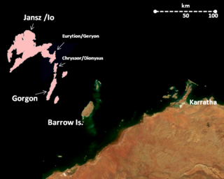
The Montebello Island Marine Park is located off the northwest coast of Western Australia, about 1,600 km north of Perth, and 120 km west of Dampier. The reserve includes the entire group of Montebello Islands.
Protected areas of the Caribbean are significant in a region of particular ecological vulnerability, including the impact of climate change and the impact of tourism.

Hikurangi Marine Reserve is a marine reserve off the coast of the Kaikōura District, in the Canterbury Region of New Zealand's South Island. It is the largest and deepest marine reserve in New Zealand.
Cetaceans form an infra-order of marine mammals. In 2020, approximately 86 species of cetaceans had been identified worldwide. Among these species, at least 35 have been sighted in the wider Caribbean region with very widespread distribution and density variations between areas. Caribbean waters are a preferred breeding site for several species of mysticeti, who live further north the rest of the year. The tucuxi and the boto live at the southern periphery of the Caribbean region in the freshwaters of the Amazon river and surrounding drainage basins.