Plantations are farms specializing in cash crops, usually mainly planting a single crop, with perhaps ancillary areas for vegetables for eating and so on. Plantations, centered on a plantation house, grow crops including cotton, cannabis, coffee, tea, cocoa, sugar cane, opium, sisal, oil seeds, oil palms, fruits, rubber trees and forest trees. Protectionist policies and natural comparative advantage have sometimes contributed to determining where plantations are located.

Sugar plantations in the Caribbean were a major part of the economy of the islands in the 18th, 19th, and 20th centuries. Most Caribbean islands were covered with sugar cane fields and mills for refining the crop. The main source of labor, until the abolition of chattel slavery, was enslaved Africans. After the abolition of slavery, indentured laborers from India, China, Portugal and other places were brought to the Caribbean to work in the sugar industry. These plantations produced 80 to 90 percent of the sugar consumed in Western Europe, later supplanted by European-grown sugar beet.
A plantation economy is an economy based on agricultural mass production, usually of a few commodity crops, grown on large farms worked by laborers or slaves. The properties are called plantations. Plantation economies rely on the export of cash crops as a source of income. Prominent crops included Red Sandalwood, cotton, rubber, sugar cane, tobacco, figs, rice, kapok, sisal, and species in the genus Indigofera, used to produce indigo dye.

Established in 1994, the Cane River Creole National Historical Park serves to preserve the resources and cultural landscapes of the Cane River region in Natchitoches Parish, Louisiana. Located along the Cane River Lake, the park is approximately 63 acres and includes two French Creole cotton plantations, Oakland and Magnolia. Both plantations are complete in their historic settings, including landscapes, outbuildings, structures, furnishings, and artifacts; and they are the most intact French Creole cotton plantations in the United States. In total, 65 historic structures and over a million artifacts enhance the National Park Service mission as it strives to tell the story of the evolution of plantation agriculture through the perspective of the land owners, enslaved workers, overseers, skilled workers, and tenant farmers who resided along the Cane River for over two hundred years. This park is included as a site on the Louisiana African American Heritage Trail.
A Slave Bell is a bell that was rung to regulate the day on slave plantations and in slave societies. They were featured in slave plantations throughout the Americas and notably in the slavery systems in Cape Colony, present-day South Africa. The structures they were housed in, most often tall pillars and towers, became landmarks on the plantation and could be used to surveillance the enslaved workers. In some cases, these structures have become a symbolic feature of the architectural style of that region and the architecture of plantation slavery. In South Africa, the pillars of the slave bell is a distinctive feature of the Cape Dutch architectural style.

Viñales is a town and municipality in the north-central Pinar del Río Province of Cuba. The town consists mostly of one-story wooden houses with porches. The municipality is dominated by low mountain ranges of the Cordillera de Guaniguanico such as Sierra de los Órganos. Typical outcrops known as mogotes complete the karstic character of the landscape.
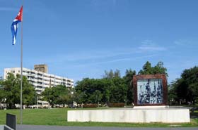
Artemisa is a municipality and city in Cuba, formerly part of La Habana Province. According to a law approved by the Cuban National Assembly in August 2010, Artemisa became the capital city of the newly formed Artemisa Province, which comprises eight municipalities of the former La Habana Province and three from Pinar del Río. It has an area of 642.0 square kilometers and a population of over 86,444 inhabitants (2022).

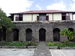
Hacienda Buena Vista, also known as Hacienda Vives, was a coffee plantation located in Barrio Magueyes, Ponce, Puerto Rico. The original plantation dates from the 19th century. The plantation was started by Don Salvador de Vives in 1833.
Valle de los Ingenios, also named Valley de los Ingenios or Valley of the Sugar Mills, is a series of three interconnected valleys about 12 kilometres (7.5 mi) outside of Trinidad, Cuba. The three valleys, San Luis, Santa Rosa, and Meyer, were a centre for sugar production from the late 18th century until the late 19th century. At the peak of the industry in Cuba there were over fifty sugar cane mills in operation in the three valleys, with over 30,000 slaves working in the mills and on the sugar cane plantations that surrounded them.

Coffee production in Colombia has a reputation for producing mild, well-balanced coffee beans. Colombia's average annual coffee production of 11.5 million bags is the third total highest in the world, after Brazil and Vietnam, though highest in terms of the arabica bean. The beans are exported to United States, Germany, France, Japan, and Italy. Most coffee is grown in the Colombian coffee growing axis region, while other regions focus on quality instead of volumes, such as Sierra Nevada de Santa Marta. In 2007, the European Union granted Colombian coffee a protected designation of origin status. In 2011, UNESCO declared the "Coffee Cultural Landscape" of Colombia, a World Heritage site.

Wajay is a ward of the city of Havana, the capital of Cuba, belonging to the municipal borough of Boyeros. In 2011, it had a population of 47,954.

Reef Bay Sugar Factory Historic District is a historic section of Saint John, United States Virgin Islands located on the south central coast adjacent to Reef Bay. The land is the site of a sugar factory. The property was added to the U.S. National Register of Historic Places on July 23, 1981.

Brazil produces about a third of the world's coffee, making the country by far the world's largest producer. Coffee plantations, covering some 27,000 km2 (10,000 sq mi), are mainly located in the southeastern states of Minas Gerais, São Paulo and Paraná where the environment and climate provide ideal growing conditions.

The Slave Route Project is a UNESCO initiative that was officially launched in 1994 in Ouidah, Benin. It is rooted in the mandate of the organization, which believes that ignorance or concealment of major historical events constitutes an obstacle to mutual understanding, reconciliation and cooperation among peoples. The project breaks the silence surrounding the slave trade and slavery that has affected all continents and caused great upheavals that have shaped our modern societies. In studying the causes, the modalities and the consequences of slavery and the slave trade, the project seeks to enhance the understanding of diverse histories and heritages stemming from this global tragedy.

Coffee has been grown in Cuba since the mid-18th century. Boosted by French farmers fleeing the revolution in Haiti, coffee farms expanded from the western plains to the nearby mountain ranges. Coffee production in eastern Cuba significantly increased during the 19th and early 20th centuries. At its peak production, Cuba exported more than 20,000 metric tons of coffee beans per year in the mid-1950s. After the Cuban Revolution and the nationalization of the coffee industry, coffee production slowly began to decline until it reached all time lows during the Great Recession. Once a major Cuban export, it now makes up an insignificant portion of Cuban trade. By the 21st century, 92 percent of the country's coffee was grown in area of the Sierra Maestra mountains. All Cuban coffee is exported by Cubaexport, which pays regulated prices to coffee growers and processors.

Carlota Lucumí, also known as La Negra Carlota was an African-born enslaved Cuban woman of Yoruba origin. Carlota, alongside fellow enslaved Lucumí Ferminia, was known as a leader of the slave rebellion at the Triunvirato plantation in Matanzas, Cuba during the Year of the Lash in 1843–1844. Together with Ferminia Lucumí, Carlota led the slave uprising of the sugar mill "Triunvirato" in the province of Matanzas, Cuba on November 5, 1843.
Theresa A. Singleton is an American archaeologist and writer who focuses on the archaeology of African Americans, the African diaspora, and slavery in the United States. She is a leading archaeologist applying comparative approaches to the study of slavery in the Americas. Singleton has been involved in the excavation of slave residences in the southern United States and in the Caribbean. She is a professor of anthropology at Syracuse University, and serves as a curator for the National Museum of Natural History.
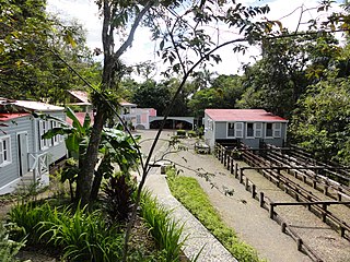
Museo Hacienda Buena Vista is a historic coffee plantation farm museum in Barrio Magueyes, Ponce, Puerto Rico. The museum opened in 1987, and receives some 40,000 visitors a year. The museum has been described as "Puerto Rico's first living museum of art and science."
In Brazil's economic history, the coffee cycle was a period in which coffee was the main export product of the Brazilian economy. It began in the mid-19th century and ended in 1930. The coffee cycle succeeded the gold cycle, which had come to an end after the exhaustion of the mines a few decades earlier, and put an end to the economic crisis generated by this decadence.