Hurricane Klaus (1990)

Last updated
Map key
  Tropical depression (≤38 mph, ≤62 km/h)
  Tropical storm (39–73 mph, 63–118 km/h)
  Category 1 (74–95 mph, 119–153 km/h)
  Category 2 (96–110 mph, 154–177 km/h)
  Category 3 (111–129 mph, 178–208 km/h)
  Category 4 (130–156 mph, 209–251 km/h)
  Category 5 (≥157 mph, ≥252 km/h)
  Unknown
Storm type
Disc Plain black.svg Tropical cyclone
Solid black.svg Subtropical cyclone
ArrowUp.svg Extratropical cyclone, remnant low, tropical disturbance, or monsoon depression

A tropical wave moved off the coast of Africa on September 27. It tracked westward to the south of a subtropical ridge, becoming convectively active, and a low-level circulation was observed as it passed south of the Cape Verde islands on September 28. The organization of the convection oscillated over the subsequent days, and a few times the system showed signs of developing into a tropical depression. As it approached the Lesser Antilles it organized further, and despite unfavorable upper-level wind shear the system developed into Tropical Depression Thirteen on October 3 while located about 115 miles (185 km)/h) east of Dominica. Located in an area of weak steering currents, the depression drifted to the northwest, and about six hours after first developing the cyclone intensified into a tropical storm; the National Hurricane Center designated it with the name Klaus . [1]

Upon becoming a tropical storm, Klaus was located in an area of 29 mph (47 km/h) of wind shear, although concurrently it was located over warm water temperatures of 83.1 °F (28.4 °C). [2] Tracking through a highly baroclinic environment, [3] the storm became better organized, and at 1200 UTC on October 5 Klaus attained hurricane status about 30 miles (48 km) east of Antigua; shortly thereafter, it passed 12 miles (19 km) east of Barbuda, its closest point of approach to the Lesser Antilles. Klaus reached peak winds of 80 mph (130 km/h) and a minimum central pressure of 985.0 mbar (29.09 inHg), though most of its deep convection and strong winds remained to its northeast due to wind shear. [1] At the time the hurricane was forecast to continue tracking to the north-northwest. However, after weakening to a tropical storm on October 6, Klaus turned westward. [3]

Klaus continued tracking just north of the Lesser Antilles, and after continuing to deteriorate from the wind shear, the cyclone weakened to a tropical depression on October 8 to the north of Puerto Rico. Later that day, convection redeveloped over the center, and Klaus re-attained tropical storm status as it accelerated toward the northeast Bahamas; it briefly reached winds of 50 mph (80 km/h). [1] A low pressure area to its west over Cuba had been steadily intensifying and building toward the surface, and on October 9 it developed into a tropical depression; the cyclone became the dominant system, eventually becoming Marco, and Klaus dissipated under the influence of the system late on October 9. The remnant moisture continued to the northwest, reaching the coast of South Carolina by October 11. [4]

Preparations

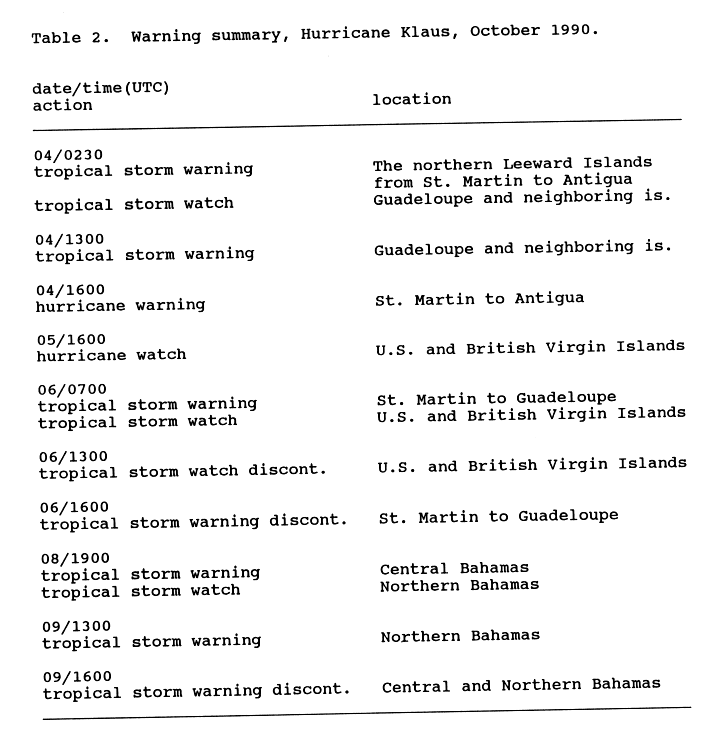
Shortly after Klaus attained tropical storm status early on October 4, a tropical storm warning was issued for the northern Leeward Islands from Saint Martin to Antigua, which was upgraded to a hurricane warning as its quick strengthening became apparent; additionally, the government of France issued a tropical storm warning for Guadeloupe. A hurricane watch was issued for the Virgin Islands, though it was dropped as Klaus began to weaken. [5] In Guadeloupe, officials advised citizens to transport livestock to safer areas, and also to avoid potentially flooded areas. Prior to its arrival, schools were closed in Martinique, [6] Sint Maarten, and Antigua. The VC Bird International Airport was closed during the passage of the hurricane. [7]

Later in its duration, the government of The Bahamas issued a tropical storm warning for the central and later northern Bahamas, though it was discontinued as the cyclone dissipated. [5] Due to Hurricane Klaus, Space Shuttle Columbia's launch was delayed.

Impact

Hurricane Klaus dropped moderate to heavy rainfall across the Lesser Antilles, potentially as high as 15 inches (380 mm); the hurricane affected many areas struck by Hurricane Hugo in the previous year. On Barbados, flooding from the rainfall blocked a few roads and forced a few families to move to safer areas; lightning from the outskirts of the storm left a portion of the island without power. [6] High winds and rainfall affected the island of Saint Lucia, which destroyed about 15% of the nation's banana crop for the year; damage totaled about $1 million (1990  USD). [8]

The rainfall resulted in severe flooding on Martinique, which accrued to almost 10 feet (3.0 m) in some locations; two sisters drowned near Saint-Joseph after a bridge was washed away. [6] Several landslides were reported on the island. [9] The passage of the cyclone left damaged and power and telephone systems. 750 people evacuated their homes in Le Lamentin due to flooding, [6] and a total of 1,500 residents were left homeless on the island. [7] Offshore, rough conditions damaged a fishing vessel, leaving its two passengers drifting on the boat for 25 days before being rescued about 640 miles (1,030 km) to the north-northwest of Martinique. [10] In all, seven people were killed on the island. [11]

On Dominica, winds from the hurricane damaged power lines and downed trees in the northern portion of the island. [6] High winds on Antigua damaged a few roofs, and also downed communications from two radio networks. [7] The outer rainbands of the storm dropped light rainfall on the United States Virgin Islands, reaching about 1.25 inches (32 mm) on Saint Thomas; wind gusts peaked at 33 mph (53 km/h) on Saint Croix. [12] Moderate rainfall continued into the Turks and Caicos Islands, with Grand Turk reporting a total of 4 inches (100 mm) in 36 hours. [4]

On the east coast of Florida, Klaus produced 15 feet (4.6 m) waves and tides of 3 feet (0.91 m) above normal. Beach erosion was reported along the east coast, due to persistent easterly winds. [13] As the remnant moisture of Klaus entered the southeastern United States, it produced heavy rainfall between 10 and 15 inches (254 and 381 millimetres) of rainfall in South Carolina, with slightly lower totals in North Carolina. In South Carolina, the rainfall caused a dam to burst, killing four people. [4] About two days after the remnants of Klaus entered the southeastern United States, Tropical Storm Marco made landfall on northwestern Florida, dropping more heavy rainfall and causing heavy damage across the region. [14]

Retirement

Due to the storm's impacts on the islands of the lesser Antilles, the World Meteorological Organization retired the name Klaus from the Atlantic hurricane name lists following the 1990 season. [15] It was replaced with Kyle for the 1996 season. [16]

See also

Related Research Articles

<span class="mw-page-title-main">Hurricane Hortense</span> Category 4 Atlantic hurricane in 1996

Hurricane Hortense was the first tropical cyclone to make landfall in Guadeloupe and Puerto Rico since Hurricane Hugo in 1989, and the second most intense hurricane during the 1996 Atlantic hurricane season. The eighth tropical cyclone, eighth named storm, and sixth hurricane of the season. Hortense developed on September 3 from a tropical wave in the central Atlantic Ocean. Initially a tropical depression, it headed westward without significant strengthening for four days due to unfavorable upper-level winds. While nearing the Lesser Antilles upper-level winds decreased, allowing the depression to become Tropical Storm Hortense on September 7. Hortense crossed Guadeloupe on September 8 and entered the Caribbean Sea. By on the following day, it was upgraded to a hurricane while curving northwestward. Hortense made landfall in Puerto Rico on September 9 and brushed the Dominican Republic shortly thereafter. After re-entering the Atlantic, Hortense began to substantially strengthen and peaked as a 140 mph (220 km/h) Category 4 hurricane early on September 13. Thereafter, the storm steadily weakened as it tracked rapidly north-northeastward. Early on September 15, Hortense made landfall in Nova Scotia as a minimal Category 1 hurricane. It quickly weakened further to a tropical storm before re-entering the Atlantic to the south of Newfoundland. Late on September 15, Hortense transitioned into an extratropical cyclone and subsequently merged with a frontal system about 24 hours later.

<span class="mw-page-title-main">1995 Atlantic hurricane season</span> Hurricane season in the Atlantic Ocean

The 1995 Atlantic hurricane season was a very active Atlantic hurricane season, and is considered to be the start of an ongoing era of high-activity tropical cyclone formation. The season produced twenty-one tropical cyclones, nineteen named storms, as well as eleven hurricanes and five major hurricanes. The season officially began on June 1 and ended on November 30, dates which conventionally delimit the period of each year when most tropical cyclones develop in the Atlantic basin. The first tropical cyclone, Hurricane Allison, developed on June 2, while the season's final storm, Hurricane Tanya, transitioned into an extratropical cyclone on November 1. The very active Atlantic hurricane activity in 1995 was caused by La Niña conditions, which also influenced an inactive Pacific hurricane season. It was tied with 1887 Atlantic hurricane season with 19 named storms, which was later equalled by the 2010, 2011, and 2012 seasons.

<span class="mw-page-title-main">2003 Atlantic hurricane season</span> Hurricane season in the Atlantic Ocean

The 2003 Atlantic hurricane season was a very active season with tropical cyclogenesis occurring before and after the official bounds of the season—the first such occurrence since the 1970 season. The season produced 21 tropical cyclones, of which 16 developed into named storms; seven of those attained hurricane status, of which three reached major hurricane status. The strongest hurricane of the season was Hurricane Isabel, which reached Category 5 status on the Saffir–Simpson hurricane scale northeast of the Lesser Antilles; Isabel later struck North Carolina as a Category 2 hurricane, causing $3.6 billion in damage and a total of 51 deaths across the Mid-Atlantic region of the United States.

<span class="mw-page-title-main">1963 Atlantic hurricane season</span> Hurricane season in the Atlantic Ocean

The 1963 Atlantic hurricane season was a slightly below average season in terms of tropical cyclone formation, with a total of ten nameable storms. Even so, it was also a notoriously deadly and destructive season. The season officially began on June 15, 1963, and lasted until November 15, 1963. These dates conventionally delimit the period of each year when most tropical cyclones form in the Atlantic basin. The first system, an unnamed tropical storm, developed over the Bahamas on June 1.

<span class="mw-page-title-main">1967 Atlantic hurricane season</span> Hurricane season in the Atlantic Ocean

The 1967 Atlantic hurricane season was an active Atlantic hurricane season overall, producing 13 nameable storms, of which 6 strengthened into hurricanes. The season officially began on June 1, 1967, and lasted until November 30, 1967. These dates, adopted by convention, historically describe the period in each year when most tropical cyclogenesis occurs in the Atlantic Ocean. The season's first system, Tropical Depression One, formed on June 10, and the last, Tropical Storm Heidi, lost tropical characteristics on November 2.

<span class="mw-page-title-main">1970 Atlantic hurricane season</span> Hurricane season in the Atlantic Ocean

The 1970 Atlantic hurricane season officially began on June 1 and lasted until November 30. These dates conventionally delimit the period of each year when most tropical cyclones form in the Atlantic basin. The season was fairly average, with 14 named storms forming, of which seven were hurricanes. Two of those seven became major hurricanes, which are Category 3 or higher on the Saffir–Simpson scale. Also, this was the first season in which reconnaissance aircraft flew into all four quadrants of a tropical cyclone.

<span class="mw-page-title-main">1990 Atlantic hurricane season</span> Hurricane season in the Atlantic Ocean

The 1990 Atlantic hurricane season was the most active Atlantic hurricane season since 1969, with a total of 14 named storms. The season also featured eight hurricanes, one of which intensified into a major hurricane. It officially began on June 1, 1990, and lasted until November 30, 1990. These dates conventionally delimit the period of each year when most tropical cyclones form in the Atlantic basin. However, tropical cyclogenesis can occur prior to the start of the season, as demonstrated with Tropical Depression One, which formed in the Caribbean Sea on May 24.

<span class="mw-page-title-main">Hurricane Erika (1997)</span> Category 3 Atlantic hurricane

Hurricane Erika was the strongest and longest-lasting tropical cyclone in the 1997 Atlantic hurricane season. It developed from a tropical wave on September 3 and moved west-northwestward across the tropical Atlantic Ocean, steadily intensifying until it attained hurricane status on September 4, becoming the fifth named storm and third hurricane of the season. Erika passed a short distance to the north of the Lesser Antilles, and later turned to the north in response to an approaching trough. The hurricane quickly strengthened to become the only major hurricane of the season, reaching maximum sustained winds of 125 mph (201 km/h) on September 8; after maintaining its peak strength for 24 hours, Erika began to weaken as it passed over cooler waters. It turned to the east, weakened to a tropical storm, and became extratropical after passing near the Azores archipelago.

<span class="mw-page-title-main">Hurricane Jose (1999)</span> Category 2 Atlantic hurricane in 1999

Hurricane Jose was the fourteenth tropical cyclone, tenth named storm, and seventh hurricane of the annual hurricane season that caused moderate damage in the Lesser Antilles in October 1999. Jose developed from a tropical wave several hundred miles east of the Windward Islands on October 17. The depression intensified and was subsequently upgraded to Tropical Storm Jose on October 18. The storm tracked northwestward and was upgraded to a hurricane the following day as it approached the northern Leeward Islands. Jose briefly peaked as a Category 2 hurricane with winds of 100 mph (160 km/h) on October 20. However, wind shear weakened the storm back to a Category 1 hurricane before it struck Antigua. Further deterioration occurred and Jose weakened to a tropical storm before landfall in Tortola on October 21. While located north of Puerto Rico on October 22, the storm turned northward, shortly before curving north-northeastward. Wind shear decreased, allowing Jose to re-intensify into a hurricane while passing east of Bermuda on October 24. However, on the following day, wind shear increased again, while sea surface temperatures decreased, causing Jose to weaken and quickly transition into an extratropical cyclone.

<span class="mw-page-title-main">Hurricane Debby (2000)</span> Category 1 Atlantic hurricane in 2000

Hurricane Debby caused minor damage in the Greater and Lesser Antilles in August 2000. The seventh tropical cyclone, fourth named storm, and second hurricane of the annual season, Debby developed from a tropical wave east of the Lesser Antilles on August 19. Favorable conditions allowed the depression to become Tropical Storm Debby early on August 20, and further strengthening into a hurricane occurred 24 hours later. Sustained winds peaked at 85 mph (137 km/h) on August 21. Debby made three landfalls on August 22, in Barbuda, Saint Barthélemy, and Virgin Gorda, before re-entering the Atlantic north of Puerto Rico. As Debby moved parallel to the north coast of Hispaniola late on August 23, it weakened back to a tropical storm. The storm tracked westward and weakened further, instead of approaching Florida and strengthening into a major hurricane. While south of eastern Cuba on August 24, Debby was downgraded to a tropical depression, six hours before completely dissipating.

<span class="mw-page-title-main">Tropical Storm Helene (2000)</span> Atlantic tropical storm in 2000

Tropical Storm Helene was a long-lived tropical cyclone that oscillated for ten days between a tropical wave and a 70 mph (110 km/h) tropical storm. It was the twelfth tropical cyclone and eighth tropical storm of the 2000 Atlantic hurricane season, forming on September 15 east of the Windward Islands. After degenerating into a tropical wave, the system produced flooding and mudslides in Puerto Rico. It reformed into a tropical depression on September 19 south of Cuba, and crossed the western portion of the island the next day while on the verge of dissipation. However, it intensified into a tropical storm in the Gulf of Mexico, reaching its peak intensity while approaching the northern Gulf Coast.

<span class="mw-page-title-main">Tropical Storm Chris (2006)</span> Atlantic tropical storm in 2006

Tropical Storm Chris was the fourth tropical storm of the 2006 Atlantic hurricane season. Forming on July 31 in the Atlantic Ocean east of the Leeward Islands from a tropical wave, Chris moved generally to the west-northwest, skirting the northern fringes of the Caribbean islands. Chris was a relatively short-lived storm, reaching a peak intensity with winds at 65 mph (105 km/h) on August 2, while positioned north of St. Martin. The storm gradually weakened before finally dissipating on August 5, near eastern Cuba. Overall impact was minimal, amounting to moderate amounts of rainfall throughout its path. No deaths were reported.

<span class="mw-page-title-main">Hurricane Iris (1995)</span> Category 2 Atlantic hurricane in 1995

Hurricane Iris was the first of three tropical cyclones to affect the Lesser Antilles in a three-week period, preceding the more destructive hurricanes Luis and Marilyn. The ninth named storm and fifth hurricane of the 1995 Atlantic hurricane season, Iris developed from a tropical wave to the east of the Lesser Antilles on August 22 and attained hurricane status within 30 hours. The hurricane weakened to a tropical storm before crossing the islands of the eastern Caribbean from August 26 through August 28. During that time, Iris became one of four active tropical storms in the Atlantic basin. Earlier it had interacted with Hurricane Humberto, and beginning on August 30, Iris interacted with Tropical Storm Karen. Iris re-intensified into a hurricane and attained peak sustained winds of 110 mph (175 km/h) while moving slowly across the central Atlantic. The hurricane accelerated to the north and absorbed a dissipating Karen on September 3. Iris weakened to a tropical storm and became extratropical on September 4, though its remnants re-attained hurricane-force winds, before affecting western Europe on September 7. The storm dissipated soon afterward.

<span class="mw-page-title-main">Hurricane Klaus (1984)</span> Category 1 Atlantic hurricane in 1984

Hurricane Klaus was a North Atlantic hurricane that hit the Leeward Islands from the west in November of the 1984 Atlantic hurricane season. Forming from a broad area of low pressure on November 5, Klaus maintained a northeast movement throughout much of its path. After making landfall on extreme eastern Puerto Rico, it passed to the north of the Leeward Islands, resulting in strong southwesterly winds and rough seas. Klaus attained hurricane status and reached peak winds of 90 mph (145 km/h) before becoming extratropical over cooler waters on November 13. The storm dropped heavy rainfall in Puerto Rico, causing minor flooding and light damage. Klaus caused heavy marine damage in the Leeward Islands, including wrecking at least three ships. The Virgin Islands experienced heavy damage as well.

<span class="mw-page-title-main">Tropical Storm Dean (2001)</span> Atlantic tropical storm in 2001

Tropical Storm Dean was a strong tropical storm that affected at least twelve islands along its path from the tropical Atlantic Ocean to east of Atlantic Canada in August 2001. Dean developed from a tropical wave on August 22 over the Lesser Antilles, and was initially predicted to intensify further to reach hurricane status. However, strong wind shear quickly weakened Dean to cause it to dissipate on August 23. The remnants turned northward, and redeveloped on August 26 to the north of Bermuda. Located over warm waters and in an area of favorable conditions, Dean steadily strengthened while moving to the northeast, and peaked just below hurricane status on August 27 about 465 miles (748 km) southwest of Newfoundland. The storm subsequently weakened over cooler waters, and became extratropical on August 28.

<span class="mw-page-title-main">Hurricane Olga</span> Category 1 Atlantic hurricane in 2001

Hurricane Olga was the fifteenth named storm and ninth hurricane of the 2001 Atlantic hurricane season. It was notable as it was the largest tropical cyclone by diameter of gale-force winds on record in the Atlantic at the time. Hurricane Olga formed as a subtropical cyclone on November 24. After acquiring tropical characteristics later that day, Olga meandered westward, and eventually reached hurricane status on November 26. Olga peaked as a 90 mph (140 km/h) Category 1 hurricane before the storm turned southwestward and weakening back into a tropical storm. On November 30 it deteriorated further to a tropical depression, although it re-intensified two days later to tropical storm intensity. Olga then dissipated as a tropical cyclone on December 4 east of the Bahamas. Its damaging effects were limited to ships at sea. The cyclone's remnants produced heavy rainfall across the Bahamas and Florida. It was a relatively rare storm to exist in December, which is outside of the normal Atlantic hurricane season.

<span class="mw-page-title-main">Tropical Storm Dorothy</span> Atlantic tropical storm in 1970

Tropical Storm Dorothy was the deadliest tropical cyclone of the 1970 Atlantic hurricane season. The fourth named storm and fifth tropical storm or hurricane of the season, Dorothy developed on August 17 from a tropical wave to the east of the Lesser Antilles. It tracked west-northwestward throughout its entire duration, and despite forecasts of attaining hurricane status, Dorothy reached peak winds of 70 mph (110 km/) – slightly below hurricane status. The storm struck Martinique on August 20, and subsequently began a gradual weakening trend in the Caribbean Sea. On August 23, Dorothy dissipated south of Hispaniola.

<span class="mw-page-title-main">Hurricane Gustav (1990)</span> Category 3 Atlantic hurricane in 1990

Hurricane Gustav was the only major hurricane that formed during the 1990 Atlantic hurricane season. Developing out of a tropical wave on August 24, Gustav tracked westward across the Atlantic Ocean, steadily intensifying. The storm reached hurricane-status on August 26 and reached its initial peak intensity as a strong Category 2 hurricane the following day. After turning towards the north and weakening due to increased wind shear, the storm encountered more favorable conditions and re-intensified, attaining peak winds of 120 mph (190 km/h) around 0600 UTC on August 31. Gradual weakening took place in the following days. on September 2, the former hurricane underwent an extratropical transition and dissipated shortly after completing it. At that time, the system was located roughly 230 miles (370 km) south of Iceland.

<span class="mw-page-title-main">Tropical Storm Erika (2009)</span> Atlantic tropical storm in 2009

Tropical Storm Erika was a short-lived tropical cyclone that brought minor impacts to the Lesser Antilles. The fifth named storm of the 2009 Atlantic hurricane season, Erika originated out of a tropical wave on September 1 near the Lesser Antilles. Although it was a disorganized system, it was immediately declared a tropical storm, rather than a tropical depression. Later that day, the system reached its peak intensity with winds of 50 mph (85 km/h) and a barometric pressure of 1004 mbar. Increased wind shear caused the storm to weaken shortly thereafter, with Erika barely maintaining tropical storm-status by September 2. Later that day, the storm passed over the island of Guadeloupe and entered the Caribbean Sea. On September 3, Erika weakened to a tropical depression as the low pressure center became fully displaced from convective activity. Later that day, the system degenerated into a remnant low before dissipating near Puerto Rico on September 4.

<span class="mw-page-title-main">2009 Atlantic hurricane season</span> Hurricane season in the Atlantic Ocean

The 2009 Atlantic hurricane season was a near-average Atlantic hurricane season that produced eleven tropical cyclones, nine named storms, three hurricanes, and two major hurricanes. It officially began on June 1 and ended on November 30, dates that conventionally delimit the period of each year when most tropical cyclones develop in the Atlantic basin. The season's first tropical cyclone, Tropical Depression One, developed on May 28, while the final storm, Hurricane Ida, dissipated on November 10. The most intense hurricane, Bill, was a powerful Cape Verde-type hurricane that affected areas from the Leeward Islands to Newfoundland. The season featured the lowest number of tropical cyclones since the 1997 season, and only one system, Claudette, made landfall in the United States. Forming from the interaction of a tropical wave and an upper-level low, Claudette made landfall on the Florida Panhandle with maximum sustained winds of 45 mph (70 km/h) before quickly dissipating over Alabama. The storm killed two people and caused $228,000 in damage.

References

  1. 1 2 3 National Hurricane Center (1990). "Hurricane Klaus Preliminary Report" . Retrieved 2007-10-31.
  2. Mark DeMaria; Jong-Jin Baik; John Kaplan (1991). "Upper-Level Eddy Angular Momentum Fluxes and Tropical Cyclone Intensity Changes" (PDF). American Meteorological Society. Retrieved 2007-11-01.[ dead link ]
  3. 1 2 Mukut Mather; Janene Ruess (1992). "Further Evaluation of the Quasi-Lagrangian Model's Forecast Track Guidance" (PDF). American Meteorological Society.
  4. 1 2 3 National Hurricane Center (1990). "Hurricane Klaus Preliminary Report (Page 2)" . Retrieved 2007-10-31.
  5. 1 2 National Hurricane Center (1990). "Hurricane Klaus Preliminary Report (Page 5)" . Retrieved 2007-11-03.
  6. 1 2 3 4 5 Robert Glass (1990-10-04). "Storm Klaus Bears Down on Caribbean, Hurricane Warnings Issued". Associated Press.
  7. 1 2 3 Robert Glass (1990-10-05). "Caribbean Islanders Brace for Hurricane Klaus". Associated Press.
  8. Robert Glass (1990-10-06). "Klaus Weakens, Moves Over Open Atlantic Waters". Associated Press. Retrieved 2012-12-07.
  9. "First Snow in Rockies; Northeast Basks in Summery Weather". Associated Press. 1990-10-06.
  10. "Two Fishermen Survive Hurricane After Being 25 Days Adrift". Associated Press. 1990-11-01.
  11. Max Mayfield; Miles Lawrence (1991). "Atlantic Hurricane Season of 1990". Monthly Weather Review. 119 (8). National Hurricane Center: 2014. Bibcode:1991MWRv..119.2014M. doi: 10.1175/1520-0493(1991)119<2014:AHSO>2.0.CO;2 . ISSN   1520-0493. S2CID   119504549 . Retrieved 2011-03-01.
  12. Gloria Forthun (2005). "Tropical Systems Affecting the U.S. Virgin Islands 1989-1999 as Compared to Hurricane Hugo" (PDF). Southeast Regional Climate Center. Archived from the original (PDF) on 2007-10-30. Retrieved 2007-11-04.
  13. Chris Collura (2007). "Chris Colluras Storm Chase Log" . Retrieved 2007-11-10.
  14. David Roth (2006). "Rainfall Summary for Tropical Storm Marco/Hurricane Klaus". Hydrometeorological Prediction Center. Retrieved 2007-11-04.
  15. "Tropical Cyclone Naming History and Retired Names". Miami, Florida: National Hurricane Center. Retrieved April 5, 2024.
  16. National Hurricane Operations Plan (PDF) (Report). Washington, D.C.: NOAA Office of the Federal Coordinator for Meteorological Services and Supporting Research. May 1996. p. 3-7. Retrieved April 5, 2024.

Hurricane Klaus
Klaus 1990-10-05 1401Z.png
Hurricane Klaus at peak intensity over the Leeward Islands on October 5