Hurricane Gilbert was a large and extremely powerful tropical cyclone that formed during the 1988 Atlantic hurricane season,which peaked as a Category 5 hurricane. The storm brought widespread destruction to the Caribbean and the Gulf of Mexico,and is tied with 1969's Hurricane Camille as the third-most intense tropical cyclone at landfall in the Atlantic Ocean. It was also the most intense tropical cyclone on record in the Atlantic basin in terms of barometric pressure,until it was surpassed by Hurricane Wilma in 2005. Gilbert was also one of the largest tropical cyclones ever observed in the Atlantic basin. At one point,its tropical storm-force winds measured 575mi (925km) in diameter. In addition,Gilbert was the most intense tropical cyclone in recorded history to strike Mexico.[2]
The seventh named storm,third hurricane and first major hurricane of the 1988 Atlantic hurricane season,Gilbert developed from a tropical wave on September8 while located 400mi (640km) east of Barbados. Following intensification into a tropical storm the next day,Gilbert steadily strengthened as it tracked west-northwestward into the Caribbean Sea. On September10,Gilbert attained hurricane intensity,and rapidly intensified into a Category3 hurricane on September11. After striking Jamaica the following day,rapid intensification occurred once again,and the storm became a Category5 hurricane on the Saffir-Simpson scale with peak 1-minute sustained winds of 185mph (298km/h),late on September13. Gilbert then weakened slightly,and made landfall on the Yucatán Peninsula later that day while maintaining Category5 intensity. After landfall,Gilbert weakened rapidly over the Yucatán Peninsula,and emerged into the Gulf of Mexico as a Category2 storm on September15. Gradual intensification occurred as Gilbert tracked across the Gulf of Mexico,and the storm made landfall as a Category3 hurricane in mainland Mexico on September16. The hurricane gradually weakened after landfall,and eventually dissipated on September19 over the Midwestern United States.
Gilbert wrought havoc in the Caribbean and the Gulf of Mexico for nearly nine days. In total,it killed 318 people and caused about $2.98 billion (1988 USD) in damages along its path. As a result of the extensive damage caused by Gilbert,the World Meteorological Organizationretired the name in the spring of 1989;it was replaced with Gordon for the 1994 hurricane season.
Meteorological history
Map plotting the storm's track and intensity,according to the Saffir–Simpson scale
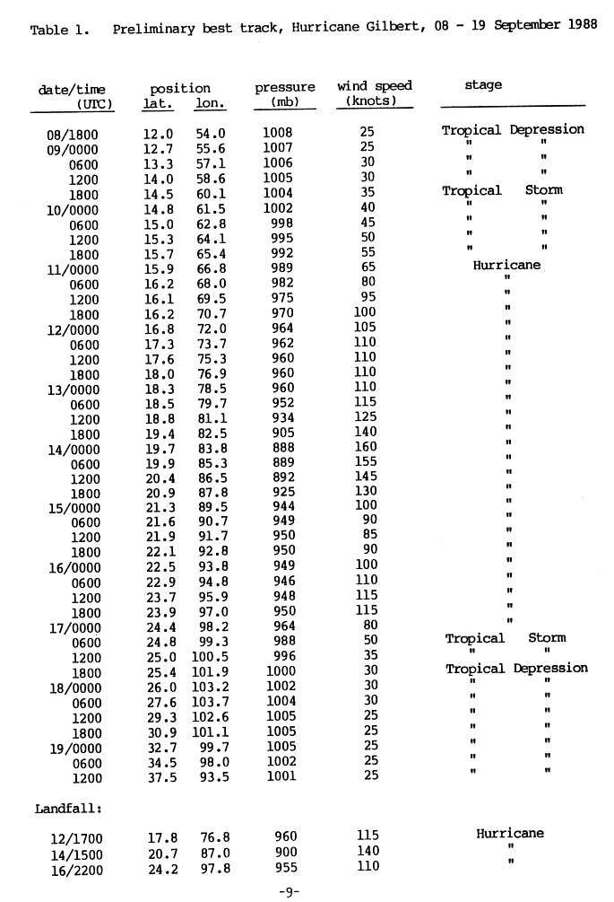
The origins of Hurricane Gilbert trace back to an easterly tropical wave—an elongated low-pressure area moving from east to west—that crossed the northwestern coast of Africa on September3, 1988. Over the subsequent days, the wave traversed the tropical Atlantic and developed a broad wind circulation extending just north of the equator. The system remained disorganized until September8, when satellite images showed a defined circulation center approaching the Windward Islands. The following day, the National Hurricane Center (NHC) classified it as the twelfth tropical depression of the annual hurricane season using the Dvorak technique, when it was located about 400mi (640km) east of Barbados. The depression proceeded toward the west-northwest, and while moving through the Lesser Antilles near Martinique, it gained enough strength to be designated as Tropical Storm Gilbert.[3]
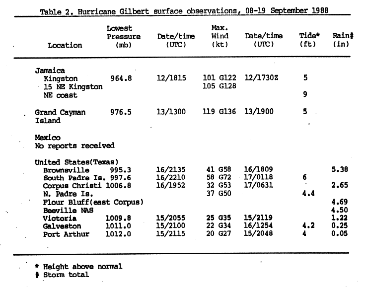
After becoming a tropical storm, Gilbert underwent a period of significant strengthening. Passing to the south of Dominican Republic and Haiti, it became a hurricane late on September10 and further strengthened to Category3 intensity on the Saffir–Simpson scale the next day. At that time, Gilbert was classified as a major hurricane with sustained winds of 130mph (210km/h) and a minimum barometric pressure of 960mbar (960hPa; 28inHg).[4] On September12, the hurricane made landfall on the eastern coast of Jamaica at this intensity; its 15mi (24km)-wide eye moved from east to west across the entire length of the island.[3][5]
Gilbert strengthened rapidly after emerging from the coast of Jamaica. As the hurricane brushed the Cayman Islands, a reporting station on Grand Cayman recorded a wind gust of 156mph (251km/h) as the storm passed just to the southeast on September 13. Explosive intensification continued until Gilbert reached a minimum pressure of 888mbar (888hPa; 26.2inHg) with maximum sustained flight-level winds of 185mph (298km/h), having intensified by 72mbar in a space of 24 hours.[nb 1][3] This pressure was the lowest ever observed in the Western Hemisphere and made Gilbert the most intense Atlantic hurricane on record until it was surpassed by Hurricane Wilma in 2005.[2]
Gilbert then weakened somewhat, but remained a Category5 hurricane as it made landfall for a second time on the island of Cozumel, and then a third time on Mexico's Yucatán Peninsula on September14.[3][7] This made it the first Category5 hurricane to make landfall in the Atlantic basin since Hurricane David hit Hispaniola in 1979. The minimum pressure at landfall in Cozumel was estimated to be 900 millibars (27inHg), along with maximum sustained winds of 160mph (260km/h).[7] The storm weakened quickly while crossing land before it emerged into the Gulf of Mexico as a Category2 hurricane.[8] Gilbert re-strengthened rapidly, however, and made landfall for a final time as a Category3 hurricane near La Pesca, Tamaulipas on September16, with winds of about 125mph (201km/h).[3]
On September17, Gilbert brushed the inland city of Monterrey, Nuevo León before taking a sharp turn to the north. The storm spawned 29 tornadoes in Texas on September18, and then moved across Oklahoma. It was absorbed by a low-pressure system over Missouri on September19, and finally became extratropical over Lake Michigan.[3]
Preparations
Hurricane Gilbert making landfall in Mexico on September 16.
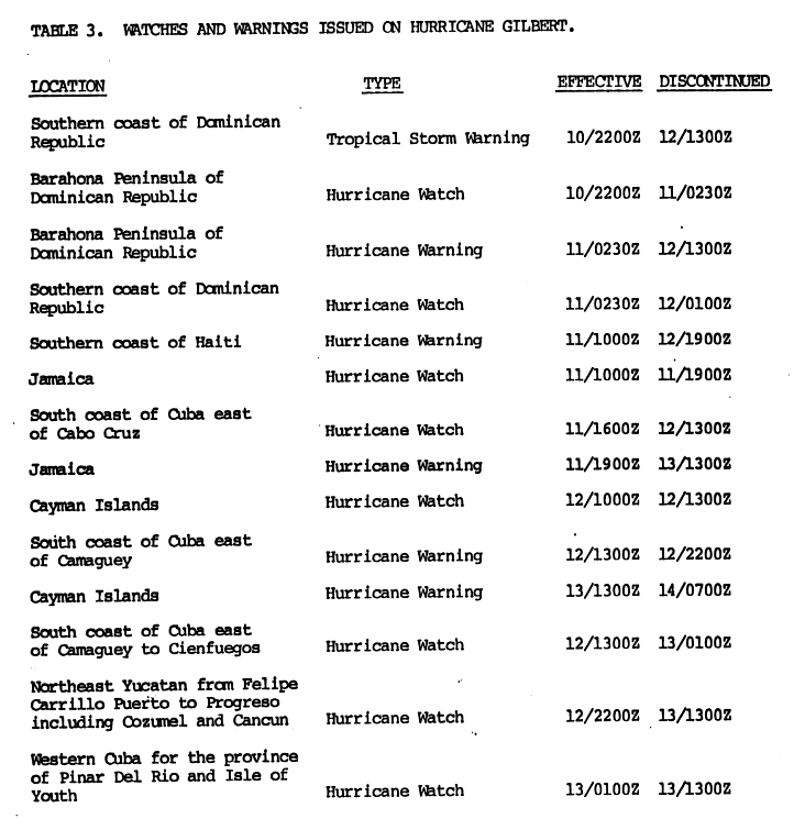
Late on September 10, a tropical storm warning was issued by the National Hurricane Center (NHC) for the southern coast of the Dominican Republic alongside a hurricane watch for the Barahona Peninsula. The hurricane watch for Barahona was upgraded to a hurricane warning early on September 11. Later that day, hurricane watches were posted for the Dominican Republic's southern coast, Jamaica, and the southern coast of Cuba east of Cabo Cruz; the hurricane watch in Jamaica was upgraded to a hurricane warning by the end of the day. Hurricane warnings for the southern coast of Haiti were also posted on September 11.[9]
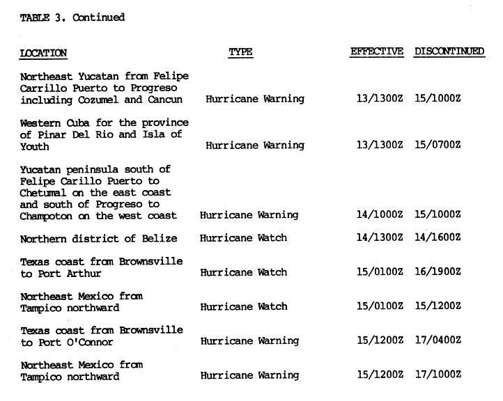
On September 12, a hurricane watch was issued for the Cayman Islands, and the hurricane watch for the southern coast of Cuba was extended to Cienfuegos, with the portion of the watch east of Camagüey upgraded to a hurricane warning. That evening, the Yucatán Peninsula was placed under a hurricane watch between Felipe Carrillo Puerto and Progreso. This area included the resort cities of Cancún and Cozumel.[9] The following day, hurricane watches were posted for Pinar del Río Province and Isla de la Juventud, and the Cayman Islands were placed under a hurricane warning.[9] The watches in western Cuba and the Yucatán Peninsula were replaced with warnings at about mid-day September 13.[10] As Gilbert approached the Yucatán Peninsula on September 14, the hurricane warning in the region was extended to cover the entire coast between Chetumal and Champotón, while a hurricane watch was posted for the northern district of Belize.[10] Once Gilbert entered the Gulf of Mexico on September 15, hurricane watches were posted for the portion of the shore between Port Arthur and Tampico. Around noon that day, the hurricane watch was upgraded to a hurricane warning between Tampico and Port O'Connor.[10]
The NHC advised small craft to remain in port in Puerto Rico and the United States Virgin Islands until weather conditions improved. Civil defense authorities in the Dominican Republic urged residents along the country's south coast to be prepared for strong winds, torrential rainfall, and rough seas.[11] Gilberto Gutierrez, the civil defense planning director, estimated that 100 to 200people fled their homes in the Barahona Peninsula.[12] In Cuba, a state of emergency was declared for Granma, Guantánamo, and Santiago de Cuba provinces. Approximately 90,000people in eastern Cuba evacuated from low-lying areas.[13] Another 60,000individuals fled their homes from low-lying areas of Pinar del Río Province and Isla de la Juventud. Some 4,000Red Cross volunteers assisted with evacuations and medical needs in Cuba.[14]Jamaican Prime MinisterEdward Seaga alerted other government officials about the approaching storm, including police and armed forces, and ordered that the National Arena be used as a shelter, which thousands of people stayed at. Around 100,000people evacuated from the Portmore area alone.[15] The threat from Gilbert led airports to cancel inbound commercial flights, while ferry services were suspended across Kingston Harbour.[16]
Cayman Airways evacuated residents from the Cayman Islands ahead of Gilbert.[17] Authorities in Mexico estimated that approximately 75,000people evacuated from parts of the Yucatán Peninsula, including tourists leaving resorts at places such as Cancún and Cozumel.[14] As Gilbert approached northeastern Mexico, 16shelters were opened in Matamoros, which sheltered roughly 55,000people. Another 100,000individuals moved farther inland.[18] Approximately 10,000oil workers left rigs in the Gulf of Mexico. In the United States, schools closed in some coastal counties of Texas and parishes of Louisiana. All naval ships along the Gulf Coast had "been ordered out to sea to ride out the storm", according to United Press International, while the naval air stations at Beeville and Corpus Christ were closed and their aircraft flown to Lackland Air Force Base near San Antonio. Around 25,000people evacuated in the latter,[19] including 15,000from southern Plaquemines Parish, 7,500from Cameron Parish, and 2,000from Grand Isle.[20]:35 Upwards of 170,000people fled their homes in Texas, with at least 113,000from Galveston County, due in part to an evacuation order of Galveston Island. South Padre Island and some neighborhoods of Brownsville were also ordered to evacuate. A total of 192Red Cross shelters opened across the state. Around 4,400state and county prisoners were moved inland.[19]Texas governorBill Clements issued a decree allowing municipalities to lift laws in the name of public safety, including contraflow lane reversals[21] and speed limits.[22]
Gilbert claimed 318 lives, mostly in Mexico. Exact monetary damage figures are not available, but the total for all areas affected by Gilbert is estimated to be near $2.98billion (1988 USD).
Eastern Caribbean and Venezuela
As a tropical storm, Gilbert brought high winds and heavy rains to many of the eastern Caribbean islands.[27] In St. Lucia, heavy rains peaking at 12.8in (330mm) in Castries resulted in flash flooding and mudslides, though no major structural damage was reported.[28][29] At Hewanorra International Airport, a dam ruptured and flooded one of the runways.[28] Offshore, six fishermen went missing as Gilbert approached the Lesser Antilles.[29] Banana crop losses from the storm in St. Lucia reached $740,000, with Guadeloupe, St. Vincent, and Dominica reporting similar damage.[27] Several mudslides were reported in Dominica, though no damage resulted from them. Roughly 5in (130mm) of rain fell in Barbados, leading to flash floods and prompting officials to close schools and government offices.[28] The U.S. Virgin Islands experienced widespread power outages and flooding, with many residents losing electricity for several days. Damage was less severe in the nearby British Virgin Islands, where only some flooding and power outages took place. In Puerto Rico, dozens of small communities lost power and agricultural losses reached $200,000.[27]
In Venezuela, outflow bands from Gilbert produced torrential rain which triggered widespread flash floods and landslides in the northern part of the country, killing five people and leaving hundreds homeless.[23][30] Damage from the storm was estimated at $3million.[31] In total, seven fatalities would occur in the Dominican Republic and Venezuela.[32]
Hispaniola
Heavy rains from the outer bands of Hurricane Gilbert triggered significant flooding in the Dominican Republic and Haiti. At least nine people perished in the Dominican Republic as many rivers, including the Yuna, overtopped their banks.[25] The main electrical relay station in Santo Domingo was damaged by the storm, causing a temporary blackout for much of the city.[33] Losses in the country were estimated in the millions of dollars.[25] In nearby Haiti, more substantial losses took place; 53 people died,[24] including 10 offshore. Most of the casualties took place in the southern part of the country. The port of Jacmel was reportedly destroyed by 10ft (3.0m) waves stirred up by the hurricane.[25] In light of extensive damage, the government of Haiti declared a state of emergency for the entire southern peninsula.[33] Losses throughout Haiti were estimated at $91.2million.[24]
Jamaica
Gilbert approaching Jamaica on September 12
Hurricane Gilbert produced a 19ft (5.8m)storm surge and up to 32.4 inches (823mm) of rain in the mountainous areas of Jamaica,[34] causing inland flash flooding.[23] An observation site located about 15 miles (24km) northeast of Kingston recorded sustained winds of 121mph (195km/h) and wind gusts up to 147mph (237km/h). At least 45people died.[23] Prime Minister Edward Seaga stated that the hardest hit areas near where Gilbert made landfall looked "like Hiroshima after the atom bomb."[35] The storm left at least $800million (1988USD) in damage from destroyed crops, buildings, houses, roads, and small aircraft, according to the National Library of Jamaica.[36] However, other sources such as the Monthly Weather Review and the National Hurricane Center estimated that Gilbert caused almost $2billion in damage in the country.[7][23] Additionally, the Regional Disaster Information Centre placed the damage total at $4billion, with agricultural impacts representing more than 40% of this figure.[5] Seaga initially stated that damage reached about $8billion, but later lowered his estimate to $818million to $1billion while speaking to Parliament.[37] Regardless, Gilbert was one of the most destructive storms in the history of Jamaica and the most severe storm since Hurricane Charlie in 1951.[38]
Seaga described a few districts of Portland and Saint Thomas parishes as completely devastated and reported heavy damage in Hanover, Saint Catherine, and Westmoreland parishes, including the destruction of hundreds of acres of sugarcane and coconut groves.[39] Estimates of property damage by September13 reached over $200million. A breakdown of the $818million damage estimate, reported to the Office of the United Nations Disaster Relief Coordinator (UNDRO) by October11, included $260million incurred to low income dwellings, $179million to agriculture and farming, $106million to electrical utilities, $89million to educational institutes, $60million to fishing and forestry industries, $46million to factories and hotels, $37million to transportation and drainage infrastructure, $16million to government buildings, $14million to healthcare facilities, and $11million to waterworks.[40]
Buildings destroyed after Hurricane Gilbert
Government officials initially estimated approximately 100,000homes were demolished and another 300,000suffered severe damage or lost their roof, with around 500,000people, roughly 20% of the population of Jamaica, becoming homeless.[39] However, Jamaican Information Services Director Jean Lewis noted in October that officials believed that figure was exaggerated.[37] The report to UNDRO listed 229,300low income housing units as damaged and another 10,300as destroyed.[40]Reconnaissance flights over remote parts of Jamaica reported that 80% of the homes on the island had lost their roofs.[38]
More than 50% of National Water Commission facilities suffered some degree of damage. Only one water treatment plant remained fully functional following the storm. Around 95% of health facilities experienced structural impacts, with over half (55%) being substantially damaged and two hospitals destroyed.[5] Gilbert damaged at least 85% of schools.[41] The country's banana crop and poultry industry were also virtually wiped out.[42][38] Hundreds of miles of roads and highways were also heavily damaged.[42] Two people eventually had to be rescued because of mudslides triggered by Gilbert and were sent to the hospital. The two people were reported to be fine. No planes were going in and out of Kingston, and telephone lines were jammed from Jamaica.[17] As Gilbert lashed Kingston, its winds knocked down power lines, uprooted trees, and flattened fences. On the north coast, 20 feet (6.1m) waves hit, forcing hotels to be evacuated in the popular tourist destination. Kingston's airport reported severe damage to its aircraft, and all Jamaica-bound flights were cancelled at Miami International Airport.[17]
Cayman Islands
Gilbert passed 30 miles (48km) to the south of the Cayman Islands early on September 13, with one reported gust of 157mph (253km/h). However, the islands largely escaped the hurricane due to Gilbert's quick forward motion. Damage was mitigated because the depth of the water surrounding the islands limited the height of the storm surge to 5ft (1.5m) There was very severe damage to crops, trees, pastures, and a number of private homes.[43] At least 50 people were left homeless and losses were expected to be in the millions.[25]
Across parts of northern Central America, heavy rains from the outer bands of Hurricane Gilbert triggered deadly flash floods. Its rainfall and high winds reached Guatemala, Belize, and Honduras. In Honduras, at least eight people were killed and 6,000 were left homeless. Additionally, approximately 27,000 acres (11,000 hectares) of crops were flooded.[44] Sixteen people perished in Guatemala and another five died in Nicaragua, leaving a total of 21 people dead in Central America.[45]
Mexico
Most intense landfalling Atlantic hurricanes Intensity is measured solely by central pressure
Rainfall in the United States and Mexico from Gilbert
Although no wind observations were available from Mexico,[3] Gilbert may have produced wind gusts up to 200mph (320km/h) in the Yucatán Peninsula,[49] which the storm struck as a Category5 hurricane.[2] Rainfall in Mexico peaked at 13.78 inches (350mm) in Progreso, Yucatán.[50] The NHC noted that the Yucatán Peninsula likely had storm surge ranging from 15 to 20ft (4.6 to 6.1m) above ground near and north of where the hurricane made landfall, although Esmas.com reported a peak of around 23ft (7m). The east coast of Mexico experienced storm surge totals from 8 to 13ft (2.4 to 4.0m) above ground around and just north of the point where Gilbert struck the country again.[7] Gilbert destroyed approximately 60,000homes in Mexico.[51] Overall, the hurricane caused 202deaths and approximately $2billion in damage.[23]
In the Yucatán Peninsula, more than 5,000 American tourists were evacuated from Cancún.[52] Storm surge washed away 60% of the city's beaches and penetrated up to 3.1mi (5km) inland.[53] A local official estimated that Gilbert demolished and substantially damaged approximately 80% of palapas, a type of structure that roughly 60% of residents live in.[54]:78 Many public schools being used as shelters flooded.[54]:76 Three ferries used for transportation between Isla Mujeres and the mainland capsized.[55] In Quintana Roo, Gilbert caused significant defoliation in the jungle. The debris eventually fueled a fire in 1989, which ultimately burned 460sqmi (1,200km2).[56] Quintana Roo Governor Miguel Borge reported that damages in Cancún were estimated at more than 1.3billion Mexican pesos (1988 pesos; $500million in USD). A further loss of $87million (1989USD) due to a decline in tourism was estimated for the months of October, November and December in 1988.[54]:69 Damage to the vegetation of Cozumel Island combined with human habitat alteration is blamed for the rapid decline and possible extinction of the endemic Cozumel Thrasher.
Strong winds in the state of Yucatán littered the streets with hundreds of tree branches and pieces of corrugated tin roofs. Additionally, high tensions towers crashed on to a highway from Mérida to Valladolid and a number of electrical and telephone lines were downed, almost completely severing communications from the state. In Valladolid, the hurricane destroyed dozens of homes.[49] Four deaths occurred in Dzidzantún when a wall collapsed. Many residents throughout the state lost electrical and water services.[49] In Campeche, an employee of the newspaper Novedades de Campeche remarked that "there is no light, there is no radio ... The whole city is flooded." Gilbert also downed many trees and tossed boats up to hundreds of yards inland. Two infants drowned while residents evacuated from a low-lying neighborhood.[55]
As Gilbert lashed the third largest city of Mexico, Monterrey, it brought very high winds, torrential rains, and extensive flash floods. More than 60 people died from raging flood waters, and it was feared that more than 150 people died when five buses carrying evacuees were overturned in the raging floodwaters. Six policemen died when they were swept away while trying to rescue passengers on buses stranded by the Santa Catarina River.[51][52] The residents of Monterrey had no power or drinking water, and most telephone lines were down. As the water receded, vehicles began appearing with their wheels up, jammed with mud and rocks.
In Saltillo, five people died in road accidents caused by heavy rain, and almost 1,000 were left homeless.[52] Rainfall in northeastern Mexico peaked at over 10 inches (250mm) in localized areas of inland Tamaulipas.[50] In Coahuila, rainfall from Gilbert caused the deaths of 5 people who were swept away by rising waters. Among these were a paramedic and a pregnant woman who died when a Mexican Red Cross ambulance fell into a flooded arroyo near Los Chorros after a bridge collapsed.[57] Gilbert dumped torrential rains and spawned some tornadoes.[58]
United States
Gilbert caused three deaths and approximately $80million in damage in the United States,[23][26] mostly in south Texas.[23] According to Storm Data, the cyclone spawned 47tornadoes, including 41in Texas, 3in Alabama, 2in Mississippi, and 1each in Louisiana and Oklahoma.[20]:28 In Florida, abnormally high tides flooded streets in Key West,[59] where a thunderstorm associated with Gilbert produced wind gusts as high as 58mph (93km/h).[60] All three tornadoes spawned in Alabama uprooted trees, while one also toppled permanent signs in Daleville.[20]:30 In Mississippi, a tornado deroofed a home near Waveland and another damaged a roof and a car in Moss Point.[20]:36 Tides generally 2ft (0.61m) above normal impacted Louisiana east of the Mississippi River and 2 to 4ft (0.61 to 1.22m) above normal west of the river. Some roads near bayous in southern Terrebonne Parish flooded, while up to 60ft (18m) of beachfront was lost at parts of Grand Isle.[20]:35 An F0 tornado in Lacombe caused slight damage to a commercial building and ripped branches from trees.[61]
Oklahoma recorded the highest rainfall in the United States at 8.6 inches (220mm), in Wichita Mountains Wildlife Refuge.[50] Isolated locations in Texas and Oklahoma reported over 7 inches (180mm).[50] In the latter, nearly 100people in the city of Kingfisher after Kingfisher Creek overflowed its banks. A tornado touched-down in Ottawa County, impacting two barns and crossing Ottawa Indian Cemetery, where it destroyed a small building and damaged 20tombstones.[20]:39 Up to 3 inches (76mm) fell in central Michigan.[50]
Texas
Despite concerns that Texas might suffer a direct hit,[19] Gilbert made landfall about 120mi (190km) south of the border.[2] Consequently, a few locations observed sustained tropical storm-force winds, peaking at 67mph (108km/h) at South Padre Island, which also recorded the strongest wind gust, 83mph (134km/h). Tides also reached 6ft (1.8m) above normal, also the highest reported.[62] According to the Weather Prediction Center, rainfall in Texas peaked at 7.45in (189mm) in Anson,[63] although Storm Data noted that 8.71in (221mm) of precipitation fell in Lamar. While some places experienced flash flooding, rainfall in Texas was generally beneficial.[20]:42 Gilbert also spawned 41tornadoes in the state.[20]:28
Winds in coastal south Texas downed some trees and a few power poles and caused minor crop losses. However, a floating marina at Port Isabel experienced major damage.[20]:42 Gilbert spawned at least 29tornadoes in south Texas.[23] In Cameron County, a tornado near the northside of Brownsville inflicted severe damage to homes and apartment complexes and another twister moved across Harlingen, damaging 20to30car windshields and some roofs, shattering windows at a hospital and nearby residences, and collapsing a wall and roof of a doctors office, with damage totaling at least $1million. Several tornadoes touched-down in neighboring Hidalgo County. Although nearly all of them resulted in little to no impact, one toppled many trees, substantially damaged the roofs of some residences, and destroyed a home, a church, and least one mobile home.[20]:42
In the Corpus Christi area, storm surge and abnormally high tides inundated coastal roads and the John F. Kennedy Memorial Causeway, which was temporarily closed. Three tornadoes were spawned in Nueces County, one downing many trees; another damaging some fences, signs, and trees; and a third damaged some buildings at Naval Air Station Corpus Christi and residences at a nearby unoccupied housing development. A tornado in Pettus destroyed a municipal waterworks, two mobile homes, and some outbuildings. In neighboring Karnes County, a twister demolished a shed and chain-link fence and caused slight damage to a dwelling.[20]:42 A tornado spawned by Gilbert in Fayette County deroofed some barns and outbuildings and uprooted at least 15trees and another in Caldwell County also toppled trees. In Comal County, a tornado deroofed a mobile home and inflicted minor roof damage to some homes.[20]:43 A 3-year-old girl drowned near Port Lavaca.[64] Minor coastal flooding occurred in the Greater Houston area.[20]:42
Three tornadoes touched-down in Bexar County, home of San Antonio, with each causing structural impacts. The first downed many trees and destroyed nine homes and five mobile homes over the southside of the county, injuring one person and killing another.[20]:42 Next, a twister crossed Kelly Air Force Base and continued on the ground for 2mi (3.2km), demolishing 2warehouses and severely damaging about 12others, damaging at least 20vehicles, and injuring 18people. Damage from this tornado totaled about $28million. The third tornado damaged roughly 500vehicles, 173homes – 78severely – partly deroofed a supermarket, and shattered windows at an apartment building and hospitals, with the Audie L. Murphy Memorial VA Hospital also suffering major roof damage. Overall, this twister caused approximately $6million in damage.[20]:43 A second person died in Bexar County after winds snapped an electrical pole, which crashed through the window of a home.[65]
In Val Verde County, four tornadoes touched-down.[66] Although two inflicted no impacts, one damaged some outbuildings near Comstock and another along the northside of Del Rio severely damaged 89homes, 15to20cars, and a marina on Lake Amistad, and destroyed 18residences, while several mobile homes experienced either substantial damage or were demolished.[20]:43 Damage from the Del Rio tornado totaled about $2.5million.[67] Gilbert dropped 4 to 5in (100 to 130mm) of rain over Val Verde County, causing the Devils and Pecos rivers to overflow. Floodwaters inundated the Texas State Highway 163 bridge, leading to its closure. Concho County reported six tornadoes, although only one rendered any impacts, limited to minorly damaging a barn and toppling several trees on the west end of Eden.[20]:43Downbursts relating to Gilbert affected the northside of the Dallas–Fort Worth metropolitan area. A downburst in Collin County nearly destroyed a hardware and lumber store, flattened several dwellings that were under construction, damaged the roof of a home, and tossed several cars. In Denton County, a downburst that produced wind gusts up to 70mph (110km/h) downed power lines in Valley View.[20]:41
Aftermath
Wettest tropical cyclones and their remnants in Jamaica Highest-known totals
The overall property damage was estimated at $2.98billion (1988 USD). Earlier estimates put property damage from Gilbert at $2.5billion but were as high as $10billion. A final count of Hurricane Gilbert's victims is not possible because many people remained missing in Mexico, but the total confirmed death toll was 433 people.[76]
Relief efforts
Partners of the Americas, a coalition of 60countries, established a special relief fund for Jamaica and Mexico. Red Cross chapters in the British and United States Virgin Islands solicited monetary contributions, which they used to purchase supplies such as batteries, candles, baby food, canned food, and flashlights.[39] In Texas, a major disaster was declared on October 5, 1988, which included Bexar, Cameron, and Hidalgo counties.[77]
The government of Haiti requested that the Office of the United Nations Disaster Relief Coordinator issue an appeal for international aid due to heavy damage in the southern parts of the country. The Armed Forces conducted damage and needs surveys. By October10, the governments of Canada, France, and Switzerland each donated more than $30,000, while Catholic Relief Services expended just over $111,000 in aid and CARE International contributed thousands of bottles of oil and bags of milk and wheat.[78]
Jamaica
Jampress stated that Edward Seaga, Prime Minister of Jamaica, described shelters in Kingston as appearing to have adequate supplies, but that food should be airlifted to inland communities left isolated due to impassible roads. Within a few days of Gilbert's landfall, Seaga viewed damage across Jamaica with U.S. AmbassadorMichael G. Sotirhos and United States Agency for International Development (USAID) director William Joslyn. United States Navy cargo planes quickly sent water storage tanks and roof covering made of plastic. Additionally, USAID donated relief supplies with a monetary value of nearly $400,000, including 9,600blankets, almost 4,000water jugs, 360plastic sheeting rolls, 200tents, 18water tanks, and 10chain saws. On September15, the European Economic Community (EEC) agreed to allocate $728,000 to Jamaica. The EEC also announced their intentions to send an initial shipment of about 16,000blankets and 500plastic rolls via the British Red Cross.[39]
The government enacted a curfew in Kingston via the Suppression of Crimes Act. Incidents of looting were reported in the aftermath of the storm, especially at grocery stores and supermarkets, with the total value of stolen items exceeding J$51.2million. Police subsequently recovered approximately J$2.5million worth of goods.[36]
On January15, 1989, Seaga called the next general election to be held on February9, allowing for the shortest possible time for campaigning.[79] Although a Market Research Services Ltd. poll from November25 to December2, 1988, noted that 53% of respondents favored Seaga handling recovery efforts versus 38% for opposition leader Michael Manley, election polls around that time indicated that Manley's People's National Party lead Seaga's Jamaica Labour Party by a margin of about 10%.[80] Most candidates for the election inspected damage on the island and vigorously participated in relief efforts.[81]
Records
On September13, Hurricane Gilbert attained a record low central pressure of 888mb (hPa; 26.22inHg), surpassing the previous minimum of 892hPa (26.34inHg) set by the 1935 Labor Day hurricane. This made it the strongest tropical cyclone on record in the north Atlantic basin at the time. It was surpassed by Hurricane Wilma in 2005, which attained a central pressure of 882hPa (26.05inHg).[2] Gilbert was the most intense tropical cyclone on record to strike Jamaica until it was surpassed 37 years later by Hurricane Melissa with a wind speed of 185 mph and a pressure of 892 mbar. The storm also produced record-breaking rainfall in Jamaica, amounting to 27.56in (700mm). This ranked it (at that time) as the fourth-wettest known storm to strike Jamaica.[23]
Due to the extensive damage and loss of life from the hurricane, the name Gilbert was retired by the World Meteorological Organization following the 1988 season, and will never again be used for another Atlantic hurricane.[82][83] It was replaced by Gordon for the 1994 season.[84]
Popular culture
In Jamaica, dance hall DJ Lovindeer released a single called "Wild Gilbert" a few days after the storm. It was the fastest selling reggae record in the history of Jamaican music.[85] In 1989, the PBS series Nova released the episode "Hurricane!" that featured Gilbert (later modified in 1992 to reflect Hurricane Andrew and Hurricane Iniki).[citation needed]
↑US Department of Commerce, NOAA. "Hurricane Gilbert 1988". www.weather.gov. Retrieved October 27, 2025.
123The Hurricane and its Effects: Hurricane Gilbert - Jamaica(PDF). Pan American Health Organization Emergency Preparedness and Disaster Relief Coordination Program (Report). Centro Regional de Información sobre Desastres América Latina y El Caribe. February 20, 1999. Archived from the original(PDF) on February 22, 2012. Retrieved March 4, 2012.
↑"Gilbert hammers Jamaica". The Bulletin. Bend, Oregon. United Press International. September 12, 1988. p.1. Retrieved October 28, 2025– via Newspapers.com.
↑Wiliams, Lloyd (September 12, 1988). "Hurricane Gilbert Homes In On Jamaica". Vicksburg Evening Post. Associated Press. p.A10. Retrieved October 28, 2025– via Newspapers.com.
12345"Hurricane Gilbert's swathe of death and disaster". United Press International. New York, United States: The Independent. September 19, 1988. p.10. (accessed through LexisNexis)
↑Reyna, Patrick (September 14, 1988). "Jamaica's Premier Reports Island Devastated by Hurricane". Kingston, Jamaica. Associated Press. (accessed through LexisNexis)
↑Rossie. Cam (September 16, 1988). "Thousands Left Homeless By Hurricane Gilbert; Makes Landfall In Mexico". Matamoros, Mexico. Associated Press. (accessed through LexisNexis)
↑"Gilbert leaves big toll". Sunday Herald Sun. Melbourne, Australia. Reuters. September 19, 1988. (accessed through LexisNexis)
↑Markowitz, Arnold (September 14, 1988). "Gilbert grows into monster". Miami Herald. p.19A. Retrieved October 26, 2025– via Newspapers.com.
↑"Hurricane Brings Rain To Key West". The Daily Progress. Charlottesville, Virginia. September 14, 1988. p.A12. Retrieved October 26, 2025– via Newspapers.com.
↑Event Details: Tornado (Report). National Centers for Environmental Information. Retrieved October 31, 2025.
↑Paulhaus, J. L. H. (1973). World Meteorological Organization Operational Hydrology Report No. 1: Manual For Estimation of Probable Maximum Precipitation. World Meteorological Organization. p.178.
12Evans, C. J.; Royal Meteorological Society (1975). "Heavy rainfall in Jamaica associated with Hurricane Flora 1963 and Tropical Storm Gilda 1973". Weather. 30 (5). Blackwell Publishing Ltd: 157–161. doi:10.1002/j.1477-8696.1975.tb03360.x. ISSN1477-8696.
↑Blake, Eric S.; National Hurricane Center (March 7, 2011). Tropical Storm Nicole(PDF) (Tropical Cyclone Report). United States National Oceanic and Atmospheric Administration's National Weather Service. Retrieved May 13, 2012.
↑Pasch, Richard J; Reinhart, Brad J; Berg, Robbie; Roberts, David P (June 9, 2021). Tropical Cyclone Report: Hurricane Eta(PDF) (Report). United States National Hurricane Center. Archived(PDF) from the original on February 15, 2024. Retrieved May 21, 2024.
↑Stewart, Stacey R. (December 16, 2004). Hurricane Ivan (Tropical Cyclone Report). United States National Hurricane Center. Retrieved May 13, 2012.
↑Blake, Eric S; Kimberlain, Todd B; Berg, Robert J; Cangialosi, John P; Beven II, John L (February 12, 2013). Hurricane Sandy: October 22– 29, 2012(PDF) (Tropical Cyclone Report). United States National Hurricane Center. Archived(PDF) from the original on May 18, 2024. Retrieved January 29, 2014.
↑Kurlanksky, Mark (November 27, 1988). "Seaga vs. Manley: Final showdown looms". The Gazette. Montreal, Quebec. The New York Times Magazine. p.B-5. Retrieved October 27, 2025– via Newspapers.com.
↑National Hurricane Operations Plan(PDF) (Report). Washington, D.C.: NOAA Office of the Federal Coordinator for Meteorological Services and Supporting Research. May 1994. p.3-7. Retrieved April 5, 2024.
↑Barker, David; Miller, David (1990). "Hurricane Gilbert: anthropomorphising a natural disaster". Area. 22 (2): 107–116. JSTOR20002812.
This page is based on this Wikipedia article Text is available under the CC BY-SA 4.0 license; additional terms may apply. Images, videos and audio are available under their respective licenses.


