Tropical Storm Chris (1988)

Last updated

Map key
  Tropical depression (≤38 mph, ≤62 km/h)
  Tropical storm (39–73 mph, 63–118 km/h)
  Category 1 (74–95 mph, 119–153 km/h)
  Category 2 (96–110 mph, 154–177 km/h)
  Category 3 (111–129 mph, 178–208 km/h)
  Category 4 (130–156 mph, 209–251 km/h)
  Category 5 (≥157 mph, ≥252 km/h)
  Unknown
Storm type
Disc Plain black.svg Tropical cyclone
Solid black.svg Subtropical cyclone
ArrowUp.svg Extratropical cyclone, remnant low, tropical disturbance, or monsoon depression

A tropical wave emerged into the Atlantic from the west coast of Africa on August 15. Six days later, the system developed into Tropical Depression Seven while centered halfway between the Lesser Antilles and Africa. The depression tracked west-northwestward around the periphery of a subtropical surface high pressure ridge. After strengthening minimally, the depression struck Guadeloupe late on August 23 and entered the Caribbean Sea shortly thereafter. Although satellite intensity estimates indicated tropical storm status, 13 reconnaissance flights conducted by the National Hurricane Center between August 23 and August 27 indicated winds were less than 40 mph (64 km/h). By August 25, the depression made landfall near Santo Domingo, Dominican Republic. Despite the mountainous terrain of Hispaniola, the depression did not weaken and re-emerged into the Atlantic from the northern coast of Haiti early on August 26. The depression curved northwestward and did not strengthen. On August 27, the depression made another landfall near Andros Town on Andros, Bahamas. Later that day, the depression passed less than 25 miles (40 km) east of West Palm Beach, Florida. Thereafter, the depression curved north-northwestward and remained offshore of Florida. [1]

At 0600 UTC on August 28, a ship located about 93 miles (150 km) from the center of the depression reported tropical storm force winds. As a result, the depression was finally upgraded to Tropical Storm Chris. Tracking rapidly north-northeastward, Chris attained its peak intensity about six hours later, with maximum sustained winds of 50 mph (80 km/h) and a minimum barometric pressure of 1,005  mbar (29.7  inHg ). The storm made its final landfall near Savannah, Georgia with winds of 45 mph (72 km/h) at 1500 UTC on August 28. After moving inland, Chris quickly weakened and was downgraded to a tropical depression near Columbia, South Carolina on August 29. Shortly thereafter, Chris merged with a cold front over North Carolina. The remnants of Chris tracked east-northeastward across the Eastern United States. Eventually, the remnants briefly re-emerged into the Atlantic from New England, then moved across Nova Scotia before dissipating near Cape Breton Island on August 30. [1]

Preparations

In preparation of the tropical depression, officials in Puerto Rico closed public schools and sent federal workers home early. [2] At 1000 UTC on August 28, a tropical storm watch was issued for Edisto Beach, South Carolina, to Cape Hatteras, North Carolina. Two hours later, areas from Savannah, Georgia, to Cape Hatteras North Carolina, were placed under a tropical storm warning. They were later discontinued at an unknown time. [1] Residents of Charleston, South Carolina, complained of little warning in advance of the storm. [3] However, as Chris moved ashore only nine hours after becoming a tropical storm, there was minimal time for preparations. [1]

Impact

Rainfall totals in Puerto Rico. Chris 1998 Puerto Rico rainfall.gif
Rainfall totals in Puerto Rico.

Lesser and Greater Antilles

In the United States Virgin Islands, the depression dropped 1 inch (25 mm) of rain. Precipitation on the island of Puerto Rico was generally between 3 and 7 inches (76 and 178 mm), with a peak total of 14.5 inches (370 mm) in Hacienda Constanza. [4] Heavy rainfall resulting in flooding, which damaged at least 100 homes [5] and left 485 people homeless. [6] By August 24, at least 15 people evacuated their homes because of flooding. Due to high winds, two cars were crushed by falling trees, causing the deaths of two men and one 12-year-old boy. [6] Hispaniola received heavy rain and 35 mph (56 km/h) winds but no deaths or damage was reported. In the Bahamas, the storm brought winds of 35 mph (56 km/h) but left no damage. [7]

United States

Rainfall totals from Tropical Storm Chris. Chris 1988 rainfall.gif
Rainfall totals from Tropical Storm Chris.

The outer bands of Chris produced 1–3 inches (25–76 mm) of rain in Florida, though no damage was reported. [4] At Fort Pulaski National Monument in Georgia, tides were 1.5 feet (0.46 m) above normal. In that state, Chris produced a sustained wind speed of 43 mph (69 km/h) at Savannah Light, though it was at an elevation of 70 feet (21 m). In addition, the highest wind gust was reported at that location, reaching up to 49 mph (79 km/h). Elsewhere in Georgia, winds were light and were below tropical storm force. [8] Rainfall in the state was mostly less than 2 inches (51 mm), [4] with a peak of 2.01 inches (51 mm) in southeastern Georgia. [9]

Along the coast of South Carolina, tides of at least 0.2 and 0.3 feet (0.061 and 0.091 m) above normal were reported at Charleston and Myrtle Beach, respectively. [10] However, the Preliminary Report on Tropical Storm Chris indicates tides of 0.5 feet (0.15 m) at Charleston and 1 foot (0.30 m) above normal at Myrtle Beach. [8] Several tornadoes were spawned in the state, one of which caused one fatality, one injury, and destroyed at least 15 mobile homes in Clarendon County. [11] Overall, tornadoes in the state collectively resulted in more than $550,000 in damage (1988 USD). [12] Debris littered U.S. Route 301, which briefly shutdown that highway. Winds were relatively light in the state, with sustained winds generally less than 30 mph (48 km/h) and gusts to 44 mph (71 km/h) were reported in Charleston. However, 18,000 people in Charleston and other nearby communities lost electricity. In addition, one mobile home was destroyed and another was overturned in Olanta. [13] Rainfall in South Carolina was generally between 1 and 5 inches (25 and 127 mm), though peaking at 7.64 inches (194 mm) in Bishopville. Near Columbia, 1.72 inches (44 mm) of rain fell in only an hour, leaving standing water on several roads, including Interstate 26. [14]

In North Carolina, a tornado spawned in Iredell County threw a tractor-trailer into a building at an industrial park. The tornado also struck the Iredell Container Corp. building and damaged several nearby mobile homes. As a result, numerous residents of Iredell County were left without gas or electricity. Four houses and a produce stand were destroyed by another tornado along U.S. Route 401 in Cumberland County. [15] A third tornado in Granville County caused one injury and light damage. [12] Collectively, the three tornadoes in the state caused at least $1 million (1988 USD) in damage. [15] In Charlotte, a wind gust of 42 mph (68 km/h) was reported, which downed power lines and damaged the facade of a hotel. [16]

In Mecklenburg County, Virginia, an F2 tornado spawned near Chase City damaged or destroyed ten buildings, including a mobile home, which was wrapped completely around a tree. Additionally, several vehicles were damaged and one injury occurred. Damage from that tornado reached about $700,000 (1988 USD). [12] Winds in Washington D.C. reached slightly more than 47 mph (76 km/h), leaving 3,800 homes without electricity. [12] [17] In Maryland, rainfall was less than 2 inches (51 mm) at all locations. A wind gust reaching 55 mph (89 km/h) was reported in Baltimore, though sustained winds were below tropical storm force. Similar amounts of rainfall occurred in other nearby states such as Delaware, New Jersey, and Pennsylvania; minor creek flooding occurred in those three states. In Wilmington, Delaware, a wind gust of 48 mph (77 km/h) was reported. Power lines were snapped in Essex County, New Jersey. [17]

The storm downed power lines on Staten Island and Long Island in New York, leaving 31,000 people without power. However, many had their electricity restored within 24 hours. A woman was killed in Mamaroneck when an oak tree fell on her car. According to New York City Transit officials, trees also fell on tracks, which slowed transportation services during rush hour. [18] Two other fatalities when two people canoed in the Highland Falls Reservoir; high winds tipped their canoe and both people subsequently drowned. Wind gusts up to 40 mph (64 km/h) in Rhode Island caused scattered power outages and minor property damage, due to falling tree limbs. In Connecticut, gusty winds felled trees, which struck power lines, leaving at least 59,000 people without electricity. [12] High winds in Maine from the storm damaged power lines, leaving 10,000 people without electricity. The storm also damaged four houses and several automobiles near Crystal Lake. [12] Throughout the United States, damaged totaled to at least $2.25 million (1988 USD). [12] [15]

Canada

The extratropical remnants of Chris dropped heavy rains and produced winds of 25–30 mph (40–48 km/h). There were no reports of damage. [19]

See also

Related Research Articles

<span class="mw-page-title-main">1998 Atlantic hurricane season</span> Hurricane season in the Atlantic Ocean

The 1998 Atlantic hurricane season was one of the most disastrous Atlantic hurricane seasons on record, featuring the highest number of storm-related fatalities in over 218 years and one of the costliest ever at the time. The season had above average activity, due to the dissipation of the El Niño event and transition to La Niña conditions. It officially began on June 1 and ended on November 30, dates which conventionally delimit the period during which most tropical cyclones form in the Atlantic Ocean. The season had a rather slow start, with no tropical cyclones forming in June. The first tropical cyclone, Tropical Storm Alex, developed on July 27, and the season's final storm, Hurricane Nicole, became extratropical on December 1.

<span class="mw-page-title-main">1959 Atlantic hurricane season</span> Hurricane season in the Atlantic Ocean

The 1959 Atlantic hurricane season featured near normal tropical cyclone activity overall. The season officially began on June 15, 1959 and lasted until November 15, 1959. These dates historically described the period in each year when most tropical cyclogenesis occurs in the Atlantic basin. However, the formation of a tropical cyclone is possible at any time of the year, as shown in 1959, by the formation of Tropical Storm Arlene on May 28. Arlene struck Louisiana and brought minor flooding to the Gulf Coast of the United States. The next tropical storm, Beulah, formed in the western Gulf of Mexico and brought negligible impact to Mexico and Texas. Later in June, an unnamed hurricane, caused minor damage in Florida, and then devastated parts of Maritime Canada, resulting in what became known as the Escuminac disaster. Hurricane Cindy brought minor impact to The Carolinas. In late July, Hurricane Debra produced flooding in the state of Texas. Tropical Storm Edith in August and Hurricane Flora in September caused negligible impact on land.
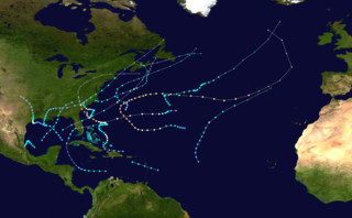
<span class="mw-page-title-main">1961 Atlantic hurricane season</span> Hurricane season in the Atlantic Ocean

The 1961 Atlantic hurricane season was a hyperactive Atlantic hurricane season, with an accumulated cyclone energy (ACE) total of 189. The season, however, was an average one in terms of named storms. The season featured eight hurricanes and a well above average number of five major hurricanes. It was previously thought that the season had a record-tying seven major hurricanes, before the Atlantic hurricane reanalysis project downgraded two storms in 2019. Two Category 5 hurricanes were seen in 1961, making it one of only seven Atlantic hurricane seasons to feature multiple Category 5 hurricanes in one season. The season started on June 15, and ended on November 15. These dates conventionally delimit the period of each year when most tropical cyclones form in the Atlantic basin. The first system, an operationally unclassified tropical depression, formed offshore east Central Florida on June 10, but dissipated a few days later. Next, Hurricane Anna developed in the eastern Caribbean Sea near the Windward Islands on July 20. It brought minor damage to the islands, as well as wind and flood impacts to Central America after striking Belize as a hurricane. Anna caused one death and about $300,000 (1961 USD) in damage. Activity went dormant for nearly a month and a half, until Hurricane Betsy developed on September 2. Betsy peaked as a Category 4 hurricane, but remained at sea and caused no impact.

<span class="mw-page-title-main">1977 Atlantic hurricane season</span> Hurricane season in the Atlantic Ocean

The 1977 Atlantic hurricane season was a very inactive Atlantic hurricane season, with only six named storms. The season officially began on Wednesday, June 1, 1977 and lasted until Wednesday, November 30, 1977. These dates conventionally delimit the period of each year when most tropical cyclogenesis occurs in the Atlantic basin. The first tropical cyclone of the season developed over the western Caribbean Sea on June 13, 12 days after the start of the season. Three more organized during July and early August. Then, on August 29, the first named storm, Hurricane Anita formed and rapidly intensified to a Category 5 hurricane on September 1, before weakening slightly and striking Mexico as a high-end Category 4 hurricane on the Saffir–Simpson hurricane wind scale, bringing strong winds and heavy rainfall. At least 25,000 people were left homeless and 11 fatalities were reported, with total damages still yet to be known to date.

<span class="mw-page-title-main">1985 Atlantic hurricane season</span> Hurricane season in the North Atlantic Ocean

The 1985 Atlantic hurricane season had six United States landfalling hurricanes, tied with 1886 and 2020 for the highest number on record. The season officially began on June 1 and lasted until November 30. It was an average season, with 11 named storms developing. This was partially attributed to a La Niña – a meteorological phenomenon that produces favorable conditions across the Atlantic basin, such as lower wind shear and higher sea surface temperatures. The first storm, Ana, developed on July 15 near Bermuda and caused minor effects in Canada while transitioning into an extratropical cyclone. Three other tropical cyclones – Claudette, Henri, and Isabel – did not significantly affect land. Claudette developed offshore of the Southeastern United States and brushed Bermuda and the Azores. Henri and Isabel were dissipating as they approached land. However, the precursor of the latter caused a severe flood in Puerto Rico that killed 180 people. Additionally, Tropical Storm Fabian and three tropical depressions did not have any known impact on land.

<span class="mw-page-title-main">1989 Atlantic hurricane season</span> Hurricane season in the Atlantic Ocean

The 1989 Atlantic hurricane season was an average hurricane season with 11 named storms. The season officially began on June 1, and ended on November 30. The first tropical cyclone, Tropical Depression One, developed on June 15, and dissipated two days later without any effects on land. Later that month, Tropical Storm Allison caused severe flooding, especially in Texas and Louisiana. Tropical Storm Barry, Tropical Depressions Six, Nine, and Thirteen, and Hurricanes Erin and Felix caused negligible impact. Hurricane Gabrielle and Tropical Storm Iris caused light effects on land, with the former resulting in nine fatalities from rip currents offshore the East Coast of the United States and Atlantic Canada, while the latter produced minor flooding in the United States Virgin Islands.

<span class="mw-page-title-main">Tropical Storm Bonnie (2004)</span> Atlantic tropical cyclone

Tropical Storm Bonnie was a tropical storm that made landfall on Florida in August 2004. The second storm of the 2004 Atlantic hurricane season, Bonnie developed from a tropical wave on August 3 to the east of the Lesser Antilles. After moving through the islands, its fast forward motion caused it to dissipate. However, Bonnie later regenerated into a tropical storm near the Yucatán Peninsula. Bonnie attained its peak intensity with maximum 1-minute sustained winds of 65 miles per hour (105 km/h) and a minimum central pressure of 1,001 mbar on August 11 while located over the Gulf of Mexico. Afterwards, the storm turned to the northeast and hit Florida with winds of 45 miles per hour (72 km/h). The storm accelerated to the northeast and became an extratropical cyclone to the east of New Jersey. Bonnie was the first of five tropical systems in the 2004 season to make landfall in Florida, coming ashore the day before Hurricane Charley struck. Bonnie was also the second of a record eight storms to reach tropical storm strength during the month of August.

<span class="mw-page-title-main">Hurricane Jeanne</span> Category 3 Atlantic hurricane in 2004

Hurricane Jeanne was a Category 3 hurricane that struck the Caribbean and the Eastern United States in September 2004. It was the deadliest hurricane in the Atlantic basin since Mitch in 1998. It was the tenth named storm, the seventh hurricane, and the fifth major hurricane of the season, as well as the third hurricane and fourth named storm of the season to make landfall in Florida. After wreaking havoc on Hispaniola, Jeanne struggled to reorganize, eventually strengthening and performing a complete loop over the open Atlantic. It headed westwards, strengthening into a Category 3 hurricane and passing over the islands of Great Abaco and Grand Bahama in the Bahamas on September 25. Jeanne made landfall later in the day in Florida just two miles from where Hurricane Frances had struck a mere three weeks earlier.

<span class="mw-page-title-main">Hurricane Carla</span> Category 4 Atlantic hurricane in 1961

Hurricane Carla was the most intense tropical cyclone landfall in Texas in the 20th century. The third named storm of the 1961 Atlantic hurricane season, Carla developed from an area of squally weather in the southwestern Caribbean Sea on September 3. Initially a tropical depression, it strengthened slowly while heading northwestward, and by September 5, the system was upgraded to Tropical Storm Carla. About 24 hours later, Carla was upgraded to a hurricane. Shortly thereafter, the storm curved northward while approaching the Yucatán Channel. Late on September 7, Carla entered the Gulf of Mexico while passing just northeast of the Yucatán Peninsula. By early on the following day, the storm became a major hurricane after reaching Category 3 intensity. Resuming its northwestward course, Carla continued intensification and on September 11, became what would today be classified as a Category 4 hurricane. Later that day, Carla weakened slightly but was still a large and intense hurricane when the storm made landfall near Port O'Connor, Texas. It weakened quickly inland and was reduced to a tropical storm on September 12. Heading generally northward, Carla transitioned into an extratropical cyclone on September 13, while centered over southern Oklahoma. Rapidly moving northeastward, Carla's remnants reached the Labrador Sea, Canada and dissipated on September 17, 1961.

<span class="mw-page-title-main">Hurricane Bertha (1996)</span> Category 3 Atlantic hurricane in 1996

Hurricane Bertha was an intense and early-forming major hurricane that affected areas from the Leeward Islands to the United States in July of the 1996 Atlantic hurricane season. The second named storm, first hurricane, and first major hurricane during the season. Bertha originated from a tropical wave that moved off the coast of Africa in early July. Steadily organizing while moving generally towards the west, the disturbance was designated as a tropical depression at 0000 UTC on July 5, and was further upgraded to a tropical storm by 1200 UTC later that day. Over the next few days, continued intensification occurred, and Bertha became a Category 1 hurricane on the Saffir-Simpson hurricane scale, the first hurricane of the season, prior to moving through the northern Leeward Islands. Late on July 8, a period of rapid intensification began, and at 0600 UTC on July 9, Bertha reached its peak intensity with maximum sustained winds of 115 mph (185 km/h) with a minimum barometric pressure of 960 mbar (28 inHg). Moving around the western periphery of the subtropical ridge, Bertha passed north of the Bahamas as a weakening hurricane before turning towards the north-northeast and undergoing another period of rapid intensification. Late on July 12, Bertha made landfall between Wrightsville Beach and Topsail Beach, North Carolina with winds of 105 mph (169 km/h). Gradual weakening ensued the following day as Bertha moved up the Mid-Atlantic and into New England before becoming an extratropical cyclone on July 14. The storm's remnants persisted for another several days, before dissipating on July 18.

<span class="mw-page-title-main">Hurricane Dennis (1999)</span> Category 2 Atlantic hurricane in 1999

Hurricane Dennis caused flooding in North Carolina and the Mid-Atlantic states in early September 1999, which would later be compounded by Hurricane Floyd. The fifth tropical cyclone of the season, Dennis developed from a tropical wave to the north of Puerto Rico on August 24. Originally a tropical depression, the system moved west-northwestward and strengthened into a tropical storm despite unfavorable wind shear. The storm became a hurricane by August 26. After striking the Abaco Islands, conditions improved, allowing for Dennis to strengthen into a Category 2 on the Saffir–Simpson scale by August 28. Around this time, Dennis began to move parallel to the Southeastern United States. Early on August 30, the storm peaked with winds of 105 mph (165 km/h). By the following day, steering currents collapsed and the storm interacted with a cold front, causing Dennis to move erratically offshore North Carolina. Wind shear and cold air associated with the front weakened Dennis to a tropical storm on September 1 and removed some of its tropical characteristics. Eventually, warmer ocean temperatures caused some re-strengthening. By September 4, Dennis turned northwestward and made landfall in Cape Lookout, North Carolina, as a strong tropical storm. The storm slowly weakened inland, before transitioning into an extratropical cyclone over western New York on September 7.

<span class="mw-page-title-main">Hurricane Danny (1997)</span> Category 1 Atlantic hurricane

Hurricane Danny was the only hurricane to make landfall in the United States during the 1997 Atlantic hurricane season, and the second hurricane and fourth tropical storm of the season. The system became the earliest-formed fifth tropical or subtropical storm of the Atlantic season in history when it attained tropical storm strength on July 17, and held that record until the 2005 Atlantic hurricane season when Tropical Storm Emily broke that record by several days. Like the previous four tropical or subtropical cyclones of the season, Danny had a non-tropical origin, after a trough spawned convection that entered the warm waters of the Gulf of Mexico. Danny was guided northeast through the Gulf of Mexico by two high pressure areas, a rare occurrence in the middle of July. After making landfall on the Gulf Coast, Danny tracked across the southeastern United States and ultimately affected parts of New England with rain and wind.

<span class="mw-page-title-main">Hurricane Gordon (2000)</span> Category 1 Atlantic hurricane in 2000

Hurricane Gordon caused minor damage in the Eastern United States. The seventh named storm and fourth hurricane of the 2000 Atlantic hurricane season, Gordon developed in the extreme western Caribbean Sea from a tropical wave on September 14. Shortly thereafter, the depression moved inland over the Yucatán Peninsula and later emerged into the Gulf of Mexico on September 15. The depression began to quickly organize, and by early on September 16, it was upgraded to Tropical Storm Gordon. After becoming a tropical storm, Gordon continued to intensify and was reclassified as a hurricane about 24 hours later; eventually, the storm peaked as an 80 mph (130 km/h) Category 1 hurricane. However, southwesterly upper-level winds caused Gordon to weaken as it approached land, and it was downgraded to a tropical storm by late on September 17. At 0300 UTC on September 18, Gordon made landfall near Cedar Key, Florida as a strong tropical storm. After moving inland, Gordon rapidly weakened and had deteriorated to tropical depression status by nine hours later. Later that day, Gordon merged with a frontal boundary while centered over Georgia.

<span class="mw-page-title-main">Hurricane Jose (1999)</span> Category 2 Atlantic hurricane in 1999

Hurricane Jose was the fourteenth tropical cyclone, tenth named storm, and seventh hurricane of the annual season that caused moderate damage in the Lesser Antilles in October 1999. Jose developed from a tropical wave several hundred miles east of the Windward Islands on October 17. The depression intensified and was subsequently upgraded to Tropical Storm Jose on October 18. The storm tracked northwestward and was upgraded to a hurricane the following day as it approached the northern Leeward Islands. Jose briefly peaked as a Category 2 hurricane with winds of 100 mph (160 km/h) on October 20. However, wind shear weakened the storm back to a Category 1 hurricane before it struck Antigua. Further deterioration occurred and Jose weakened to a tropical storm before landfall in Tortola on October 21. While located north of Puerto Rico on October 22, the storm turned northward, shortly before curving north-northeastward. Wind shear decreased, allowing Jose to re-intensify into a hurricane while passing east of Bermuda on October 24. However, on the following day, wind shear increased again, while sea surface temperatures decreased, causing Jose to weaken and quickly transition into an extratropical cyclone.

<span class="mw-page-title-main">Hurricane Chantal (1989)</span> Category 1 Atlantic hurricane in 1989

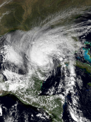
Hurricane Chantal was one of three tropical cyclones to make landfall in Texas during the 1989 Atlantic hurricane season. The third named storm and the first hurricane of the season, Chantal slowly developed on July 30 in the southern Gulf of Mexico from a tropical disturbance that was previously within Intertropical Convergence Zone (ITCZ) while near Trinidad and Tobago. While heading north-northwestward, the depression steadily intensified and was upgraded to Tropical Storm Chantal on the following day. Thereafter, Chantal quickly strengthen and became a hurricane on August 1. After intensifying slightly further, Chantal made landfall near High Island, Texas later that day. The storm quickly weakened upon moving inland and fell to tropical storm intensity a few hours after landfall. Early on August 2, Chantal weakened to a tropical depression and dissipated over Oklahoma by August 4.

<span class="mw-page-title-main">Hurricane Abby (1968)</span> Category 1 Atlantic hurricane in 1968

Hurricane Abby made landfall in Cuba, Florida, and North Carolina in June 1968. The first tropical cyclone, first named storm, and first hurricane on the season, Abby developed over the northwestern Caribbean Sea on June 1, as a result of the interaction between a mid-tropospheric trough and a cold front. Moving generally north-northeastward, the depression slowly strengthened while approaching the western tip of Cuba, becoming Tropical Storm Abby late on June 2. Shortly thereafter, Abby made landfall in Pinar del Río Province. The storm dropped heavy rainfall in western Cuba, with up to 12 inches (300 mm) on Isla de la Juventud. However, no flooding was reported. After reaching the southeastern Gulf of Mexico on June 3, Abby strengthened further and became a Category 1 hurricane on the modern-day Saffir–Simpson hurricane wind scale. However, early on June 4, Abby weakened to a tropical storm. Around midday on June 4, the system made landfall near Punta Gorda, Florida as a strong tropical storm.

<span class="mw-page-title-main">Tropical Storm Chris (1982)</span> Atlantic tropical storm in 1982

Tropical Storm Chris caused minor flooding along the Gulf Coast of the United States in September 1982. The fifth tropical or subtropical cyclone and third named storm of the 1982 Atlantic hurricane season, Chris developed from a surface low-pressure area in the northern Gulf of Mexico on September 9. Although initially displaying subtropical characteristics, the low pressure area gradually acquired tropical characteristics, and was reclassified as Tropical Depression Four within 24 hours of development. The depression then began to intensify and was upgraded to Tropical Storm Chris on September 10. Thereafter, the storm turned north-north-eastward and strengthened further. On September 11, Chris peaked as a 65 mph (100 km/h) tropical storm. Later that day, it made landfall near Sabine Pass, Port Arthur, Texas. By September 13, Chris dissipated over Arkansas.

<span class="mw-page-title-main">Hurricane Humberto (2007)</span> Category 1 Atlantic hurricane in 2007

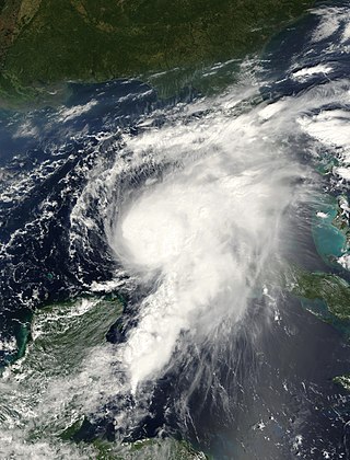
Hurricane Humberto was a Category 1 hurricane that formed and intensified faster than any other North Atlantic tropical cyclone on record, before landfall. The eighth named storm and third hurricane of the 2007 Atlantic hurricane season, Humberto developed on September 12, 2007, in the northwestern Gulf of Mexico,. The tropical cyclone rapidly strengthened and struck High Island, Texas, with winds of about 90 mph (140 km/h) early on September 13. It steadily weakened after moving ashore, and on September 14, Humberto began dissipating over northwestern Georgia as it interacted with an approaching cold front.

<span class="mw-page-title-main">Hurricane Able (1952)</span> Category 2 Atlantic hurricane in 1952

Hurricane Able was the only hurricane to make landfall in the United States in the 1952 season. Forming on August 18 off the west coast of Africa, Able moved generally west- to west-northwestward for much of its duration. It was first observed by the Hurricane Hunters on August 25 to the north of the Lesser Antilles. Two days later, Able attained hurricane status, and on August 30 it turned sharply to the north-northwest in response to a cold front. The hurricane reached peak winds of 100 mph (160 km/h) just prior to moving ashore near Beaufort, South Carolina on August 31. Although it quickly weakened below hurricane force, Able maintained tropical storm force for almost two days over land, eventually dissipating over Maine on September 2.

References

  1. 1 2 3 4 Miles Lawrence (October 12, 1988). "Tropical Storm Chris Preliminary Report". National Hurricane Center. p. 1. Retrieved March 7, 2012.
  2. "Tropical Depression is Heading Towards Florida". United Press International . 1988.
  3. Staff Writer (August 27, 1988). "Tropical Storm Chris Hits". Lodi News-Sentinel . United Press International. Retrieved March 7, 2012.
  4. 1 2 3 David Roth (May 16, 2007). "Tropical Storm Chris - August 22-30, 1988". Hydrometeorological Prediction Center. Retrieved March 7, 2012.
  5. Staff Writer (August 26, 1988). "Rain, Wind Kill 3 As Storm Passes Puerto Rico". The Post and Courier . Associated Press. Retrieved March 7, 2012.
  6. 1 2 Staff Writer (August 27, 1988). "Depression may pick up steam as it nears Florida". Star-News . Retrieved March 7, 2012.
  7. David Longshore (1998). Encyclopedia of hurricanes, typhoons and cyclones . Facts on File. pp.  168. ISBN   0-8160-3398-6.
  8. 1 2 Miles Lawrence (October 12, 1988). "Tropical Storm Chris Preliminary Report". National Hurricane Center. p. 4. Retrieved March 7, 2012.
  9. "Tropical Cyclone Rainfall for the Southeast". Weather Prediction Center. 2012. Retrieved July 4, 2012.
  10. Miles Lawrence and James Gross (October 1989). "Atlantic Hurricane Season of 1988" (PDF). National Hurricane Center. Retrieved March 7, 2012.
  11. Staff Writer (August 29, 1988). "Tropical Storm Chris heading for Virginia". The Gadsden Times . Associated Press. Retrieved March 7, 2012.
  12. 1 2 3 4 5 6 7 "Storm Data — August 1988" (PDF). National Oceanic and Atmospheric Administration. National Climatic Data Center . Retrieved May 26, 2012.
  13. Staff Writer (August 29, 1988). "Storm Destroys Mobile Homes, Kills 1". The Daily News . Associated Press. Retrieved March 7, 2012.
  14. Staff Writer (August 29, 1988). "Storm Strikes South Carolina, Killing One". New York Times. Associated Press. Retrieved March 7, 2012.
  15. 1 2 3 Staff and Wire Reports (August 29, 1988). "Tropical Storm Chris Brings Damage, Rain To Tar Heel State". The Mount Airy News . Retrieved March 7, 2012.
  16. Allen Bruce (August 30, 1988). "Storm, Cold Front Spark Flood Warnings In N.E." The Daily Gazette . United Press International. Retrieved March 8, 2012.
  17. 1 2 Michael Molinski (August 30, 1988). "Storm Chris leaves damage in its wake". The Bryan Times . Retrieved March 8, 2012.
  18. Staff Writer (August 30, 1988). "Remnants of Chris Over Maine". The Albany Herald . Associated Press. Retrieved March 8, 2012.
  19. Canadian Hurricane Centre (2006) CHC Report on Chris Archived 2007-08-04 at the Wayback Machine URL Accessed: August 16, 2006
Tropical Storm Chris
Chris 1988-08-28 1331Z.png
Tropical Storm Chris at peak intensity near landfall in Georgia on August 28