Tybee Island is a city and a barrier island located in Chatham County, Georgia, 18 miles (29 km) east of Savannah, United States. Though the name "Tybee Island" is used for both the island and the city, geographically they are not identical: only part of the island's territory lies within the city.
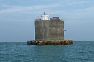
The Nab Tower was a tower planned for anti-submarine protection in the Solent in World War I. It was sunk over the Nab rocks east of the Isle of Wight to replace a lightship after the war, and is a well-known landmark for sailors as it marks the deep-water eastern entry into the Solent.

Boon Island is a barren rocky island in the Gulf of Maine 6 mi (9.7 km) off the coast of York, Maine. The island, which is approximately 300 ft (91 m) by 700 ft (210 m) at low tide, is the site of Boon Island Light, at 137 ft (42 m) high, it is the tallest lighthouse in New England. Numerous vessels have been wrecked on its rocky shoreline. John Winthrop, the English Puritan lawyer and one of the leading figures in founding the Massachusetts Bay Colony mentions passing Boon Island in the 1600s.
Crisp Point was one of five U.S. Life-Saving Service Stations along the coast of Lake Superior between Munising and Whitefish Point in the Upper Peninsula of Michigan. The lighthouse is within McMillan Township in Luce County.
Ambrose Light, often called Ambrose Tower, was the light station at the convergence of several major shipping lanes in Lower New York Bay, including Ambrose Channel, the primary passage for ships entering and departing the Port of New York and New Jersey.

Sand Key Light is a lighthouse 6 nautical miles southwest of Key West, Florida, between Sand Key Channel and Rock Key Channel, two of the channels into Key West, on a reef intermittently covered by sand. At times the key has been substantial enough to have trees, and in 1900 nine to twelve thousand terns nested on the island. At other times the island has been washed away completely.

The St. Johns River Light is a decommissioned lighthouse in Jacksonville, Florida, U.S., which stands near the mouth of the St. Johns River. It is located on the grounds of Naval Station Mayport in the Mayport area. Constructed in 1858, it was decommissioned in 1929 and replaced with a lightship. It is sometimes known as the "Old St. Johns River Light" to distinguish it from the modern St. Johns Light, built in 1954.

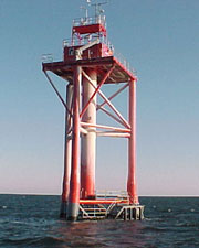
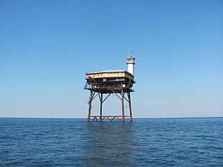
A Texas Tower lighthouse is a structure which is similar to an off-shore oil platform. Seven of these structures were built in the 1960s off the shores of the United States. Automation started in the late 1970s, which led to the obsolescence of the housing built for the keepers which resulted in such a large structure. Three of the towers were dismantled over time due to deteriorating structural conditions among other problems, while another one was destroyed in a ship collision. The last Texas Tower was deactivated in 2016 having served for over half a century. Today only three of the former lights remain.
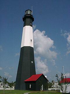
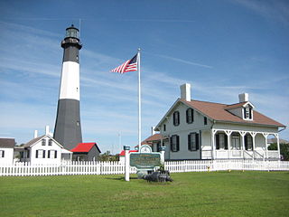
Tybee Island Light is a lighthouse next to the Savannah River Entrance, on the northeast end of Tybee Island, Georgia. It is one of seven surviving colonial era lighthouse towers, though highly modified in the mid 1800s.

The passenger steamer City of Columbus ran aground on Devil’s Bridge off the Gay Head Cliffs in Aquinnah, Massachusetts, in the early hours of January 18, 1884. She was owned by Boston & Savannah Steamship Company and was built in 1878 by Delaware River Iron Ship Building and Engine Works, at Chester, Pennsylvania. City of Columbus made regular runs from Boston, Massachusetts to Savannah, Georgia.

St. Clair Flats Front and Rear Range Light are two lighthouse structures situated off the southeastern tip of Harsens Island at Lake St. Clair.

The Elbow of Cross Ledge Light was a lighthouse on the north side of the ship channel in Delaware Bay in Cumberland County, New Jersey, on the east coast of the United States, west of Egg Island Point. It was destroyed by a ship collision in 1953 and replaced by a skeleton tower on the same foundation.
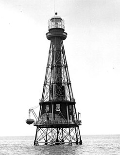
Diamond Shoal Light is an inactive offshore lighthouse marking Diamond Shoals off Cape Hatteras.
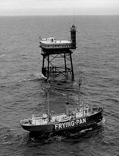
Frying Pan Shoals Light Tower is a decommissioned lighthouse located on the Frying Pan Shoals approximately 39 miles (63 km) southeast of Southport, North Carolina, and 32 miles (51 km) from Bald Head Island, North Carolina. The tower is currently privately owned and was formerly a bed and breakfast retreat, and is noted for its survival through several significant tropical storms.
Buzzards Bay Entrance Light is a lighthouse located in open water at the entrance to Buzzards Bay, about four nautical miles west southwest of Cuttyhunk Island, Massachusetts.

The Old Harbor Light, which is also known as the Savannah Harbor Rear Range Light or the Beacon Range Light, is a former aid to navigation in Emmet Park on East Bay Street in Savannah, Georgia. The light has the appearance of a giant street light. It is within the boundaries of Savannah Historic District and was erected by the federal government in 1858, contemporary with most of the structures in the district.
SS Iowa was a steamship built by the Western Pipe and Steel Company of San Francisco, California in 1920 for the U.S. government and was known as the SS West Cadron. It served in the Quaker Line subsidiary of the States Steamship Company. from 1928—when it was renamed the Iowa—until January 12, 1936, when it ran aground on Peacock Spit, Washington, part of the Columbia Bar at the mouth of the Columbia River.
The Ship Shoal Light is a screw-pile lighthouse located in the Gulf of Mexico southwest of the Isles Dernieres off the coast of Louisiana. It is currently abandoned.

The Ile Parisienne Light was built in 1911 on the southern tip of remote Ile Parisienne in the middle of Whitefish Bay on Lake Superior on a major shipping lane for ingress/egress to the Soo Locks. It is now a well-known landmark to shipping traffic and pleasure craft. The light is automated and remains seasonally active.

