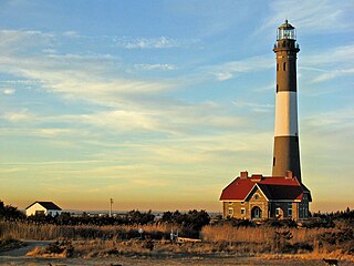
The Fire Island Lighthouse is a visible landmark on the Great South Bay, in southern Suffolk County, New York on the western end of Fire Island, a barrier island off the southern coast of Long Island. The lighthouse is located within Fire Island National Seashore and just to the east of Robert Moses State Park. It is part of the Fire Island Light Station which contains the light, keepers quarters, the lens building containing the original first-order Fresnel lens, and a boat house.
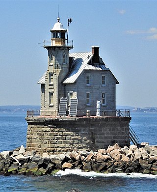
Race Rock Light is a lighthouse on Race Rock Reef, a dangerous set of rocks on Long Island Sound southwest of Fishers Island, New York and the site of many shipwrecks. It is currently owned and maintained by the New London Maritime Society as part of the National Historic Lighthouse Preservation Act program.
Halfway Rock Lighthouse is a lighthouse located on a barren ledge in Casco Bay, Maine. The lighthouse tower, which has a height of 76 feet (23 m), and the attached ex-boathouse are all that remains, as the other buildings have been taken away in storms. The name "Halfway Rock" comes from the position of the rock which is halfway between Cape Elizabeth and Cape Small, the southwest and northeast extremities of Casco Bay, which are about 18 nautical miles (33 km) apart.

The Charlevoix South Pier Light Station is located on Lake Michigan at the entrance to Lake Charlevoix in Charlevoix County in the U.S. state of Michigan at the end of the south pier/breakwater of the channel leading to Round Lake in the city of Charlevoix.

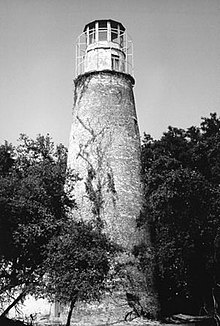
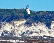
The Amelia Island Light is the oldest existing lighthouse in the state of Florida in the United States. It is located near the northern end of Amelia Island in the northeastern part of the state. Its light marks St. Marys Entrance, the inlet leading to St. Marys River, the Cumberland Sound and the harbor of Fernandina Beach, Florida along the Amelia River. The white light flashes every ten seconds which turns red from 344° to 360° when covering the shoal water in the vicinity of Nassau Sound.

Because it was positioned near the busy shipping lanes of the mid-19th century, a lighthouse was built on Granite Island in 1868 by the U.S. Lighthouse Board and commissioned in 1869.

The Ponce de Leon Inlet Light is a lighthouse and museum located at Ponce de León Inlet in Central Florida. At 175 feet (53 m) in height, it is the tallest lighthouse in the state and one of the tallest in the United States. It is located between St. Augustine Light and Cape Canaveral Light. Restored by the Ponce de Leon Inlet Lighthouse Preservation Association, the lighthouse became a National Historic Landmark in 1998.

Boon Island Light is located on the 300-by-700-foot Boon Island off the southern coast of Maine, United States, near Cape Neddick. Boon Island Light has the distinction of being the tallest lighthouse in both Maine and New England at 133 feet (41 m). The lighthouse has a focal plane at 137 feet (42 m) above mean high water. The light's beacon flashes white every 5 seconds.
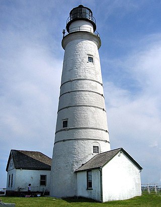
Boston Light is a lighthouse located on Little Brewster Island in outer Boston Harbor, Massachusetts. The first lighthouse to be built on the site dates back to 1716, and was the first lighthouse to be built in what is now the United States. The current lighthouse dates from 1783, is the second oldest working lighthouse in the United States, and is the only lighthouse to still be actively staffed by the United States Coast Guard, being automated in 1998 though there is still a keeper acting as tour guide. The structure was designated a National Historic Landmark in 1964.

Horton Point Light is a lighthouse on the north side of Eastern Long Island, New York in the hamlet of Southold. The lighthouse and the grounds surrounding it are under the supervision of the Town of Southold Park District.

Sand Hills was an active lighthouse on the shore of Lake Superior is on private property and is currently closed to the public. It is located in Ahmeek in Keweenaw County in the Keweenaw Peninsula, which is the northern part of the Upper Peninsula in Michigan. It was listed in the National Register of Historic Places in 1994.

The Cape Romain Lighthouses are a pair of brick lighthouses on Lighthouse Island southeast of McClellanville, South Carolina. The lighthouses are on the Cape Romain National Wildlife Refuge. The lighthouses were named to the National Register of Historic Places in 1981.

The Marquette Harbor Light is located on Lake Superior in Marquette, Michigan, a part of the Upper Peninsula. It is an active aid to navigation.
The Rock of Ages Light is a U.S. Coast Guard lighthouse on a small rock outcropping approximately 2.25 miles (3.62 km) west of Washington Island and 3.5 miles (5.6 km) west of Isle Royale, in Eagle Harbor Township, Keweenaw County, Michigan. It is an active aid to navigation.

The Tarpaulin Cove Light is a historic lighthouse on Naushon Island, one of the Elizabeth Islands of southern Massachusetts. It is located in the town of Gosnold, Massachusetts. Built on the site of a light station first established privately in the 18th century, the current tower dates from 1891. A keeper's house built at the same time has not survived. The light is 78 feet (24 m) above Mean High Water, and its white light is visible for 9 nautical miles.
Galloo Island light is a historic lighthouse that is located the South Western side of the island of Galloo. It is found six miles off the mainland of Jefferson Country which is part of the state of New York. According to its location, it falls under the jurisdiction of the town of Hounsfield. The light tower and the majority of the island are privately owned. However, because of the law, the Coast Guard is permitted to cross into this private property because of the light in the tower that is used to guide ships. The lighthouse is a fixed white light that produces a beam that is visible at a maximum distance of 15 miles. It also consists of a steam whistle that it sounds when the weather turns foggy. The whistle blows for 10 seconds and then it is silent for 30 seconds. The island does not have a harbor and landings have to be made from smaller boats. Today it stands tall and abandoned, overlooking the waves.
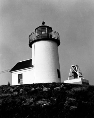
Curtis Island Light, originally Negro Island Light, is a lighthouse marking the approach to the harbor of Camden, Maine. It is located on Curtis Island, which shelters the harbor from ocean storms. It was first established in 1835, and the present structure was built in 1896. The light was automated in 1972, and listed on the National Register of Historic Places in 1973.
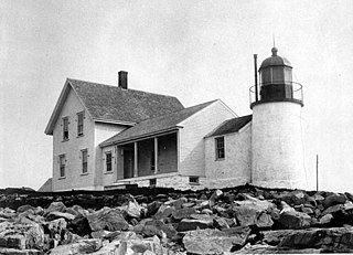
Winter Harbor Light is a lighthouse in Winter Harbor, Maine. It is located on Mark Island, a small island between the Schoodic Peninsula and Turtle Island, near the entry to the town's main harbor. The light was built in 1856 and was deactivated in 1933; it is no longer an aid to navigation, and is privately owned. The light was listed on the National Register of Historic Places as Winter Harbor Light Station on February 1, 1988.
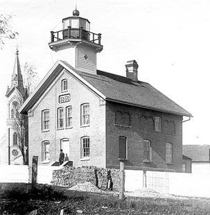
The Port Washington Light is a historical lighthouse in Port Washington, Wisconsin. Replaced by the Port Washington Breakwater Light and converted to a normal dwelling, it was restored with the assistance of the Grand Duchy of Luxembourg and currently serves as a museum.