The 2000 Atlantic hurricane season was a fairly active hurricane season, but featured the latest first named storm in a hurricane season since 1992. The hurricane season officially began on June 1, and ended on November 30. It was slightly above average due to a La Niña weather pattern although most of the storms were weak. It was also the only Season to Include 2 storms in Ireland. The first cyclone, Tropical Depression One, developed in the southern Gulf of Mexico on June 7 and dissipated after an uneventful duration. However, it would be almost two months before the first named storm, Alberto, formed near Cape Verde; Alberto also dissipated with no effects on land. Several other tropical cyclones—Tropical Depression Two, Tropical Depression Four, Chris, Ernesto, Nadine, and an unnamed subtropical storm—did not impact land. Five additional storms—Tropical Depression Nine, Florence, Isaac, Joyce, and Leslie—minimally affected land areas.

The 1961 Atlantic hurricane season was a hyperactive Atlantic hurricane season, with an accumulated cyclone energy (ACE) total of 189. The season, however, was an average one in terms of named storms. The season featured eight hurricanes and a well above average number of five major hurricanes. It was previously thought that the season had a record-tying seven major hurricanes, before the Atlantic hurricane reanalysis project downgraded two storms in 2019. Two Category 5 hurricanes were seen in 1961, making it one of only seven Atlantic hurricane seasons to feature multiple Category 5 hurricanes in one season. The season started on June 15, and ended on November 15. These dates conventionally delimit the period of each year when most tropical cyclones form in the Atlantic basin. The first system, an operationally unclassified tropical depression, formed offshore east Central Florida on June 10, but dissipated a few days later. Next, Hurricane Anna developed in the eastern Caribbean Sea near the Windward Islands on July 20. It brought minor damage to the islands, as well as wind and flood impacts to Central America after striking Belize as a hurricane. Anna caused one death and about $300,000 (1961 USD) in damage. Activity went dormant for nearly a month and a half, until Hurricane Betsy developed on September 2. Betsy peaked as a Category 4 hurricane, but remained at sea and caused no impact.

The 1966 Atlantic hurricane season saw the Weather Bureau office in Miami, Florida, be designated as the National Hurricane Center (NHC) and assume responsibility of tropical cyclone forecasting in the basin. The season officially began on June 1, and lasted until November 30. These dates conventionally delimit the period of each year when most tropical cyclones form in the Atlantic basin. It was an above-average season in terms of tropical storms, with a total of 15. The first system, Hurricane Alma, developed over eastern Nicaragua on June 4 and became the most recent major hurricane in the month of June. Alma brought severe flooding to Honduras and later to Cuba, but caused relatively minor impact in the Southeastern United States. Alma resulted in 91 deaths and about $210.1 million (1966 USD) in damage.

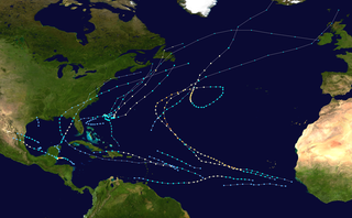
The 1988 Atlantic hurricane season was a near average season that proved costly and deadly, with 15 tropical cyclones directly affecting land. The season officially began on June 1, 1988, and lasted until November 30, 1988, although activity began on May 30 when a tropical depression developed in the Caribbean. The June through November dates conventionally delimit the period of each year when most tropical cyclones form in the Atlantic basin. The first cyclone to attain tropical storm status was Alberto on August 8, nearly a month later than usual. The final storm of the year, Tropical Storm Keith, became extratropical on November 24. The season produced 19 tropical depressions of which 12 attained tropical storm status. One tropical storm was operationally classified as a tropical depression but was reclassified in post-analysis. Five tropical cyclones reached hurricane status of which three became major hurricanes reaching Category 3 on the Saffir–Simpson scale.

The 1950 Atlantic hurricane season was the first year in the Atlantic hurricane database (HURDAT) that storms were given names in the Atlantic basin. Names were taken from the Joint Army/Navy Phonetic Alphabet, with the first named storm being designated "Able", the second "Baker", and so on. It was a very active season with sixteen tropical storms, with eleven of them developing into hurricanes. Six of these hurricanes were intense enough to be classified as major hurricanes—a denomination reserved for storms that attained sustained winds equivalent to a Category 3 or greater on the present-day Saffir–Simpson scale. One storm, the twelfth of the season, was unnamed and was originally excluded from the yearly summary, and three additional storms were discovered in re-analysis. The large quantity of strong storms during the year yielded, prior to modern reanalysis, what was the highest seasonal accumulated cyclone energy (ACE) of the 20th century in the Atlantic basin; 1950 held the seasonal ACE record until broken by the 1995 Atlantic hurricane season. However, later examination by researchers determined that several storms in the 1950 season were weaker than thought, leading to a lower ACE than assessed originally. This season also set the record for the most tropical storms, eight, in the month of October.

The 1951 Atlantic hurricane season was the first hurricane season in which tropical cyclones were officially named by the United States Weather Bureau. The season officially started on June 15, when the United States Weather Bureau began its daily monitoring for tropical cyclone activity; the season officially ended on November 15. It was the first year since 1937 in which no hurricanes made landfall on the United States; as Hurricane How was the only tropical storm to hit the nation, the season had the least tropical cyclone damage in the United States since the 1939 season. As in the 1950 season, names from the Joint Army/Navy Phonetic Alphabet were used to name storms this season.

The 1953 Atlantic hurricane season was the first time an organized list of female names was used to name Atlantic storms. It officially began on June 15, and lasted until November 15, although activity occurred both before and after the season's limits. The season was active with fourteen total storms, six of which developed into hurricanes; four of the hurricanes attained major hurricane status, or a Category 3 or greater on the Saffir-Simpson scale.

The 1945 Atlantic hurricane season produced multiple landfalling tropical cyclones. It officially began on June 16 and lasted until October 31, dates delimiting the period when a majority of storms were perceived to form in the Atlantic Ocean. A total of 11 systems were documented, including a late-season cyclone retroactively added a decade later. Five of the eleven systems intensified into hurricanes, and two further attained their peaks as major hurricanes. Activity began with the formation of a tropical storm in the Caribbean on June 20, which then made landfalls in Florida and North Carolina at hurricane intensity, causing one death and at least $75,000 in damage. In late August, a Category 3 hurricane on the modern-day Saffir–Simpson hurricane wind scale struck the Texas coastline, with 3 deaths and $20.1 million in damage. The most powerful hurricane of the season, reaching Category 4 intensity, wrought severe damage throughout the Bahamas and East Coast of the United States, namely Florida, in mid-September; 26 people were killed and damage reached $60 million. A hurricane moved ashore the coastline of Belize in early October, causing one death, while the final cyclone of the year resulted in 5 deaths and $2 million in damage across Cuba and the Bahamas two weeks later. Overall, 36 people were killed and damage reached at least $82.85 million.

The 1942 Atlantic hurricane season was one of seven seasons to feature multiple hurricane landfalls in Texas. The season officially lasted from June 16, 1942, to October 31, 1942. These dates conventionally delimit the period of each year when most tropical cyclones form in the Atlantic basin. A total of 11 tropical storms from 1943 are listed in the Atlantic hurricane database, with two additional tropical depressions. The first system of the year, a tropical depression, developed over the central Gulf of Mexico on June 3, while the last system, the Belize hurricane, dissipated over the Yucatán Peninsula on November 11. After the depression dissipated on June 3, the season remained dormant until the next system developed two months later. In mid-August, a hurricane struck Texas, causing about $790,000 (1942 USD) in damage.

The 1936 Atlantic hurricane season was a fairly active season, with 20 tropical cyclones recorded, 17 of which became tropical storms. Seven storms became hurricanes, of which one became a major hurricane. In addition, the season was unusual in the fact that no storms moved across large portions of the Caribbean Sea. Seven storms, including three hurricanes, struck the United States.

The 1921 Atlantic hurricane season was an active hurricane season, with 12 tropical cyclones forming. Among them, seven became tropical storms, of which five strengthened into hurricanes. Furthermore, two of these strengthened into a major hurricane, Category 3 or higher on the modern-day Saffir–Simpson hurricane wind scale, the most since the 1917 season. The first system, a tropical depression, developed on June 1, while the last, a tropical storm, dissipated on November 25. Of note, three tropical cyclones co-existed with another during the season.

The 1915 Atlantic hurricane season featured the strongest tropical cyclone to make landfall in the United States since the 1900 Galveston hurricane. The first storm, which remained a tropical depression, appeared on April 29 near the Bahamas, while the final system, also a tropical depression, was absorbed by an extratropical cyclone well south of Newfoundland on October 22. Of the six tropical storms, five intensified into a hurricane, of which three further strengthened into a major hurricane. Four of the hurricanes made landfall in the United States. The early 20th century lacked modern forecasting and documentation, and thus, the hurricane database from these years may be incomplete.

The 1901 Atlantic hurricane season was the most active season without a major hurricane – tropical cyclones that reach at least Category 3 on the Saffir–Simpson hurricane wind scale – until 2013. The first system was initially observed in the northeastern Caribbean on June 11. The fourteenth and final system transitioned into an extratropical cyclone near Bermuda on November 5. These dates fall within the period with the most tropical cyclone activity in the Atlantic. Eight of the fourteen tropical cyclones existed simultaneously.

Tropical Depression Fourteen was the last tropical depression of the 1987 Atlantic hurricane season and was the third most destructive storm of the year. The depression formed on October 31, 1987, in the Caribbean Sea, heading along a northward path into the southern Gulf of Mexico and into Florida until the system was absorbed on November 4. The path and damage from the depression followed a similar path to Hurricane Floyd earlier in October. The depression peaked in intensity with wind speeds of 35 mph (56 km/h) on November 1 with a minimal barometric pressure reading of 1,004 millibars (29.6 inHg). However, certain barometric readings have considered that the depression may have become a tropical storm.

Tropical Storm Alberto was the first tropical storm of the 2006 Atlantic hurricane season. Forming on June 10 in the northwestern Caribbean, the storm moved generally to the north, reaching a maximum intensity of 70 mph (110 km/h) before weakening and moving ashore in the Big Bend area of Florida on June 13. Alberto then moved through eastern Georgia, North Carolina, and Virginia as a tropical depression before becoming extratropical on June 14.

Hurricane Karen was a hurricane of non-tropical origin that formed in October of the 2001 Atlantic hurricane season. It developed out of the interaction between a cold front and an upper level trough on October 10 located to the south of Bermuda, and quickly strengthened as an extratropical storm. The storm passed near Bermuda on October 12, producing hurricane-force winds on the island. It then organized, becoming a subtropical cyclone on October 12 and a tropical cyclone on October 13. Karen strengthened to reach 80 mph (130 km/h) winds as a Category 1 hurricane on the Saffir-Simpson Hurricane Scale, and after weakening over cooler waters, it made landfall on Nova Scotia as a tropical storm. It quickly became extratropical.

The 1924 Atlantic hurricane season featured the first officially recorded Category 5 hurricane, a tropical cyclone with maximum sustained winds exceeding 155 mph (249 km/h) on the modern-day Saffir–Simpson scale. The first system, Tropical Storm One, was first detected in the northwestern Caribbean Sea on June 18. The final system, an unnumbered tropical depression, dissipated on November 24. These dates fall within the period with the most tropical cyclone activity in the Atlantic. Of the 13 tropical cyclones of the season, six existed simultaneously. The season was average with 11 tropical storms, five of which strengthened into hurricanes. Further, two of those five intensified into major hurricanes, which are Category 3 or higher on the Saffir–Simpson scale.

Hurricane Florence was a strong Atlantic hurricane that struck the Florida Panhandle in September of the 1953 season. The eighth storm and fifth hurricane of the season, Florence developed in the western Caribbean from a tropical wave near Jamaica on September 23. It produced heavy rainfall on the nearby island, and later caused damage in western Cuba. The storm quickly intensified into a hurricane over the Yucatán Channel, and as it moved north through the Gulf of Mexico, Florence's maximum sustained winds reached 125 mph (201 km/h). On September 26, the hurricane hit in a sparsely populated region of western Florida, and shortly after landfall became an extratropical cyclone.
The 1924 Cuba hurricane is the first officially recorded Category 5 Atlantic hurricane on the Saffir–Simpson scale (SSHWS), as well as the first Atlantic hurricane with sustained wind speeds of at least 135, 140, and 145 knots. It is also one of two hurricanes to make landfall on Cuba at Category 5 intensity, the other being Hurricane Irma in 2017 – both are also tied for the strongest Cuban landfall in terms of maximum sustained winds. The hurricane formed on October 14 in the western Caribbean, slowly organizing as it tracked northwestward. By October 16, the storm attained hurricane status to the east of the Yucatán Peninsula, and subsequently executed a small counterclockwise loop. On Friday, October 18, the hurricane intensified rapidly and, on the next day, reached an estimated peak intensity of 165 mph (266 km/h). Shortly thereafter, it struck extreme western Cuba at peak intensity, becoming the strongest hurricane on record to hit the country. Later the hurricane weakened greatly, striking southwestern Florida with winds of 90 mph (140 km/h) in a sparsely populated region. While crossing the state it weakened to tropical storm status, and after accelerating east-northeastward, it was absorbed by a cold front on October 23, to the south of Bermuda.

The 2020 Atlantic hurricane season was the most active Atlantic hurricane season on record, in terms of number of systems. It featured a total of 31 tropical or subtropical cyclones, with all but one cyclone becoming a named storm. Of the 30 named storms, 14 developed into hurricanes, and a record-tying seven further intensified into major hurricanes. It was the second and final season to use the Greek letter storm naming system, the first being 2005, the previous record. Of the 30 named storms, 11 of them made landfall in the contiguous United States, breaking the record of nine set in 1916. During the season, 27 tropical storms established a new record for earliest formation date by storm number. This season also featured a record ten tropical cyclones that underwent rapid intensification, tying it with 1995, as well as tying the record for most Category 4 hurricanes in a singular season in the Atlantic Basin. This unprecedented activity was fueled by a La Niña that developed in the summer months of 2020, continuing a stretch of above-average seasonal activity that began in 2016. Despite the record-high activity, this was the first season since 2015 in which no Category 5 hurricane formed.


