Pettus, Texas | |
---|---|
Coordinates: 28°37′5″N97°48′8″W / 28.61806°N 97.80222°W | |
Country | United States |
State | Texas |
County | Bee |
Area | |
• Total | 5.8 sq mi (15.1 km2) |
• Land | 5.8 sq mi (15.1 km2) |
• Water | 0.0 sq mi (0.0 km2) |
Elevation | 299 ft (91 m) |
Population (2020) | |
• Total | 449 |
• Density | 77/sq mi (30/km2) |
Time zone | UTC-6 (Central (CST)) |
• Summer (DST) | UTC-5 (CDT) |
ZIP code | 78146 |
Area code | 361 |
FIPS code | 48-57116 [1] |
GNIS feature ID | 1365119 [2] |
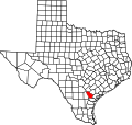
Pettus is a census-designated place (CDP) in Bee County, Texas, United States. The population was 449 at the 2020 census.
Pettus is located in northern Bee County at 28°37′5″N97°48′8″W / 28.61806°N 97.80222°W (28.6180446, -97.8022219). [2] U.S. Route 181 passes through the community, leading southward 16 miles (26 km) to Beeville, the county seat, and northward 14 miles (23 km) to Kenedy.
According to the United States Census Bureau, the CDP has a total area of 5.8 square miles (15.1 km2), all land. [3]
Census | Pop. | Note | %± |
---|---|---|---|
2000 | 608 | — | |
2010 | 558 | −8.2% | |
2020 | 449 | −19.5% | |
U.S. Decennial Census [4] 1850–1900 [5] 1910 [6] 1920 [7] 1930 [8] 1940 [9] 1950 [10] 1960 [11] 1970 [12] 1980 [13] 1990 [14] 2000 [15] 2010 [16] 2020 [17] |
Pettus was first listed as a census designated place in the 2000 U.S. Census. [15]
As of the census [1] of 2000, there were 608 people, 223 households, and 169 families residing in the CDP. The population density was 104.8 inhabitants per square mile (40.5/km2). There were 257 housing units at an average density of 44.3 per square mile (17.1/km2). The racial makeup of the CDP was 71.88% White, 0.49% Native American, 24.67% from other races, and 2.96% from two or more races. Hispanic or Latino of any race were 54.11% of the population.
There were 223 households, out of which 35.9% had children under the age of 18 living with them, 56.5% were married couples living together, 14.8% had a female householder with no husband present, and 24.2% were non-families. 22.0% of all households were made up of individuals, and 10.8% had someone living alone who was 65 years of age or older. The average household size was 2.73 and the average family size was 3.17.
In the CDP, the population was spread out, with 29.3% under the age of 18, 7.4% from 18 to 24, 22.0% from 25 to 44, 26.8% from 45 to 64, and 14.5% who were 65 years of age or older. The median age was 37 years. For every 100 females, there were 99.3 males. For every 100 females age 18 and over, there were 90.3 males.
The median income for a household in the CDP was $28,500, and the median income for a family was $35,469. Males had a median income of $23,750 versus $19,464 for females. The per capita income for the CDP was $12,486. About 11.8% of families and 16.0% of the population were below the poverty line, including 21.2% of those under age 18 and 8.2% of those age 65 or over.
Pettus is served by the Pettus Independent School District and home to the Pettus Secondary School Eagles.
Normanna is a census-designated place in Bee County, Texas, United States. The population was 98 at the 2020 census.
Tuleta is a census-designated place (CDP) in Bee County, Texas, United States. The population was 231 at the 2020 census.
Tulsita is a census-designated place (CDP) in Bee County, Texas, United States. The population was 31 at the 2020 census.
Bixby is a census-designated place (CDP) in Cameron County, Texas, United States. The population was 352 at the 2020 census. It is part of the Brownsville–Harlingen Metropolitan Statistical Area.
Cameron Park is a census-designated place (CDP) in Cameron County, Texas, United States. The population was 6,099 at the 2020 census. It is part of the Brownsville–Harlingen Metropolitan Statistical Area.
Encantada-Ranchito-El Calaboz, also known as El Calaboz Rancheria in the San Pedro de Carricitos Land Grant, is a census-designated place (CDP) in Cameron County, Texas, United States. The population was 1,981 at the 2020 census. It is part of the Brownsville–Harlingen Metropolitan Statistical Area.
Green Valley Farms is a census-designated place (CDP) in Cameron County, Texas, United States. The population was 655 at the 2020 census, down from 1,272 at the 2010 census. It is part of the Brownsville–Harlingen Metropolitan Statistical Area.
La Feria North is a census-designated place (CDP) in Cameron County, Texas, United States. The population was 225 at the 2020 census. It is part of the Brownsville–Harlingen Metropolitan Statistical Area.
Lasana is a census-designated place (CDP) in Cameron County, Texas, United States. The population was 84 at the 2010 census, down from 135 at the 2000 census. It is part of the Brownsville–Harlingen Metropolitan Statistical Area.
Laureles is a census-designated place (CDP) in Cameron County, Texas, United States. The population was 4,111 at the 2020 census. It is part of the Brownsville–Harlingen Metropolitan Statistical Area. Laureles is an area between Los Fresnos and San Benito.
Lozano is a census-designated place (CDP) in Cameron County, Texas, United States. The population was 404 at the 2010 census, up from 324 at the 2000 census. By the 2020 census, the population went drastically down to 174. It is part of the Brownsville–Harlingen Metropolitan Statistical Area.
Olmito is a census-designated place (CDP) in Cameron County, Texas, United States. Olmito is Spanish for "little elm". The population was 1,021 at the 2020 census. It is part of the Brownsville–Harlingen Metropolitan Statistical Area. Olmito is the self-described "mesquite capital of the world."
Ratamosa is a census-designated place (CDP) in Cameron County, Texas, United States. The population was 197 at the 2020 census. It is part of the Brownsville–Harlingen Metropolitan Statistical Area.
Solis is a census-designated place (CDP) in Cameron County, Texas, United States. The population was 722 at the 2020 census. It is part of the Brownsville–Harlingen Metropolitan Statistical Area.
Villa del Sol is a census-designated place (CDP) in Cameron County, Texas, United States. The population was 153 at the 2020 census. It is part of the Brownsville–Harlingen Metropolitan Statistical Area.
Yznaga is a census-designated place (CDP) in Cameron County, Texas, United States. The population was 108 at the 2020 census. It is part of the Brownsville–Harlingen Metropolitan Statistical Area.
Redwood is an unincorporated community and census-designated place (CDP) in Guadalupe County, Texas, United States. The population was 4,003 at the 2020 census, a decline from the figure of 4,338 tabulated in 2010. It is part of the San Antonio Metropolitan Statistical Area.
Indian Hills is a census-designated place (CDP) in Hidalgo County, Texas, United States. At the 2020 United States Census, the population was 2,694. It is part of the McAllen–Edinburg–Mission Metropolitan Statistical Area.
Windermere is a former census-designated place (CDP) in Travis County, Texas, United States. The population was 1,037 at the 2010 census. It has since largely been annexed by the city of Pflugerville.
Serenada is a census-designated place (CDP) in Williamson County, Texas, United States. The population was 2,098 at the 2020 census. Those living in Serenada have Georgetown addresses.