Tynan, Texas

Last updated

Tynan, Texas
TXMap-doton-Tynan.PNG
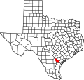
Location of Tynan, Texas
Bee Tynan.svg
Coordinates: 28°10′10″N97°45′29″W / 28.16944°N 97.75806°W / 28.16944; -97.75806
Country United States
State Texas
County Bee
Area
  Total3.5 sq mi (9.0 km2)
  Land3.5 sq mi (9.0 km2)
  Water0.0 sq mi (0.0 km2)
Elevation
167 ft (51 m)
Population
 (2020)
  Total254
  Density73/sq mi (28/km2)
Time zone UTC-6 (Central (CST))
  Summer (DST) UTC-5 (CDT)
ZIP code
78391
Area code 361
FIPS code 48-74168 [1]
GNIS feature ID1349008 [2]

Tynan is a census-designated place (CDP) in Bee County, Texas, United States. The population was 254 at the 2020 census.

Contents

Geography

Tynan is located along the southern border of Bee County at 28°10′10″N97°45′29″W / 28.16944°N 97.75806°W / 28.16944; -97.75806 (28.169448, -97.757946). [3] Texas State Highway 359 passes through the community, which leads northeastward 7 miles (11 km) to Skidmore and southwestward 5 miles (8 km) to Interstate 37 on the outskirts of Mathis.

According to the United States Census Bureau, the Tynan CDP has a total area of 3.5 square miles (9.0 km2), all land. [4]

Demographics

Historical population
CensusPop.Note
2000 301
2010 278−7.6%
2020 254−8.6%
U.S. Decennial Census [5]
1850–1900 [6] 1910 [7]
1920 [8] 1930 [9] 1940 [10]
1950 [11] 1960 [12] 1970 [13]
1980 [14] 1990 [15] 2000 [16]
2010 [17] 2020 [18]

Tynan was first listed as a census designated place in the 2000 U.S. Census. [16]

As of the census [1] of 2000, there were 301 people, 92 households, and 75 families residing in the CDP. The population density was 87.6 inhabitants per square mile (33.8/km2). There were 109 housing units at an average density of 31.7 per square mile (12.2/km2). The racial makeup of the CDP was 79.73% White, 1.33% African American, 1.66% Native American, 16.28% from other races, and 1.00% from two or more races. Hispanic or Latino of any race were 78.74% of the population.

There were 92 households, out of which 42.4% had children under the age of 18 living with them, 62.0% were married couples living together, 16.3% had a female householder with no husband present, and 17.4% were non-families. 15.2% of all households were made up of individuals, and 8.7% had someone living alone who was 65 years of age or older. The average household size was 3.27 and the average family size was 3.64.

In the CDP, the population was spread out, with 32.9% under the age of 18, 8.3% from 18 to 24, 26.2% from 25 to 44, 21.3% from 45 to 64, and 11.3% who were 65 years of age or older. The median age was 33 years. For every 100 females, there were 107.6 males. For every 100 females age 18 and over, there were 96.1 males.

The median income for a household in the CDP was $11,250, and the median income for a family was $11,786. Males had a median income of $15,833 versus $12,000 for females. The per capita income for the CDP was $5,874. About 43.8% of families and 47.4% of the population were below the poverty line, including 63.1% of those under the age of eighteen and 48.7% of those 65 or over.

Education

Tynan and its neighboring community of Skidmore are served by the Skidmore-Tynan Independent School District.

Related Research Articles

<span class="mw-page-title-main">Skidmore, Texas</span> Census-designated place in Texas, United States

Skidmore is a census-designated place (CDP) in Bee County, Texas, United States. The population was 863 at the 2020 census.

<span class="mw-page-title-main">Bixby, Texas</span> CDP in Texas, United States

Bixby is a census-designated place (CDP) in Cameron County, Texas, United States. The population was 352 at the 2020 census. It is part of the Brownsville–Harlingen Metropolitan Statistical Area.

<span class="mw-page-title-main">Cameron Park, Texas</span> CDP in Texas, United States

Cameron Park is a census-designated place (CDP) in Cameron County, Texas, United States. The population was 6,099 at the 2020 census. It is part of the Brownsville–Harlingen Metropolitan Statistical Area.

<span class="mw-page-title-main">El Camino Angosto, Texas</span> Census-designated place in Texas, United States

El Camino Angosto is a census-designated place (CDP) in Cameron County, Texas, United States. The population was 186 at the 2020 census. It is part of the Brownsville–Harlingen Metropolitan Statistical Area.

<span class="mw-page-title-main">Green Valley Farms, Texas</span> Census-designated place in Texas, United States

Green Valley Farms is a census-designated place (CDP) in Cameron County, Texas, United States. The population was 655 at the 2020 census, down from 1,272 at the 2010 census. It is part of the Brownsville–Harlingen Metropolitan Statistical Area.

<span class="mw-page-title-main">La Feria North, Texas</span> Census-designated place in Texas, United States

La Feria North is a census-designated place (CDP) in Cameron County, Texas, United States. The population was 225 at the 2020 census. It is part of the Brownsville–Harlingen Metropolitan Statistical Area.

<span class="mw-page-title-main">Lago, Texas</span> Census-designated place in Texas, United States

Lago is a census-designated place (CDP) in Cameron County, Texas, United States. The population was 204 at the 2010 census. It is part of the Brownsville–Harlingen Metropolitan Statistical Area.

<span class="mw-page-title-main">Lasana, Texas</span> Census-designated place in Texas, United States

Lasana is a census-designated place (CDP) in Cameron County, Texas, United States. The population was 84 at the 2010 census, down from 135 at the 2000 census. It is part of the Brownsville–Harlingen Metropolitan Statistical Area.

<span class="mw-page-title-main">Laureles, Texas</span> CDP in Texas, United States

Laureles is a census-designated place (CDP) in Cameron County, Texas, United States. The population was 4,111 at the 2020 census. It is part of the Brownsville–Harlingen Metropolitan Statistical Area. Laureles is an area between Los Fresnos and San Benito.

<span class="mw-page-title-main">Lozano, Texas</span> Census-designated place in Texas, United States

Lozano is a census-designated place (CDP) in Cameron County, Texas, United States. The population was 404 at the 2010 census, up from 324 at the 2000 census. By the 2020 census, the population went drastically down to 174. It is part of the Brownsville–Harlingen Metropolitan Statistical Area.

<span class="mw-page-title-main">Olmito, Texas</span> Census-designated place in Texas, United States

Olmito is a census-designated place (CDP) in Cameron County, Texas, United States. Olmito is Spanish for "little elm". The population was 1,021 at the 2020 census. It is part of the Brownsville–Harlingen Metropolitan Statistical Area. Olmito is the self-described "mesquite capital of the world."

<span class="mw-page-title-main">Ratamosa, Texas</span> Census-designated place in Texas, United States

Ratamosa is a census-designated place (CDP) in Cameron County, Texas, United States. The population was 197 at the 2020 census. It is part of the Brownsville–Harlingen Metropolitan Statistical Area.

<span class="mw-page-title-main">Solis, Texas</span> Census-designated place in Texas, United States

Solis is a census-designated place (CDP) in Cameron County, Texas, United States. The population was 722 at the 2020 census. It is part of the Brownsville–Harlingen Metropolitan Statistical Area.

<span class="mw-page-title-main">Villa del Sol, Texas</span> Census-designated place in Texas, United States

Villa del Sol is a census-designated place (CDP) in Cameron County, Texas, United States. The population was 153 at the 2020 census. It is part of the Brownsville–Harlingen Metropolitan Statistical Area.

<span class="mw-page-title-main">Villa Pancho, Texas</span> Census-designated place in Texas, United States

Villa Pancho is a census-designated place (CDP) in Cameron County, Texas, United States. The population was 467 at the 2020 census, up from 788 at the 2010 census. It is part of the Brownsville–Harlingen Metropolitan Statistical Area.

<span class="mw-page-title-main">Redwood, Texas</span> Unincorporated community in Texas, United States

Redwood is an unincorporated community and census-designated place (CDP) in Guadalupe County, Texas, United States. The population was 4,003 at the 2020 census, a decline from the figure of 4,338 tabulated in 2010. It is part of the San Antonio Metropolitan Statistical Area.

<span class="mw-page-title-main">Indian Hills, Texas</span> Census-designated place in Texas

Indian Hills is a census-designated place (CDP) in Hidalgo County, Texas, United States. At the 2020 United States Census, the population was 2,694. It is part of the McAllen–Edinburg–Mission Metropolitan Statistical Area.

<span class="mw-page-title-main">Tradewinds, Texas</span> CDP in Texas, United States

Tradewinds is a census-designated place (CDP) in San Patricio County, Texas, United States. The population was 160 at the 2020 census.

<span class="mw-page-title-main">Windemere, Texas</span> Former CDP in Texas, United States

Windermere is a former census-designated place (CDP) in Travis County, Texas, United States. The population was 1,037 at the 2010 census. It has since largely been annexed by the city of Pflugerville.

<span class="mw-page-title-main">Serenada, Texas</span> CDP in Texas, United States

Serenada is a census-designated place (CDP) in Williamson County, Texas, United States. The population was 2,098 at the 2020 census. Those living in Serenada have Georgetown addresses.

References

  1. 1 2 "U.S. Census website". United States Census Bureau . Retrieved January 31, 2008.
  2. "US Board on Geographic Names". United States Geological Survey. October 25, 2007. Retrieved January 31, 2008.
  3. "US Gazetteer files: 2010, 2000, and 1990". United States Census Bureau. February 12, 2011. Retrieved April 23, 2011.
  4. "Geographic Identifiers: 2010 Demographic Profile Data (G001): Tynan CDP, Texas". U.S. Census Bureau, American Factfinder. Archived from the original on February 12, 2020. Retrieved April 10, 2014.
  5. "Decennial Census by Decade". US Census Bureau.
  6. "1900 Census of Population - Population of Texas By Counties And Minor Civil Divisions" (PDF). United States Census Bureau .
  7. "1910 Census of Population - Supplement for Texas" (PDF). United States Census Bureau .
  8. "1920 Census of Population - Number of Inhabitants - Texas" (PDF). United States Census Bureau .
  9. "1930 Census of Population - Number of Inhabitants - Texas" (PDF). United States Census Bureau .
  10. "1940 Census of Population - Number of Inhabitants - Texas" (PDF). United States Census Bureau .
  11. "1950 Census of Population - Number of Inhabitants - Texas" (PDF). United States Census Bureau .
  12. "1960 Census of Population - Number of Inhabitants - Texas" (PDF). United States Census Bureau .
  13. "1970 Census of Population - Number of Inhabitants - Texas" (PDF). United States Census Bureau .
  14. "1980 Census of Population - Number of Inhabitants - Texas" (PDF). United States Census Bureau .
  15. "1990 Census of Population - Population and Housing Unit Counts - Texas" (PDF). United States Census Bureau .
  16. 1 2 "2000 Census of Population - Population and Housing Unit Counts - Texas" (PDF). United States Census Bureau .
  17. "2010 Census of Population - Population and Housing Unit Counts - Texas" (PDF). United States Census Bureau .
  18. "Census Bureau profile: Tynan, Texas". United States Census Bureau. May 2023. Retrieved May 27, 2024.