Papalote, Texas

Last updated

Papalote, Texas
USA Texas location map.svg
Red pog.svg
Papalote
Usa edcp location map.svg
Red pog.svg
Papalote
Coordinates: 28°10′21″N97°36′07″W / 28.17250°N 97.60194°W / 28.17250; -97.60194
Country United States
State Texas
County Bee
Elevation
89 ft (27 m)
Time zone UTC-6 (Central (CST))
  Summer (DST) UTC-5 (CDT)
Area code 361
GNIS feature ID1378831 [1]

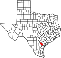
Papalote is an unincorporated community in Bee County, in the U.S. state of Texas. [1] According to the Handbook of Texas, the community had a population of 70 in 2000. It is located within the Beeville micropolitan area.

Contents

History

Papalote was first settled on Papalote Creek after land grants were given by Mexico to its early settlers. The area was split into three settlements: Lower, Central, and Upper Papalote, but the three merged into one settlement around the mid-1880s. [2]

Education

Several schools were established throughout Papalote's history, such as schools in Lower Papalote. [2] It is currently part of the Skidmore-Tynan Independent School District.

Related Research Articles

<span class="mw-page-title-main">San Antonio</span> City in Texas, United States

San Antonio, officially the City of San Antonio, is a city in the U.S. state of Texas and the most populous city in Greater San Antonio, the third-largest metropolitan area in Texas and the 24th-largest metropolitan area in the United States at 2.6 million people in the 2020 US census. It is the most populous city in and the seat of Bexar County. The city is the seventh-most populous in the United States, the second-largest in the Southern United States, and the second-most populous in Texas after Houston.

<span class="mw-page-title-main">Bee County, Texas</span> County in Texas, United States

Bee County is a county located in the U.S. state of Texas. It is in South Texas and its county seat is Beeville. As of the 2020 census, its population was 31,047. The Beeville, TX micropolitan statistical area includes all of Bee County. The county was founded December 8, 1857, and organized the next year. It is named for Barnard E. Bee, Sr., a secretary of state of the Republic of Texas.

<span class="mw-page-title-main">Lower Colorado River Authority</span> Public utility in Texas that manages the lower Colorado River

The Lower Colorado River Authority (LCRA) is a nonprofit public utility created in November 1934 by the Texas Legislature. LCRA's mission is to enhance the lives of the Texans it serves through water stewardship, energy and community service. LCRA provides public power, manages the lower Colorado River, builds and operates transmission lines, owns public parks, and offers community services.

<span class="mw-page-title-main">DeSoto, Texas</span> City in the United States

DeSoto is a city in Dallas County, Texas, United States. DeSoto is a suburb of Dallas and is part of the Best Southwest area, which includes DeSoto, Cedar Hill, Duncanville, and Lancaster.

<span class="mw-page-title-main">Deer Park, Texas</span> City in Texas, United States

Deer Park is a city in the U.S. state of Texas within the Houston–Sugar Land–Baytown metropolitan area. The city is located in Harris County and is situated in Southeast Harris County. At the 2020 U.S. census, the population of Deer Park was 34,495.

<span class="mw-page-title-main">Kingsville, Texas</span> City in Texas, United States

Kingsville is a city in the southern region of the U.S. state of Texas and the county seat of Kleberg County. Located on the U.S. Route 77 corridor between Corpus Christi and Harlingen, Kingsville is the principal city of the Kingsville Micropolitan Statistical Area, which is part of the larger Corpus Christi-Kingsville Combined Statistical Area. The population was 25,402 at the 2020 census, and in 2022 the U.S. Census Bureau estimated the population at 24,833.

<span class="mw-page-title-main">Richardson, Texas</span> City in the Dallas and Collin counties of Texas, United States

Richardson is a city in Dallas and Collin counties in the U.S. state of Texas. As of the 2020 United States census, the city had a total population of 119,469. Richardson is an inner suburb of the city of Dallas.

<span class="mw-page-title-main">Ysleta, El Paso, Texas</span> Place in Texas, United States

Ysleta is a community in El Paso, Texas, United States. Ysleta was settled between October 9 and October 12, 1680, when Spanish conquistadors, Franciscan clerics and Tigua Indians took refuge along the southern bank of the Rio Grande. These people were fleeing the Pueblo Revolt in New Mexico. Ysleta is the oldest European settlement in the area that is the present-day U.S. state of Texas.

In the United States, a colonia is a type of unincorporated, low-income, slum area located along the Mexico–United States border region that emerged with the advent of shanty towns.

<span class="mw-page-title-main">Palo Pinto, Texas</span> CDP in Texas, United States

Palo Pinto is a census-designated place (CDP) and unincorporated community and county seat in Palo Pinto County, Texas, United States. This was a new CDP for the 2010 census with a population of 333.

<span class="mw-page-title-main">Scurry, Texas</span> Town in Texas, United States

Scurry is a town in Kaufman County, Texas, United States. It was incorporated in 2003. As of the 2020 census, it had a population of 688.

<span class="mw-page-title-main">Greater Austin</span> Metropolitan Statistical Area in Texas, United States

The Austin–Round Rock–San Marcos metropolitan statistical area, or Greater Austin, is a five-county metropolitan area in the U.S. state of Texas, as defined by the Office of Management and Budget. The metropolitan area is situated in Central Texas on the western edge of the American South and on the eastern edge of the American Southwest, and borders Greater San Antonio to the south.

Tennessee Colony is an unincorporated community in Anderson County, in the U.S. state of Texas. According to the Handbook of Texas, the community had a population of 300 in 2000. It is located within the Palestine, Texas micropolitan area.

<span class="mw-page-title-main">Tavener, Texas</span> Unincorporated community^^ in Texas, United States

Tavener is an unincorporated community in Fort Bend County, Texas, United States. It is a part of the Greater Houston metropolitan area.

Montalba is an unincorporated community in central Anderson County, Texas, United States. According to the Handbook of Texas, the community had a population of 809 in 2019. It is located within the Palestine, Texas micropolitan area.

Campbellton is an unincorporated community in Atascosa County, Texas, United States. According to the Handbook of Texas, the community had an estimated population of 350 in 2000. Campbellton is part of the San Antonio Metropolitan Statistical Area.

Sand Branch is an unincorporated community in Dallas County, Texas, United States. A 2019 estimate put the population at around 100.

The Papalote Creek Wind Farm near Taft, Texas in San Patricio County is an array of 196 wind turbines that can produce 380 megawatts (MW) of power, enough to serve approximately 114,000 homes. The wind farm was built and is operated by E.ON Climate and Renewables North America.

Dallas–Fort Worth is the most populous metropolitan area of Texas, and the Southern United States. Having 7,637,387 residents at the 2020 U.S. census, the metropolitan statistical area has experienced positive growth trends since the former Dallas and Fort Worth metropolitan areas conurbated into the Metroplex. By the 2022 census estimates, its population grew to 7,943,685.

Taylorsville is an unincorporated community in Caldwell County, in the U.S. state of Texas. According to the Handbook of Texas, the community had a population of 20 in 2000. It is located within the Greater Austin metropolitan area.

References

  1. 1 2 U.S. Geological Survey Geographic Names Information System: Papalote, Texas
  2. 1 2 Caldwell, Laura. "Papalote, TX". tshaonline.org. Retrieved June 29, 2022.