Blanconia, Texas

Last updated

Blanconia, Texas
USA Texas location map.svg
Red pog.svg
Blanconia
Usa edcp location map.svg
Red pog.svg
Blanconia
Coordinates: 28°23′55″N97°24′44″W / 28.39861°N 97.41222°W / 28.39861; -97.41222
Country United States
State Texas
County Bee
Elevation
85 ft (26 m)
Time zone UTC-6 (Central (CST))
  Summer (DST) UTC-5 (CDT)
Area code 361
GNIS feature ID1378017 [1]

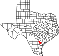
Blanconia is an unincorporated community in Bee County, in the U.S. state of Texas. [1] According to the Handbook of Texas, the community had a population of 100 in 2010. It is located within the Beeville micropolitan area.

Education

In 1905, Blanconia had a school with one teacher and 12 students. [2] Today, the community is served by the Refugio Independent School District.

Related Research Articles

<span class="mw-page-title-main">Montgomery County, Texas</span> County in Texas, United States

Montgomery County is a county in the U.S. state of Texas. As of the 2020 U.S. census, the county had a population of 620,443. The county seat is Conroe. The county was created by an act of the Congress of the Republic of Texas on December 14, 1837, and is named for the town of Montgomery. Between 2000 and 2010, its population grew by 55%, the 24th-fastest rate of growth of any county in the United States. Between 2010 and 2020, its population grew by 36%. According to the U.S. Census Bureau, the estimated population is 711,354 as of July 1, 2023.

<span class="mw-page-title-main">Robertson County, Texas</span> County in Texas, United States

Robertson County is a county in the U.S. state of Texas. As of the 2020 census, its population was 16,757. Its county seat is Franklin. The county was created in 1837 and organized the following year. It is named for Sterling C. Robertson, an early settler who signed the Texas Declaration of Independence.

<span class="mw-page-title-main">Lee County, Texas</span> County in Texas, United States

Lee County is a county located in the U.S. state of Texas. As of the 2020 census, its population was 17,478. Its county seat is Giddings. The county was founded in 1874 and is named for Confederate General Robert E. Lee. The county has many Confederate memorials and monuments to the Confederate States of America.

<span class="mw-page-title-main">Fayette County, Texas</span> County in Texas, United States

Fayette County is a county located in the U.S. state of Texas. As of the 2020 census, the population was 24,435. Its county seat is La Grange. The county was created in 1837 and organized the next year.

<span class="mw-page-title-main">Caldwell County, Texas</span> County in Texas, United States

Caldwell County is a county located in the U.S. state of Texas. As of the 2020 census, its population was 45,883. Its county seat is Lockhart. The county was founded in 1848 and named after Mathew Caldwell, a ranger captain who fought in the Battle of Plum Creek against the Comanches and against Santa Anna's armies during the Texas Revolution. Caldwell was also a signer of the Texas Declaration of Independence.

<span class="mw-page-title-main">Atascosa County, Texas</span> County in Texas, United States

Atascosa County is a county located in the U.S. state of Texas. It is in South Texas and its county seat is Jourdanton.

<span class="mw-page-title-main">McKinney, Texas</span> City in the United States

McKinney is a city in and the county seat of Collin County, Texas, United States. It is Collin County's third-largest city, after Plano and Frisco. A suburb of the Dallas–Fort Worth metroplex, McKinney is about 32 miles (51 km) north of Dallas.

<span class="mw-page-title-main">DeSoto, Texas</span> City in the United States

DeSoto is a city in Dallas County, Texas, United States. DeSoto is a suburb of Dallas and is part of the Best Southwest area, which includes DeSoto, Cedar Hill, Duncanville, and Lancaster.

<span class="mw-page-title-main">Sugar Land, Texas</span> City in the United States

Sugar Land is the largest city in Fort Bend County, Texas, United States, located in the southwestern part of the Houston–The Woodlands–Sugar Land metropolitan area. Located about 19 miles (31 km) southwest of downtown Houston, Sugar Land is a populous suburban municipality centered around the junction of Texas State Highway 6 and Interstate 69/U.S. Route 59.

<span class="mw-page-title-main">La Marque, Texas</span> City in Texas, United States

La Marque is a city in Galveston County, Texas, United States, south of Houston. The city population in 2020 was 18,030. La Marque experienced considerable growth in the 1950s, during which the city provided a general administrative and trades and crafts workforce helping to support the petrochemical complex in adjoining Texas City. It is the hometown of U.S. Senator Kay Bailey Hutchison and Norman Bulaich.

<span class="mw-page-title-main">Deer Park, Texas</span> City in Texas, United States

Deer Park is a city in the U.S. state of Texas within the Houston–Sugar Land–Baytown metropolitan area. The city is located in Harris County and is situated in Southeast Harris County. At the 2020 U.S. census, the population of Deer Park was 34,495.

<span class="mw-page-title-main">Kingsville, Texas</span> City in Texas, United States

Kingsville is a city in the southern region of the U.S. state of Texas and the county seat of Kleberg County. Located on the U.S. Route 77 corridor between Corpus Christi and Harlingen, Kingsville is the principal city of the Kingsville Micropolitan Statistical Area, which is part of the larger Corpus Christi-Kingsville Combined Statistical Area. The population was 25,402 at the 2020 census, and in 2022 the U.S. Census Bureau estimated the population at 24,833.

<span class="mw-page-title-main">The Woodlands, Texas</span> Census-designated place and special-purpose district in Texas, United States

The Woodlands is a special-purpose district and census-designated place (CDP) in the U.S. state of Texas in the Houston–The Woodlands–Sugar Land metropolitan statistical area. The Woodlands is primarily located in Montgomery County, with portions extending into Harris County. The Woodlands is governed by The Woodlands Township, an organization that provides municipal services and is administered by an elected board of directors. As of the 2020 U.S. Census, the township had a population of 114,436 people.

<span class="mw-page-title-main">Forest Hill, Texas</span> City in Texas, United States

Forest Hill is a suburb of Fort Worth in Tarrant County, Texas, United States. The population was 13,955 at the 2020 census.

<span class="mw-page-title-main">Wichita Falls, Texas</span> City in Texas, United States

Wichita Falls is a city in and the county seat of Wichita County, Texas, United States. It is the principal city of the Wichita Falls metropolitan statistical area, which encompasses all of Archer, Clay, and Wichita Counties. According to the 2020 census, it had a population of 102,316, making it the 39th-most populous city in Texas.

<span class="mw-page-title-main">Carrollton, Texas</span> City in Texas, United States

Carrollton is a city in Dallas, Denton, and Collin counties in the U.S. state of Texas. As of the 2020 census, its population was 133,434, making it the 23rd-most populous city in Texas.

<span class="mw-page-title-main">Richardson, Texas</span> City in the Dallas and Collin counties of Texas, United States

Richardson is a city in Dallas and Collin counties in the U.S. state of Texas. As of the 2020 United States census, the city had a total population of 119,469. Richardson is an inner suburb of the city of Dallas.

<span class="mw-page-title-main">Missouri City, Texas</span> City in Texas, United States

Missouri City is a city in the U.S. state of Texas, within the Houston–The Woodlands–Sugar Land metropolitan area. The city is mostly in Fort Bend County, with a small portion in Harris County. As of the 2020 census, the city had a population of 74,259, an increase over the figure of 67,358 tabulated in 2010.

<span class="mw-page-title-main">Greater Austin</span> Metropolitan Statistical Area in Texas, United States

The Austin–Round Rock–San Marcos metropolitan statistical area, or Greater Austin, is a five-county metropolitan area in the U.S. state of Texas, as defined by the Office of Management and Budget. The metropolitan area is situated in Central Texas on the western edge of the American South and on the eastern edge of the American Southwest, and borders Greater San Antonio to the south.

Rylie is a neighborhood in Dallas, Texas that was formerly an unincorporated community in Dallas County. Rylie is located between Interstate 20 and U.S. Highway 175 along a former Southern Pacific Railroad line, 11 miles (18 km) southeast of Downtown Dallas. Rylie is a part of the Southeast Dallas area.

References

  1. 1 2 U.S. Geological Survey Geographic Names Information System: Blanconia, Texas
  2. Kendall, Rebecca Leigh. "Blanconia, TX". tshaonline.org. Retrieved June 26, 2022.