This article is about the Atlantic hurricane of 1964. For other storms of the same name, see List of storms named Hilda. For the 1998 Brazilian miniseries whose title translates to "Hilda Hurricane", see Hilda Furacão.
Hurricane Hilda was a powerful tropical cyclone that ravaged areas of the United States Gulf Coast,[1] particularly Louisiana. In addition to its damage inland,the hurricane greatly disrupted offshore oil production,and at its time was the costliest tropical cyclone for Louisiana's offshore oil production. Due in part to flights made by the National Hurricane Research Laboratory,Hilda became one of the most well-documented storms meteorologically in the Atlantic.[2] Lasting for seven days as a tropical cyclone,Hilda caused US$126million in damage and 38deaths.[nb 1] It was the tenth named storm,sixth hurricane,and the fourth major hurricane of the 1964 Atlantic hurricane season.
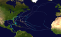
Hilda developed over the southern shores of Cuba on September28 as a tropical depression,tracking westward in an area of favorable conditions and reaching tropical storm intensity the next day. Once situated in the Gulf of Mexico,Hilda strengthened into a hurricane and began a slow trawl northward,rapidly intensifying to its peak intensity with winds of 140mph (220km/h) on October1,making it a Category4 hurricane. Slight weakening occurred as Hilda made landfall on the southern Louisiana coast on October3. After reaching land,the hurricane took a sharp turn eastward and rapidly weakened as a result of land interaction and the presence of cool,dry air. The weakened remnants of Hilda merged with a cold front a day after landfall and dissipated on October5.
Originating near Cuba,the cyclone intensified while moving through the Gulf of Mexico,and became a Category4 hurricane in the Gulf of Mexico before striking Louisiana in early October. In combination with a frontal zone located across the Southeast United States,the hurricane spread heavy rains through the South through the Carolinas into the Mid-Atlantic States. Hilda led to significant damage to oil platforms in the Gulf of Mexico,as well as $126million (1964USD) in damage,and 38 deaths.
Meteorological history
Map plotting the storm's track and intensity,according to the Saffir–Simpson scale
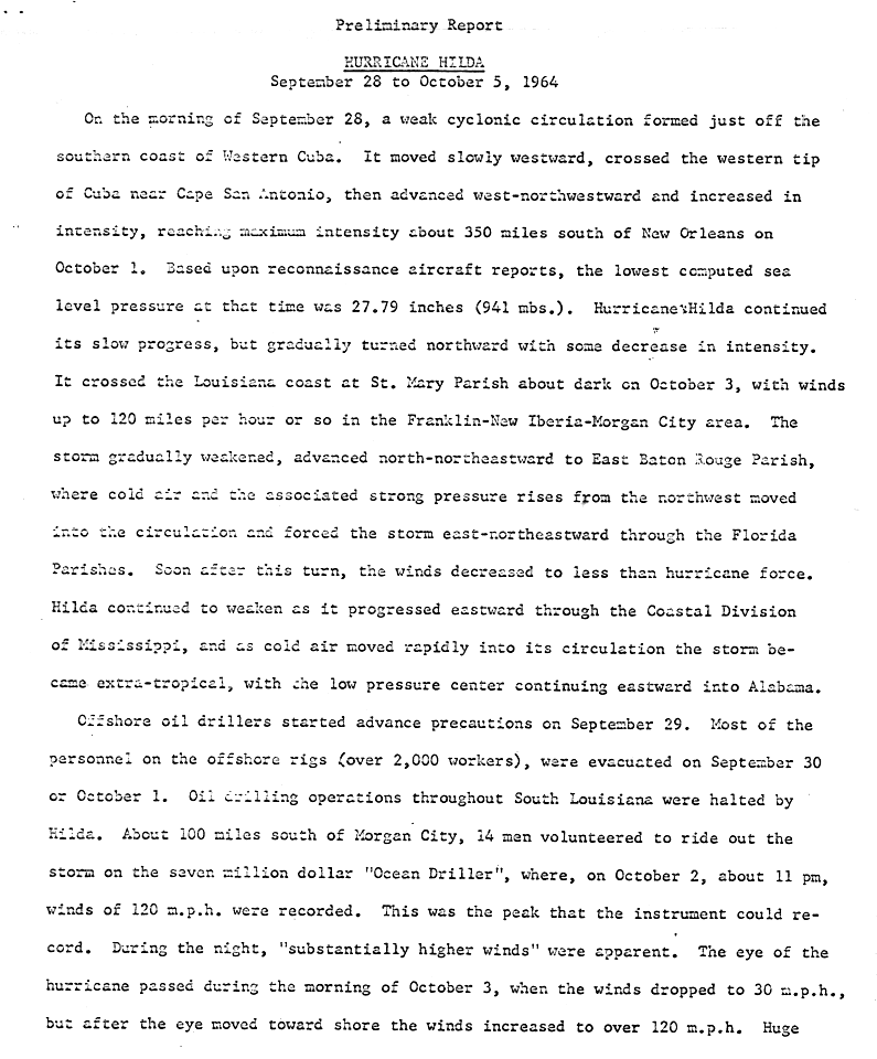
The origins of Hilda can be definitively traced back to a tropical wave that trekked across the western Caribbean Sea during the last week of September.[3] However, a loosely defined mass of clouds east of the Lesser Antilles on September23 was potentially associated with the formation of Hilda. Tracking westward, the area of convection gradually intensified, with hints at a well-defined circulation as the system tracked over Haiti on September27.[3][2] By 1200UTC on September28,[1] the disturbance had become sufficiently defined to be classified as a tropical depression south of Cuba. Tracking generally westward,[3] the depression crossed Cape San Antonio, Cuba on September29, intensifying to tropical storm strength in the meanwhile before moving into the northern Yucatán Channel. Favorable conditions for tropical cyclone development in the western Caribbean, including the presence of abnormally high sea surface temperatures, allowed for the further strengthening of Hilda.[2]
Hilda's crossing of western Cuba slightly disrupted the intensification of the tropical cyclone, but strengthening resumed shortly thereafter.[2] Upon reaching the Gulf of Mexico later of September29, Hilda began to track very slowly at an average speed of 9mph (14km/h),[3] later meeting the threshold of hurricane intensity at 1200UTC on September30.[1] During that time, atmospheric conditions over the Gulf of Mexico rapidly improved; a preexisting belt of strong wind shear, which would have inhibited further cyclonic strengthening, disintegrated coincident with Hilda's passage of the gulf.[2]Rapid intensification ensued on October1, and by 0600UTC that day Hilda became a major hurricane.[1][nb 2] Twelve hours later, the hurricane reached its peak intensity with maximum sustained winds of 140mph (220km/h) and a minimum barometric pressure of 941mbar (27.8inHg) based on reconnaissance flights.[2][1] During this phase the storm was centered roughly 350mi (560km) south of New Orleans, Louisiana.[3] Around the same time, an abnormally strong trough centered over Mississippi began to sharply curve the forward motion of Hilda towards the north.[5]
TIROS VIII image of Hilda near Louisiana on October2
Following peak intensity, further strengthening was inhibited due to the emergence of a high pressure area over the United States Gulf Coast. The presence of this system injected dry air into Hilda, gradually weakening the hurricane. The once prominent eye of the storm clouded over as a result of this advection.[6] During the evening hours of October3,[3] around 23:00UTC, Hilda made landfall on the central Louisiana coast near Calumet with a minimum pressure of 959mbar (28.3inHg) and maximum sustained winds of 105mph (169km/h), making a Category2 hurricane on the modern-day Saffir–Simpson hurricane wind scale.[7][8] Rapid weakening followed landfall as a result of the surrounding cold air;[6] by 0600UTC on October4, Hilda had been downgraded to tropical storm intensity.[1] The same area of high pressure which had weakened the tropical cyclone later forced Hilda eastward,[5][6] resulting in the storm's merging with a cold front and thus transitioning into an extratropical cyclone later that day.[6][1] These extratropical remnants continued to track eastward before they were last noted north of The Bahamas on October7.[1]
Preparations
The first hurricane watches or warnings issued by the Weather Bureau in association with Hilda were issued on October1, when the agency issued a hurricane watch for the coast of Louisiana to Mobile, Alabama. This prompted the Texas Department of Public Safety to issue a standby alert for the Texas coast.[9] On October3, the Weather Bureau upgraded the watch to a hurricane warning, and expanded it to include the entire Texas Coastal Bend eastward to Mobile, Alabama.[10] As Hilda neared the coast, the scope of the warning was narrowed to include only areas of the Louisiana Gulf Coast eastward to Mobile, Alabama and a gale warning for an extent of the United States Gulf Coast from Mobile Bay to Panama City, Florida.[11] By the afternoon of October4, hurricane warnings were lowered but gale warnings remained in place.[12]
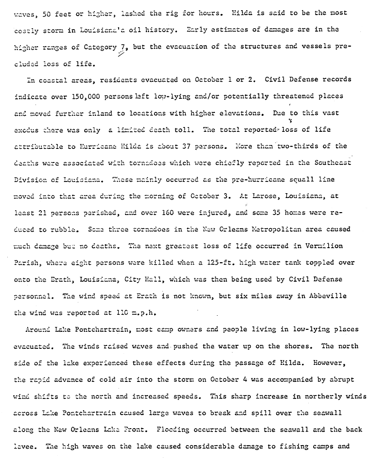
Evacuation of offshore oil platforms began as early as September29. The majority of the 2,000oil workers were evacuated on September30 and October1.[13] Along the United States Gulf Coast, approximately 150,000people evacuated.[14] The U.S. Office of Civil Defense and three companies of the Louisiana National Guard were assigned to areas of the coast expedite the evacuation process.[15] Areas lining Lake Pontchartrain were almost entirely evacuated.[14] Re-purposed boxcars were used to move 3,400evacuees northward from New Orleans and Franklin, Louisiana.[15] A mandatory evacuation order was placed for a 23mi (37km) section of the coast of St. Mary Parish, Louisiana, with shuttle buses assisting in evacuating refugees to Opelousas, Louisiana. The United States Red Cross transported 10,000cots to evacuation centers in Opelousas to serve the evacuees.[16]Morgan City and Cameron, Louisiana were sites of mass exodus with Hilda approaching the coast.[10] Evacuation out of Cameron was disrupted by the lack of a bridge across the Intracoastal Waterway, and thus had to be conducted via ferry.[17] Heads of cattle were among those evacuating from Cameron Parish in fears of a repeat of Hurricane Audrey, which had killed 35,000cattle.[15] Similarly, all residents of Pecan Island, Louisiana were evacuated.[18] In Grand Isle, Louisiana, approximately 80%of the population evacuated.[17]
The motor shipCornelia B III, carrying a truck on deck, encountered Hilda's rough surf and winds as it traversed the Gulf of Mexico, resulting in the truck being washed overboard.[20] As Hilda tracked northward through the Gulf of Mexico, the storm threatened an estimated $350million worth of offshore oil drilling facilities. Hilda would become the most destructive tropical cyclone to Louisiana's offshore oil industry at the time of its impact, accruing losses over $100million. Strong winds and heavy surf destroyed thirteenoil platforms and damaged fivebeyond repair.[21] All but one of the lost oil rigs were built to withstand a "25-year storm", with the other constructed to withstand a "100-year storm".[22]Oil spills resulting from the affected rigs released 11,869barrels of crude oil into the gulf.[23] Despite widespread evacuation of offshore drilling platforms, the 14crewmembers of the Ocean Driller managed to ride out the storm, at times withstanding winds as high as 120mph (190km/h).[24]
The majority of deaths associated with Hilda in Louisiana were a result of tornadoes spawned by the hurricane in its outer peripheral rainbands and squall lines, which began tracking across the region on October3.[14] Six tornadoes and two waterspouts occurred in Louisiana due to the hurricane. Despite tracking for only 1–1.5mi (1.6–2.4km) near Larose, Louisiana, a violent F4 tornado killed 22people and injured 165others, destroying 35homes in the process. Automobiles in the path of the twister were also damaged. Debris picked up by the tornado was found 16mi (26km) away in the Coteau-Bayou Blue area, or 3 miles east of Houma. This was the second of only two violent tornado ever spawned by a hurricane with the first one coming from Hurricane Carla in 1961. No other tornado in the state resulted in deaths, though multiple twisters in the New Orleans metropolitan area caused extensive damage to several automobiles and buildings and injured five.[25] The same tornadoes also knocked down power lines, knocking out power in localized areas. KLEB was knocked off the air as a result of these outages.[15]
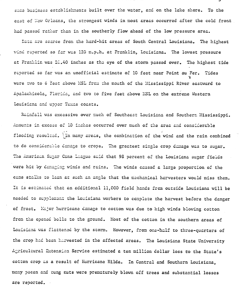
Data from the hardest hit areas along the central Louisiana coast remains sparse due to the small population density of the area. Storm surge unofficially peaked at 10ft (3.0m) at the Point Au Fer Reef Light. At the mouth of the Mississippi River, tides reached as high as 6ft (1.8m) above mean sea level. The strongest wind report was from Franklin, Louisiana, where a station clocked sustained winds of 120mph (190km/h). Near the coast in Erath, a 125ft (38m) high water tower succumbed to Hilda's strong winds and collapsed onto an adjacent town hall where civil defense personnel were operating.[14] The incident resulted in the deaths of eight and six injuries.[25] Although there were no stations to report the intensity of winds in Erath, winds 6mi (9.7km) away in Abbeville reached 110mph (175km/h).[14] Hilda's sharp curve eastward after landfall and the advection of cold air from the north resulted in gusty winds over the New Orleans area, causing waves to break and spill over the seawall protecting the city from Lake Pontchartrain. The resulting waterfront flooding damaged fishing camps and other shoreline property.[14][26] Elsewhere in southeastern Louisiana, strong winds stripped pecans and other nuts off of trees.[26]
Despite Hilda's intensity at landfall,[1] much of the damage attributed to the hurricane was a result of heavy rains associated with the storm and its interaction with a nearby frontal boundary.[26][27] Rainfall caused by the storm peaked at 17.71in (450mm) northwest of Jeanerette. The strong winds and rain caused extensive crop damage; 98%of Louisiana's sugar crop sustained some measure of damage. Although most of the state's cotton crop was harvested prior to Hilda's landfall, the heavy rains flattened unpicked cotton in southern Louisiana, resulting in US$10million in damage.[26] Overall, the effects of Hilda in Louisiana destroyed or heavily damaged nearly 2,600residences and inflicted minor damage on an additional 19,000. The United States Red Cross estimated that about 5,000people were injured and that of those 357were hospitalized.[25]
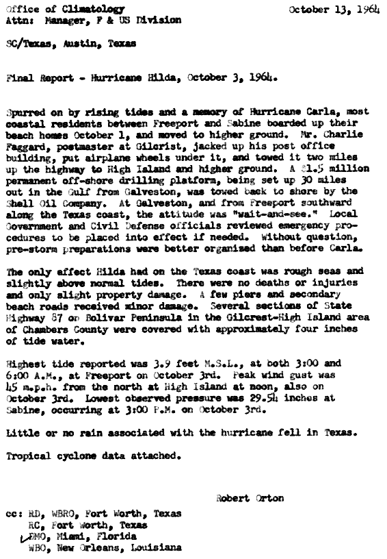
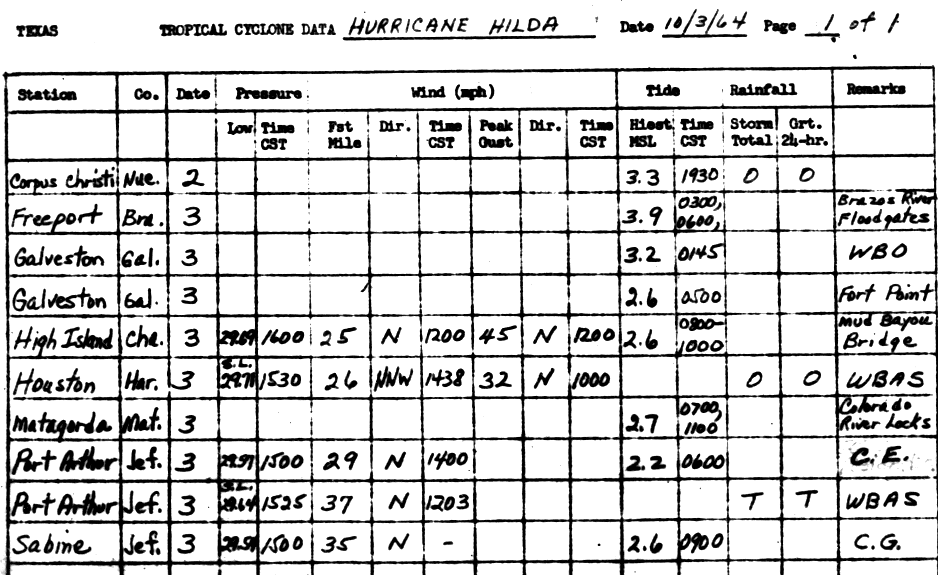
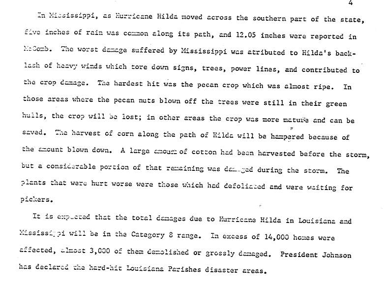
Effects in Texas were minimal, with gusts peaking at 45mph (72km/h) near High Island, Texas and areas of the state receiving trace amounts of precipitation at most.[19][31] Damage was limited to the portions of the coast which were hit by a minor storm surge peaking at 3.9ft (1.2m) above mean sea level at Freeport. Some piers and arterial beach roads adjacent to the coast were damaged. Portions of Texas State Highway 87 on the Bolivar Peninsula were inundated by floodwater. Minor property damage occurred, and no persons were injured in Texas.[19] Tracking across the southern areas of Mississippi,[32] Hilda and later its remnants brought torrential rainfall to central and southern portions of the state.[25] The McComb-Pike County Airport received 12.57in (319mm) of rain, the highest precipitation total statewide.[28] The heavy rains resulted in record rainfall totals for the month of October in several locations and flash floods. However, the majority of damage in the state was a result of strong northerly winds, which caused power outages and was destructive to the state's pecan and corn crops, which had been nearing harvest. Cotton crops that were harvested prior to the passage of Hilda were largely damaged. Power outages knocked out 460telephone circuits and over 30,000individual telephones. Strong winds also uprooted and felled trees and their limbs in addition to as well as a 200ft (61m) tall radio mast near Moss Point, Mississippi. As a result of Hilda, 20people were injured and damage exceeded $50,000. Three of those injuries were a result of a tornado which struck areas of Pearl River County, destroying a home, two barns, and a pumping station.[25] Across Mississippi, over 14,000homes were damaged, of which 3,000were either heavily damaged or completely destroyed.[32]
Interacting with a cold front as it traversed Alabama, the remnants of Hilda caused gusts as strong as 80mph (130km/h) in Mobile and Baldwin counties, downing telecommunication lines, uprooting trees, and shattering windows. Piers lining Mobile Bay were either destroyed or damaged. Five people were injured in those two counties. Strong winds in Russell and Lee counties damaged or destroyed several buildings, injuring four. In addition to straight-line winds, three tornadoes occurred across six counties in Alabama, with one injuring three people after damaging five homes, a hospital, and a plant.[25] Although rainfall peaked well inland at 8.91in (226mm),[28] damage as a result of rain was limited to the coast, where the combination of high tides and rain resulted in minor coastal inundation. As the remnants of Hilda moved across the Florida Panhandle on October4–5, rough surf was produced, with high tides causing minor tidal inundation along the Florida coast.[25] One person drowned in the high surf produced by the storm off of Pensacola, Florida on October4. Squalls in western and northern Florida produced heavy rain,[25] with a maximum occurring in Wewahitchka, which received 12.42in (315mm).[33] The precipitation produced localized flooding in the Tallahassee area. The squalls also produced strong winds, at times gusting to 60mph (97km/h) near Pensacola. A station at Naval Air Station Pensacola clocked a 59mph (95km/h) gust. These winds caused minor damage limited to uprooted trees and broken limbs.[25]
East Coast
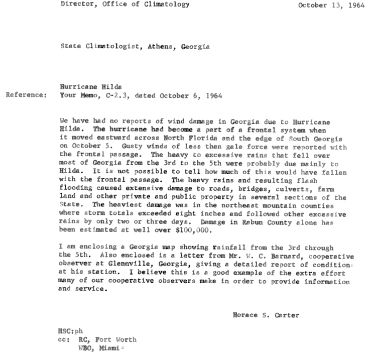
Rainfall from the remnants of Hilda extended as far northeast as Delaware as a result of the remnants interacting with a frontal boundary that extended across the United States East Coast.[27] Extremely torrential rains fell over Georgia,[25] peaking at 12.73in (323mm) south of Waynesboro.[29] The largest precipitation totals occurred in the state's northeastern extremities, where widespread totals of 8in (200mm) or higher were reported.[34] The rains resulted in flash flooding, causing extensive damage to roads and other infrastructure across Georgia.[35] The excess floodwater caused streams to overflow their banks. At least 30bridges were washed away by these swollen streams, and several county roads were washed out.[25] The most considerable damage was reported in northeastern Georgia, coincident with the high rainfall totals there. Damage in Rabun County alone exceeded US$100,000.[35] In addition to infrastructure damage, thousands of acres of farmland were inundated.[25]
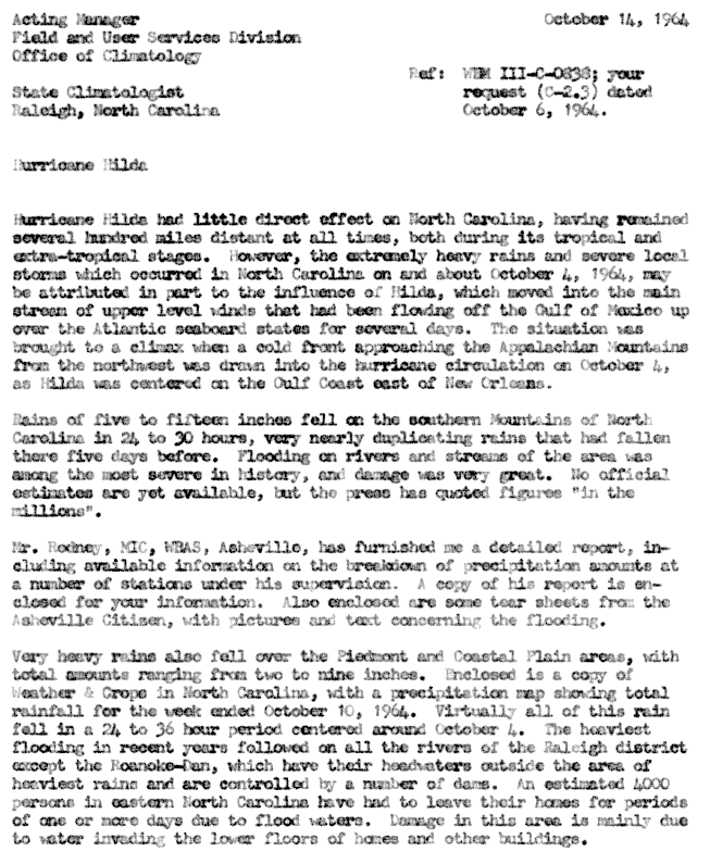
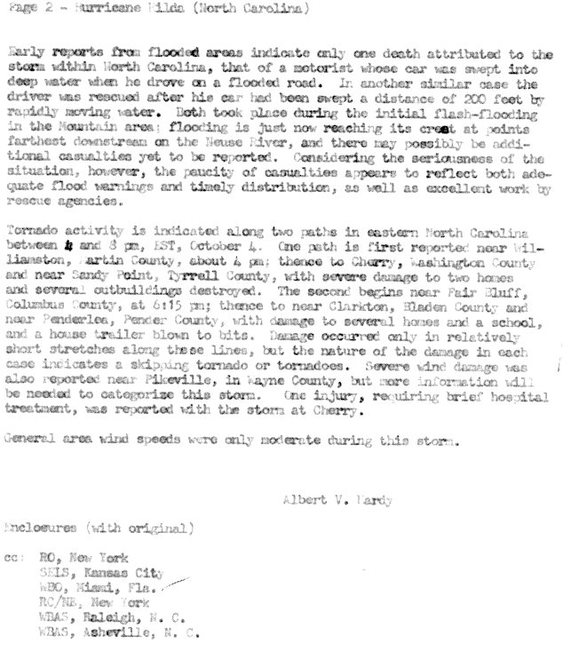
Torrential rainfall continued northeastwards into the Carolinas, with statewide rainfall peaking at 11.66in (296mm) and 12.02in (305mm) in North and South Carolina, respectively.[29] The rains in North Carolina exacerbated preexisting flood conditions which had previously caused widespread agricultural and infrastructural damage as well as soil erosion.[25] Though not directly a result of Hilda's remnants, they were likely influenced by the storm's interaction with a frontal boundary. Already overflowing rivers and streams rose even further, reaching near-record levels. Raleigh experienced severe flooding, and roughly 4,000people were forced to evacuate their homes due to dangerous floodwaters.[36] Two cars in mountainous regions were swept into inundated areas during the floods, resulting in one death.[37] Several tornadoes in six counties were also reported, injuring two.[25] Extensive wind damage was reported in Wayne County.[37]
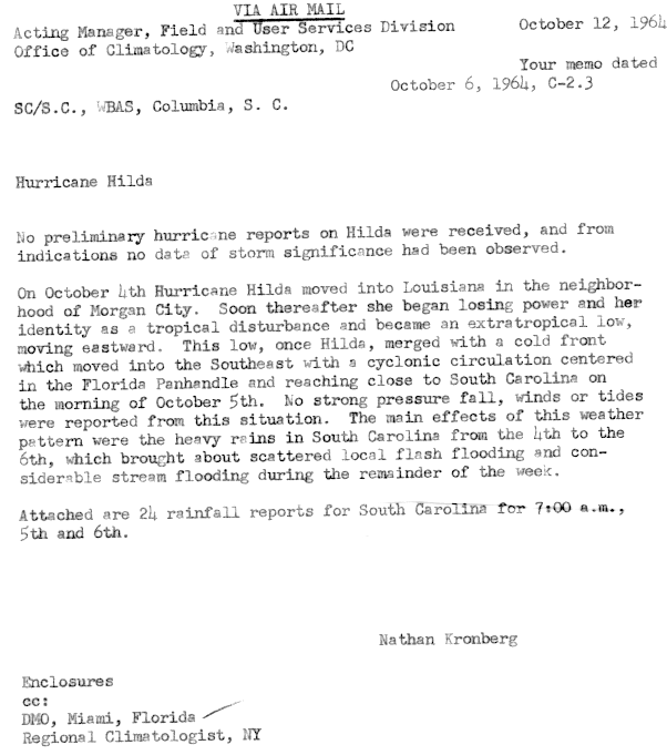
Heavy rains in South Carolina from October4–6 resulted in localized flash flooding, particularly near streams.[38] In mountainous regions, runoff from precipitation caused the Keowee, Saluda, and tributaries of the Broad River to swell, inundated and causing substantial damage to adjacent agricultural land and roads, in addition to breaching several small dams. The flooding triggered landslides, killing one person. Counties in the coastal plains of South Carolina also experienced farmland, road, and residential damage due to the heavy rains.[25]
After the season, the Weather Bureau retired the name Hilda from future use in the Atlantic basin.[39] It was replaced with Hannah for the 1968 season.[40]
Hurricane Betsy (1965) – was the first Atlantic tropical cyclone to accrue over US$1billion in damage; devastated portions of Louisiana, particularly New Orleans, less than one year later
Hurricane Carmen (1974) – resulted in tidal flooding along the U.S. Gulf Coast and greatly damaged Louisiana's sugar cane crop
Hurricane Georges (1998) – took a very similar track eastwards across the Gulf States after making landfall near New Orleans
Hurricane Lili (2002) – caused severe damage to Louisiana's southern barrier islands and disrupted oil production in the Gulf of Mexico
↑Landsea, Chris (June 1, 2017). "E23) What is the complete list of continental U.S. landfalling hurricanes?". Frequently Asked Questions. United States National Oceanic and Atmospheric Administration's Atlantic Oceanographic and Meteorological Laboratory. Archived from the original on October 27, 2005. Retrieved April 22, 2018.
12"Hurricane Hilda Veers To North". The Daily News Of Virgin Islands. No.108143. Charlotte Amalie, Virgin Islands. Associated Press. October 3, 1964. p.2. Retrieved 8 June 2014.
↑National Research Council Committee on Assessment of Safety of OCS Activities; Lee, Griff C. (1981). "Hurricane Losses". Safety and Offshore Oil: Background Papers of the Committee on Assessment of Safety of OCS Activities. Washington, D.C.: National Academies. pp.201–2.
123456789101112131415Hodges, Luther H.; White, Robert M. (October 1964). "October 1964"(PDF). Storm Data. 6 (10). Asheville, North Carolina: United States National Oceanic and Atmospheric Administration's National Climatic Data Center. Archived from the original(PDF) on 8 June 2014. Retrieved 8 June 2014.
12Roth, David M. "Hurricane Hilda- September28– October5, 1964". Tropical Cyclone Point Maxima. Silver Springs, Maryland: United States National Oceanic and Atmospheric Administration's Weather Prediction Center. Retrieved 10 June 2014.
12345Roth, David M. "Tropical Cyclone Rainfall for the Gulf Coast". Tropical Cyclone Point Maxima. Silver Springs, Maryland: United States National Oceanic and Atmospheric Administration's Weather Prediction Center. Retrieved 8 June 2014.
123456Roth, David M. "Tropical Cyclone Rainfall for the Southeast". Tropical Cyclone Point Maxima. Silver Springs, Maryland: United States National Oceanic and Atmospheric Administration's Weather Prediction Center. Retrieved 10 June 2014.
123Roth, David M. "Tropical Cyclone Rainfall in the Mid-Atlantic". Tropical Cyclone Point Maxima. Silver Springs, Maryland: United States National Oceanic and Atmospheric Administration's Weather Prediction Center. Retrieved 6 July 2014.
↑Roth, David M. "Tropical Cyclone Rainfall for Florida". Tropical Cyclone Point Maxima. Silver Springs, Maryland: United States National Oceanic and Atmospheric Administration's Weather Prediction Center. Retrieved 8 June 2014.
12Carter, Horace S. (October 6, 1964). "Hurricane Hilda, October 3–5, 1964 (Athens, Georgia)"(GIF). Athens, Georgia: United States National Oceanic and Atmospheric Administration's National Hurricane Center. Retrieved 10 June 2014.
↑National Hurricane Operations Plan 1968(PDF) (Report). Washington, D.C.: Interdepartmental Committee for Meteorological Services. May 1968. p.61. Retrieved April 3, 2024.
Sources
International Best Track Archive for Climate Stewardship (IBTrACS) (May 2021). IBTrACS browser (hosted by UNC Asheville) (Report). National Centers for Environmental Information– via World Data Center for Meteorology.
This page is based on this Wikipedia article Text is available under the CC BY-SA 4.0 license; additional terms may apply. Images, videos and audio are available under their respective licenses.


