The 1959 Atlantic hurricane season featured near normal tropical cyclone activity overall. The season officially began on June 15, 1959 and lasted until November 15, 1959. These dates historically described the period in each year when most tropical cyclogenesis occurs in the Atlantic basin. However, the formation of a tropical cyclone is possible at any time of the year, as shown in 1959, by the formation of Tropical Storm Arlene on May 28. Arlene struck Louisiana and brought minor flooding to the Gulf Coast of the United States. The next tropical storm, Beulah, formed in the western Gulf of Mexico and brought negligible impact to Mexico and Texas. Later in June, an unnamed hurricane, caused minor damage in Florida, and then devastated parts of Maritime Canada, resulting in what became known as the Escuminac disaster. Hurricane Cindy brought minor impact to The Carolinas. In late July, Hurricane Debra produced flooding in the state of Texas. Tropical Storm Edith in August and Hurricane Flora in September caused negligible impact on land.

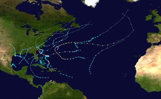
The 1961 Atlantic hurricane season was a very active Atlantic hurricane season, with an accumulated cyclone energy (ACE) total of 189, the highest since 1950 and until being surpassed by 1995. The season, however, was an average one in terms of named storms. The season featured eight hurricanes and a well above average number of five major hurricanes. It was previously thought that the season had a record-tying seven major hurricanes, before the Atlantic hurricane reanalysis project downgraded two storms in 2019. Two Category 5 hurricanes were seen in 1961, making it one of only eight Atlantic hurricane seasons to feature multiple Category 5 hurricanes in one season. The season started on June 15, and ended on November 15. These dates conventionally delimit the period of each year when most tropical cyclones form in the Atlantic basin. The first system, an operationally unclassified tropical depression, formed offshore east Central Florida on June 10, but dissipated a few days later. Next, Hurricane Anna developed in the eastern Caribbean Sea near the Windward Islands on July 20. It brought minor damage to the islands in, as well as wind and flood impacts to Central America after striking Belize as a hurricane. Anna caused one death and about $300,000 (1961 USD) in damage. Activity went dormant for nearly a month and a half, until Hurricane Betsy developed on September 2. Betsy peaked as a Category 4 hurricane, but remained at sea and caused no impact.

The 1963 Atlantic hurricane season was a slightly below average season in terms of tropical cyclone formation, with a total of ten nameable storms. Even so, it was also a notoriously deadly and destructive season. The season officially began on June 15, 1963, and lasted until November 15, 1963. These dates conventionally delimit the period of each year when most tropical cyclones form in the Atlantic basin. The first system, an unnamed tropical storm, developed over the Bahamas on June 1.

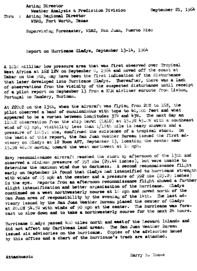
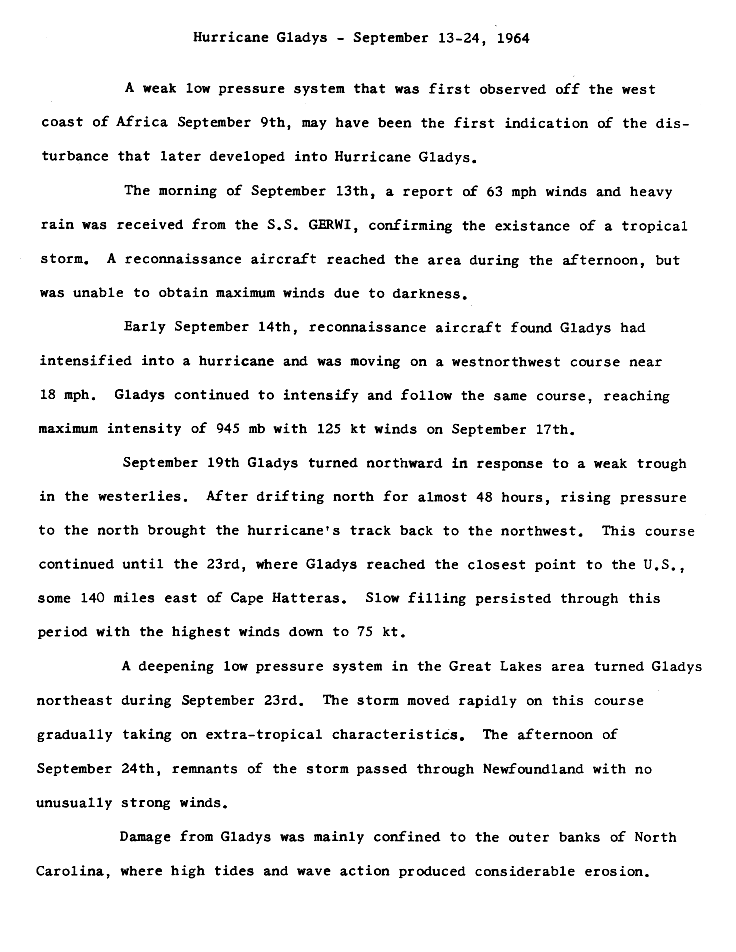
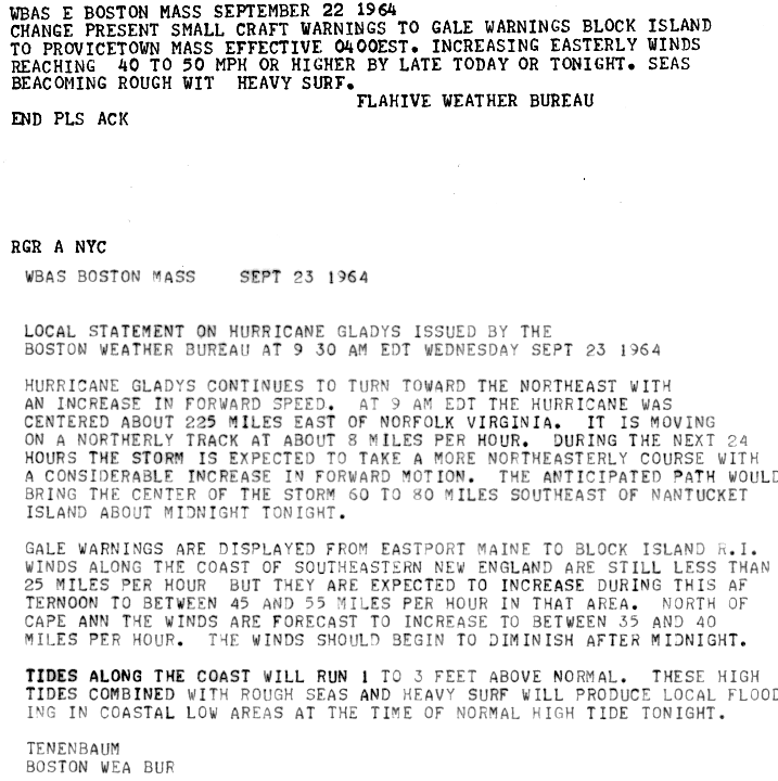
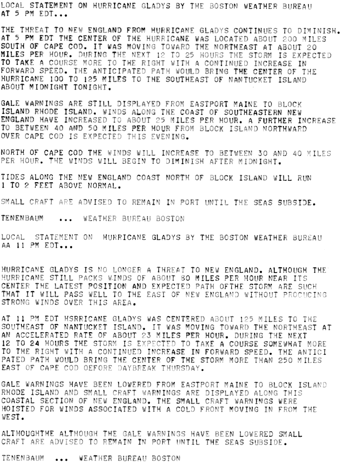
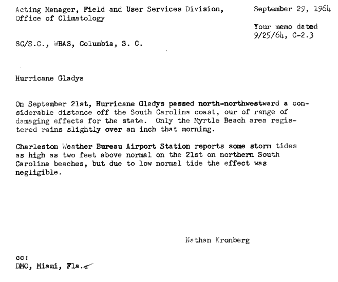
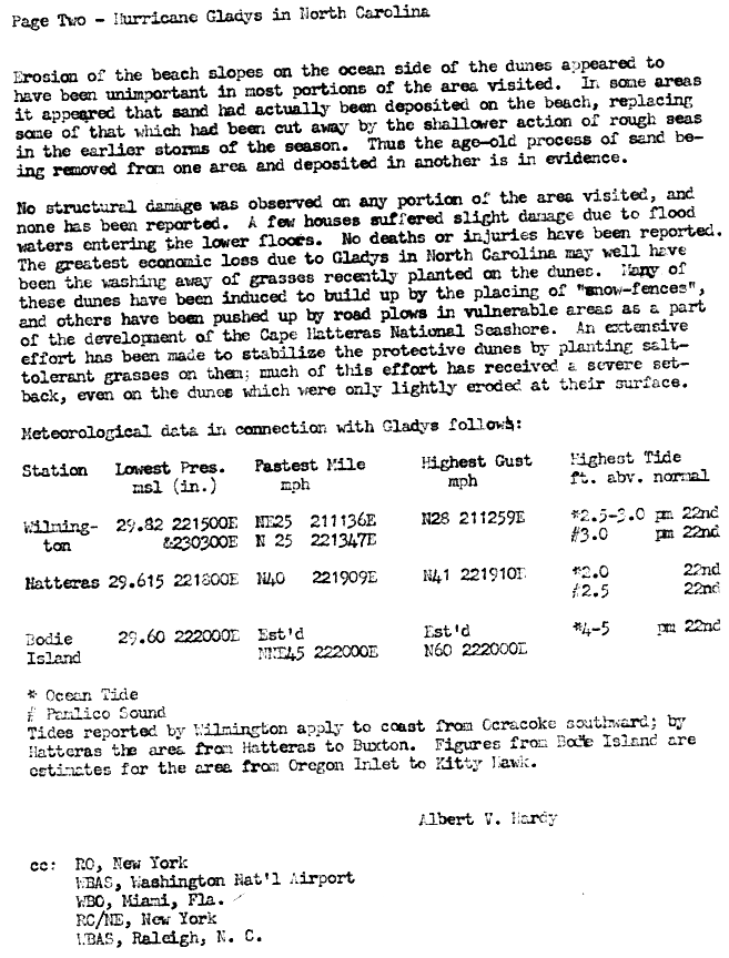
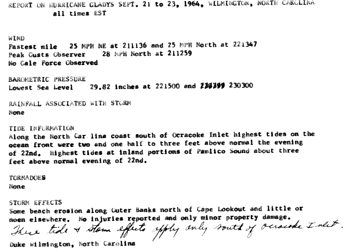
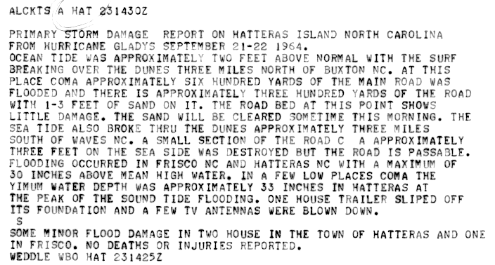
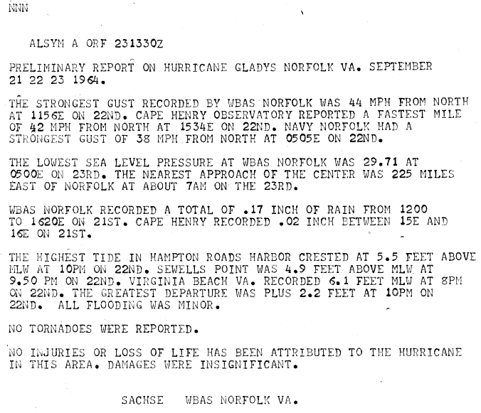
The 1964 Atlantic hurricane season featured the highest number of U.S.-landfalling hurricanes since 1933. The season officially began on June 15, and lasted until November 30. These dates conventionally delimit the period of each year when most tropical cyclones form in the Atlantic basin. The season was above average, with thirteen named storms, seven hurricanes, and five major hurricanes. The first system, an unnamed tropical storm, developed on June 2, almost two weeks before the official start of the season. Striking Florida on June 6, the storm brought localized flooding to portions of Cuba and the Southeastern United States, leaving about $1 million in damage. The next storm, also unnamed, developed near the end of July; it did not impact land.

The 1965 Atlantic hurricane season was the first to use the modern-day bounds for an Atlantic hurricane season, which are June 1 to November 30. These dates conventionally delimit the period of each year when most tropical cyclones form in the Atlantic basin. It was a slightly below average season, with 10 tropical cyclones developing and reaching tropical storm intensity. Four of the storms strengthened into hurricanes. One system reached major hurricane intensity – Category 3 or higher on the Saffir–Simpson hurricane scale. The first system, an unnamed tropical storm, developed during the month of June in the southern Gulf of Mexico. The storm moved northward across Central America, but caused no known impact in the region. It struck the Florida Panhandle and caused minor impact across much of the Southern United States. Tropical cyclogenesis halted for over two months, until Anna formed on August 21. The storm remained well away from land in the far North Atlantic Ocean and caused no impact.

The 1968 Atlantic hurricane season was a below average hurricane season during which only nine nameable storms developed. The season officially began on June 1 and lasted until November 30, dates which conventionally delimit the period of each year when most tropical cyclones form in the Atlantic basin. Of the named storms, five strengthened into hurricanes; none however intensified into a major hurricane. Only four other seasons since the start of the satellite era—1972, 1986, 1994, and 2013—did not feature a major hurricane. The first system, Hurricane Abby, developed in the northwestern Caribbean on June 1. Abby moved northward and struck Cuba, bringing heavy rainfall and flooding to western portions of the island. Making landfall in Florida on June 4, Abby caused flooding and spawned four tornadoes, but left behind little damage. Overall, the hurricane resulted in six deaths and about $450,000 (1968 USD) in damage. In late June, Tropical Storm Candy brought minor flooding and spawned several tornadoes across portions of the Southern United States. Overall damage from the cyclone reached approximately $2.7 million. 1968 featured two simultaneously active tropical storms during the month of June, a phenomenon that would not occur again until 2023.

The 1975 Atlantic hurricane season was a near average hurricane season with nine named storms forming, of which six became hurricanes. Three of those six became major hurricanes, which are Category 3 or higher systems on the Saffir–Simpson scale. The season officially began on June 1 and lasted until November 30. These dates conventionally delimit the period of each year when most tropical cyclones form in the Atlantic Ocean.

The 1955 Atlantic hurricane season was, at the time, the costliest season ever recorded, just ahead of the previous year. The hurricane season officially began on June 15, 1955, and ended on November 15, 1955. It was an extremely active season in terms of accumulated cyclone energy (ACE), but only slightly above average in terms of storm formation, with 13 recorded tropical cyclones.
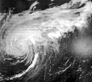
Hurricane Faith was a long-lived Cape Verde hurricane and was the sixth named storm and fifth hurricane of the 1966 Atlantic hurricane season. Faith developed from an area of disturbed weather between Cape Verde and the west coast of Africa on August 21. Tracking westward, the depression gradually intensified and became Tropical Storm Faith on the following day. Moving westward across the Atlantic Ocean, it continued to slowly strengthen, reaching hurricane status early on August 23. Over the next several days, the storm treked north of the Lesser Antilles, weakening into a tropical storm on August 26. Located near the Lesser Antilles, the outer bands of Faith produced gale-force winds in the region, especially Puerto Rico, the Virgin Islands, and Antigua. Minor coastal damage occurred as far south as Trinidad and Tobago.

The 1951 Atlantic hurricane season was the first hurricane season in which tropical cyclones were officially named by the United States Weather Bureau. The season officially started on June 15, when the United States Weather Bureau began its daily monitoring for tropical cyclone activity; the season officially ended on November 15. It was the first year since 1937 in which no hurricanes made landfall on the United States; as Hurricane How was the only tropical storm to hit the nation, the season had the least tropical cyclone damage in the United States since the 1939 season. As in the 1950 season, names from the Joint Army/Navy Phonetic Alphabet were used to name storms this season.

The 1949 Atlantic hurricane season was the last season that tropical cyclones were not publicly labeled by the United States Weather Bureau. It officially began on June 15, and lasted until November 15. These dates conventionally delimit the period of each year when most tropical cyclones form in the Atlantic basin. The first storm, a tropical depression, developed in the northern Gulf of Mexico on August 14. The final system, Tropical Storm Sixteen, dissipated in the southwestern Caribbean Sea on November 5. It was a fairly active season, featuring 16 tropical storms and seven hurricanes. Two of these strengthened into major hurricanes, which are Category 3 or higher on the Saffir–Simpson hurricane wind scale.

The 1947 Atlantic hurricane season was the first Atlantic hurricane season to have tropical storms labeled by the United States Air Force. The season officially began on June 16, 1947, and ended on November 1, 1947. These dates conventionally delimit the period of each year when most tropical cyclones form in the Atlantic basin. However, the first tropical cyclone developed on June 13, while the final system was absorbed by a cold front on December 1. There were 10 tropical storms; 5 of them attained hurricane status, while two became major hurricanes, which are Category 3 or higher on the modern day Saffir–Simpson scale. Operationally, the third tropical storm was considered two separate tropical cyclones, resulting in the storm receiving two names. The eighth tropical storm went undetected and was not listed in HURDAT until 2014.

The 1919 Atlantic hurricane season was among the least active hurricane seasons in the Atlantic on record, featuring only five tropical storms. Of those five tropical cyclones, two of them intensified into a hurricane, with one strengthening into a major hurricane Two tropical depressions developed in the month of June, both of which caused negligible damage. A tropical storm in July brought minor damage to Pensacola, Florida, but devastated a fleet of ships. Another two tropical depressions formed in August, the first of which brought rainfall to the Lesser Antilles.

The 1915 Atlantic hurricane season was an active Atlantic hurricane season in which six tropical storms developed. The first storm, which remained a tropical depression, appeared on April 29 near the Bahamas, while the final system, also a tropical depression, was absorbed by an extratropical cyclone well south of Newfoundland on October 22. Of the six tropical storms, five intensified into a hurricane, of which three further strengthened into a major hurricane. Four of the hurricanes made landfall in the United States. The early 20th century lacked modern forecasting and documentation, and thus, the hurricane database from these years may be incomplete.
The 1908 Atlantic hurricane season was an active Atlantic hurricane season. Thirteen tropical cyclones formed, of which ten became tropical storms; six became hurricanes, and one of those strengthened into a major hurricane – tropical cyclones that reach at least Category 3 on the modern day Saffir–Simpson scale. The season's first system developed on March 6, and the last storm transitioned into an extratropical cyclone on October 23.

The 1905 Atlantic hurricane season featured five known tropical cyclones, two of which made landfall in the United States. The first system was initially observed near the Windward Islands on September 6. The last system to dissipate, the fourth storm, transitioned into an extratropical cyclone on October 11, while located well southeast of Newfoundland. These dates fall within the period with the most tropical cyclone activity in the Atlantic. Between October 5 and October 10, the fourth and fifth system existed simultaneously.

The 1901 Atlantic hurricane season was the most active season without a major hurricane – tropical cyclones that reach at least Category 3 on the Saffir–Simpson hurricane wind scale – until 2013. The first system was initially observed in the northeastern Caribbean on June 11. The fourteenth and final system transitioned into an extratropical cyclone near Bermuda on November 5. These dates fall within the period with the most tropical cyclone activity in the Atlantic. Eight of the fourteen tropical cyclones existed simultaneously.

The 1899 Atlantic hurricane season featured the longest-lasting tropical cyclone in the Atlantic basin on record. There were nine tropical storms, of which five became hurricanes. Two of those strengthened into major hurricanes, which are Category 3 or higher on the modern day Saffir–Simpson scale. The first system was initially observed in the northeastern Gulf of Mexico on June 26. The tenth and final system dissipated near Bermuda on November 10. These dates fall within the period with the most tropical cyclone activity in the Atlantic. In post-season analysis, two tropical cyclones that existed in October were added to HURDAT – the official Atlantic hurricane database. At one point during the season, September 3 through the following day, a set of three tropical cyclones existed simultaneously.

The 1897 Atlantic hurricane season was an inactive season, featuring only six known tropical cyclones, four of which made landfall. There were three hurricanes, none of which strengthened into major hurricanes, which are Category 3 or higher on the modern-day Saffir–Simpson hurricane wind scale. The first system was initially observed south of Cape Verde on August 31, an unusually late date. The storm was the strongest of the season, peaking as a Category 2 hurricane with winds of 100 mph (155 km/h). While located well north of the Azores, rough seas by the storm sunk a ship, killing all 45 crewmen. A second storm was first spotted in the Straits of Florida on September 10. It strengthened into a hurricane and tracked northwestward across the Gulf of Mexico, striking Louisiana shortly before dissipating on September 13. This storm caused 29 deaths and $150,000 (1897 USD) in damage.

The 1893 Atlantic hurricane season was a fairly active season, with 12 tropical storms forming, 10 of which became hurricanes. Of those, five became major hurricanes. It has the third highest accumulated cyclone energy on record for Atlantic hurricane season, totaling 231. This season proved to be a very deadly season, with two different hurricanes each causing over 2,000 deaths in the United States; at the time, the season was the deadliest in U.S. history. The season was one of two seasons on record to see four Atlantic hurricanes active simultaneously, along with the 1998 Atlantic hurricane season. Additionally, August 15, 1893 was the only time since the advent of modern record keeping that three storms have formed on the same day until 2020 saw Wilfred, Alpha, and Beta forming on the same day; and for the first time, there were two high-intensity hurricanes simultaneously in one month of August, and this was not repeated until the year 2023.


