
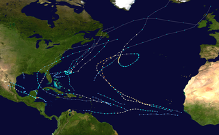
The 1995 Atlantic hurricane season was a very active Atlantic hurricane season, and is considered to be the start of an ongoing era of high-activity tropical cyclone formation. The season produced twenty-one tropical cyclones, nineteen named storms, as well as eleven hurricanes and five major hurricanes. The season officially began on June 1 and ended on November 30, dates which conventionally delimit the period of each year when most tropical cyclones develop in the Atlantic basin. The first tropical cyclone, Hurricane Allison, developed on June 2, while the season's final storm, Hurricane Tanya, transitioned into an extratropical cyclone on November 1. The very active Atlantic hurricane activity in 1995 was caused by La Niña conditions, which also influenced an inactive Pacific hurricane season. It was tied with 1887 Atlantic hurricane season with 19 named storms, which was later equalled by the 2010, 2011, and 2012 seasons.

The 1966 Atlantic hurricane season saw the Weather Bureau office in Miami, Florida, be designated as the National Hurricane Center (NHC) and assume responsibility of tropical cyclone forecasting in the basin. The season officially began on June 1, and lasted until November 30. These dates conventionally delimit the period of each year when most tropical cyclones form in the Atlantic basin. It was an above-average season in terms of tropical storms, with a total of 15. The first system, Hurricane Alma, developed over eastern Nicaragua on June 4 and became a rare major hurricane in the month of June. Alma brought severe flooding to Honduras and later to Cuba, but caused relatively minor impact in the Southeastern United States. Alma resulted in 90 deaths and about $210 million (1966 USD) in damage.

The 1969 Atlantic hurricane season was the most active Atlantic hurricane season since the 1933 season, and was the final year of the most recent positive Atlantic multidecadal oscillation (AMO) era. The hurricane season officially began on June 1, and lasted until November 30. Altogether, 12 tropical cyclones reached hurricane strength, the highest number on record at the time; a mark not surpassed until 2005. The season was above-average despite an El Niño, which typically suppresses activity in the Atlantic Ocean, while increasing tropical cyclone activity in the Pacific Ocean. Activity began with a tropical depression that caused extensive flooding in Cuba and Jamaica in early June. On July 25, Tropical Storm Anna developed, the first named storm of the season. Later in the season, Tropical Depression Twenty-Nine caused severe local flooding in the Florida Panhandle and southwestern Georgia in September.

The 1975 Atlantic hurricane season was a near average hurricane season with nine named storms forming, of which six became hurricanes. Three of those six became major hurricanes, which are Category 3 or higher systems on the Saffir–Simpson scale. The season officially began on June 1 and lasted until November 30. These dates conventionally delimit the period of each year when most tropical cyclones form in the Atlantic Ocean.

The 1989 Atlantic hurricane season was an average hurricane season with 11 named storms. The season officially began on June 1, and ended on November 30. The first tropical cyclone, Tropical Depression One, developed on June 15, and dissipated two days later without any effects on land. Later that month, Tropical Storm Allison caused severe flooding, especially in Texas and Louisiana. Tropical Storm Barry, Tropical Depressions Six, Nine, and Thirteen, and Hurricanes Erin and Felix caused negligible impact. Hurricane Gabrielle and Tropical Storm Iris caused light effects on land, with the former resulting in nine fatalities from rip currents offshore the East Coast of the United States and Atlantic Canada, while the latter produced minor flooding in the United States Virgin Islands.

The 1937 Atlantic hurricane season was a below-average hurricane season, featuring eleven tropical storms; of these, four became hurricanes. One hurricane reached major hurricane intensity, equivalent to a Category 3 or higher on the modern Saffir–Simpson scale. The United States Weather Bureau defined the season as officially lasting from June 16 to October 16. Tropical cyclones that did not approach populated areas or shipping lanes, especially if they were relatively weak and of short duration, may have remained undetected. Because technologies such as satellite monitoring were not available until the 1960s, historical data on tropical cyclones from this period are often not reliable. As a result of a reanalysis project which analyzed the season in 2012, a tropical storm and a hurricane were added to the Atlantic hurricane database (HURDAT). The official intensities and tracks of all storms were also revised by the reanalysis. The year's first storm formed on July 29 in the Gulf of Mexico, and the final system, a hurricane, dissipated over open ocean on October 21.
The 1995 Atlantic hurricane season was an event in the annual tropical cyclone season in the north Atlantic Ocean. This Atlantic hurricane season saw a near-record number of named tropical storms. This extremely active season followed four consecutive years in which there was below normal activity. The season officially began on June 1, 1995 and ended on November 30, 1995. These dates, adopted by convention, historically describe the period in each year when most tropical systems form. The season's first system, Hurricane Allison, developed on June 3; its last, Hurricane Tanya, became extratropical on November 2.

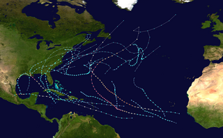
The 2010 Atlantic hurricane season was the first of three consecutive very active Atlantic hurricane seasons, each with 19 named storms. This above average activity included 12 hurricanes, equaling the number that formed in 1969. Only the 2020 and 2005 seasons have had more, at 14 and 15 hurricanes respectively. Despite the high number of hurricanes, not one hurricane hit the United States, making the season the only season with 10 or more hurricanes without a United States landfall. The overall tropical cyclone count in the Atlantic exceeded that in the West Pacific for only the second time on record. The season officially began on June 1 and ended on November 30, dates that conventionally delimit the period during each year when tropical cyclone formation is most likely. The first cyclone, Alex intensified into the first June hurricane since Allison in 1995. The month of September featured eight named storms. October featured five hurricanes, including Tomas, which became the latest on record in a calendar year to move through the Windward Islands. Activity was represented with an accumulated cyclone energy (ACE) value of 165 units, which was the eleventh highest value on record at the time. The activity in 2010 was heightened due to a very strong La Niña, which also led to an inactive Pacific hurricane season.
The 2000 Atlantic hurricane season was an event in the annual tropical cyclone season in the north Atlantic Ocean. There was above-normal activity during the season, with nearly all its activity occurring during a three-month period, August–October. The season officially began on June 1, 2000 and ended on November 30, 2000. These dates, adopted by convention, historically describe the period in each year when most tropical systems form. Although two tropical depressions formed in June, the first named storm, Alberto, did not arise until August 4. The season's final storm, an unnamed subtropical storm, became extratropical on October 29.

The 2014 Atlantic hurricane season was a well below-average hurricane season in terms of named storms while the number of hurricanes and major hurricanes, were overall average. It produced nine tropical cyclones, eight of which became named storms; six storms became hurricanes and two intensified further into major hurricanes. The season officially began on June 1, and ended on November 30. These dates historically describe the period each year when most tropical cyclones form in the Atlantic basin. The first storm of the season, Arthur, developed on July 1, while the final storm, Hanna, dissipated on October 28, about a month prior to the end of the season.

The 2019 Atlantic hurricane season was the fourth consecutive above-average and damaging season dating back to 2016. The season featured eighteen named storms, however, many storms were weak and short-lived, especially towards the end of the season. Six of those named storms achieved hurricane status, while three intensified into major hurricanes. Two storms became Category 5 hurricanes, marking the fourth consecutive season with at least one Category 5 hurricane, and the third consecutive season to feature at least one storm making landfall at Category 5 intensity. It was also the seventh season on record to have multiple tropical cyclones reaching Category 5 strength, which would not occur again until 2024. The season officially began on June 1 and ended on November 30. These dates historically describe the period each year when most tropical cyclones form in the Atlantic basin and are adopted by convention. However, tropical cyclogenesis is possible at any time of the year, as demonstrated by the formation of Subtropical Storm Andrea on May 20, making this the fifth consecutive year in which a tropical or subtropical cyclone developed outside of the official season.

The 2020 Atlantic hurricane season was the most active Atlantic hurricane season on record, in terms of the number of systems. It featured a total of 31 tropical and subtropical cyclones, with all but one cyclone becoming a named storm. Of the 30 named storms, 14 developed into hurricanes, and a record-tying seven further intensified into major hurricanes. It was the second and final season to use the Greek letter storm naming system, the first being 2005, the previous record. Of the 30 named storms, 11 of them made landfall in the contiguous United States, breaking the record of nine set in 1916. During the season, 27 tropical storms established a new record for earliest formation date by storm number. This season also featured a record ten tropical cyclones that underwent rapid intensification, tying it with 1995, as well as tying the record for most Category 4 hurricanes in a singular season in the Atlantic Basin. This unprecedented activity was fueled by a La Niña that developed in the summer months of 2020, continuing a stretch of above-average seasonal activity that began in 2016. Despite the record-high activity, this was the first season since 2015 in which no Category 5 hurricanes formed.
The 2021 Atlantic hurricane season was the third-most active Atlantic hurricane season on record in terms of number of tropical cyclones, although many of them were weak and short-lived. With 21 named storms forming, it became the second season in a row and third overall in which the designated 21-name list of storm names was exhausted. Seven of those storms strengthened into hurricanes, four of which reached major hurricane intensity, which is slightly above-average. The season officially began on June 1 and ended on November 30. These dates historically describe the period in each year when most Atlantic tropical cyclones form. However, subtropical or tropical cyclogenesis is possible at any time of the year, as demonstrated by the development of Tropical Storm Ana on May 22, making this the seventh consecutive year in which a storm developed outside of the official season.

The 2022 Atlantic hurricane season was a destructive and deadly Atlantic hurricane season. Despite having an average number of named storms and below average amount of major hurricanes, it became the fourth-costliest Atlantic hurricane season on record, behind only 2024, 2005, and 2017, mostly due to Hurricane Ian. The season officially began on June 1, and ended on November 30. These dates, adopted by convention, historically describe the period in each year when most subtropical or tropical cyclogenesis occurs in the Atlantic Ocean. This year's first Atlantic named storm, Tropical Storm Alex, developed four days after the start of the season, making this the first season since 2014 not to have a pre-season named storm.

Hurricane Marco was the first of two tropical cyclones to threaten the Gulf Coast of the United States within a three-day period. The thirteenth named storm and third hurricane of the record-breaking 2020 Atlantic hurricane season, Marco developed from a fast-moving tropical wave west of the Windward Islands and south of Jamaica on August 20. The fast motion of the wave inhibited intensification initially, but as the wave slowed down and entered a more favorable environment, the system developed into a tropical depression, which in turn rapidly intensified into a strong tropical storm. Due to strong wind shear, Marco's intensification temporarily halted. However, after entering the warm waters of the Gulf of Mexico on August 23, Marco briefly intensified into a hurricane, only to quickly weaken later that evening due to another rapid increase in wind shear. Marco subsequently weakened to a tropical depression before degenerating into a remnant low early the next morning. Marco's remnants subsequently dissipated on August 26.

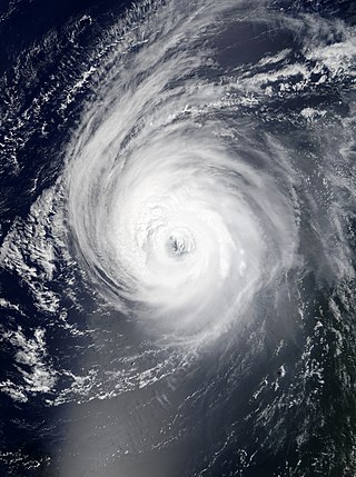
Hurricane Paulette was a strong and long-lived tropical cyclone which became the first to make landfall in Bermuda since Hurricane Gonzalo in 2014, and was the longest-lasting tropical cyclone of 2020 globally. The sixteenth named storm and sixth hurricane of the record-breaking 2020 Atlantic hurricane season, Paulette developed from a tropical wave that left the coast of Africa on September 2. The wave eventually consolidated into a tropical depression on September 7. Paulette fluctuated in intensity over the next few days, due to strong wind shear, initially peaking as a strong tropical storm on September 8. It eventually strengthened into a hurricane early on September 13 as shear decreased. On September 14, Paulette made landfall in northeastern Bermuda as a Category 2 hurricane, while making a gradual turn to the northeast. The cyclone further strengthened as it moved away from the island, reaching its peak intensity with 1-minute sustained winds of 105 mph (169 km/h) and a minimum central atmospheric pressure of 965 mbar (28.5 inHg) on September 14. On the evening of September 15, Paulette began to weaken and undergo extratropical transition, which it completed on September 16. The hurricane's extratropical remnants persisted and moved southward then eastward, and eventually, Paulette regenerated into a tropical storm early on September 20 south of the Azores– which resulted in the U.S National Weather Service coining the phrase "zombie storm" to describe its unusual regeneration. Paulette's second phase proved short-lived, however, as the storm quickly weakened and became post-tropical again two days later. The remnant persisted for several days before dissipating south of the Azores on September 28. In total, Paulette was a tropical cyclone for 11.25 days, and the system had an overall lifespan of 21 days.

Hurricane Epsilon was a strong tropical cyclone that affected Bermuda, and parts of North America and Western Europe. The twenty-seventh tropical or subtropical cyclone, twenty-sixth named storm, eleventh hurricane, and fourth major hurricane of the extremely-active 2020 Atlantic hurricane season, Epsilon had a non-tropical origin, developing from an upper-level low off the East Coast of the United States on October 13. The low gradually organized, becoming Tropical Depression Twenty-Seven on October 19, and six hours later, Tropical Storm Epsilon. The storm executed a counterclockwise loop before turning westward, while strengthening. On October 20, Epsilon began undergoing rapid intensification, becoming a Category 1 hurricane on the next day, before peaking as a Category 3 major hurricane on October 22, with maximum 1-minute sustained winds of 115 mph (185 km/h) and a minimum central pressure of 952 millibars (28.1 inHg). This made Epsilon the easternmost major hurricane this late in the calendar year, as well as the strongest late-season major hurricane in the northeastern Atlantic, and the fastest recorded case of a tropical cyclone undergoing rapid intensification that far northeast that late in the hurricane season. Afterward, Epsilon began to weaken as the system turned northward, with the storm dropping to Category 1 intensity late that day. Epsilon maintained its intensity as it moved northward, passing to the east of Bermuda. On October 24, Epsilon turned northeastward and gradually accelerated, before weakening into a tropical storm on the next day. On October 26, Epsilon transitioned into an extratropical cyclone, before being absorbed by another larger extratropical storm later that same day.
Hurricane Larry was a strong and long-lived tropical cyclone that became the first hurricane to make landfall in Newfoundland since Igor in 2010. The twelfth named storm, fifth hurricane, and third major hurricane of the 2021 Atlantic hurricane season, Larry originated from a tropical wave that emerged off the coast of Africa and organized into a tropical depression on August 31. The next day, the depression developed into a tropical storm, receiving the name Larry. The storm moved quickly across the far eastern tropical Atlantic, where it strengthened into a Category 1 hurricane the morning of September 2. Then, after undergoing a period of rapid intensification, Larry became a major Category 3 hurricane early on September 4. After churning for several days as a strong hurricane in the open ocean, Larry made landfall in Newfoundland on September 11, as a Category 1 hurricane. Later that day, Larry became an extratropical cyclone. Finally, on September 13, Larry was absorbed by a larger extratropical cyclone near Greenland.

Hurricane Earl was a large, long-lived Category 2 hurricane that brought heavy rain to Puerto Rico and Newfoundland in September 2022 despite remaining mostly out to sea. The fifth named storm and second hurricane of the 2022 Atlantic hurricane season, Earl originated from a tropical wave that moved off the coast of Africa on August 25. The wave struggled to develop over the next week as it moved west-northwestward in a marginally conducive environment. Eventually, the system was able to organize into Tropical Storm Earl on September 3. The storm passed through parts of the Caribbean, but strong wind shear initially halted Earl from intensifying and it maintained tropical storm status. The storm then turned northward into a more favorable environment and started to intensify. Earl eventually reached Category 2 hurricane status, before repeated dry air entrainments caused the storm to fluctuate in intensity. Earl reached peak winds of 110 mph (175 km/h) before quickly becoming extratropical off the coast of Newfoundland on September 10. It continued moving northeast before dissipating on September 15.

Hurricane Lee was a long-lived and intense tropical cyclone which impacted Bermuda, the Northeastern United States, and Eastern Canada in September 2023. The twelfth named storm, fourth hurricane, and third major hurricane of the 2023 Atlantic hurricane season, Lee formed on September 5 from a tropical wave that had moved offshore from West Africa into the tropical Atlantic a few days earlier. A strong steering current caused the storm to track northwestward, far from the Northern Leeward Islands. Highly favorable conditions enabled Lee to rapidly intensify to a Category 5 hurricane on September 7, its winds increased by 80 mph (130 km/h) in 24 hours. This makes it the fifth‑fastest rapid intensification on record in the Atlantic, only behind Hurricane Wilma in 2005, Hurricane Felix in 2007, Hurricane Milton in 2024, and Hurricane Matthew in 2016. Just as quickly however, Lee's strength waned, and it fluctuated in intensity for several days on account of strong wind shear and multiple eyewall replacement cycles.


