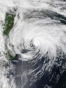
Meteorological history | |
---|---|
Formed | May 16,2020 |
Extratropical | May 19 |
Dissipated | May 21,2020 |
Tropical storm | |
1-minute sustained (SSHWS/NWS) | |
Highest winds | 60 mph (95 km/h) |
Lowest pressure | 990 mbar (hPa);29.23 inHg |
Overall effects | |
Fatalities | None |
Damage | $112,000 (2020 USD) |
Areas affected | Cuba,South Florida,The Bahamas,North Carolina,Mid-Atlantic United States,Bermuda |
Part of the 2020 Atlantic hurricane season |
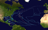
Tropical Storm Arthur was a strong off-season tropical cyclone that impacted the East Coast of the United States in May 2020. The first of thirty-one depressions and thirty different named storms of the extremely active 2020 Atlantic hurricane season,Arthur marked the record sixth consecutive year in the Atlantic basin with a tropical cyclone forming before June. It was one of two off-season storms in the season,alongside short-lived Tropical Storm Bertha. Arthur originated from a front that stalled over the Straits of Florida on May 10,which slowly drifted south for two days. The system became a tropical depression on May 16 north of The Bahamas. A day later,the system intensified into a tropical storm and was named Arthur. Arthur gradually intensified while tracking towards the Outer Banks of North Carolina,attaining its peak intensity with maximum 1-minute sustained winds of 60 mph (97 km/h) and a minimum central pressure of 990 mbar (29 inHg) on May 19,before skirting the region and becoming an extratropical cyclone. The cyclone then accelerated towards Bermuda and dissipated on May 21.
Arthur caused choppy seas and rip currents to much of the East Coast. In its formative stages,the storm brought severe weather,including hail and high winds,to southern Florida. In the state,heavy rain caused the ceiling of a house to collapse on a boy,injuring him. Tropical cyclone warnings and watches were issued for North Carolina,where Arthur brought heavy rain and tropical storm-force wind gusts to the coastline. Elsewhere,the storm caused gusty winds. No fatalities were reported from the storm,and according to the National Centers for Environmental Information,damage totaled $112,000 (2020 USD).
Arthur's origins can be traced to a front that stalled over the Straits of Florida on May 10. [1] On May 12, the National Hurricane Center (NHC) first discussed the possibility of subtropical development north of the Bahamas in relation with the front. [2] Scattered convection, or thunderstorms, began to increase in association with an upper-level trough that moved into the Gulf of Mexico on May 14. [1] [3] Over the next day, the low moved north-northeastward, steered around a subtropical ridge to its east, and passed just east of the southeastern Florida coast. The center was located over the warm waters of the Gulf Stream. [1] Convection began to slowly build around the center by early May 16, and Doppler weather radar showed a well-defined low-level circulation (LLC) had formed displaced just slightly east of the main thunderstorms. [1] [4] Based on this, the NHC upgraded the low to Tropical Depression One at 18:00 UTC on May 16 while located about 125 miles (201 km) east of Melbourne, Florida. [1] The system was considered tropical instead of subtropical in nature due to persisting central deep convection and a tight radius of maximum winds. [5]
Based on reports from a Hurricane Hunter aircraft of tropical-storm force winds, the NHC upgraded the system to Tropical Storm Arthur at 00:00 UTC on May 17. [6] Being steered generally north-northeast for the next several hours, Arthur stayed well offshore of the coasts of Florida and Georgia. [7] However, a mid-level trough centered over the United States caused Arthur to slowly be pushed northeastwards over a section of relatively cool waters and as a result most of the storm's convection became limited to the east of the circulation. [8] Despite a lopsided structure, reconnaissance aircraft found Arthur slightly stronger, despite its appearance on satellite. [9] Deep convection began to swiftly re-develop over the center as the storm began to move over warmer waters of the Gulf Stream, resulting in strengthening. [10] [11] Wind shear increased as Arthur neared North Carolina, which began separating the storm's convection from the LLC. The storm passed a mere 20 mi (32 km) southeast from Cape Hatteras early on May 18. [12] By that time, the storm was interacting with a frontal boundary, which triggered extratropical transition. [1] At 00:00 UTC on May 19, Arthur obtained its minimum central pressure of 990 mb (29 inHg) and its peak intensity of 60 mph (97 km/h). [1] Six hours later, the storm completed its transition to an extratropical cyclone as a trailing warm front developed behind the now almost fully exposed LLC. [13] The extratropical storm turned southeast on May 20 as the trough Arthur was interacting with passed the cyclone to the north. Arthur then tracked south towards Bermuda and dissipated early on May 21. [1]
The precursor to Arthur dropped heavy rainfall in Granma Province in Cuba on May 15, including 78 mm (3.1 in) of rainfall in Bayamo in only four hours. These rains resulted in indunated streets and flood damage to homes. [14] In the Bahamas, squalls occurred on Grand Bahama island, where many were still recovering from the adverse effects of Hurricane Dorian, which devastated the country in September 2019. [1] Gusty winds damaged tents and other temporary shelters across the island, and heavy rainfall caused some minimal flooding. [15] However, since the strongest winds of the disturbance were located to the east of the center, damage was limited. [16]
The extratropical remnants of Arthur brought gale-force winds to Bermuda. A sustained wind of 45 mph (72 km/h) was recorded at a weather observation site on Pearl Island, Bermuda. In addition, a gust of 63 mph (101 km/h) was recorded at the same spot. [1]
Arthur caused dangerous water conditions at beaches as it passed east of Florida. Rip currents led to the water rescues of 70 people in Volusia County, 3 of whom were hospitalized. [17] In addition, rainbands from the precursor disturbance to Arthur caused heavy rain and severe thunderstorms in South Florida. Over 4 in (100 mm) of rain fell in many sections of the Middle Keys and a peak rainfall total of 5.35 in (136 mm) fell in Marathon on May 14, where it was the tenth highest rainfall amount for the city on record and second most for May. [18] [19] Flash flood warnings were issued for large portions of Miami-Dade County on May 14, where street flooding was reported. [20] Tropical storm-force wind gusts as well as waterspouts prompted the issuance of gale warnings and special marine warnings across the majority of South Florida. [21] In St. Petersburg, a large tree was uprooted by strong winds from a squall line. [22] Lightning from Arthur's rainbands caused a house fire in North Naples. No one was injured, and estimated damage was at $50,000. [23] A trained weather spotter reported nickel-sized hail in Wellington. [24] In the same town, a storm chaser reported a funnel cloud. [25] Gale-force wind gusts were recorded in Coconut Grove, causing a large tree to fall onto a house. [26] In Hollywood, heavy rain caused a ceiling to collapse on a 5-year-old boy and another family member. The boy was struck on the head by debris and took to the hospital. [27] In Davie, a patio roof collapsed, destroying furniture. In the same town, a man was in critical condition after being electrocuted while fixing an electronic appliance in the rain. [28] Damage across Florida reached $112,000. [29]
On May 16, tropical storm watches were issued from Surf City to Duck and Pamlico Sound to Albemarle Sound. [30] A day later, these watches were upgraded to tropical storm warnings as Arthur moved closer towards the Outer Banks. [31] In anticipation of inclement weather conditions associated with Tropical Storm Arthur, Dare County Public Works suspended residential and commercial trash collection in Colington Island, Kitty Hawk, Buxton, Frisco, and Hatteras. Commercial collection was also suspended for Manteo, Wanchese, Manns Harbor, Stumpy Point, Rodanthe, Waves, Salvo, and Avon. [32] By late May 17, rough surf conditions were already being experienced on the southern portion of the Outer Banks. [33] Torrential rainfall occurred as Arthur's outer rainbands scraped eastern North Carolina, [34] with 4.92 in (125 mm) of rain falling in Newport within 6 hours, and many other locations recording at least 3 in (76 mm) of rain from the storm. [35] Tropical storm-force wind gusts in Cape Hatteras were also recorded, although the lopsided nature of the storm kept the strongest winds offshore. [36] [34] The only tropical-storm force 1-minute sustained winds was at Alligator River Bridge in Tyrrell County. [1] Wave heights as high as 12.5 ft (3.8 m) were recorded from buoys along the coast of the Outer Banks from Arthur. [37] Due to flooding from Arthur, many highways in the Outer Banks and into mainland North Carolina were closed. [33] SpaceX was also forced to delay the launch of several Starlink internet satellites due to adverse weather from Arthur affecting the recovery fleet. [38] As Arthur moved away from the coast, tropical storm warnings were lifted as conditions gradually improved later in the evening. [39]
Purple and red flags were raised along the coasts of Georgia and South Carolina to alert the public for rip currents. [40] Offshore Georgia, 3–6 ft (0.91–1.83 m) waves were reported. [41] In James City County, Virginia, moderate coastal flooding was reported in some places. [42] In southern New Jersey, Post-Tropical Cyclone Arthur, along with a large upper-level low to its west, caused coastal flooding and strong winds in towns on the Jersey Shore. Power lines were reported down in several towns. Trees were blown down on the Atlantic City Expressway and on U.S. Route 30 in Mullica Township. [43]
The 2002 Atlantic hurricane season was a near-average Atlantic hurricane season. It officially started on June 1, 2002, and ended on November 30, dates which conventionally limit the period of each year when most tropical cyclones develop in the Atlantic Ocean. The season produced fourteen tropical cyclones, of which twelve developed into named storms; four became hurricanes, and two attained major hurricane status. While the season's first cyclone did not develop until July 14, activity quickly picked up: eight storms developed in the month of September. It ended early however, with no tropical storms forming after October 6—a rare occurrence caused partly by El Niño conditions. The most intense hurricane of the season was Hurricane Isidore with a minimum central pressure of 934 mbar, although Hurricane Lili attained higher winds and peaked at Category 4 whereas Isidore only reached Category 3. However, Lili had a minimum central pressure of 938 mbar.
The 2008 Atlantic hurricane season was the most destructive Atlantic hurricane season since 2005, causing over 1,000 deaths and nearly $50 billion in damage. The season ranked as the third costliest ever at the time, but has since fallen to ninth costliest. It was an above-average season, featuring sixteen named storms, eight of which became hurricanes, and five which further became major hurricanes. It officially started on June 1 and ended on November 30. These dates conventionally delimit the period of each year when most tropical cyclones form in the Atlantic basin. However, the formation of Tropical Storm Arthur caused the season to start one day early. It was the only year on record in which a major hurricane existed in every month from July through November in the North Atlantic. Bertha became the longest-lived July tropical cyclone on record for the basin, the first of several long-lived systems during 2008.
Tropical Storm Alberto was the first tropical storm of the 2006 Atlantic hurricane season. Forming on June 10 in the northwestern Caribbean, the storm moved generally to the north, reaching a maximum intensity of 70 mph (110 km/h) before weakening and moving ashore in the Big Bend area of Florida on June 13. Alberto then moved through eastern Georgia, North Carolina, and Virginia as a tropical depression before becoming extratropical on June 14.
Tropical Storm Helene was a long-lived tropical cyclone that oscillated for ten days between a tropical wave and a 70 mph (110 km/h) tropical storm. It was the twelfth tropical cyclone and eighth tropical storm of the 2000 Atlantic hurricane season, forming on September 15 east of the Windward Islands. After degenerating into a tropical wave, the system produced flooding and mudslides in Puerto Rico. It reformed into a tropical depression on September 19 south of Cuba, and crossed the western portion of the island the next day while on the verge of dissipation. However, it intensified into a tropical storm in the Gulf of Mexico, reaching its peak intensity while approaching the northern Gulf Coast.
Hurricane Kyle was the fifth-longest-lived Atlantic tropical or subtropical cyclone on record. The eleventh named storm and third hurricane of the 2002 Atlantic hurricane season, Kyle developed as a subtropical cyclone on September 20 to the east-southeast of Bermuda. Looping westward, it transitioned into a tropical cyclone and became a hurricane on September 25. For the next two weeks, Kyle tracked generally westward, oscillating in strength several times because of fluctuations in environmental conditions. On October 11, the cyclone turned northeastward and made landfalls near Charleston, South Carolina, and Long Beach, North Carolina, at tropical storm status. After lasting as a cyclone for 22 days, Kyle dissipated on October 12 as it was absorbed by an approaching cold front.
Tropical Storm Edouard was the first of eight named storms to form in September 2002, the most such storms in the North Atlantic for any month at the time. The fifth tropical storm of the 2002 Atlantic hurricane season, Edouard developed into a tropical cyclone on September 1 from an area of atmospheric convection associated with a cold front east of Florida. Under weak steering currents, Edouard drifted to the north and executed a clockwise loop to the west. Despite moderate to strong levels of wind shear, the storm reached a peak intensity of 65 mph (105 km/h) on September 3, but quickly weakened as it tracked westward. Edouard made landfall on northeastern Florida on September 5, and after crossing the state it dissipated on September 6 while becoming absorbed into the larger circulation of Tropical Storm Fay.
Tropical Storm Barry was a rapidly forming tropical cyclone that made landfall on Florida, United States, in early June 2007. The second named storm of the 2007 Atlantic hurricane season, Barry developed from a trough of low pressure in the southeastern Gulf of Mexico on June 1. It tracked rapidly northeastward, reaching peak winds of 60 mph (97 km/h) before weakening and making landfall near Tampa Bay as a tropical depression. Barry quickly lost tropical characteristics after wind shear removed much of the convection, and early on June 3, it completed the transition into an extratropical cyclone. The extratropical remnants tracked up the East Coast of the United States, and were absorbed by a larger extratropical cyclone on June 5.
Tropical Storm Cristobal was a strong tropical storm that paralleled the East Coast of the United States, traveling from Florida to Nova Scotia. The third named storm of the 2008 Atlantic hurricane season, Cristobal formed on July 19 from a trough of low pressure off the Southeast U.S. Coast. In a marginally favorable environment, it attained minimal tropical storm status later that day. The storm remained offshore, and peaked as a strong tropical storm on July 21 while it passed east of Cape Hatteras. It accelerated northeast parallel to the East Coast and became extratropical on July 23 near Nova Scotia. Because it was a weak storm and never made landfall, Cristobal's effects were mostly limited to moderate rainfall. The storm dropped 3.43 in (87 mm) of rain in Wilmington, North Carolina, where minor flooding was reported. Additionally, the extratropical remnants contributed to rainfall on Nova Scotia which caused some street and basement flooding.
Tropical Storm Beryl was the strongest off-season Atlantic tropical cyclone on record to make landfall in the United States. The second tropical cyclone of the 2012 Atlantic hurricane season, Beryl developed on May 26 from a low-pressure system offshore North Carolina. Initially subtropical, the storm slowly acquired tropical characteristics as it tracked across warmer sea surface temperatures and within an environment of decreasing vertical wind shear. Late on May 27, Beryl transitioned into a tropical cyclone less than 120 miles (190 km) from North Florida. Early the following day, the storm moved ashore near Jacksonville Beach, Florida, with peak winds of 65 mph (100 km/h). It quickly weakened to a tropical depression, dropping heavy rainfall while moving slowly across the southeastern United States. A cold front turned Beryl to the northeast, and the storm became extratropical on May 30.
The 2016 Atlantic hurricane season was the deadliest Atlantic hurricane season since 2008, and the first above-average hurricane season since 2012, producing 15 named storms, 7 hurricanes and 4 major hurricanes. The season officially started on June 1 and ended on November 30, though the first storm, Hurricane Alex which formed in the Northeastern Atlantic, developed on January 12, being the first hurricane to develop in January since 1938. The final storm, Otto, crossed into the Eastern Pacific on November 25, a few days before the official end. Following Alex, Tropical Storm Bonnie brought flooding to South Carolina and portions of North Carolina. Tropical Storm Colin in early June brought minor flooding and wind damage to parts of the Southeastern United States, especially Florida. Hurricane Earl left 94 fatalities in the Dominican Republic and Mexico, 81 of which occurred in the latter. In early September, Hurricane Hermine, the first hurricane to make landfall in Florida since Hurricane Wilma in 2005, brought extensive coastal flooding damage especially to the Forgotten and Nature coasts of Florida. Hermine was responsible for five fatalities and about $550 million (2016 USD) in damage.
The 2019 Atlantic hurricane season was the fourth consecutive above-average and damaging season dating back to 2016. However, many were weak and short-lived, especially towards the end of the season. Six of those named storms achieved hurricane status, while three intensified into major hurricanes. Two storms became Category 5 hurricanes, marking the fourth consecutive season with at least one Category 5 hurricane, the third consecutive season to feature at least one storm making landfall at Category 5 intensity, and the seventh on record to have multiple tropical cyclones reaching Category 5 strength. The season officially began on June 1 and ended on November 30. These dates historically describe the period each year when most tropical cyclones form in the Atlantic basin and are adopted by convention. However, tropical cyclogenesis is possible at any time of the year, as demonstrated by the formation of Subtropical Storm Andrea on May 20, making this the fifth consecutive year in which a tropical or subtropical cyclone developed outside of the official season.
The 2020 Atlantic hurricane season was the most active Atlantic hurricane season on record, in terms of number of systems. It featured a total of 31 tropical or subtropical cyclones, with all but one cyclone becoming a named storm. Of the 30 named storms, 14 developed into hurricanes, and a record-tying seven further intensified into major hurricanes. It was the second and final season to use the Greek letter storm naming system, the first being 2005, the previous record. Of the 30 named storms, 11 of them made landfall in the contiguous United States, breaking the record of nine set in 1916. During the season, 27 tropical storms established a new record for earliest formation date by storm number. This season also featured a record 10 tropical cyclones that underwent rapid intensification, tying it with 1995, as well as tying the record for most Category 4 hurricanes in a singular season in the Atlantic Basin. This unprecedented activity was fueled by a La Niña that developed in the summer months of 2020 as it did, continue a stretch of above-average seasonal activity that began in 2016. Despite the record-high activity, this was the first season since 2015 in which no Category 5 hurricane formed.
Tropical Storm Bonnie was a weak but persistent tropical cyclone that brought heavy rains to the Southeastern United States in May 2016. The second storm of the season, Bonnie formed from an area of low pressure northeast of the Bahamas on May 27, a few days before the official hurricane season began on June 1. Moving steadily west-northwestwards, Bonnie intensified into a tropical storm on May 28 and attained peak winds six hours later. However, due to hostile environmental conditions, Bonnie weakened to a depression hours before making landfall just east of Charleston, South Carolina, on May 29. Steering currents collapsed afterwards, causing the storm to meander over South Carolina for two days. The storm weakened further into a post-tropical cyclone on May 31, before emerging off the coast while moving generally east-northeastwards. On June 2, Bonnie regenerated into a tropical depression just offshore North Carolina as conditions became slightly more favorable. The next day, despite increasing wind shear and cooling sea surface temperatures, Bonnie reintensified into a tropical storm and reached its peak intensity. The storm hung on to tropical storm strength for another day, before weakening into a depression late on June 4 and became post-tropical early the next day.
Tropical Storm Julia was a weak tropical cyclone that caused minor damage across the Eastern United States in September 2016. The tenth named storm of the 2016 Atlantic hurricane season, Julia developed from a tropical wave near the coast of east-central Florida on September 13. Initially a tropical depression, the system soon made landfall near Jensen Beach. Despite moving inland, the cyclone intensified into a tropical storm, shortly before strengthening further to reach maximum sustained winds of 50 mph (85 km/h). Julia then drifted north-northwestward and then northeastward, moving offshore the Southeastern United States on September 14. A cyclonic loop occurred as strong westerly air developed in the region, with the shear causing fluctuations in intensity. By September 19, Julia degenerated into a remnant low, which later transitioned into an extratropical cyclone and moved inland over North Carolina before dissipating on September 21.
Tropical Storm Cindy was an Atlantic hurricane which became the first tropical cyclone to make landfall in Louisiana since Hurricane Isaac in 2012. The third named storm of the extremely active 2017 Atlantic hurricane season, Cindy formed out of a broad area of low pressure that developed in the northwestern Caribbean Sea near the Yucatán Peninsula in mid-June 2017. The disturbance gradually organized as it drifted northwards into the Gulf of Mexico, and was first designated as a potential tropical cyclone by the National Hurricane Center on June 19, before organizing into a tropical storm the next day. While slowly moving to the northwest, Cindy's intensification was slow due to the effects of dry air and moderate to strong wind shear. After peaking with sustained winds of 60 mph (95 km/h) on June 21, Cindy weakened slightly prior to making landfall in southwestern Louisiana on June 22. The storm quickly weakened after moving inland and degenerated into a remnant low on June 23, dissipating over the Mid-Atlantic on the following day.
Hurricane Harvey was the costliest tropical cyclone on record, inflicting roughly $125 billion in damage across the Houston metropolitan area and Southeast Texas. It lasted from mid-August until early September 2017, with many records for rainfall and landfall intensity set during that time. The eighth named storm, third hurricane, and first major hurricane of the 2017 Atlantic hurricane season, Harvey originated from a broad area of low pressure southwest of Cape Verde that was first monitored on August 13. Tracking steadily westward, the disturbance developed strong convection, a well-defined circulation, and sustained tropical storm-force winds, leading to the classification of Tropical Storm Harvey late on August 17. Moderate easterly vertical wind shear kept Harvey weak, as it continued westwards into the Caribbean Sea; despite repeated predictions for gradual intensification by the National Hurricane Center, Harvey eventually opened up into a tropical wave on August 19. The remnants of Harvey continued to move westwards and reached the Yucatán Peninsula on August 22, and were forecast to regenerate into a tropical cyclone after exiting land.
Potential Tropical Cyclone Ten was a damaging storm that was the tenth tropical disturbance designated by the National Hurricane Center (NHC) during the 2017 Atlantic hurricane season. The disturbance was deemed to have a very high chance of becoming a tropical cyclone while posing a threat to populated areas and was designated a "Potential Tropical Cyclone". The storm caused flooding and brought tropical storm-force winds to parts of the Southeastern United States and the Mid-Atlantic states, particularly Florida and the Carolinas, before going on to affect parts of Atlantic Canada. Potential Tropical Cyclone Ten was the tenth storm that had advisories issued on it by the NHC in 2017, and the only such system that failed to fully develop into a tropical cyclone during that Atlantic hurricane season. Potential Tropical Cyclone Ten originated from a tropical wave that moved off the coast of West Africa on August 13. The disturbance slowly tracked its way westward across the Atlantic Ocean, before reaching Florida in late August. The disturbance came close to developing into a tropical storm while it was situated off the coast of the Carolinas; however, strong wind shear and outflow from Hurricane Harvey prevented the storm from organizing into a tropical cyclone. The system transitioned into an extratropical cyclone instead, and became a strong hurricane-force low to the south of Newfoundland, before being absorbed by another extratropical system near Iceland on September 3.
Tropical Storm Fay was the first tropical cyclone to make landfall in the U.S state of New Jersey since Hurricane Irene in 2011. The sixth named storm of the very active 2020 Atlantic hurricane season, Fay was the earliest sixth named storm on record in the basin when it formed on July 9. Fay originated from a surface low that formed over the Northern Gulf of Mexico on July 3 and slowly drifted eastward, before crossing over the Florida Panhandle. The system subsequently drifted across the Southeastern United States as a well-defined low pressure system, before emerging off the coast of North Carolina on July 8. From there, the storm utilized favorable conditions for development, or tropical cyclogenesis, and coalesced into a tropical storm on July 9. The storm intensified, reaching its peak intensity on July 10, with maximum 1-minute sustained winds of 60 mph (97 km/h) and a minimum central pressure of 998 millibars (29.5 inHg). While moving northward, Fay made landfall on New Jersey later that day. After making landfall, the storm quickly lost most of its organization and rapidly transitioned into a post-tropical cyclone over New York on July 11, before being absorbed by a larger extratropical low over Quebec on July 12.