Accumulated cyclone energy

Last updated

Accumulated cyclone energy (ACE) is a metric used to compare overall activity of tropical cyclones, utilizing the available records of windspeeds at six-hour intervals to synthesize storm duration and strength into a single index value. [1] The ACE index may refer to a single storm or to groups of storms such as those within a particular month, a full season or combined seasons. [2] It is calculated by summing the square of tropical cyclones' maximum sustained winds, as recorded every six hours, but only for windspeeds of at least tropical storm strength (≥ 34 kn; 63 km/h; 39 mph); [3] the resulting figure is divided by 10,000 to place it on a more manageable scale. [1]

Contents

The calculation originated as the Hurricane Destruction Potential (HDP) index, which sums the squares of tropical cyclones' maximum sustained winds while at hurricane strength, at least 64 knots (≥ 119 km/h; 74 mph) [3] at six-hour recorded intervals across an entire season. [4] The HDP index was later modified to further include tropical storms, that is, all wind speeds of at least 34 knots (≥ 63 km/h; 39 mph), [3] to become the accumulated cyclone energy index. [5]

The highest ACE calculated for a single tropical cyclone on record worldwide is 87.01, set by Cyclone Freddy in 2023. [6]

History

The accumulated cyclone energy index is an offshoot of Hurricane Destruction Potential (HDP), an index created in 1988 by William Gray and his associates at Colorado State University [4] who argued the destructiveness of a hurricane's wind and storm surge is better related to the square of the maximum wind speed () than simply to the maximum wind speed (). [4] The HDP index is calculated by squaring the estimated maximum sustained wind speeds for tropical cyclones while at hurricane strength, that is, wind speeds of at least 64 knots (≥ 119 km/h; 74 mph). [3] The squared windspeeds from six-hourly recorded intervals are then summed across an entire season. [5] [4] This scale was subsequently modified in 1999 by the United States National Oceanic and Atmospheric Administration (NOAA) to include not only hurricanes but also tropical storms, that is, all cyclones while windspeeds are at least 34 knots (≥ 63 km/h; 39 mph). [3] NOAA named the newly modified index accumulated cyclone energy. [5] Since the calculation was more broadly adjusted by NOAA, the index has been used in a number of different ways such as to compare individual storms, and by various agencies and researchers including the Australian Bureau of Meteorology and the India Meteorological Department. [7] [8] The purposes of the ACE index include to categorize how active tropical cyclone seasons were as well as to identify possible long-term trends in a certain area such as the Lesser Antilles. [9]

Calculation

Accumulated cyclone energy is calculated by summing the squares of the estimated maximum sustained velocity of tropical cyclones when wind speeds are at least tropical storm strength (≥ 34 kn; 63 km/h; 39 mph) [3] at recorded six-hour intervals. The sums are usually divided by 10,000 to make them more manageable. One unit of ACE equals 10−4  kn 2, and for use as an index the unit is assumed. Thus:

(for ≥ 34 kn),

where is estimated sustained wind speed in knots at six-hour intervals. [5]

Kinetic energy is proportional to the square of velocity. However, unlike the measure defined above, kinetic energy is also proportional to the mass (corresponding to the size of the storm) and represents an integral of force equal to mass times acceleration, , where acceleration is the antiderivative of velocity, or . The integral is a difference at the limits of the square antiderivative, rather than a sum of squares at regular intervals. Thus, the term applied to the index, accumulated cyclone energy, is a misnomer since the index is neither a measure of kinetic energy nor "accumulated energy."

Atlantic Ocean

Accumulated cyclone energy of North Atlantic hurricanes. Accumulated Cyclone Energy of North Atlantic hurricanes, OWID.svg
Accumulated cyclone energy of North Atlantic hurricanes.

Within the Atlantic Ocean, the United States National Oceanic and Atmospheric Administration and others use the ACE index of a season to classify the season into one of four categories. [9] These four categories are extremely active, above-normal, near-normal, and below-normal, and are worked out using an approximate quartile partitioning of seasons based on the ACE index over the 70 years between 1951 and 2020. [9] The median value of the ACE index from 1951 to 2020 is 96.7 x 10⁴ kt2. [9]

Classification criteria
CategoryACE Index % of 1951–2020
median
Extremely active> 159.6> 165%
Above-normal> 126.1> 130%
Near-normal73–126.175–130%
Below-normal< 73< 75%
Reference: [9]
Top 10 Atlantic hurricane seasons
Season TS HU MH ACE
1933 20116258.57
2005 28157245.3
1893 12105231.15
1926 1186229.56
1995 19115227.10
2004 1596226.88
2017 17106224.88
1950 16116211.28
1961 1285188.9
1998 14103181.76

Individual storms in the Atlantic

The highest ever ACE estimated for a single storm in the Atlantic is 73.6, for the San Ciriaco hurricane in 1899. A Category 4 hurricane which lasted for four weeks, this single storm had an ACE higher than many whole Atlantic storm seasons. Other Atlantic storms with high ACEs include Hurricane Ivan in 2004, with an ACE of 70.4, Hurricane Irma in 2017, with an ACE of 64.9, the Great Charleston Hurricane in 1893, with an ACE of 63.5, Hurricane Isabel in 2003, with an ACE of 63.3, and the 1932 Cuba hurricane, with an ACE of 59.8. [11]

Since 1950, the highest ACE of a tropical storm was Tropical Storm Philippe in 2023, which attained an ACE of 9.4. [12] The highest ACE of a Category 1 hurricane was Hurricane Nadine in 2012, which attained an ACE of 26.3. The record for lowest ACE of a tropical storm is jointly held by Tropical Storm Chris in 2000 and Tropical Storm Philippe in 2017, both of which were tropical storms for only six hours and had an ACE of just 0.1225. The lowest ACE of any hurricane was 2005's Hurricane Cindy, which was only a hurricane for six hours, and 2007's Hurricane Lorenzo, which was a hurricane for twelve hours; Cindy had an ACE of just 1.5175 and Lorenzo had a lower ACE of only 1.475. The lowest ACE of a major hurricane (Category 3 or higher), was Hurricane Gerda in 1969, with an ACE of 5.3. [13] The following table shows those storms in the Atlantic basin from 1851–2021 that have attained over 50 points of ACE. [13]

StormYear Peak classification ACEDuration
Hurricane Three 1899
Category 4 hurricane
73.628 days
Hurricane Ivan 2004
Category 5 hurricane
70.423 days
Hurricane Irma 2017
Category 5 hurricane
64.913 days
Hurricane Nine 1893
Category 3 hurricane
63.520 days
Hurricane Isabel 2003
Category 5 hurricane
63.314 days
Hurricane Fourteen 1932
Category 5 hurricane
59.815 days
Hurricane Donna 1960
Category 4 hurricane
57.616 days
Hurricane Carrie 1957
Category 4 hurricane
55.821 days
Hurricane Inez 1966
Category 5 hurricane
54.621 days
Hurricane Sam 2021
Category 4 hurricane
53.814 days
Hurricane Luis 1995
Category 4 hurricane
53.715 days
Hurricane Allen 1980
Category 5 hurricane
52.312 days
Hurricane Esther 1961
Category 5 hurricane
52.218 days
Hurricane Matthew 2016
Category 5 hurricane
50.912 days

Historical ACE in recorded Atlantic hurricane history

50
100
150
200
250
300
1950
1960
1970
1980
1990
2000
2010
2020

There is an undercount bias of tropical storms, hurricanes, and major hurricanes before the satellite era (prior to the mid–1960s), due to the difficulty in identifying storms.

Classification criteria

  Extremely active
  Above-normal
  Near-normal
  Below-normal
Accumulated Cyclone Energy - Atlantic
SeasonACE TS HU MH Classification
1851 36.24631Below normal
1852 73.28551Near normal
1853 76.49842Near normal
1854 31.00531Below normal
1855 18.12541Below normal
1856 48.94642Below normal
1857 46.84430Below normal
1858 44.79660Below normal
1859 55.73871Below normal
1860 62.06761Below normal
1861 49.71860Below normal
1862 46.03630Below normal
1863 50.35950Below normal
1864 26.55530Below normal
1865 49.13730Below normal
1866 83.65761Near normal
1867 59.97971Below normal
1868 34.65430Below normal
1869 51.021071Below normal
1870 87.811102Near normal
1871 88.39862Near normal
1872 65.38540Below normal
1873 69.47532Below normal
1874 47.05740Below normal
1875 72.48651Below normal
1876 56.05542Below normal
1877 73.36831Near normal
1878 180.8512102Extremely active
1879 63.63862Below normal
1880 131.081192Above normal
1881 59.25740Below normal
1882 59.4675642Below normal
1883 66.7432Below normal
1884 72.06441Below normal
1885 58.3860Below normal
1886 166.16512104Extremely active
1887 181.2619112Extremely active
1888 84.945962Near normal
1889 104.0425960Near normal
1890 33.345421Below normal
1891 116.1051071Near normal
1892 115.8375950Near normal
1893 231.147512105Extremely active
1894 135.42754Above normal
1895 68.765620Below normal
1896 136.0825762Above normal
1897 54.54630Below normal
1898 113.23751151Near normal
1899 151.0251052Above normal
1900 83.345732Near normal
1901 98.9751360Near normal
1902 32.65530Below normal
1903 102.071071Near normal
1904 30.345640Below normal
1905 28.3775511Below normal
1906 162.881163Extremely active
1907 13.06500Below normal
1908 95.111061Near normal
1909 93.341264Near normal
1910 63.9531Below normal
1911 34.2875630Below normal
1912 57.2625741Below normal
1913 35.595640Below normal
1914 2.53100Below normal
1915 130.095653Above normal
1916 144.012515105Above normal
1917 60.6675422Below normal
1918 39.8725641Below normal
1919 55.04521Below normal
1920 29.81540Below normal
1921 86.53752Near normal
1922 54.515531Below normal
1923 49.31941Below normal
1924 100.18751152Near normal
1925 7.2525410Below normal
1926 229.55751186Extremely active
1927 56.4775841Below normal
1928 83.475641Near normal
1929 48.0675531Below normal
1930 49.7725322Below normal
1931 47.8351331Below normal
1932 169.66251564Extremely active
1933 258.5720116Extremely active
1934 79.06751371Near normal
1935 106.2125853Near normal
1936 99.7751771Near normal
1937 65.851141Below normal
1938 77.575942Near normal
1939 43.6825631Below normal
1940 67.79960Below normal
1941 51.765643Below normal
1942 62.4851141Below normal
1943 94.011052Near normal
1944 104.45251483Near normal
1945 63.4151152Below normal
1946 19.6125730Below normal
1947 88.491052Near normal
1948 94.97751064Near normal
1949 96.44751672Near normal
1950 211.282516116Extremely active
1951 126.3251283Above normal
1952 69.081152Below normal
1953 98.50751473Near normal
1954 110.881673Near normal
1955 158.171394Above normal
1956 56.67251241Below normal
1957 78.6625832Near normal
1958 109.69251273Near normal
1959 77.10751472Near normal
1960 72.9842Below normal
1961 188.91285Extremely active
1962 35.5675740Below normal
1963 117.93251073Near normal
1964 1531375Above normal
1965 84.331041Near normal
1966 145.21751573Above normal
1967 121.7051361Near normal
1968 45.0725950Below normal
1969 165.737518123Extremely active
1970 40.181472Below normal
1971 96.52751361Near normal
1972 35.605730Below normal
1973 47.85841Below normal
1974 68.1251142Below normal
1975 76.0625963Near normal
1976 84.17251062Near normal
1977 25.3175651Below normal
1978 63.21751252Below normal
1979 92.9175962Near normal
1980 148.93751192Above normal
1981 100.32751273Near normal
1982 31.5025621Below normal
1983 17.4025431Below normal
1984 84.2951351Near normal
1985 87.98251173Near normal
1986 35.7925640Below normal
1987 34.36731Below normal
1988 102.99251253Near normal
1989 135.1251172Above normal
1990 96.80251481Near normal
1991 35.5375842Below normal
1992 76.2225741Near normal
1993 38.665841Below normal
1994 32.02730Below normal
1995 227.102519115Extremely active
1996 166.18251396Extremely active
1997 40.9275831Below normal
1998 181.767514103Extremely active
1999 176.52751285Extremely active
2000 119.14251583Near normal
2001 110.321594Near normal
2002 67.99251242Below normal
2003 176.841673Extremely active
2004 226.881596Extremely active
2005 245.328157Extremely active
2006 78.5351052Near normal
2007 73.8851562Near normal
2008 145.71751685Above normal
2009 52.58932Below normal
2010 165.482519125Extremely active
2011 126.30251974Above normal
2012 132.632519102Above normal
2013 36.121420Below normal
2014 66.725862Below normal
2015 62.6851142Below normal
2016 141.25251574Above normal
2017 224.877517106Extremely active
2018 132.58251582Above normal
2019 132.20251863Above normal
2020 180.372530147Extremely active
2021 145.55752174Above normal
2022 94.42251482Near normal
2023 145.55652073Above normal
2024 TBDTBDTBDTBDUpcoming season

Eastern Pacific

Most intense Pacific
hurricane seasons [14]
RankSeason ACE value
1 2018 318.1
2 1992 294.3
3 2015 290.2
4 1990 249.5
5 1978 207.7
6 1983 206.2
7 2014 202.4
8 1993 201.8
9 1984 193.7
10 1985 193.1

Within the Eastern Pacific Ocean, the United States National Oceanic and Atmospheric Administration and others use the ACE index of a season to classify the season into one of three categories. [15] These three categories are above-, near-, and below-normal and are worked out using an approximate tercile partitioning of seasons based on the ACE index and the number of tropical storms, hurricanes, and major hurricanes over the 30 years between 1991 and 2020. [15]

For a season to be defined as above-normal, the ACE index criterion and two or more of the other criteria given in the table below must be satisfied. [15]

The mean value of the ACE index from 1991 to 2020 is 108.7 x 10⁴ kt2, while the median value is 97.2 x 10⁴ kt2. [15]

Classification criteria
CategoryACE Index % of 1991–2020
median
Tropical
storms
HurricanesMajor
hurricanes
Above-normal> 115> 120%17 or more9 or more5 or more
Near normal80–11580–120%16 or fewer8 or fewer4 or fewer
Below-normal< 80< 80%
Reference: [15]

Individual storms in the Pacific

The highest ever ACE estimated for a single storm in the Eastern or Central Pacific, while located east of the International Date Line is 62.8, for Hurricane Fico of 1978. Other Eastern Pacific storms with high ACEs include Hurricane John in 1994, with an ACE of 54.0, Hurricane Kevin in 1991, with an ACE of 52.1, and Hurricane Hector of 2018, with an ACE of 50.5. [16]

The following table shows those storms in the Eastern and Central Pacific basins from 1971 through 2023 that have attained over 30 points of ACE. [17]

StormYear Peak classification ACEDuration
Hurricane Fico 1978
Category 4 hurricane
62.820 days
Hurricane John 1994
Category 5 hurricane
54.019 days
Hurricane Kevin 1991
Category 4 hurricane
52.117 days
Hurricane Hector 2018
Category 4 hurricane
50.513 days
Hurricane Dora 2023
Category 4 hurricane
48.412 days
Hurricane Tina 1992
Category 4 hurricane
47.722 days
Hurricane Trudy 1990
Category 4 hurricane
45.816 days
Hurricane Lane 2018
Category 5 hurricane
44.213 days
Hurricane Dora 1999
Category 4 hurricane
41.413 days
Hurricane Jimena 2015
Category 4 hurricane
40.015 days
Hurricane Guillermo 1997
Category 5 hurricane
40.016 days
Hurricane Norbert 1984
Category 4 hurricane
39.612 days
Hurricane Norman 2018
Category 4 hurricane
36.612 days
Hurricane Celeste 1972
Category 4 hurricane
36.316 days
Hurricane Sergio 2018
Category 4 hurricane
35.513 days
Hurricane Lester 2016
Category 4 hurricane
35.414 days
Hurricane Olaf 2015
Category 4 hurricane
34.612 days
Hurricane Jimena 1991
Category 4 hurricane
34.512 days
Hurricane Doreen 1973
Category 4 hurricane
34.316 days
Hurricane Ioke 2006
Category 5 hurricane
34.27 days
Hurricane Marie 1990
Category 4 hurricane
33.114 days
Hurricane Orlene 1992
Category 4 hurricane
32.412 days
Hurricane Greg 1993
Category 4 hurricane
32.313 days
Hurricane Hilary 2011
Category 4 hurricane
31.29 days

Indicates that the storm formed in the Eastern/Central Pacific, but crossed 180°W at least once; therefore, only the ACE and number of days spent in the Eastern/Central Pacific are included.

Historical ACE in recorded Pacific hurricane history

100
200
300
400
1971
1980
1990
2000
2010
2020
PDO.svg
Observed monthly values for the PDO index, 1900–present.
Hist east pac ace trend 1981-2015.gif
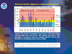
Historical East Pacific Seasonal Activity, 1981–2015.

Data on ACE is considered reliable starting with the 1971 season.

Classification criteria

  Above-normal
  Near-normal
  Below-normal
Accumulated Cyclone Energy - Pacific
SeasonACE TS HU MH Classification
1971 13918126Above normal
1972 1361484Near normal
1973 1141273Near normal
1974 9018113Near normal
1975 1121794Near normal
1976 1211595Above normal
1977 22840Below normal
1978 20719147Above normal
1979 571064Below normal
1980 771473Below normal
1981 721581Below normal
1982 16123125Above normal
1983 20621128Above normal
1984 19321137Above normal
1985 19224138Above normal
1986 1071793Near normal
1987 13220104Above normal
1988 1271573Near normal
1989 1101794Near normal
1990 24521166Above normal
1991 17814105Above normal
1992 295271610Above normal
1993 20115119Above normal
1994 18520105Above normal
1995 1001073Near normal
1996 53952Below normal
1997 1671997Above normal
1998 1341396Above normal
1999 90962Near normal
2000 951962Near normal
2001 901582Near normal
2002 1251686Near normal
2003 561670Below normal
2004 711263Below normal
2005 961572Near normal
2006 15519116Above normal
2007 521141Below normal
2008 831772Near normal
2009 1272085Above normal
2010 52832Below normal
2011 12111106Above normal
2012 9817105Near normal
2013 762091Below normal
2014 20122169Above normal
2015 290261611Above normal
2016 18422136Above normal
2017 1001894Near normal
2018 318231310Above normal
2019 971974Near normal
2020 731743Below normal
2021 931982Near normal
2022 11619104Above normal
2023 16417108Above normal
2024 TBDTBDTBDTBDUpcoming season

Western Pacific

Most intense Pacific typhoon seasons
RankSeasons ACE value
1 1997 570.4
2 2004 480.6
3 1992 470.1
4 2015 462.9
5 1994 454.6
6 1958 445.8
7 1957 440.2
8 1965 436.2
9 1962 423
10 1996 416.5
Source: [18]

Historical ACE in recorded Western Pacific typhoon history

There is an undercount bias of tropical storms, typhoons, and super typhoon before the satellite era (prior to the mid–1950s), due to the difficulty in identifying storms.

Classification criteria

  Extremely active
  Above-normal
  Near-normal
  Below-normal
Accumulated cyclone energy - Pacific typhoon
SeasonACE TS TY STY Classification
1950 160.218121Below normal
1951 283.425161Above normal
1952 33829206Above normal
1953 362.624175Extremely active
1954 305.519155Above normal
1955 249.831204Near normal
1956 305.626185Above normal
1957 440.222188Extremely active
1958 445.823219Extremely active
1959 397.625188Extremely active
1960 326.730192Above normal
1961 365.627208Extremely active
1962 42330236Extremely active
1963 38625198Extremely active
1964 403.138267Extremely active
1965 436.3342111Extremely active
1966 302.230203Above normal
1967 398.134195Extremely active
1968 356.827204Extremely active
1969 203.719132Near normal
1970 287.524127Above normal
1971 380.235256Extremely active
1972 41329222Extremely active
1973 148.121123Below normal
1974 205.332160Near normal
1975 17120143Below Normal
1976 301.325144Above normal
1977 164.119113Below normal
1978 236.828151Near normal
1979 278.423144Near normal
1980 237.823152Near normal
1981 22728162Near normal
1982 356.125192Extremely active
1983 219.723124Near normal
1984 27427162Near normal
1985 231.225171Near normal
1986 334.226193Above normal
1987 356.523176Extremely active
1988 227.925131Near normal
1989 30530215Above normal
1990 377.830214Extremely active
1991 414.329205Extremely active
1992 470.131214Extremely active
1993 267.129203Near normal
1994 454.634206Extremely active
1995 255.126155Near normal
1996 416.533216Extremely active
1997 570.4292311Extremely active
1998 152.91893Below normal
1999 109.923111Below normal
2000 252.925144Near normal
2001 307.329213Above normal
2002 390.624168Extremely active
2003 337.422175Above normal
2004 480.631206Extremely active
2005 309.924183Above normal
2006 321.321136Above normal
2007 219.522165Near normal
2008 178.427122Below normal
2009 278.123155Near normal
2010 121.41491Below normal
2011 189.718104Below normal
2012 302.325154Above normal
2013 276.327165Near normal
2014 277.820128Near normal
2015 462.926209Extremely active
2016 261.926176Near normal
2017 169.426132Below normal
2018 361.631167Extremely active
2019 276.830185Near normal
2020 152.823122Below normal
2021 209.623105Near normal
2022 163.222123Below normal
2023 268.516114Near normal
2024 0000Ongoing

North Indian

There are various agencies over the North Indian Ocean that monitor and forecast tropical cyclones, including the United States Joint Typhoon Warning Center, as well as the Bangladesh, Pakistan and India Meteorological Department. [7] As a result, the track and intensity of tropical cyclones differ from each other, and as a result, the accumulated cyclone energy also varies over the region. [7] However, the India Meteorological Department has been designated as the official Regional Specialised Meteorological Centre by the WMO for the region and has worked out the ACE for all cyclonic systems above 17 knots (31 km/h; 20 mph) based on their best track analysis which goes back to 1982. [7] [19]

Top 5 North Indian Ocean cyclone seasons
SeasonDDD CS SCS VSCS ESCS SUCS ACE
2019 12118663193
2023 976543055
2007 1184222146.1
2013 1065431045.6
1999 1085332144.3
References: [7] [19]

Historical ACE in recorded North Indian cyclonic history

See also

Related Research Articles

<span class="mw-page-title-main">1910 Atlantic hurricane season</span> Hurricane season in the Atlantic Ocean

The 1910 Atlantic hurricane season was a fairly inactive season, with only five storms. Three of those systems, however, grew into hurricanes and one became a major hurricane. The season got off to a late start with the formation of a tropical storm in the Caribbean Sea on August 23. September saw two storms, and the final tropical cyclone—Hurricane Five—existed during October. All but one of the storms made landfall, and the only cyclone which remained at sea had some effects on the island of Bermuda.

<span class="mw-page-title-main">1994 Pacific hurricane season</span> Hurricane season in the Pacific Ocean

The 1994 Pacific hurricane season was the final season of the eastern north Pacific's consecutive active hurricane seasons that started in 1982. The season officially started on May 15, 1994, in the eastern Pacific, and on June 1, 1994, in the central Pacific, and lasted until November 30, 1994. These dates conventionally delimit the period of each year when most tropical cyclones form in the northeastern Pacific Ocean. The first tropical cyclone formed on June 18, while the last system dissipated on October 26. This season, twenty-two tropical cyclones formed in the north Pacific Ocean east of the dateline, with all but two becoming tropical storms or hurricanes. A total of 10 hurricanes occurred, including five major hurricanes. The above average activity in 1994 was attributed to the formation of the 1994–95 El Niño.

<span class="mw-page-title-main">1907 Atlantic hurricane season</span> Hurricane season in the Atlantic Ocean

The 1907 Atlantic hurricane season was a very inactive hurricane season. Only five tropical storms formed, and none of them reaching hurricane strength. This season is one of only two that did not produce any hurricanes. Of the season's storms, three made landfall, all of them on the Gulf Coast of the United States. The first storm of the season formed on June 24, while the final dissipated on November 12. Damage from the storms was minimal, and no deaths were reported. Due to the lack of modern technology, including satellite imagery, information is often sparse, and four additional systems could have formed during the season. A documentation for four possible storms during the season exists, although it has not been proven that these systems were fully tropical.

<span class="mw-page-title-main">Tropical cyclone scales</span> Scales of the intensity of tropical cyclones

Tropical cyclones are ranked on one of five tropical cyclone intensity scales, according to their maximum sustained winds and which tropical cyclone basins they are located in. Only a few scales of classifications are used officially by the meteorological agencies monitoring the tropical cyclones, but other scales also exist, such as accumulated cyclone energy, the Power Dissipation Index, the Integrated Kinetic Energy Index, and the Hurricane Severity Index.

<span class="mw-page-title-main">Tropical cyclones in 2010</span>

During 2010, tropical cyclones formed within seven different tropical cyclone basins, located within various parts of the Atlantic, Pacific and Indian Oceans. During the year, a total of 111 tropical cyclones developed, with 64 of them being named by either a Regional Specialized Meteorological Center (RSMC) or a Tropical Cyclone Warning Center (TCWC). The most active basin was the North Atlantic, which documented 19 named systems, while the North Indian Ocean, despite only amounting to five named systems, was its basin's most active since 1998. Conversely, both the West Pacific typhoon and East Pacific hurricane seasons experienced the fewest cyclones reaching tropical storm intensity in recorded history, numbering 14 and 8, respectively. Activity across the southern hemisphere's three basins—South-West Indian, Australian, and South Pacific—was spread evenly, with each region recording 7 named storms apiece. The southern hemisphere's strongest tropical cyclone was Cyclone Edzani, which bottomed out with a barometric pressure of 910 mbar in the South-West Indian Ocean. Nineteen Category 3 tropical cyclones formed, including four Category 5 tropical cyclones in the year. The accumulated cyclone energy (ACE) index for the 2010, as calculated by Colorado State University was 573.8 units.

<span class="mw-page-title-main">Tropical cyclones in 2005</span>

During 2005, tropical cyclones formed within seven different tropical cyclone basins, located within various parts of the Atlantic, Pacific and Indian Oceans. During the year, a total of 141 systems formed with 94 of these developing further and were named by the responsible warning centre. The strongest tropical cyclone of the year was Hurricane Wilma, which was estimated to have a minimum barometric pressure of 882 hPa (26.05 inHg). 2005 was above-average in terms of the number of storms. The most active basin in the year was the North Atlantic, which documented 28 named systems. The Western Pacific had an near-average season with 23 named storms. The Eastern Pacific hurricane season experienced an above-average number of tropical storm intensity systems, numbering 15. Activity across the southern hemisphere's three basins – South-West Indian, Australian, and South Pacific – was fairly significant, with the regions recording 23 named storms altogether, with the most intense Southern Hemisphere cyclone of the year, Cyclone Percy from the South Pacific Ocean basin peaking at 145 mph (235 km/h) and 900 millibars. Throughout the year, 28 Category 3 tropical cyclones formed, including eight Category 5 tropical cyclones in the year. The accumulated cyclone energy (ACE) index for the 2005, as calculated by Colorado State University was 899.6 units.

<span class="mw-page-title-main">Tropical cyclones in 2007</span>

During 2007, tropical cyclones formed within seven different tropical cyclone basins, located within various parts of the Atlantic, Pacific and Indian Oceans. During the year, a total of 129 systems formed with 79 of these developing further and were named by the responsible warning centre. The strongest tropical cyclone of the year was Cyclone George, which was estimated to have a minimum barometric pressure of 902 hPa (26.64 inHg). The deadliest tropical cyclone of the year was Cyclone Sidr in the North Indian Ocean which killed 15,000 people in Bangladesh. The costliest tropical cyclone of the year was Cyclone Gonu in the North Indian Ocean, which caused more than $4.41 billion in damage after striking Oman, United Arab Emirates, Iran and Pakistan. The most active basin in the year was the Western Pacific, which documented 24 named systems. The North Atlantic had an above-average season with 15 named storms. The Eastern Pacific hurricane season experienced a below-average number of tropical storm intensity systems, numbering 11. Activity across the Southern Hemisphere's three basins – South-West Indian, Australian, and South Pacific – was fairly significant, with the regions recording 25 named storms altogether, with the most intense storm of the year coming from the Australian basin. Throughout 2007, twenty one major tropical cyclones formed, including five Category 5 tropical cyclones in the year. The accumulated cyclone energy (ACE) index for the 2007, as calculated by Colorado State University was 568.1 units.

<span class="mw-page-title-main">1965 Pacific hurricane season</span> Hurricane season in the Pacific Ocean

The 1965 Pacific hurricane season officially started May 15, 1965, in the eastern Pacific, and June 1, 1965, in the central Pacific, and lasted until November 30, 1965. These dates conventionally delimit the period of each year when most tropical cyclones form in the northeast Pacific Ocean. A total of ten systems were observed. The most notable storm was Tropical Storm Hazel, which killed six people in Mexico.

<span class="mw-page-title-main">Glossary of tropical cyclone terms</span>

The following is a glossary of tropical cyclone terms.

<span class="mw-page-title-main">Tropical cyclones in 2017</span>

During 2017 tropical cyclones formed within seven different tropical cyclone basins, located within various parts of the Atlantic, Pacific and Indian Oceans. During the year, a total of 146 tropical cyclones had formed. 88 tropical cyclones had been named by either a Regional Specialized Meteorological Center (RSMC) or a Tropical Cyclone Warning Center (TCWC). The strongest and deadliest tropical cyclone was Hurricane Maria with a minimum barometric pressure of 908 mbar and killing 3,000 people in Puerto Rico and Dominica. The costliest tropical cyclone of the year was Hurricane Harvey in the Atlantic, which struck Houston metropolitan area in August causing US$125 billion in damage, tying with Hurricane Katrina as the costliest tropical cyclone worldwide.

The 2024 Atlantic hurricane season is the next Atlantic hurricane season in the Northern Hemisphere. The season officially begins on June 1, 2024, and ends on November 30, 2024. These dates, adopted by convention, historically describe the period in each year when most subtropical or tropical cyclogenesis occurs in the Atlantic Ocean. The National Hurricane Center (NHC) will begin issuing regular Tropical Weather Outlooks on May 15, 2024, about two weeks prior to the start of the season.

<span class="mw-page-title-main">Tropical cyclones in 2020</span>

During 2020, tropical cyclones formed within seven different tropical cyclone basins, located within various parts of the Atlantic, Pacific and Indian Oceans. During the year, 141 tropical cyclones formed in bodies of water known as tropical cyclone basins. Of these, a record-high of 104, including three subtropical cyclones in the South Atlantic Ocean and three tropical-like cyclones in the Mediterranean, were named by various weather agencies when they attained maximum sustained winds of 35 knots. The strongest storm of the year was Typhoon Goni, peaking with a pressure of 905 hPa (26.72 inHg). The deadliest storm of the year was Hurricane Eta which caused 175 fatalities and another 100+ to be missing in Central America and the US, while the costliest storm of the year was Hurricane Laura, with a damage cost around $19.1 billion in the Greater Antilles, The Bahamas, and the Gulf Coast of the United States.

<span class="mw-page-title-main">Tropical cyclones in 2004</span>

During 2004, tropical cyclones formed within seven different tropical cyclone basins, located within various parts of the Atlantic, Pacific and Indian Oceans. During the year, a total of 132 systems formed with 82 of these developing further and were named by the responsible warning centre. The strongest tropical cyclone of the year was Cyclone Gafilo, which was estimated to have a minimum barometric pressure of 895 hPa (26.43 inHg). The most active basin in the year was the Western Pacific, which documented 29 named systems, while the North Atlantic 15 named systems formed. Conversely, both the Eastern Pacific hurricane and North Indian Ocean cyclone seasons experienced a below average number of named systems, numbering 12 and 4, respectively. Activity across the southern hemisphere's three basins—South-West Indian, Australian, and South Pacific—was spread evenly, with each region recording seven named storms apiece. Throughout the year, 28 Category 3 tropical cyclones formed, including seven Category 5 tropical cyclones formed in the year. The accumulated cyclone energy (ACE) index for the 2004, as calculated by Colorado State University was 1024.4 units.

<span class="mw-page-title-main">Tropical cyclones in 2013</span>

Throughout 2013, 139 tropical cyclones formed in seven different areas called basins. Of these, 67 have been named by various weather agencies when they attained maximum sustained winds of 35 knots. The strongest and deadliest tropical cyclone of the year was Typhoon Haiyan, which was estimated to have a minimum barometric pressure of 895 hPa (26.43 inHg) and caused at least 6,300 deaths in the Philippines. The costliest tropical cyclone of the year was Hurricane Manuel, which was responsible for at least $4.2 billion worth of damages in Mexico. 21 major tropical cyclones formed in 2013, including five Category 5 tropical cyclones. The accumulated cyclone energy (ACE) index for the 2013, as calculated by Colorado State University was 618.5 units.

<span class="mw-page-title-main">Tropical cyclones in 2009</span>

Throughout 2009, 130 tropical cyclones formed in bodies of water known as tropical cyclone basins. Of these, 81 were named, including a subtropical cyclone in the South Atlantic Ocean, by various weather agencies when they attained maximum sustained winds of 35 knots. The strongest storm of the year was Typhoon Nida in the Western Pacific Ocean. The deadliest and costliest storm of the year was Typhoon Morakot (Kiko) causing 789 fatalities through its track in the Philippines, Japan, Taiwan, China, and the Korean peninsula. Throughout the year, twenty-one Category 3 tropical cyclones formed, including five Category 5 tropical cyclones in the year. The accumulated cyclone energy (ACE) index for the 2009, as calculated by Colorado State University was 609.6 units.

<span class="mw-page-title-main">Tropical cyclones in 2001</span>

During 2001, tropical cyclones formed in seven different areas called basins, located within various parts of the Atlantic, Pacific and Indian Oceans. A total of 128 tropical cyclones formed within bodies of water known as tropical cyclone basins, with 83 of them were further named by the responsible weather agencies when they attained maximum sustained winds of 35 knots. Typhoon Faxai is the strongest tropical cyclone throughout the year, peaking with a pressure of 915 hPa (27.02 inHg) and attaining 10-minute sustained winds of 195 km/h (120 mph). The deadliest tropical cyclone of the year was Lingling in the West Pacific which caused 379 fatalities in total as it struck the Philippines and Vietnam, while the costliest storm of the year was Michelle, with a damage cost of around $2.43 billion as it catastrophically affected the Greater Antilles and the Bahamas in late October. So far, 23 Category 3 tropical cyclones formed, including two Category 5 tropical cyclones formed in the year. The accumulated cyclone energy (ACE) index for the 2001, as calculated by Colorado State University was 672.4 units.

<span class="mw-page-title-main">Tropical cyclones in 2000</span>

During 2000, tropical cyclones formed in seven different areas called basins, located within various parts of the Atlantic, Pacific, and Indian Oceans. A total of 140 tropical cyclones formed within bodies of water known as tropical cyclone basins, with 81 of them being further named by their responsible weather agencies when they attained maximum sustained winds of 35 knots. The strongest storm of the year was Cyclone Hudah, peaking with a minimum pressure of 905 hPa (26.72 inHg), and with 10-minute sustained winds of 220 km/h (135 mph). The highest confirmed number of deaths from a storm was from Typhoon Kai-tak, which killed 188 people, however, Leon–Eline may have killed up to 722 people. The costliest storm was Saomai, which caused $6.3 billion in damage. The accumulated cyclone energy (ACE) index for the 2000, as calculated by Colorado State University was 677.3 units.

<span class="mw-page-title-main">Tropical cyclones in 1999</span>

During 1999, tropical cyclones formed within seven different bodies of water called basins. To date, 142 tropical cyclones formed in bodies of water known as tropical cyclone basins, of which 72 were given names by various weather agencies. The strongest tropical cyclone of the year was Gwenda, attaining maximum sustained winds of 120 knots and a pressure of 900 hPa (26.58 inHg), later tied with Inigo in 2003. Floyd was the costliest tropical cyclone of the year, with around $6.5 billion worth of damages as it affected the Bahamas, the East Coast of the United States, and the Atlantic Canada. The deadliest cyclone of this year was the 1999 Odisha cyclone, which was blamed for over 9,667 deaths as it devastated India. It was also the strongest Northern Hemisphere cyclone of the year with the pressure of 912 hPa (26.93 inHg) and third most intense tropical cyclone worldwide next to Cyclone Gwenda and Cyclone Vance. Three Category 5 tropical cyclones were formed in 1999. The accumulated cyclone energy (ACE) index for the 1999, as calculated by Colorado State University was 606.4 units.

<span class="mw-page-title-main">Tropical cyclones in 1996</span>

During 1996, tropical cyclones formed within seven different tropical cyclone basins, located within various parts of the Atlantic, Pacific, and Indian Oceans. During the year, a total of 139 tropical cyclones formed in bodies of water known as tropical cyclone basins. 90 of them were named by various weather agencies when they attained maximum sustained windS of 35 knots. The strongest tropical cyclone of the year was Cyclone Daniella, peaking with a pressure of 915 hPa (27.02 inHg) in the open waters of the Indian Ocean. Hurricane Fran and Typhoon Herb tie for the costliest storm of the year, both with a damage cost of $5 billion. The deadliest tropical cyclone of the year was the 1996 Andhra Pradesh cyclone, which was blamed for over 1,000 fatalities as it directly affected the state of Andhra Pradesh in India. Five Category 5 tropical cyclones were formed in 1996. The accumulated cyclone energy (ACE) index for the 1996, as calculated by Colorado State University was 960 units.

<span class="mw-page-title-main">Tropical cyclones in 1993</span>

During 1993, tropical cyclones formed within seven different bodies of water called basins. To date, 110 tropical cyclones formed, of which 78 were given names by various weather agencies. Only one Category 5 tropical cyclone was formed in 1993. The accumulated cyclone energy (ACE) index for the 1993, as calculated by Colorado State University was 710.4 units.

References

  1. 1 2 "Measuring overall activity: The Accumulated Cyclone Energy (ACE) index". National Weather Service Climate Prediction Center. NOAA. Retrieved 30 January 2024.
  2. "Climate Change Indicators: Tropical Cyclone Activity". United States Environmental Protection Agency. EPA. Retrieved 30 January 2024.
  3. 1 2 3 4 5 6 "Glossary of NHC Terms". National Oceanic and Atmospheric Administration, National Hurricane Center and Central Pacific Hurricane Center. Retrieved 31 January 2024.
  4. 1 2 3 4 Gray, William Mason (26 May 1988). Forecast of Atlantic Seasonal Hurricane Activity for 1988 (PDF) (Report). Colorado State University. p. 13-14.
  5. 1 2 3 4 Bell, Gerald D; Halpert, Michael S; Schnell, Russell C; Higgins, R. Wayne; Lawrimore, Jay; Kousky, Vernon E; Tinker, Richard; Thiaw, Wasila; Chelliah,Muthuvel; Artusa, Anthony (June 2000). "Climate Assessment for 1999". Bulletin of the American Meteorological Society. 81 (6): S19. doi: 10.1175/1520-0477(2000)81[s1:CAF]2.0.CO;2 .
  6. "Real-Time Southern Hemisphere Statistics by Storm for 2022/2023". Colorado State University. Archived from the original on 11 March 2023. Retrieved 11 March 2023.
  7. 1 2 3 4 5 Mohapatra M; Vijay Kumar, V (March 2017). "Interannual variation of tropical cyclone energy metrics over North Indian Ocean". Climate Dynamics. 48 (5–6): 1431–1445. Bibcode:2017ClDy...48.1431M. doi:10.1007/s00382-016-3150-3. S2CID   130486452.
  8. Weekly Tropical Climate Note July 14, 2020 (Report). Australian Bureau of Meteorology. 14 July 2020. Archived from the original on 4 September 2020. Retrieved 4 September 2020.
  9. 1 2 3 4 5 "Background information: North Atlantic Hurricane Season". United States Climate Prediction Center. 22 May 2019. Archived from the original on 24 July 2020. Retrieved 22 August 2020.
  10. "Accumulated Cyclone Energy of North Atlantic hurricanes". Our World in Data. Retrieved 15 February 2020.
  11. "Atlantic hurricane best track (HURDAT version 2)" (Database). United States National Hurricane Center. 5 April 2023. Retrieved 3 April 2024.PD-icon.svg This article incorporates text from this source, which is in the public domain.
  12. "Real-Time North Atlantic Ocean Statistics compared with climatology". tropical.atmos.colostate.edu. Retrieved 5 October 2023.
  13. 1 2 "Atlantic hurricanes by ACE - 1950-2012". Policlimate. Archived from the original on 10 August 2017. Retrieved 7 August 2017.
  14. "Basin Archives: Northeast Pacific Ocean Historical Tropical Cyclone Statistics". Fort Collins, Colorado: Colorado State University. Retrieved 8 July 2022.
  15. 1 2 3 4 5 "Background information: Eastern Pacific Hurricane Season". United States Climate Prediction Center. 22 May 2019. Archived from the original on 24 July 2020. Retrieved 22 August 2020.
  16. "Eastern Pacific Best Track Data - (1949 - present)". National Hurricane Center. Retrieved 12 August 2018.
  17. Webb, Eric. "Hurricane Hector 2018 - Discussion". Twitter. Retrieved 12 August 2018.
  18. http://tropical.atmos.colostate.edu/Realtime/index.php?arch&loc=northwestpacific
  19. 1 2 Tropical Cyclone Energy Matrix over North Indian Ocean (PDF) (Report). India Meteorological Department. 2020. Archived (PDF) from the original on 18 July 2020. Retrieved 3 September 2020.