The 1885 Atlantic hurricane season produced eight tropical cyclones, fifth of which made landfall in the United States. Overall, the season featured two tropical storms and six hurricanes in the Atlantic basin, none of which intensified into a major hurricane.[nb 1] However, in the absence of modern satellite monitoring and remote-sensing technologies, only storms that affected populated land areas or encountered ships at sea were recorded, so the actual total could be higher. An undercount bias of zero to six tropical cyclones per year between 1851 and 1885 and zero to four per year between 1886 and 1910 has been estimated.[2]
Reanalysis by meteorologists José Fernández-Partagás and Henry F. Diaz in 1996 and the Atlantic hurricane reanalysis project in the early 21st century did not add or remove any systems from the official hurricane database (HURDAT). However, both modified the tracks of some tropical cyclones. More recently, climate researcher Michael Chenoweth authored a reanalysis study, published in 2014, which concluded that the 1885season featured a total of ten tropical cyclones. This included the removal of the sixth system and the addition of three previously undocumented storms, for a net gain of two cyclones. Chenoweth also proposed some alterations to the track and intensity of each storm, but these changes have yet to be incorporated into HURDAT.
On August7, the season's first system was initially detected to the southeast of Bermuda. Intensifying into a hurricane, the system transitioned into an extratropical cyclone far north of the Azores on August13. The season's most intense cyclone, the second system, peaked as a Category2 hurricane on the present-day Saffir–Simpson scale. Striking South Carolina on August15, the storm caused 25fatalities and more than $1.806million (1885USD) in damage.[nb 2] Most of the other six cyclones impacted land, including the fourth system, which killed four people beaching a coal barge in Texas. The eighth and final storm produced damage from Florida to Virginia due to strong winds, heavy rains, and rough seas, before becoming extratropical over the latter on October13.
Season summary
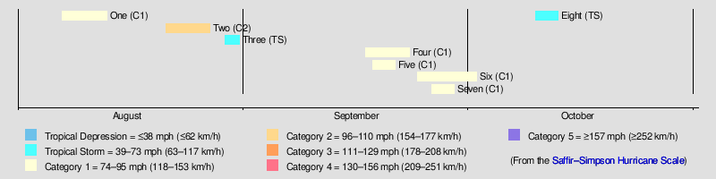
The Atlantic hurricane database (HURDAT) recognizes eight tropical cyclones for 1885 in the Atlantic basin; two were tropical storms and six were hurricanes, but none of these strengthened into a major hurricane.[1] Five of the systems made landfall in the United States.[3] José Fernández-Partagás and Henry F. Diaz did not add or remove any cyclones from their 1996 reanalysis, but modified the tracks of first, second, and eighth storms.[4] Furthermore, the Atlantic hurricane reanalysis project in the early 21st century neither adjusted the number of cyclones nor significantly revised the information uncovered by Fernández-Partagás and Diaz.[5] A reanalysis by climate researcher Michael Chenoweth, published in 2014, adds three storms and removes one, the sixth system. Chenoweth's study utilizes a more extensive collection of newspapers and ship logs. Additionally, the study also incorporates late 19th century weather maps, unlike previous reanalysis projects.[6] However, Chenoweth's proposals have yet to be incorporated into HURDAT.[3]
The first cyclone was initially detected on August7 to the southeast of Bermuda.[7] Intensifying into a hurricane, the system transitioned into an extratropical cyclone far north of the Azores on August13. Two other storms formed in August, including the season's second, which became the most intense in the basin that year, peaking as a Category2 hurricane with maximum sustained winds of 105mph (165km/h) and a minimum atmospheric pressure of 953mbar (28.1inHg). Striking South Carolina on August 15,[3] the storm led to 25fatalities and more than $1.806million in damage,[8][9] before re-entering the Atlantic and becoming extratropical on August27 east of Newfoundland. September featured four cyclones, all of which peaked as a Category1 hurricane.[3] The first of the four, the season's fourth system, killed four people after beaching a coal barge along the coast of Texas,[10] while the sixth cyclone caused flooding in New Orleans, Louisiana, and in Florida at Jacksonville and Pensacola.[11][12] In October, the eighth and final known storm of the season produced damage from Florida to Virginia due to strong winds, heavy rains, and rough seas.[13][14] The system transitioned into an extratropical cyclone on October13 over Virginia.[3]
The season's activity was reflected with an accumulated cyclone energy (ACE) rating of 58, the lowest total since 1876. ACE is a metric used to express the energy used by a tropical cyclone during its lifetime. Therefore, a storm with a longer duration will have higher values of ACE. It is only calculated at six-hour increments in which specific tropical and subtropical systems are either at or above sustained wind speeds of 39mph (63km/h), which is the threshold for tropical storm intensity. Thus, tropical depressions are not included in the metric.[1]
A brig known as Lilian first encountered this storm to the southeast of Bermuda on August7.[7] Consequently, the Atlantic hurricane database begins the track on that date about 500mi (805km) northeast of the Leeward Islands. Initially a tropical storm, it moved north-northeastward and strengthened into a hurricane on August8,[3] based on ships recording barometric pressures around 990mbar (29inHg).[5] The system turned to the northeast by August10, passing to the south of Newfoundland and likely peaking with maximum sustained winds of 90mph (150km/h),[3] as the bark King County observed barometric pressures as low as 975mbar (28.8inHg).[15][5] The hurricane weakened over the north Atlantic Ocean, falling to tropical storm intensity on August13 and becoming extratropical on the following day.[3] Climate researcher Michael Chenoweth's 2014study argued that this system developed on July30 to the south of the Cabo Verde Islands as a tropical depression. Additionally, the storm reached hurricane status about 30hours earlier than HURDAT indicates.[6]
Although observations prior to August23 could not be located,[16] HURDAT begins the track of this storm approximately 185mi (300km) north of Puerto Rico on August21,[3] based on a 1993 reanalysis led by C. J. Neumann.[16] The tropical storm moved generally westward and crossed the southern Bahamas, until curving north-northwestward while passing just west of Andros between August22 and August23. After intensifying into a hurricane early on August24, the cyclone passed very close to Florida, including just over 10mi (15km) east of Jupiter Island at 06:00UTC. The storm then curved northeastward early the next day, hours prior to making landfall on Kiawah Island, South Carolina. Based on a pressure observation of 974mbar (28.8inHg), the cyclone was likely a Category2 hurricane with winds of 105mph (165km/h). The hurricane passed across North Carolina just west of Wilmington and Hatteras, near where it re-emerged into the Atlantic early on August26. Although the storm weakened to a Category1 hurricane, it re-intensified into a 105mph (165km/h) Category2 hurricane,[3] based on the bark Harold recording a barometric pressure of 958mbar (28.3inHg).[17] Late on August27, the system transitioned into an extratropical cyclone about 290mi (470km) east of Newfoundland, and continued northeastward until dissipating late the next day.[3]
Chenoweth argued that this storm actually developed on August22 and moved northwestward, mostly avoiding the Bahamas but passing close to the Abaco Islands. The study also suggested that the cyclone attained hurricane on August24, but weakened to a Category2 hurricane before making landfall in North Carolina.[6] In Florida, abnormally high tides and "high winds pummeled the coast" according to Jay Barnes,[18] with a sustained wind speed of 60mph (95km/h) and hurricane-force wind gusts in Jacksonville.[19] Nearby, winds destroyed a hotel, while many buildings and boats suffered significant damage in Fernandina Beach.[20] The storm disrupted attempts to settle present-day Cocoa Beach, with waves flooding many homesteads. Nearby, severe erosion occurred in the vicinity of the Cape Canaveral Lighthouse, prompting an effort to move the lighthouse about 1mi (1.6km) farther inland.[18] Sustained winds in Georgia reached 56mph (90km/h) on Tybee Island.[19] About $1.69million in damage occurred in Charleston, South Carolina. In North Carolina, an anemometer at Smithville (modern-day Southport) measured a 5-minute sustained wind speed of 98mph (158km/h) before being destroyed. The storm caused considerable damage at Wilmington, Smithville, and Morehead City. The value of this damage was estimated at $100,000.[8] Heavy rain and flooding were also seen across Maryland. At Ellicott City, lightning set fire to a residence, causing about $16,000 in damage.[21] In total, the hurricane caused 25deaths,[9] with 21of those occurring in South Carolina.[22]
Tropical Storm Three
Tropical storm(SSHWS)
Duration
August 29– August 31
Peak intensity
60mph (95km/h) (1-min);
The Monthly Weather Review noted that this cyclone was first observed over the western Gulf of Mexico on August29 but notes that "the center could not be definitely placed until the morning of Aug. 30".[16] Nevertheless, the official track begins on the former date approximately 245mi (394km) east-southeast of the mouth of the Rio Grande. After initially moving northwestward, it moved quickly to the northeast and made landfall on extreme southeastern Louisiana shortly before 12:00UTC on August30 as a 60mph(95km/h) tropical storm. Approximately 11hours later, the cyclone made another landfall near Panama City Beach, Florida. The cyclone emerged into the Atlantic near Brunswick, Georgia, on August31 and was last noted later that day.[3] Parts of the Gulf Coast and Southeastern United States regions experienced high winds and heavy rains, though the Monthly Weather Review that "the storm would have been thought quite severe if it had not been brought into such close contact with its predecessor."[16] The 2014study by Chenoweth argued that the cyclone did not strike Louisiana and dissipated over coastal South Carolina on August31, rather than offshore.[6]
With Galveston, Texas, experiencing abnormally high tides as early as September17,[23] the official track for this cyclone starts approximately 120mi (195km) east-northeast of Tuxpan, Veracruz. The storm moved parallel to the coasts of Mexico and Texas, turning northward that day and northeastward on September19. By the following day, the cyclone accelerated east-northeastward. The system then made landfall near Port Eads, Louisiana, at 03:00UTC on September21 and then near Panama City Beach, Florida, about nine hours later, likely possessing sustained winds of 60mph (95km/h) at both locations. After emerging into the Atlantic near Kingsland, Georgia, late on September21, the storm curved northeastward on the following day and intensified into a hurricane.[3] Due to ships recording barometric pressures as low as 973mbar (28.7inHg), the system is estimated to have peaked with winds of 90mph (150km/h) on September23.[5] Later that day, however, the storm became extratropical just prior to making landfall in southeastern Maine.[3]
Chenoweth's 2014study concluded that this system struck neither Louisiana nor Florida, instead making landfall in Alabama and then turning eastward, dissipating over Georgia on September30.[6] As the storm moved parallel to Gulf of Mexico coastline, it flooded coastal towns, especially in Texas. Galveston observed more than 6in (150mm) of precipitation and coastal flooding. A coal barge Orient washed ashore, causing four deaths. The town of Indianola also experienced coastal flooding and sustained winds up to 45mph (72km/h).[10] Several coastal cities of Gulf Coast and Southeastern United States regions reported heavy precipitation.[23] The storm produced gales in Massachusetts, damaging many telegraph wires.[24] Damage to vessels and shipping occurred along the coast of Nova Scotia, including in Halifax and Lunenburg. Additionally, the cyclone prostrated telegraph wires and destroyed many bridges.[25]
The steamship Sirius recorded a barometric pressure of 999mbar (29.5inHg) in a storm east of the Leeward Islands on September18,[26] leading to the official track beginning about 400mi (645km) east-northeast of Barbados. Moving slowly northwestward, the tropical storm intensified into a hurricane on September19 and peaked with winds of 80mph(130km/h),[3] based on the Sirius reporting winds "blowing a hurricane", according to the Monthly Weather Review.[26] Thereafter, the cyclone moved generally northward and was last noted on September21 about 610mi (980km) southeast of Bermuda.[3] Chenoweth's study indicated that this storm moved northwestward until September23, when it began moving northeastward. After becoming extratropical offshore Massachusetts early that day, the remnants crossed Atlantic Canada before dissipating over Labrador on September24.[6]
Hurricane Six
Category 1hurricane(SSHWS)
Duration
September 24– October 2
Peak intensity
80mph (130km/h) (1-min);
The Monthly Weather Review reported the existence of this storm beginning on September24.[11] Drifting north-northwestward, the cyclone struck Louisiana's Chandeleur Islands late on September26 as a strong tropical storm. Early the next day, the system struck near Ocean Springs, Mississippi, and then turned eastward.[3] Using a model created by meteorologists John Kaplan and Mark DeMaria, the storm is estimated to have weakened to a tropical depression over the Florida Panhandle on September29.[5] Early on October1, the depression emerged into the Atlantic near Jacksonville and quickly re-intensified into a tropical storm as it turned northeastward.[3] Observations from the ship Lone Star indicate that the storm strengthened into a hurricane on October2,[5] peaking with winds of 80mph (130km/h). However, the storm was last noted that day roughly 75mi (120km) east of Salvo, North Carolina.[3]
Chenoweth's 2014 study argued that the Gulf of Mexico portion of the track of this storm should be deleted from HURDAT and the remaining path to be reclassified as extratropical.[6] The storm dropped heavy rainfall over the Gulf Coast of the United States, especially between New Orleans, Louisiana, and Pensacola, Florida.[11] Parts of the former flooded, while a section of the Louisville and Nashville Railroad was closed.[27] Farther east, Jacksonville, Florida, recorded at least 13in (330mm) of precipitation during a 96-hour period. Consequently, floods occurred across the First Coast region, disrupting traffic along five out of six railroads and damaging numerous bridges, country roads, and docks, as well as some private property.[12] Strong winds impacted the coasts of the Carolinas, including gusts of 70mph (110km/h) at Charleston, South Carolina.[28]
Although no observations for this storm exist prior to September28,[29] the official track begins about 600mi (965km) northeast of the Leeward Islands,[3] based on the 1993reanalysis led by C. J. Neumann.[29] Moving north-northwestward, the cyclone intensified into a hurricane by September29 and peaked with maximum sustained winds of 90mph (150km/h) at 12:00UTC,[3] with the ship Mistletoe observing a barometric pressure of 982mbar (29.0inHg).[5] However, the system was last noted later that day about 190mi (305km) south of Sable Island, Nova Scotia.[3] Chenoweth's 2014study theorized that the cyclone formed on September23 but moved much slower. The storm also held hurricane status from September26 to September28, weakening instead of strengthening on September29 and dissipating that day.[6]
Despite no record of this storm in Cuba, the Atlantic hurricane database initiated the track on October10 in the far southeastern Gulf of Mexico, matching Neumann's 1993 reanalysis.[3][30] After moving north-northwestward for about 24hours, the cyclone turned northeastward on the following day and made landfall between Horseshoe Beach and Suwannee, Florida, around 22:00UTC, with winds of 70mph (110km/h).[3]Cedar Key recorded a barometric pressure of 988mbar (29.2inHg).[29] By October13, the storm transitioned into an extratropical over central Virginia and persisted until dissipating over western New York early the next day.[3] The 2014study by Chenoweth suggested that this cyclone instead developed north of the Yucatán Channel as a tropical depression and dissipated over northern Virginia.[6]
In Florida, Cedar Key reported sustained winds of 48mph (77km/h).[29] Abnormally high tides generated by these winds flooded wharves and roads.[13] A washout occurred along a branch of the Savannah, Florida and Western Railway between Jacksonville, Florida, and Waycross, Georgia.[31] Heavy rains over eastern Georgia caused the Savannah River to rise significantly at Savannah, damaging railroads in that part of the state.[14] Gales of 44–56mph (71–90km/h) occurred along the North Carolina coast. High tides coincided with the storm's passage, inundating parts of New Bern and Smithville (present-day Southport), with floodwaters entering a few stores in the latter. The cyclone also wrecked a schooner at Hatteras Inlet.[8] In Virginia, high winds damaged structures in Norfolk, especially unfinished buildings. Observers in Delaware, New Jersey, New York, and Connecticut also reported elevated winds and tides.[14]
Other storms
Chenoweth proposed three other storms not currently listed in HURDAT. The first such system formed over the eastern Caribbean on October7. Moving north-northwestward, the cyclone crossed the Virgin Islands as a tropical depression. On October12, the system intensified into a tropical storm and turned eastward. Thereafter, the storm executed a cyclonic loop and then moved northeastward before dissipating on October18. That same day, an extratropical cyclone transitioned into a tropical storm over the eastern Atlantic south of the Azores. For approximately nine days, the storm moved erratically and fluctuated between tropical storm and tropical depression status before dissipating on October27. Chenoweth's third and final proposed cyclone developed on November8 just east of the Windward Islands. Moving northwestward, the system turned north-northeastward on November10, before dissipating that day.[6]
Season effects
This is a table of all of the known storms that have formed in the 1885 Atlantic hurricane season. It includes their duration, landfall, damages, and death totals. Deaths in parentheses are additional and indirect (an example of an indirect death would be a traffic accident), but were still related to that storm. Damage and deaths include totals while the storm was extratropical, a wave, or a low, and all of the damage figures are in 1885 USD.
↑Landsea, Christopher W. (2004). "The Atlantic hurricane database re-analysis project: Documentation for the 1851–1910 alterations and additions to the HURDAT database". In Murname, Richard J.; Liu, Kam-biu (eds.). Hurricanes and Typhoons: Past, Present and Future. New York City, New York: Columbia University Press. p.195. ISBN0-231-12388-4. Retrieved February 14, 2025.
123Roth, David M. (February 4, 2010). "Texas Hurricane History"(PDF). National Weather Service Camp Springs, Maryland. p.23. Retrieved January 22, 2025.
↑"The Storm in Florida". York Press. August 28, 1885. Retrieved October 2, 2024– via Newspapers.com.
12Roth, David M.; Cobb, Hugh (July 16, 2001). "Virginia Hurricane History". National Oceanic and Atmospheric Administration. Archived from the original on January 8, 2008. Retrieved October 2, 2024.
↑"The New Orleans Floods". St. Louis Daily Globe-Democrat. September 28, 1885. p.4. Retrieved January 25, 2025– via Newspapers.com.
↑1885 Storm 6(.XLS). Atlantic Oceanographic and Meteorological Laboratory (Report). National Oceanic and Atmospheric Administration. Retrieved January 25, 2025.
This page is based on this Wikipedia article Text is available under the CC BY-SA 4.0 license; additional terms may apply. Images, videos and audio are available under their respective licenses.