
The Suwannee River is a river that runs through south Georgia southward into Florida in the Southern United States. It is a wild blackwater river, about 246 miles (396 km) long. The Suwannee River is the site of the prehistoric Suwanee Straits that separated the Florida peninsula from the Florida panhandle and the rest of the continent.

Lynches River, named for Thomas Lynch, Jr., signer of the Declaration of Independence, rises in North Carolina near Waxhaw, North Carolina, at about 700 feet (210 m) elevation, flowing only a short distance to the South Carolina border, and thence to join the Great Pee Dee River near Johnsonville. It is about 140 mi (230 km) long and the drainage area is 1,030 square miles (2,700 km2).

The Rappahannock River is a river in eastern Virginia, in the United States, approximately 195 miles (314 km) in length. It traverses the entire northern part of the state, from the Blue Ridge Mountains in the west where it rises, across the Piedmont to the Fall Line, and onward through the coastal plain to flow into the Chesapeake Bay, south of the Potomac River.
The Swanson River (Dena'ina: Yaghetnu) is a stream, 40 miles (64 km) long, on the Kenai Peninsula of south-central Alaska in the United States. Beginning at Gene Lake in the Swanson Lakes district, it flows southwest then north to Number Three Bay on the Gompertz Channel of Cook Inlet.

Birch Creek is a 150-mile (240 km) tributary of the Yukon River in the U.S. state of Alaska. Beginning at the confluence of Ptarmigan and Eagle creeks near Porcupine Dome, it flows southwest, then south under the Steese Highway and into the Steese National Conservation Area. It then turns east, then north, again passing under the Steese Highway and entering the Yukon Flats National Wildlife Refuge. Turning northwest, it ends where it splits into two distributaries, Lower Mouth Birch Creek and Upper Mouth Birch Creek, near Birch Creek, Alaska. The distributaries flow into the Yukon River at separate locations downstream of Fort Yukon.

The Arthur R. Marshall Loxahatchee National Wildlife Refuge is a 145,188-acre (587.55 km2) wildlife sanctuary is located west of Boynton Beach, in Palm Beach County, Florida. It is also known as Water Conservation Area 1 (WCA-1). It includes the most northern remnant of the historic Everglades wetland ecosystem.

The Lower Suwannee National Wildlife Refuge (LSNWR) is part of the United States National Wildlife Refuge System. It is located in southeastern Dixie and northwestern Levy counties on the western coast of Florida, approximately fifty miles southwest of the city of Gainesville.
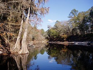
Suwannee River State Park is a Florida State Park located near Live Oak. It offers some of the best backcountry canoeing opportunities in the state. Visitors can see cypress trees, southern magnolia, herons, American coots, turtles and hawks. The park is open year-round.

The Okefenokee National Wildlife Refuge is a 402,000‑acre (1,627 km2) National Wildlife Refuge located in Charlton, Ware, and Clinch Counties of Georgia, and Baker County in Florida, United States. The refuge is administered from offices in Folkston, Georgia. The refuge was established in 1937 to protect a majority of the 438,000 acre (1,772 km2) Okefenokee Swamp. Though often translated as "land of trembling earth", the name "Okefenokee" is likely derived from Hitchiti oki fanôːki "bubbling water".

The Alapaha River is a 202-mile-long (325 km) river in southern Georgia and northern Florida in the United States. It is a tributary of the Suwannee River, which flows to the Gulf of Mexico.
Spring Creek is a 25.2-mile-long (40.6 km) tributary of Bald Eagle Creek in Centre County, Pennsylvania in the United States.

The Withlacoochee River originates in Georgia, northwest of Nashville, Georgia. It flows south through Berrien County where it joins the New River and forms part of the boundary between Berrien and Cook counties. It then flows south into Lowndes County, Georgia. At Troupville, Georgia the Little River joins the Withlacoochee River flows continues to flow south and forms part of the boundary between Lowndes and Brooks counties in Georgia. The river then flows into Florida for 1.34 miles before returning into Georgia for an additional 2.44 miles. It then returns to Florida, forming the northeast boundary of Madison County, Florida and the western boundary of Hamilton County, Florida and eventually merges with the Suwannee at Suwannee River State Park west of Live Oak. The river is 115 miles (185 km) long.

The Deep Fork River is an Oklahoma tributary of the North Canadian River. The headwaters flow from northern Oklahoma City and the river empties into the North Canadian River, now impounded by Lake Eufaula.

Stephen C. Foster State Park is a 120-acre state park in the Okefenokee Swamp in Charlton County, Georgia. The park offers visitors several ways to explore the swamp's unique ecosystem.

The Big Bend of Florida, United States, is an informally named geographic region of North Florida where the Florida Panhandle transitions to the Florida Peninsula south and east of Tallahassee. The region is known for its vast woodlands and marshlands and its low population density relative to much of the state. The area is home to the largest single spring in the United States, the Alapaha Rise, and the longest surveyed underwater cave in the United States, the 32-mile (51 km) Wakulla-Leon Sinks cave system.

The Kenai National Wildlife Refuge is a 1.92-million-acre (7,770 km2) wildlife habitat preserve located on the Kenai Peninsula of Alaska, United States. It is adjacent to Kenai Fjords National Park. This refuge was created in 1941 as the Kenai National Moose Range, but in 1980 it was changed to its present status by the Alaska National Interest Lands Conservation Act. The refuge is administered from offices in Soldotna.

Nantahala Township is located in North Carolina, United States in the part of Macon County which is west of Wayah Gap. It has a population of 1,711. "Nantahala" is a Cherokee word which means "The sun between them".

The Nature Coast State Trail (NCST) is a 31.7-mile long segment of Florida's Statewide System of Greenways and Trails System built along abandoned railroad tracks, and designated by the U.S. Department of the Interior as a National Recreation Trail. It has two primary sections following unused rail lines that were originally built by the Atlantic Coast Line Railroad. It includes historic sites such as a 1902 train trestle bridge over the Suwannee River near Old Town and train stations in Trenton, Cross City, and Chiefland. At Wilcox Junction abandoned rail tracks cross and connect with several communities. The trail is available to hikers, cyclists, and horse riders.

Malone Springs is a watershed within the Fremont-Winema National Forest in Klamath County, Oregon, U.S. It is 25 miles (40 km) northwest of Klamath Falls on Oregon Route 140. It provides access to a multi-mile canoe route along the westernmost edge of the Upper Klamath National Wildlife Refuge. Malone Springs' location allows for close encounters with the marsh of Upper Klamath Lake and views of old growth, mixed conifer forest on neighboring Pelican Butte immediately to the west.
Yellow Jacket is an unincorporated community alongside the Suwanee River in Dixie County, Florida. It is home to the Yellow Jacket RV Resort and a boat ramp. Yellow Jacket borders the Lower Suwannee National Wildlife Refuge's 20 mile estuarian preserve along the Suwannee River that continues southwest to the Gulf Coast. Yellow Jacket is off County Road 349 south of Old Town, Florida. A succession of timber companies including Putnam Lumber Company have been active in the area around Yellow Jacket. Large yellow jacket nests have been found in this region of Florida including one pictured 4 miles north of Tennille, Florida in 1953.

