Port Eads | |
|---|---|
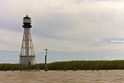 Lighthouse at Port Eads | |
 Port Eads Location of Port Eads in Louisiana | |
| Coordinates: 29°00′56.153″N89°10′15.776″W / 29.01559806°N 89.17104889°W | |
| Country | United States |
| State | Louisiana |
| Parish | Plaquemines |
| Elevation | 0 m (0 ft) |
| Time zone | UTC-6 (CST) |
| • Summer (DST) | UTC-5 (CDT) |
| Area code | 504 |
Port Eads is a populated place [1] at the southern tip of the Mississippi River, also known as South Pass, in Plaquemines Parish, Louisiana, United States. It was designated as a National Historic Civil Engineering Landmark by the American Society of Civil Engineers in 1982.

