Head of Passes is where the main stem of the Mississippi River branches off into three distinct directions at its mouth in the Gulf of Mexico: Southwest Pass (west), Pass A Loutre (east) and South Pass (centre). They are part of the "Bird's Foot Delta", the youngest lobe of the evolving Mississippi River Delta.
The Head of Passes is considered to be the location of the mouth of the Mississippi River.
The US Army Corps of Engineers maintains a 45-foot (13.7m) shipping channel from the mouth of Southwest Pass—20 miles (32km) downriver from the Head—up to Baton Rouge, the US's farthest inland deep-water port.[1]
The Mouth of Passes is the aggregate of the individual mouths of the passes connected to the Head of Passes, including the Southwest, South, North Passes and Pass a Loutre.[2] While the majority of the discharge of the Mississippi River flows through these mouths, a portion of the river flows out of the Atchafalaya River mouth, and a small portion continues to seep out of the 200 miles (300km) of the Delta shoreline.[3]
During the American Civil War, Head of Passes was the site of several naval battles. The Anaconda Plan called for a large Union blockade of the Confederacy, and included plans to control the Mississippi River. This began in 1861 with a Union blockade stationed at the Head of Passes. This occupation resulted in the Battle of the Head of Passes, where the blockading forces were temporarily driven from the area. Ships involved in the ensuing conflict at the location include the CSSManassas, the USSVincennes, and the USSRichmond.
Port Eads is located at the southern tip of South Pass.
AHP datum
The Head of Passes is the datum from which mileages on the Lower Mississippi River are measured.[4]Algiers Point, for instance, is at mile 94.6AHP (above Head of Passes). Cairo, Illinois, is at mile 953.8AHP. Mileages downstream from Head of Passes are labelled BHP (below Head of Passes).[5]
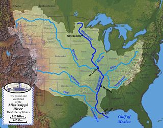
The Mississippi River is the second-longest river and chief river of the second-largest drainage system in North America, second only to the Hudson Bay drainage system. From its traditional source of Lake Itasca in northern Minnesota, it flows generally south for 2,340 miles (3,770 km) to the Mississippi River Delta in the Gulf of Mexico. With its many tributaries, the Mississippi's watershed drains all or parts of 32 U.S. states and two Canadian provinces between the Rocky and Appalachian mountains. The main stem is entirely within the United States; the total drainage basin is 1,151,000 sq mi (2,980,000 km2), of which only about one percent is in Canada. The Mississippi ranks as the thirteenth-largest river by discharge in the world. The river either borders or passes through the states of Minnesota, Wisconsin, Iowa, Illinois, Missouri, Kentucky, Tennessee, Arkansas, Mississippi, and Louisiana.
The Illinois River is a principal tributary of the Mississippi River and is approximately 273 miles (439 km) long. Located in the U.S. state of Illinois, it has a drainage basin of 28,756.6 square miles (74,479 km2). The Illinois begins at the confluence of the Des Plaines and Kankakee rivers in the Chicago metropolitan area, and it generally flows to the southwest across Illinois. Its drainage basin extends into southeastern Wisconsin, northwestern Indiana, and a very small area of southwestern Michigan in addition to central Illinois.
Pilottown is an unincorporated community in Plaquemines Parish, Louisiana, United States. It serves as a base for river pilots to guide ships across the bar and up and down the Mississippi River.
The first USS Arizona was an iron-hulled, side-wheel merchant steamship. Seized by the Confederate States of America in 1862 during the American Civil War, she was captured later the same year by the United States Navy.
USS Sciota was a Unadilla-class gunboat built on behalf of the United States Navy for service during the Civil War. She was outfitted as a gunboat, with both a 20-pounder rifle for horizontal firing, and two howitzers for shore bombardment, and assigned to the Union blockade of the waterways of the Confederate States of America.
The Mississippi River–Gulf Outlet Canal is a 76 mi (122 km) channel constructed by the United States Army Corps of Engineers at the direction of Congress in the mid-20th century that provided a shorter route between the Gulf of Mexico and New Orleans' inner harbor Industrial Canal via the Intracoastal Waterway. In 2005, the MRGO channeled Hurricane Katrina's storm surge into the heart of Greater New Orleans, contributing significantly to the subsequent multiple engineering failures experienced by the region's hurricane protection network. In the aftermath the channel was closed. A permanent storm surge barrier was constructed in the MRGO in 2009, and the channel has been closed to maritime shipping.
The Mississippi River Delta is the confluence of the Mississippi River with the Gulf of Mexico in Louisiana, southeastern United States. The river delta is a three-million-acre area of land that stretches from Vermilion Bay on the west, to the Chandeleur Islands in the east, on Louisiana's southeastern coast. It is part of the Gulf of Mexico and the Louisiana coastal plain, one of the largest areas of coastal wetlands in the United States. The Mississippi River Delta is the 7th largest river delta on Earth (USGS) and is an important coastal region for the United States, containing more than 2.7 million acres of coastal wetlands and 37% of the estuarine marsh in the conterminous U.S. The coastal area is the nation's largest drainage basin and drains about 41% of the contiguous United States into the Gulf of Mexico at an average rate of 470,000 cubic feet per second.
The inland waterways of the United States include more than 25,000 mi (40,000 km) of navigable waters. Much of the commercially important waterways of the United States consist of the Mississippi River System—the Mississippi River and connecting waterways.
The Mississippi River System, also referred to as the Western Rivers, is a mostly riverine network of the United States which includes the Mississippi River and connecting waterways. The Mississippi River is the largest drainage basin in the United States. In the United States, the Mississippi drains about fifty-nine percent of the country's rivers.
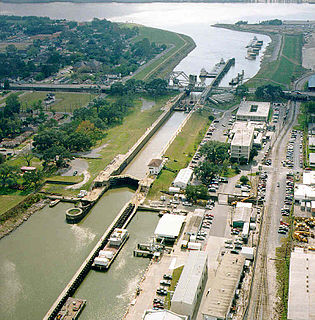
The Inner Harbor Navigation Canal Lock—commonly known as Industrial Canal Lock or simply Industrial Lock—is a navigation lock in New Orleans. It connects the Lower Mississippi River to the Industrial Canal and other sea-level waterways. Because it is shorter and narrower than most modern locks on the Mississippi River System, the 1920s vintage lock has become a bottleneck between the nation's two highest-tonnage waterways—the Mississippi and the Gulf Intracoastal Waterway.
The second Navy vessel to bear the name Sachem, this screw steamer was built in 1844 at New York City, where it was purchased by the Navy on 20 September 1861.
Big Black River is a river in the U.S. state of Mississippi and a tributary of the Mississippi River. Its origin is in Webster County near the town of Eupora in the north central part of the state. From there it flows 330 miles (530 km) in a generally southwest direction until it merges with the Mississippi River 25 miles (40 km) south of the city of Vicksburg. It is the major contributor to the Big Black River Basin. It forms part of the northern border of Choctaw County, passes through Montgomery County, and forms the eastern border of Holmes County and the northern border of Claiborne County.
USS Meteor was a gunboat acquired by the Union Navy during the American Civil War. She carried heavy artillery and became part of the sea blockade of waterways of the breakaway Confederate States of America.
USS Samuel Rotan was a schooner acquired by the Union Navy during the American Civil War. She was outfitted by the Union Navy as a gunboat to patrol navigable waterways of the Confederacy to prevent the South from trading with other countries. Prior to the war, the US Navy had mostly large, deep draft, oceangoing vessels. The establishment of the Union blockade required small, fast, shallow draft vessels like the Samuel Rotan for littoral operations.
USS Arletta was a schooner acquired by the Union Navy during the American Civil War. She was used by the Union Navy as a gunboat and, at times, an ammunition ship, in support of the Union Navy blockade of Confederate waterways.
A river mile is a measure of distance in miles along a river from its mouth. River mile numbers begin at zero and increase further upstream. The corresponding metric unit using kilometers is the river kilometer. They are analogous to vehicle roadway mile markers, except that river miles are rarely marked on the physical river; instead they are marked on navigation charts, and topographic maps. Riverfront properties are sometimes partially legally described by their river mile.
La Balize, Louisiana was a French fort and settlement near the mouth of the Mississippi River, in what later became Plaquemines Parish. The village's name meant "seamark." La Balize was historically and economically important for overseeing the river. It was rebuilt several times because of hurricane damage. The active delta lobe of the river's mouth is called the Balize Delta, after the settlement, or the Birdfoot Delta, because of its shape.
Wax Lake was a lake in St. Mary Parish, Louisiana that was converted into an outlet channel, the Wax Lake outlet, to divert water from the Atchafalaya River to the Gulf of Mexico.
The Battle of the Head of Passes was a bloodless naval battle of the American Civil War. It was a naval raid made by the Confederate river defense fleet, also known as the “mosquito fleet” in the local media, on ships of the Union blockade squadron anchored at the Head of Passes. The mosquito fleet deployed three fire rafts, which were ignited and followed the ironclad ram CSS Manassas into the action. The attack occurred after moonset in the early hours of October 12, 1861, and routed the Union fleet, which fled in disorder down the Southwest pass of the delta. After sunrise Commodore George N. Hollins, running low on ammunition and fuel, ordered the mosquito fleet to withdraw upriver.
Pass a Loutre Wildlife Management Area (WMA) is a 66,000-acre (270 km2) protected wetland in Plaquemines Parish, Louisiana, United States. The WMA is located due south and bordering the 48,000 acre Delta National Wildlife Refuge, accessible only by air or boat, contains the Pass A L'Outre Lighthouse, and Port Eads is within the boundary.
This page is based on this Wikipedia article Text is available under the CC BY-SA 4.0 license; additional terms may apply. Images, videos and audio are available under their respective licenses.