German submarine U-571 was a Type VIIC U-boat built for the Kriegsmarine of Nazi Germany for service during World War II. U-571 conducted eleven war patrols, sinking five ships totalling 33,511 gross register tons (GRT), and damaging one other for 11,394 GRT. On 28 January 1944 she was attacked by an Australian-crewed Sunderland aircraft from No. 461 Squadron RAAF west of Ireland and was destroyed by depth charges. All hands were lost.

Surcouf was a large French gun-armed cruiser submarine of the mid 20th century. She carried two 8" guns as well as anti-aircraft guns and a floatplane. Surcouf served in the French Navy and, later, the Free French Naval Forces during the Second World War.

The United States Asiatic Fleet was a fleet of the United States Navy during much of the first half of the 20th century. Before World War II, the fleet patrolled the Philippine Islands. Much of the fleet was destroyed by the Japanese by February 1942, after which it was dissolved, and the remnants incorporated into the naval component of the South West Pacific Area command, which eventually became the Seventh Fleet.

Apra Harbor, also called Port Apra, is a deep-water port on the western side of the United States territory of Guam. It is considered one of the best natural ports in the Pacific Ocean. The harbor is bounded by Cabras Island and the Glass Breakwater to the north and the Orote Peninsula in the south. Naval Base Guam and the Port of Guam are the two major users of the harbor. It is also a popular recreation area for boaters, surfers, scuba divers, and other recreationalists.
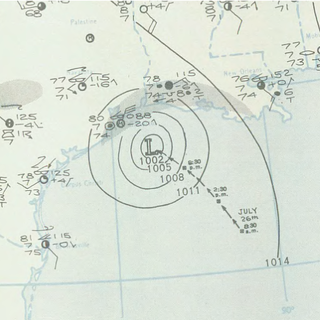
The 1943 Surprise hurricane was the first hurricane to be entered by a reconnaissance aircraft. The first tracked tropical cyclone of the 1943 Atlantic hurricane season, this system developed as a tropical storm while situated over the northeastern Gulf of Mexico on July 25. The storm gradually strengthened while tracking westward and reached hurricane status late on July 26. Thereafter, the hurricane curved slightly west-northwestward and continued intensifying. Early on July 27, it became a Category 2 hurricane on the modern-day Saffir–Simpson hurricane wind scale and peaked with winds of 105 mph (165 km/h). The system maintained this intensity until landfall on the Bolivar Peninsula in Texas late on July 27. After moving inland, the storm initially weakened rapidly, but remained a tropical cyclone until dissipating over north-central Texas on July 29.

Naval Station Argentia is a former base of the United States Navy that operated from 1941 to 1994. It was established in the community of Argentia in what was then the Dominion of Newfoundland, which later became the tenth Canadian province, Newfoundland and Labrador.
The American Theater was a theater of operations during World War II including all continental American territory, and extending 200 miles (320 km) into the ocean.

William Robert Munroe was a decorated officer in the United States Navy with the rank of Vice Admiral. He trained as submarine commander and at the beginning of World War II, he served as Commander, Battleship Division 3 during Neutrality Patrol in the Atlantic ocean.

Ship Island is a barrier island off the Gulf Coast of Mississippi, one of the Mississippi–Alabama barrier islands. Hurricane Camille split the island into two separate islands in 1969. In early 2019, the US Army Corps of Engineers completed the first stage of a project rejoining the two islands and recreating one Ship Island. Ship Island is the site of Fort Massachusetts, as a Third System fortification. Part of the island is included in the Gulf Islands National Seashore.

USS Balduck (APD-132) was a Crosley-class high speed transport of the United States Navy, named after Marine Corporal Remi A. Balduck (1918–1942), who was killed during the Battle of Guadalcanal. For his actions he was posthumously awarded the Navy Cross.

The Lower Mississippi River is the portion of the Mississippi River downstream of Cairo, Illinois. From the confluence of the Ohio River and Upper Mississippi River at Cairo, the Lower flows just under 1000 miles (1600 km) to the Gulf of Mexico. It is the most heavily travelled component of the Mississippi River System.

USS Isabel (SP-521), later PY-10, was a yacht in commission in the United States Navy as a destroyer from 1917 to 1920 and as a patrol yacht from 1921 to 1946.
United States ship naming conventions for the U.S. Navy were established by congressional action at least as early as 1862. Title 13, section 1531, of the U.S. Code, enacted in that year, reads, in part,
The vessels of the Navy shall be named by the Secretary of the Navy under direction of the President according to the following rule: Sailing-vessels of the first class shall be named after the States of the Union, those of the second class after the rivers, those of the third class after the principal cities and towns and those of the fourth class as the President may direct.

The Battle of the Caribbean refers to a naval campaign waged during World War II that was part of the Battle of the Atlantic, from 1941 to 1945. German U-boats and Italian submarines attempted to disrupt the Allied supply of oil and other material. They sank shipping in the Caribbean Sea and the Gulf of Mexico and attacked coastal targets in the Antilles. Improved Allied anti-submarine warfare eventually drove the Axis submarines out of the Caribbean region.

Patrick Nieson Lynch Bellinger was a highly decorated officer in the United States Navy with the rank of Vice Admiral. A Naval aviator and a naval aviation pioneer, he participated in the Trans-Atlantic flight from Newfoundland to Azores in May 1919 and was decorated with Navy Cross, the United States military's second-highest decoration awarded for valor.
The Observer Group was a joint-United States Army/Marine Corps unit that was the first in the United States and Fleet Marine Force to be organized and trained specifically for amphibious reconnaissance. The Observer Group experimented in the methodology and equipment for projecting reconnaissance from the sea before the establishment of the OSS Maritime Unit, the Underwater Demolition Teams, and before the Army Special Forces and Air Commandos. It was also the birth of naval amphibious intelligence.

I-9 was an built for the Imperial Japanese Navy Type A1 submarine commissioned in 1941. She saw service during World War II, including operations related to the attack on Pearl Harbor, a patrol off the United States West Coast, and in Operation K. She also took part in the Aleutians campaign and the Guadalcanal campaign before she was sunk in June 1943.

Naval Base Trinidad, also called NAS Trinidad, NAS Port-of-Spain, was a large United States Navy Naval base built during World War II to support the many naval ships fighting and patrolling the Battle of the Atlantic. The fighting in the area became known as the Battle of the Caribbean. Naval Base Trinidad was located on the Island of Trinidad in West Indies of the Caribbean Sea.

Naval Base Manila, Naval Air Base Manila was a major United States Navy base south of the City of Manila, on Luzon Island in the Philippines. Some of the bases dates back to 1898, the end of the Spanish–American War. Starting in 1938 civilian contractors were used to build new facilities in Manila to prepare for World War II. Work stopped on December 23, 1941, when Manila was declared not defendable against the Empire of Japan southward advance, which took over the city on January 2, 1942, after the US declared it an Open city. US Navy construction and repair started in March 1945 with the taking of Manila in the costly Battle of Manila ending on March 2, 1945. Naval Base Manila supported the Pacific War and remained a major US Naval Advance Base until its closure in 1971.


