Phoenix is an unincorporated community in Plaquemines Parish, Louisiana, United States.
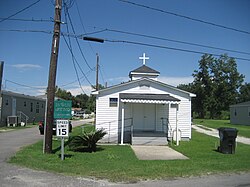
Phoenix is located on the east bank of the Mississippi River on Louisiana Highway 39, on the opposite side of the River from Myrtle Grove. It is the closest town to Fort De La Boulaye Site, a National Historic Landmark.
Plaquemines Parish School Board operates public schools. Phoenix High School in Phoenix serves grades K-12. [1]
St. Bernard Parish is a parish in the U.S. state of Louisiana. The parish seat and largest community is Chalmette. The parish was formed in 1807. St. Bernard Parish is part of the New Orleans–Metairie metropolitan statistical area; the parish is located southeast of the city of New Orleans and comprises the Chandeleur Islands and Chandeleur Sound in the east.
Plaquemines Parish is a parish located in the U.S. state of Louisiana. With a population of 23,515 at the 2020 census, the parish seat is Pointe à la Hache and the largest community is Belle Chasse. The parish was formed in 1807.
Iberville Parish is a parish located south of Baton Rouge in the U.S. state of Louisiana, formed in 1807. The parish seat is Plaquemine. The population was 30,241 at the 2020 census.
Plaquemine is a city in and the parish seat of Iberville Parish, Louisiana, United States. It is part of the Baton Rouge metropolitan statistical area. At the 2010 United States census, the population was 7,119; the 2020 census determined its population was 6,269.
Rosedale is a village in Iberville Parish, Louisiana, United States. The population was 664 in 2020. It is part of the Baton Rouge metropolitan statistical area.
Belle Chasse is a census-designated place (CDP) in Plaquemines Parish, Louisiana, United States, on the west bank of the Mississippi River. Belle Chasse is part of the Greater New Orleans metropolitan area. The population was 10,579 at the 2020 United States census. Belle Chasse is the largest community in Plaquemines Parish. It is home to Naval Air Station Joint Reserve Base New Orleans, a Naval Air Station for the U.S. Navy Reserve.
Boothville-Venice is a former census-designated place (CDP) in Plaquemines Parish, Louisiana, United States, which includes the unincorporated communities of Boothville, Venice, and Orchard. The population was 2,220 at the 2000 census. For the 2010 census, Boothville-Venice was split into the CDPs of Boothville and Venice.
Buras-Triumph is a former census-designated place in Plaquemines Parish, Louisiana, United States. The population was 3,358 at the 2000 census. For the 2010 census, Buras-Triumph was split into the CDPs of Buras and Triumph. On the peninsula, Buras has been located higher, with Triumph located southeast of Buras.
Empire is a census-designated place (CDP) in Plaquemines Parish, Louisiana, United States. The population was 905 at the 2020 census.
Port Sulphur is a census-designated place (CDP) on the West Bank of the Mississippi River in Plaquemines Parish, Louisiana, United States; at the 2020 census, it had a population of 1,677.
Venice is an unincorporated community and census-designated place in Plaquemines Parish, Louisiana, United States. As of the 2020 census, its population was 162. It is 77 miles (124 km) south of New Orleans on the west bank of the Mississippi River at 29°16′37″N89°21′17″W. It is the last community down the Mississippi accessible by automobile, and it is the southern terminus of the Great River Road. This has earned the town the nickname "The end of the world." The ZIP code for Venice is 70091.
The Pointe à la Hache Ferry or Pointe a la Hache Ferry, is a ferry across the Mississippi River in the U.S. state of Louisiana, connecting West Pointe à la Hache and Pointe à la Hache in Plaquemines Parish, Louisiana. Currently, it is $1 for single or double axle vehicles, three or more axles are $2. It is the last vehicle crossing of the river in the down river direction. The East Bank side of the ferry is near the end of paved roadway; on the West Bank the river road continues down to Venice, Louisiana. As the eastbank of Plaquemines Parish has little population in the aftermath of Hurricane Katrina, ferry service to the eastbank occurs at the top of every hour between 6 AM and 10 PM, as well as at 6:30 AM. Likewise, ferry service to the westbank occurs at 6:15 AM, 6:45 AM, and on the bottom of every hour between 7:30 AM and 10:30 PM.
West Pointe à la Hache is an unincorporated community in Plaquemines Parish, Louisiana, United States.
Woodland Plantation, in West Pointe à la Hache, Louisiana, is a historic building and a former plantation house. It is located at 21997 Louisiana Highway 23 in West Pointe à la Hache, in Plaquemines Parish, Louisiana. This sugar plantation was once worked by enslaved people. It has been listed on the National Register of Historic Places since June 18, 1998.
Southwest Pass is one of the channels at the mouth of the Mississippi River. It empties into the Gulf of Mexico at the southwesternmost tip of the Mississippi River Delta. It lies in Plaquemines Parish in southeastern Louisiana in the United States. It has been the main shipping channel in the Mississippi River Delta since 1853.
The Port of Plaquemines is one of the largest seaports in the United States. It is located at the mouth of the Mississippi River on the Gulf of Mexico, near Belle Chasse in Plaquemines Parish, Louisiana, about twenty miles south of New Orleans.
Ironton is an unincorporated community in Plaquemines Parish, Louisiana, United States.
Davant is an unincorporated community located in the delta of the Mississippi River in the parish of Plaquemines, Louisiana, United States.
Bohemia is a small unincorporated community located in the delta of the Mississippi River in the parish of Plaquemines, Louisiana, United States. The unincorporated community was affected in 2005 by Hurricane Katrina. Before Katrina made landfall, the community had a population of about 200 people, but the hurricane left only 25 homes standing.
Braithwaite is an unincorporated community in Plaquemines Parish, Louisiana, United States. Braithwaite is located on the Mississippi River and Louisiana Highway 39 in northern Plaquemines Parish, 9.6 miles (15.4 km) southeast of New Orleans. Braithwaite has a post office with ZIP code 70040, which opened on September 19, 1902. Two of the first deaths in the United States caused by Hurricane Isaac in 2012 occurred in Braithwaite, where a couple drowned in their home on August 30.
29°38′46″N89°56′23″W / 29.64611°N 89.93972°W