1997 Atlantic hurricane season

Last updated

1997 Atlantic hurricane season
1997 Atlantic hurricane season summary map.png
Season summary map
Seasonal boundaries
First system formedJune 1, 1997
Last system dissipatedOctober 17, 1997
Strongest storm
Name Erika
  Maximum winds125 mph (205 km/h)
(1-minute sustained)
  Lowest pressure946 mbar (hPa; 27.94 inHg)
Seasonal statistics
Total depressions9
Total storms8
Hurricanes3
Major hurricanes
(Cat. 3+)
1
Total fatalities12 total
Total damage$111.46 million (1997 USD)
Related articles
Atlantic hurricane seasons
1995, 1996, 1997, 1998, 1999

The 1997 Atlantic hurricane season was a below-average hurricane season. It officially began on June 1, [1] and lasted until November 30 of that year. [2] These dates conventionally delimit the period of each year when most tropical cyclones form in the Atlantic basin. The 1997 season was fairly inactive, with only seven named storms forming, with an additional tropical depression and an unnumbered subtropical storm. It was the first time since the 1961 season that there were no active tropical cyclones in the Atlantic basin during the entire month of Augusthistorically one of the more active months of the seasona phenomenon that would not occur again until 2022. A strong El Niño is credited with reducing activity in the Atlantic, while increasing the number of storms in the eastern and western Pacific basins to 19 and 26 storms, respectively. As is common in El Niño years, tropical cyclogenesis was suppressed in the tropical latitudes, with only two becoming tropical storms south of 25°N.

Contents

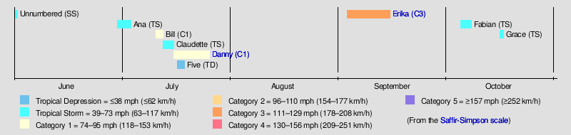
The first system, an operationally unnoticed subtropical storm, developed north of the Bahamas on June 1 and dissipated by the following day without any impact. Tropical Storm Ana developed offshore South Carolina on June 30 and dissipated on July 4, after causing minor affects in North Carolina. Hurricane Bill was a short-lived storm between that lasted from July 11 to July 13 and produced light rainfall in Newfoundland. As Bill was dissipating, Tropical Storm Claudette developed and generated rough seas in North Carolina. The most devastating storm was Hurricane Danny, which caused extensive flooding, particularly in southern Alabama. Danny resulted in 9 fatalities and about $100 million (1997  USD) in damage. The outer bands of Hurricane Erika brought rough seas and gusty winds to the Lesser Antilles, resulting in two deaths and $10 million in losses. The precursor to Tropical Storm Grace caused flooding in Puerto Rico, while Tropical Depression Five and Tropical Storm Fabian did not impact any land. Collectively, the storms of the 1997 Atlantic hurricane season resulted in 12 fatalities and approximately $111.46 million in damages.

Seasonal forecasts

Predictions of tropical activity in the 1997 season
SourceDateNamed
storms
HurricanesMajor
hurricanes
Ref
Average (1981–2010)12.16.42.7 [3]
Record high activity 30 15 7 [4]
Record low activity 1 0 0 [4]

CSU December 6, 19961173 [5]
WRCEarly 199774N/A [6]
CSUApril 4, 19971173 [7]
CSUMay 30, 19971173 [2]
CSUAugust 6, 19971162 [8]
Actual activity
831
† Most recent of several such occurrences. (See all)

Forecasts of hurricane activity are issued before each hurricane season by noted hurricane experts such as Dr. William M. Gray and his associates at Colorado State University (CSU), as well as the Weather Prediction Center (WPC). As stated by the National Oceanic and Atmospheric Administration (NOAA), an Atlantic hurricane season between 19812010 contained roughly twelve tropical storms, six hurricanes, three major hurricanes, and an accumulated cyclone energy (ACE) index of 66103 units. [3] NOAA typically categorizes a season as either above-average, average, of below-average based on the cumulative ACE Index; however, the number of tropical storms, hurricanes, and major hurricanes within a hurricane season is considered occasionally as well. [9]

CSU's first outlook for the season, issued in December 1996, predicted eleven named storms, seven hurricanes, and three major hurricanes, which are defined as a tropical cyclone reaching at least a Category 3 rating on the Saffir–Simpson Hurricane Scale. [5] These numbers went unchanged during their forecast updates released in April and May. [7] [2] CSU issued these predictions based on the possibility of El Niño weakening, [2] a cessation of drought conditions over the Sahel, and nearly identical trade wind and atmospheric pressure patterns compared to the previous season. [7] In August, however, CSU slightly decreased their predicted number of hurricanes and major hurricanes to six and two, respectively, after the El Niño strengthened instead. [8] In early 1997, the WRC anticipated a less active season, forecasting seven named storms and four hurricanes, but issuing no prediction on the number of major hurricanes. [6]

Seasonal summary

Hurricane Erika (1997)Hurricane Danny (1997)Saffir-Simpson scale1997 Atlantic hurricane season
Map of rainfall totals from Hurricane Danny in the United States Danny 1997 rainfall.gif
Map of rainfall totals from Hurricane Danny in the United States

The Atlantic hurricane season officially began on June 1, [2] and an unnamed subtropical storm developed on the same day. Only nine tropical depressions formed. Eight of the depressions attained tropical storm status, making 1997 the least active Atlantic hurricane season in the ongoing above-average era of tropical cyclogenesis, which began in 1995. Just three of these systems attained hurricane status and only one tropical cyclone intensified into a major hurricane, [10] which was below the 19812010 average of three per season. [3] Only Danny made landfall at hurricane strength during the season, although Hurricane Erika and Tropical Storm Grace also caused damage and fatalities. Those three cyclones collectively caused 12 deaths and $111.46 million in damage. [10] [11] [12] [13] [14] [15] The last storm of the season, Tropical Storm Grace, dissipated on October 17, over a month before the official end of the season on November 30. [10]

The 1997 Atlantic hurricane season had a very active beginning. In June, two tropical cyclones developed – the unnoticed subtropical storm and Tropical Storm Ana. An unusual four tropical cyclones formed in the month of July, three of which reached tropical storm intensity, and two of them became hurricanes. Despite the active start, the other months of the season featured record low activity, especially in August and September, both of which combined produced only one tropical cyclone. As a result of the active start and subsequent lack of activity, it showed that early season activity has no correlation to the entire season. [10] Further, this marked the first occurrence of no tropical cyclogenesis in August since 1961, [16] and the most recent instance of no activity in that month until 2022. [17] The lone tropical cyclone during the period was Hurricane Erika, which developed on September 3. In October, two short-lived tropical cyclones developed, Fabian and Grace. Tropical cyclogenesis ceased after Grace transitioned into an extratropical cyclone on October 17. [10]

The season's activity was reflected with a low accumulated cyclone energy (ACE) rating of 41. ACE is, broadly speaking, a measure of the power of the hurricane multiplied by the length of time it existed, so storms that last a long time, as well as particularly strong hurricanes, have high ACEs. It is only calculated for full advisories on tropical systems at or exceeding 39 mph (63 km/h), which is the threshold for tropical storm strength. [18]

Systems

Unnamed subtropical storm

Subtropical storm (SSHWS)
Unnamed Subtropical Storm (1997).JPG   1997 Atlantic subtropical storm 1 track.png
DurationJune 1 – June 2
Peak intensity50 mph (85 km/h) (1-min);
1003  mbar  (hPa)

A cluster of thunderstorms developed over Florida in late May. A shortwave trough brought it to the northeast, enhancing convection around a developing center of circulation. The low pressure area, which formed on May 31, developed into a subtropical depression on June 1. Operationally, it was treated as a frontal low, but post-analysis suggested it remained separate throughout its lifetime, and was classified as an unnamed subtropical storm. It reached subtropical storm strength six hours later as it moved rapidly parallel to the East Coast of the United States. The convection continued to wrap around the center, and despite unfavorable conditions from an approaching cold front it continued to intensify. Late on June 1, it reached its peak intensity with maximum sustained winds of 50 mph (85 km/h) while off the coast of North Carolina. The storm turned to the east, and transitioned extratropical late on June 2 southeast of Massachusetts. Shortly thereafter, the remnants of the storm merged with a cold front. [19]

Tropical Storm Ana

Tropical storm (SSHWS)
Ana 1997-07-01 1545Z.png   Ana 1997 track.png
DurationJune 30 – July 4
Peak intensity45 mph (75 km/h) (1-min);
1000  mbar  (hPa)

A frontal low pressure system off the coast of South Carolina developed into Tropical Depression One at 1200 UTC on June 30. It moved slowly eastward, and attained tropical storm status on July 1. After becoming a tropical storm, Ana slightly intensified. Early on July 2, Ana attained its peak intensity with maximum sustained winds of 45 mph (75 km/h) and a minimum central pressure of 1,000  mbar (30  inHg ). Later on July 2, a shortwave trough forced Ana to northeastward, into a region of increasing vertical wind shear. Simultaneously, Ana began to weaken, as it was moving into an area of decreasing sea surface temperatures. [20]

By late on July 3, Ana weakened to a tropical depression. The storm also lost tropical characteristics and transitioned into an extratropical cyclone early on July 4, over the western Atlantic Ocean. The extratropical remnants persisted until dissipating about twenty-four hours later. [20] Minimal impact was reported as a result of Ana, other than rip currents in coastal North Carolina. Due to the rough seas, 14 rescues and one serious injury occurred at Carolina Beach. In addition, five rescues were made at Kure Beach and at least one person was hospitalized. However, there were no fatalities at either location. [21]

Hurricane Bill

Category 1 hurricane (SSHWS)
Hurricane Bill Jul 12 1997 1515Z.jpg   Bill 1997 track.png
DurationJuly 11 – July 13
Peak intensity75 mph (120 km/h) (1-min);
986  mbar  (hPa)

A large upper-level low separated from a trough north of Puerto Rico in early July. Convection increased on July 7 after a surface trough developed, and a low pressure area formed east of the Bahamas once the upper-level low retreated to the southwest. Wind shear decreased across the region, allowing the convection to increase and organize, and it is estimated the system developed into a tropical depression on July 11 about 330 mi (530 km) southwest of Bermuda. After developing, the cyclone moved northeastward in advance of an approaching cold front. It quickly intensified into Tropical Storm Bill, and briefly threatened to pass near Bermuda. As a result, a tropical storm warning was issued, although it was quickly dropped; there was no impact on the island from Bill. [22]

Bill quickly intensified as it continued northeastward. By midday on July 12, an eye feature was observed on satellite images, which suggested that Bill intensified into hurricane status at a relatively high latitude. Bill had in fact intensified into a hurricane, and the storm had attained its peak intensity with maximum sustained winds of 75 mph (120 km/h) and a minimum pressure of 986 mbar (29.1 inHg). After only 12 hours at hurricane status, Bill weakened back to tropical storm status, and on July 13 was absorbed by the cold front about 185 mi (300 km) south of Cape Race, Newfoundland. [22] Bill dropped very light rainfall on Newfoundland, peaking at slightly less than 1 in (25 mm). [23]

Tropical Storm Claudette

Tropical storm (SSHWS)
Claudette 1997-07-14 1545Z.png   Claudette 1997 track.png
DurationJuly 13 – July 17
Peak intensity45 mph (75 km/h) (1-min);
1003  mbar  (hPa)

The frontal system that influenced the track of Hurricane Bill spawned a non-tropical low off the southeast United States on July 11. The low remained nearly stationary as the front dissipated, and it developed into Tropical Depression Three on July 13 about 325 mi (525 km) south-southeast of Wilmington, North Carolina. The depression quickly intensified into Tropical Storm Claudette, based on reconnaissance aircraft data. It moved northeastward, passing southeast of the Outer Banks. Despite the presence of wind shear it developed banding features. On July 14, the storm reached peak winds of 45 mph (75 km/h). Thereafter, Claudette turned eastward ahead of a frontal system. [24]

Its associated thunderstorm activity was sporadic and relatively disorganized, and the storm weakened to a tropical depression on July 16. Claudette briefly re-intensified into a tropical storm before becoming extratropical later that day. Shortly thereafter, it merged with a cold front, while the remnants were last noted near the Azores on July 23. [24] Tropical Storm Claudette had minimal effects on land. [25] Severe rip currents from Claudette in North Carolina caused several rescues and one person was injured, although no fatalities occurred. [21] Some residents of coastal North Carolina were even disappointed that Claudette was to remain offshore, as the region was suffering from dry conditions. [26]

Hurricane Danny

Category 1 hurricane (SSHWS)
Danny 1997-07-19 1445Z.png   Danny 1997 track.png
DurationJuly 16 – July 26
Peak intensity80 mph (130 km/h) (1-min);
984  mbar  (hPa)

A tropical low over the northern Gulf of Mexico developed into Tropical Depression Four on July 16. The depression headed slowly east-northeastward, and intensified into Tropical Storm Danny on the following day. Danny continued east-northeastward, and reached hurricane strength just before landfall near Buras, Louisiana. Because of the narrowness of that piece of land, most of Danny remained over water and it lost little strength. Danny re-emerged into the Gulf of Mexico, and strengthened slightly making two landfalls in Alabama as a low-end Category 1 hurricane on July 19. After remaining stationary for a day, Danny moved northward and weakened to a tropical depression. Heading northward across Alabama, Danny turned to the east and crossed over the Southeastern United States. While centered over North Carolina, Danny interacted with a developing trough, which caused it to re-intensify into a tropical storm. Shortly thereafter, Danny emerged over the Atlantic Ocean near the North Carolina Virginia border on July 24. Danny took a northward turn, and came within 30 mi (50 km) of Nantucket Island on July 26. It then turned out to sea and was absorbed by a front on July 27. [11]

Although Danny was a hurricane upon landfall, strong winds were confined to a small area, with only portions of extreme eastern Louisiana reporting hurricane-force winds. [27] [28] Danny also dropped torrential amounts of rain in Louisiana, peaking at 11.40 in (290 mm) in Buras-Triumph. [29] Flooding occurred in portions of the state due to heavy rainfall. The floods and high winds produced by Danny damaged over 300 houses and more than 170 businesses in Louisiana alone. [27] [28] In Mississippi, Danny dropped heavy rainfall on the southern portion of the state, resulting in minor street and house flooding. [30] As Danny crossed Dauphin Island, Alabama on July 19, it dropped 37.75 in (960 mm) of rain. This made Danny the wettest tropical cyclone on record in Alabama. [29] [31] Hurricane force-winds were reported on Dauphin Island and the western shores of Mobile Bay. In the same area, many buildings had sustained roof damage. In addition, many homes on the Fowl and Fish Rivers reported significant damage. [32] Further north in South Carolina and Virginia, Danny spawned several tornadoes; some of them caused significant damage. [33] Heavy rainfall also occurred in some isolated areas; in central North Carolina between 8–12 in (200–300 mm) of rain was reported. Danny eventually affected Massachusetts, bring light rainfall [29] and tropical storm-force winds to the southeastern portions of the state. [27] [34] Overall, Danny caused nine fatalities, and approximately $100 million in damage. [11]

Tropical Depression Five

Tropical depression (SSHWS)
Tropical Depression 05L Jul 7 1997 1815Z.jpg   5-L 1997 track.png
DurationJuly 17 – July 19
Peak intensity35 mph (55 km/h) (1-min);
1008  mbar  (hPa)

A tropical wave emerged into the Atlantic Ocean from the west coast of Africa on July 11. The wave moved westward across the tropical Atlantic, and finally began to show consistent evidence of a cloud system center. Deep convection associated with the wave became concentrated on satellite images on July 17, and it is estimated that the disturbance became Tropical Depression Five around 0600 UTC on that day while centered about 547 mi (880 km) east of Barbados. The tropical depression moved west-northwestward and started showing signs of falling apart on July 18. Early on the following day, the depression degenerated into a tropical wave. Recon observations before the storm fell apart suggested that it may have briefly reached tropical storm strength. The tropical wave continued westward without regenerating and lost its identity on July 23 over the eastern Gulf of Mexico. [35]

Hurricane Erika

Category 3 hurricane (SSHWS)
Hurricane Erika Sep 9 1997 1744Z.jpg   Erika 1997 track.png
DurationSeptember 3 – September 15
Peak intensity125 mph (205 km/h) (1-min);
946  mbar  (hPa)

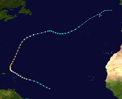
A tropical wave, which would later also develop Hurricane Nora, developed into Tropical Depression Six while it was centered about 1,150 mi (1,850 km) east of the southernmost Lesser Antilles on September 3. Later that day, the depression intensified enough to be upgraded to Tropical Storm Erika. It moved west-northwestward and steadily intensified to attain hurricane status on September 4. Erika passed a short distance to the north of the Lesser Antilles, and later turned to the north in response to an approaching trough. The hurricane quickly strengthened to reach peak winds of 125 mph (205 km/h) on September 8, and after maintaining peak strength for 24 hours Erika weakened over cooler waters. It turned to the east, weakened to a tropical storm, and became extratropical after passing near the Azores on September 15. [12]

The hurricane produced light rainfall and winds throughout the northern Lesser Antilles. [12] The passage of Erika brought a cloud of ash to Antigua from the eruption of the Soufrière Hills Volcano on Montserrat, a rare occurrence. Strong waves from the hurricane produced beach erosion and coastal flooding in northern Puerto Rico, and killed two surfers. [12] Moderate wind gusts in Puerto Rico left thousands without power, [36] and the hurricane resulted in $10 million in damage to the Caribbean territory of the United States. [13] Erika also produced gusty winds and light rain in the Azores. Later in its duration, the storm brought hurricane-force wind gusts and rainfall to the Azores, though no damage was reported. [12] Erika was the only tropical cyclone in the Atlantic basin in the month of September in this year, the first such occurrence in a hurricane season since 1929. [37]

Tropical Storm Fabian

Tropical storm (SSHWS)
Tropical Storm Fabian Oct 6 1997 1815Z.jpg   Fabian 1997 track.png
DurationOctober 4 – October 8
Peak intensity40 mph (65 km/h) (1-min);
1004  mbar  (hPa)

A tropical wave emerged into the Atlantic Ocean from the west coast of Africa near Dakar, Senegal on September 22. The wave traveled westward with minimal tropical cyclogenesis and reached the Lesser Antilles about a week later. While passing through the islands, heavy rainfall and strong winds were reported. Eventually, the system developed into a broad area of low pressure and acquired a low-level circulation. However, upper-level wind shear resulted in no immediate further organization. After crossing Puerto Rico and the Virgin Islands, wind shear decreased, since the low was moving in the same direction as the upper-level winds. [38]

At 1800 UTC October 4, it is estimated that system developed into Tropical Depression Seven, while 410 mi (660 km) north of Puerto Rico. [38] However, the National Hurricane Center did not initiate advisories until 1500 UTC on October 7. [39] The depression strengthened and about 24 hours after forming, it became Tropical Storm Fabian later on October 5. No further significant change in intensity occurred for the remainder of its duration, as Fabian had peaked with winds of 40 mph (65 km/h). The storm began losing tropical characteristics and transitioned into an extratropical cyclone at 1200 UTC on October 8. [38]

Tropical Storm Grace

Tropical storm (SSHWS)
Tropical Storm Grace Oct 15 1997 1915Z.jpg   Grace 1997 track.png
DurationOctober 16 – October 17
Peak intensity45 mph (75 km/h) (1-min);
999  mbar  (hPa)

An extratropical low formed just north of Hispaniola on October 14, and on the following day, it attained gale-force winds. In addition, the system was also acquiring tropical characteristics, and was classified as Tropical Storm Grace on October 16 at 0000 UTC. Strong vertical wind shear prevented further intensification, and Grace immediately peaked with maximum sustained winds of 45 mph (75 km/h) and a minimum barometric pressure of 999 mbar (29.5 inHg). Though Grace was classified as a tropical cyclone, it still held onto some extratropical characteristics. Thereafter, Grace steadily weakened and eventually degenerated into an extratropical low on October 17. [40]

The precursor disturbance of Grace dropped moderate to heavy rainfall across Puerto Rico, peaking at 12.69 in (320 mm) in Aibonito. [41] As a result, flash flooding occurred throughout the island of Puerto Rico, while landslides caused damage to roads and bridges. In addition, numerous rivers overflowed their banks, which forced 37 people to seek shelter across the island. [42] One fatality occurred, [14] and damage amounted to $1.46 million. [15] In addition, the extratropical system produced light to moderate rainfall in the U.S. Virgin Islands, and precipitation reached 7 in (180 mm) along western sides of the islands. [41]

Storm names

The following list of names was used for named storms that formed in the north Atlantic in 1997. [43] [44] This is the same list used for the 1991 season, [45] except for Bill, which replaced Bob . [46] A storm was named Bill for the first time in 1997. There were no names retired from this list after the season, [47] so it was used again for the 2003 season. [48]

  • Henri (unused)
  • Isabel (unused)
  • Juan (unused)
  • Kate (unused)
  • Larry (unused)
  • Mindy (unused)
  • Nicholas (unused)
  • Odette (unused)
  • Peter (unused)
  • Rose (unused)
  • Sam (unused)
  • Teresa (unused)
  • Victor (unused)
  • Wanda (unused)

Season effects

This is a table of all of the storms that formed in the 1997 Atlantic hurricane season. It includes their duration (within the basin), names, areas affected, damages, and death totals. Deaths in parentheses are additional and indirect (an example of an indirect death would be a traffic accident), but were still related to that storm. Damage and deaths include totals while the storm was extratropical, a wave, or a low, and all of the damage figures are in 1997 USD.

Saffir–Simpson scale
TDTSC1C2C3C4C5
1997 North Atlantic tropical cyclone season statistics
Storm
name
Dates activeStorm category
at peak intensity
Max 1-min
wind
mph (km/h)
Min.
press.
(mbar)
Areas affectedDamage
(USD)
DeathsRef(s)
UnnamedJune 1  2Subtropical storm50 (85)1003NoneNoneNone
AnaJune 30 – July 4Tropical storm45 (75)1000NoneNoneNone
BillJuly 11  13Category 1 hurricane75 (120)986 Newfoundland NoneNone
ClaudetteJuly 13  16Tropical storm45 (75)1003 East Coast of the United States NoneNone
Danny July 16  26Category 1 hurricane80 (130)984 Gulf Coast of the United States, Southeastern United States, Mid-Atlantic states, New England $100 million4 (5) [11]
FiveJuly 17  19Tropical depression35 (55)1008NoneNoneNone
Erika September 3  20Category 3 hurricane125 (205)946 Lesser Antilles, Azores $10 million2 [12] [13]
FabianOctober 4  8Tropical storm40 (65)994Lesser AntillesNoneNone
GraceOctober 16  17Tropical storm45 (75)999 United States Virgin Islands, Puerto Rico and Hispaniola $1.46 million1 [14] [15]
Season aggregates
9 systemsJune 1 – October 17 125 (205)946$111.46 million7 (5) 

See also

Related Research Articles

<span class="mw-page-title-main">2003 Atlantic hurricane season</span> Hurricane season in the Atlantic Ocean

The 2003 Atlantic hurricane season was a very active season with tropical cyclogenesis occurring before and after the official bounds of the season—the first such occurrence since the 1970 season. The season produced 21 tropical cyclones, of which 16 developed into named storms; seven of those attained hurricane status, of which three reached major hurricane status. The strongest hurricane of the season was Hurricane Isabel, which reached Category 5 status on the Saffir–Simpson hurricane scale northeast of the Lesser Antilles; Isabel later struck North Carolina as a Category 2 hurricane, causing $3.6 billion in damage and a total of 51 deaths across the Mid-Atlantic region of the United States.

<span class="mw-page-title-main">2002 Atlantic hurricane season</span> Hurricane season in the Atlantic Ocean

The 2002 Atlantic hurricane season was a near-average Atlantic hurricane season. It officially started on June 1, 2002, and ended on November 30, dates which conventionally limit the period of each year when most tropical cyclones develop in the Atlantic Ocean. The season produced fourteen tropical cyclones, of which twelve developed into named storms; four became hurricanes, and two attained major hurricane status. While the season's first cyclone did not develop until July 14, activity quickly picked up: eight storms developed in the month of September. It ended early however, with no tropical storms forming after October 6—a rare occurrence caused partly by El Niño conditions. The most intense hurricane of the season was Hurricane Isidore with a minimum central pressure of 934 mbar, although Hurricane Lili attained higher winds and peaked at Category 4 whereas Isidore only reached Category 3. However, Lili had a minimum central pressure of 938 mbar.

<span class="mw-page-title-main">2001 Atlantic hurricane season</span> Hurricane season in the Atlantic Ocean

The 2001 Atlantic hurricane season was a fairly active Atlantic hurricane season that produced 17 tropical cyclones, 15 named storms, nine hurricanes, and four major hurricanes. The season officially lasted from June 1, 2001, to November 30, 2001, dates which by convention limit the period of each year when tropical cyclones tend to form in the Atlantic Ocean basin. The season began with Tropical Storm Allison on June 4, and ended with Hurricane Olga, which dissipated on December 6.

<span class="mw-page-title-main">1962 Atlantic hurricane season</span> Hurricane season in the Atlantic Ocean

The 1962 Atlantic hurricane season featured Hurricanes Daisy and Ella – two tropical cyclones that showed the latest dates for the fourth and fifth named storms on record since tropical cyclones were first named in the North Atlantic ocean, starting in 1950, when they both formed on September 29 and October 14. On the same hand, it was the least active since 1939, with only five named storms. Although the season officially began on June 15, the first named storm did not form until August 26, the third-latest date. Hurricane Alma brushed the Outer Banks before becoming extratropical southeast of New England, destroying hundreds of boats and producing beneficial rainfall. In late August, Tropical Storm Becky developed unusually far east in the Atlantic Ocean, becoming the easternmost storm on record to recurve to the northeast. Celia followed in the September, forming east of the Lesser Antilles and executing a loop near Bermuda before dissipating. Hurricane Daisy, the latest fourth named storm, was the costliest of the season, leaving about $1.1 million in damage in New England (1962 USD). The storm dropped the highest rainfall total on record in Maine, and its precipitation caused 22 traffic fatalities. The final hurricane – Ella – the latest fifth named storm – was also the strongest, remaining offshore of the eastern United States but causing two deaths.

<span class="mw-page-title-main">1963 Atlantic hurricane season</span> Hurricane season in the Atlantic Ocean

The 1963 Atlantic hurricane season featured one of the deadliest tropical cyclones on record in the Atlantic basin: Hurricane Flora. The season officially began on June 15, and lasted until November 15. These dates conventionally delimit the period of each year when most tropical cyclones form in the Atlantic basin. It was a slightly below average season in terms of tropical storms, with a total of ten nameable storms. The first system, an unnamed tropical storm, developed over the Bahamas on June 1. In late July, Hurricane Arlene, developed between Cape Verde and the Lesser Antilles. The storm later impacted Bermuda, where strong winds resulted in about $300,000 (1963 USD) in damage. Other storms such as hurricanes Beulah and Debra, as well as an unnamed tropical storm, did not impact land. During the month of September, Tropical Storm Cindy caused wind damage and flooding in Texas, leaving three deaths and approximately $12.5 million in damage. Hurricane Edith passed through the Lesser Antilles and the eastern Greater Antilles, causing 10 deaths and about $43 million in damage, most of which occurred on Martinique.

<span class="mw-page-title-main">1970 Atlantic hurricane season</span> Hurricane season in the Atlantic Ocean

The 1970 Atlantic hurricane season officially began on June 1 and lasted until November 30. These dates conventionally delimit the period of each year when most tropical cyclones form in the Atlantic basin. The season was fairly average, with 14 named storms forming, of which seven were hurricanes. Two of those seven became major hurricanes, which are Category 3 or higher on the Saffir–Simpson scale. Also, this was the first season in which reconnaissance aircraft flew into all four quadrants of a tropical cyclone.

<span class="mw-page-title-main">1975 Atlantic hurricane season</span> Hurricane season in the Atlantic Ocean

The 1975 Atlantic hurricane season was a near average hurricane season with nine named storms forming, of which six became hurricanes. Three of those six became major hurricanes, which are Category 3 or higher systems on the Saffir–Simpson scale. The season officially began on June 1 and lasted until November 30. These dates conventionally delimit the period of each year when most tropical cyclones form in the Atlantic Ocean.

<span class="mw-page-title-main">1979 Atlantic hurricane season</span> Hurricane season in the Atlantic Ocean

The 1979 Atlantic hurricane season was the first Atlantic hurricane season to include both male and female names on its list of tropical cyclone names. The season officially began on June 1, and lasted until November 30. These dates conventionally delimit the period of each year when most tropical cyclones form in the Atlantic basin. It was slightly below average, with nine systems reaching tropical storm intensity. The first system, an unnumbered tropical depression, developed north of Puerto Rico on June 9. Two days later, Tropical Depression One formed and produced severe flooding in Jamaica, with 40 deaths and about $27 million (1979 USD) in damage. Tropical Storm Ana caused minimal impact in the Lesser Antilles. Hurricane Bob spawned tornadoes and produced minor wind damage along the Gulf Coast of the United States, primarily in Louisiana, while the remnants caused flooding, especially in Indiana. Tropical Storm Claudette caused extensive flooding in Texas due to torrential rainfall, resulting in two deaths and about $750 million in damage.

<span class="mw-page-title-main">1981 Atlantic hurricane season</span> Hurricane season in the Atlantic Ocean

The 1981 Atlantic hurricane season featured direct or indirect impacts from nearly all of its 12 tropical or subtropical storms. Overall, the season was fairly active, with 22 tropical depressions, 12 of which became a namable storm, while 7 of those reached hurricane status and 3 intensified into major hurricanes. The season officially began on June 1, 1981, and lasted until November 30, 1981. These dates conventionally delimit the period of each year when most tropical cyclones form in the Atlantic basin. However, tropical cyclogenesis can occur before these dates, as demonstrated with the development of two tropical depressions in April and Tropical Storm Arlene in May. At least one tropical cyclone formed in each month between April and November, with the final system, Subtropical Storm Three, becoming extratropical on November 17, 1981.

<span class="mw-page-title-main">1985 Atlantic hurricane season</span> Hurricane season in the North Atlantic Ocean

The 1985 Atlantic hurricane season had six United States landfalling hurricanes, tied with 1886 and 2020 for the highest number on record. The season officially began on June 1 and lasted until November 30. It was an average season, with 11 named storms developing. This was partially attributed to a La Niña – a meteorological phenomenon that produces favorable conditions across the Atlantic basin, such as lower wind shear and higher sea surface temperatures. The first storm, Ana, developed on July 15 near Bermuda and caused minor effects in Canada while transitioning into an extratropical cyclone. Three other tropical cyclones – Claudette, Henri, and Isabel – did not significantly affect land. Claudette developed offshore of the Southeastern United States and brushed Bermuda and the Azores. Henri and Isabel were dissipating as they approached land. However, the precursor of the latter caused a severe flood in Puerto Rico that killed 180 people. Additionally, Tropical Storm Fabian and three tropical depressions did not have any known impact on land.

<span class="mw-page-title-main">1990 Atlantic hurricane season</span> Hurricane season in the Atlantic Ocean

The 1990 Atlantic hurricane season was the most active Atlantic hurricane season since 1969, with a total of 14 named storms. The season also featured eight hurricanes, one of which intensified into a major hurricane. It officially began on June 1, 1990, and lasted until November 30, 1990. These dates conventionally delimit the period of each year when most tropical cyclones form in the Atlantic basin. However, tropical cyclogenesis can occur prior to the start of the season, as demonstrated with Tropical Depression One, which formed in the Caribbean Sea on May 24.

<span class="mw-page-title-main">1991 Atlantic hurricane season</span> Hurricane season in the Atlantic Ocean

The 1991 Atlantic hurricane season was the first season since 1984 in which no hurricanes developed from tropical waves, which are the source for most North Atlantic tropical cyclones. The hurricane season officially began on June 1, and ended on November 30. It was the least active in four years due to higher than usual wind shear across the Atlantic Ocean. The first storm, Ana, developed on July 2 off the southeast United States and dissipated without causing significant effects. Two other tropical storms in the season – Danny and Erika – did not significantly affect land. Danny dissipated east of the Lesser Antilles, and Erika passed through the Azores before becoming extratropical. In addition, there were four non-developing tropical depressions. The second depression of the season struck Mexico with significant accompanying rains.

<span class="mw-page-title-main">1901 Atlantic hurricane season</span> Hurricane season in the Atlantic Ocean

The 1901 Atlantic hurricane season was the most active season without a major hurricane – tropical cyclones that reach at least Category 3 on the Saffir–Simpson hurricane wind scale – until 2013. The first system was initially observed in the northeastern Caribbean on June 11. The fourteenth and final system transitioned into an extratropical cyclone near Bermuda on November 5. These dates fall within the period with the most tropical cyclone activity in the Atlantic. Eight of the fourteen tropical cyclones existed simultaneously.

<span class="mw-page-title-main">Hurricane Erika (1997)</span> Category 3 Atlantic hurricane

Hurricane Erika was the strongest and longest-lasting tropical cyclone in the 1997 Atlantic hurricane season. It developed from a tropical wave on September 3 and moved west-northwestward across the tropical Atlantic Ocean, steadily intensifying until it attained hurricane status on September 4, becoming the fifth named storm and third hurricane of the season. Erika passed a short distance to the north of the Lesser Antilles, and later turned to the north in response to an approaching trough. The hurricane quickly strengthened to become the only major hurricane of the season, reaching maximum sustained winds of 125 mph (201 km/h) on September 8; after maintaining its peak strength for 24 hours, Erika began to weaken as it passed over cooler waters. It turned to the east, weakened to a tropical storm, and became extratropical after passing near the Azores archipelago.

<span class="mw-page-title-main">Timeline of the 2003 Atlantic hurricane season</span>

The 2003 Atlantic hurricane season was an active Atlantic hurricane season with tropical activity before and after the official bounds of the season – the first such occurrence in 33 years. The season officially began on June 1, 2003 and ended on November 30. However, a pre-season storm, Tropical Storm Ana, led to the season starting on April 20, and storm activity continued through December 11. The timeline includes information which was not operationally released, meaning that information from post-storm reviews by the National Hurricane Center, such as information on a storm that was not operationally warned upon, has been included. This timeline documents tropical cyclone formations, strengthening, weakening, landfalls, extratropical transitions, as well as dissipations during the season.

<span class="mw-page-title-main">Timeline of the 2009 Atlantic hurricane season</span>

The 2009 Atlantic hurricane season was an event in the annual tropical cyclone season in the north Atlantic Ocean. It was below-average Atlantic hurricane season with nine named storms, the fewest since the 1997 season. The season officially began on June 1, 2009, and ended on November 30, 2009, dates that conventionally delimit the period of each year when most tropical cyclones develop in the Atlantic basin. The first storm to form was Tropical Depression One on May 28, 2009, while the last storm, Hurricane Ida, dissipated on November 10.

<span class="mw-page-title-main">2009 Atlantic hurricane season</span> Hurricane season in the Atlantic Ocean

The 2009 Atlantic hurricane season was a below-average Atlantic hurricane season that produced eleven tropical cyclones, nine named storms, three hurricanes, and two major hurricanes. It officially began on June 1 and ended on November 30, dates that conventionally delimit the period of each year when most tropical cyclones develop in the Atlantic basin. The season's first tropical cyclone, Tropical Depression One, developed on May 28, while the final storm, Hurricane Ida, dissipated on November 10. The most intense hurricane, Bill, was a powerful Cape Verde-type hurricane that affected areas from the Leeward Islands to Newfoundland. The season featured the lowest number of tropical cyclones since the 1997 season, and only one system, Claudette, made landfall in the United States. Forming from the interaction of a tropical wave and an upper-level low, Claudette made landfall on the Florida Panhandle with maximum sustained winds of 45 mph (70 km/h) before quickly dissipating over Alabama. The storm killed two people and caused $228,000 in damage.

<span class="mw-page-title-main">2015 Atlantic hurricane season</span> Hurricane season in the Atlantic Ocean

The 2015 Atlantic hurricane season was the last of three consecutive below average Atlantic hurricane seasons. It produced twelve tropical cyclones, eleven named storms, four hurricanes, and two major hurricanes. The Accumulated Cyclone Energy (ACE) for the season was 68% of the long-term median value. The hurricane season officially began on June 1, 2015, and ended on November 30, 2015. These dates historically describe the period each year when most tropical cyclones form in the North Atlantic basin. However, the first named storm, Ana, developed on May 8, nearly a month before the official start of the season, the first pre-season cyclone since Beryl in 2012 and the earliest since Ana in 2003. The formation of Ana marked the start of a series of seven consecutive seasons with pre-season activity, spanning from 2015 to 2021. The season concluded with Kate transitioning into an extratropical cyclone on November 11, almost three weeks before the official end.

<span class="mw-page-title-main">Timeline of the 2015 Atlantic hurricane season</span>

The 2015 Atlantic hurricane season was an event in the annual hurricane season in the north Atlantic Ocean. It was the third consecutive year to feature below-average tropical cyclone activity, with eleven named storms. The season officially began on June 1, 2015 and ended on November 30, 2015. These dates, adopted by convention, historically describe the period in each year when most tropical systems form. However, systems can and do form outside these dates, as did the season's first storm, Tropical Storm Ana, which developed on May 8; the season's final storm, Hurricane Kate, lost its tropical characteristics on November 11.

<span class="mw-page-title-main">2021 Atlantic hurricane season</span> Hurricane season in the Atlantic Ocean

The 2021 Atlantic hurricane season was the third-most active Atlantic hurricane season on record in terms of number of tropical cyclones, although many of them were weak and short-lived. With 21 named storms forming, it became the second season in a row and third overall in which the designated 21-name list of storm names was exhausted. Seven of those storms strengthened into a hurricane, four of which reached major hurricane intensity, which is slightly above-average. The season officially began on June 1 and ended on November 30. These dates historically describe the period in each year when most Atlantic tropical cyclones form. However, subtropical or tropical cyclogenesis is possible at any time of the year, as demonstrated by the development of Tropical Storm Ana on May 22, making this the seventh consecutive year in which a storm developed outside of the official season.

References

  1. Neal Dorst (January 21, 2010). Subject: G1) When is hurricane season ? (Report). National Oceanic and Atmospheric Administration. Archived from the original on April 24, 2011. Retrieved April 12, 2011.
  2. 1 2 3 4 5 "Hurricane Expert Predicts Active Season". WRAL-TV . May 30, 1997. Retrieved April 12, 2011.
  3. 1 2 3 "Background Information: The North Atlantic Hurricane Season". Climate Prediction Center. College Park, Maryland: National Oceanic and Atmospheric Administration. August 6, 2015. Archived from the original on March 10, 2018. Retrieved August 30, 2022.
  4. 1 2 "North Atlantic Ocean Historical Tropical Cyclone Statistics". Fort Collins, Colorado: Colorado State University. Retrieved July 19, 2023.
  5. 1 2 William M. Gray; Christopher W. Landsea; John A. Knaff; Paul W. Mielke, Jr.; Kenneth J. Berry (December 6, 1996). "Extended Range Forecast of Atlantic Seasonal Hurricane Activity for 1997" (PDF). Colorado State University. Retrieved August 28, 2021.
  6. 1 2 Jill F. Hasling (May 1, 2008). Comparison of Weather Research Center's OCSI Atlantic Annual Seasonal Hurricane Forecasts with Colorado State Professor Bill Gray's Seasonal Forecast (PDF) (Report). Weather Research Center. Archived from the original (PDF) on July 18, 2011. Retrieved August 30, 2022.
  7. 1 2 3 William M. Gray; Christopher W. Landsea; John A. Knaff; Paul W. Mielke, Jr.; Kenneth J. Berry (April 4, 1997). "Early April Forecast of Atlantic Basin Hurricane Activity for 1997" (PDF). Colorado State University. Retrieved August 28, 2021.
  8. 1 2 William M. Gray; Christopher W. Landsea; John A. Knaff; Paul W. Mielke, Jr.; Kenneth J. Berry (August 6, 1997). "Early August Forecast of Atlantic Seasonal Hurricane Activity for 1997" (PDF). Colorado State University. Retrieved August 28, 2021.
  9. Philip J. Klotzbach; William M. Gray (December 10, 2008). Extended Range Forecast of Atlantic Seasonal Hurricane Activity and U.S. Landfall Strike Probability for 2009 (PDF) (Report). Colorado State University. Archived (PDF) from the original on May 15, 2009. Retrieved January 1, 2009.
  10. 1 2 3 4 5 Edward N. Rappaport (October 5, 1998). Atlantic Hurricane Season of 1997 (PDF) (Report). National Hurricane Center. Archived (PDF) from the original on May 25, 2011. Retrieved April 13, 2011.
  11. 1 2 3 4 Richard J. Pasch (August 21, 1997). Hurricane Danny Preliminary Report (PDF) (Report). National Hurricane Center. Retrieved May 13, 2021.
  12. 1 2 3 4 5 6 Miles B. Lawrence (October 24, 1997). Hurricane Erika Tropical Cyclone Report (PDF) (Report). National Hurricane Center. Retrieved May 13, 2021.
  13. 1 2 3 "Erika swipes Caribbean, hits Azores". USA Today. June 11, 1999. Archived from the original on February 27, 2009. Retrieved May 11, 2011.
  14. 1 2 3 Stuart Hinson (1998). Puerto Rico Event Report: Flash Flood (Report). National Climatic Data Center. Retrieved February 21, 2020.
  15. 1 2 3 Stuart Hinson (1998). NCDC Storm Event Database (Report). National Climatic Data Center. Retrieved February 21, 2020.
  16. Matthew Cappuci (August 25, 2022). "August may pass without a single named tropical storm in the Atlantic". The Washington Post . Retrieved August 29, 2022.
  17. Jeff Masters (August 31, 2022). "Hinnamnor in Pacific kicks off as Cat 5; Atlantic appears set to end its slumber". New Haven, Connecticut: Yale climate Connections. Retrieved August 31, 2022.
  18. Atlantic Oceanographic and Meteorological Laboratory (March 2011). Atlantic basin Comparison of Original and Revised HURDAT (Report). National Oceanic and Atmospheric Administration. Retrieved July 23, 2011.
  19. Jack L. Beven; B. Max Mayfield (November 12, 1997). Unnumbered Subtropical Storm Preliminary Report (PDF) (Report). National Hurricane Center. Retrieved May 13, 2021.
  20. 1 2 Miles B. Lawrence (August 4, 1997). Tropical Storm Ana Preliminary Report (PDF) (Report). National Hurricane Center. Retrieved May 13, 2021.
  21. 1 2 Stephen Del Greco (July 1997). Storm Data And Unusual Weather Phenomena With Late Reports And Corrections (PDF) (Report). National Climatic Data Center. Archived from the original (PDF) on March 30, 2006. Retrieved July 14, 2011.
  22. 1 2 Lixion A. Avila (August 5, 1997). Hurricane Bill Preliminary Report (PDF) (Report). National Hurricane Center. Retrieved May 13, 2021.
  23. "1997-Bill". Environment Canada. September 14, 2010. Archived from the original on August 29, 2012. Retrieved May 13, 2021.
  24. 1 2 Edward N. Rappaport (August 13, 1997). Tropical Storm Claudette Preliminary Report (PDF) (Report). National Hurricane Center. Retrieved May 13, 2021.
  25. "Tropical Storm Claudette pushes north". Daily News. Reuters. July 14, 1997. Retrieved March 2, 2010.
  26. Steve Stone (July 15, 1997). "Claudette- and all her rain – expected to remain out to sea". The Virginian-Pilot Archives. Archived from the original on June 8, 2011. Retrieved September 20, 2011.
  27. 1 2 3 Preliminary Storm Report...Hurricane Danny...Updated (Report). Iowa Environmental Mesonet. National Weather Service Weather Forecast Office in New Orleans, Louisiana. August 1, 1997. Retrieved September 7, 2021.
  28. 1 2 Stuart Hinson (1997). Event Record Details: Hurricane (Typhoon) (Report). National Climatic Data Center . Retrieved February 21, 2020.
  29. 1 2 3 David Roth (April 23, 2007). Hurricane Danny – July 14–28, 1997 (Report). Hydrometeorological Prediction Center . Retrieved September 20, 2011.
  30. Stuart Hinson (1997). Event Record Details: Hurricane (Typhoon) (Report). National Climatic Data Center. Retrieved February 21, 2020.
  31. Roth, David M (May 12, 2022). "Maximum Rainfall caused by North Atlantic and Northeast Pacific Tropical Cyclones and their remnants Per State (1950–2020)". Tropical Cyclone Rainfall. United States Weather Prediction Center. Retrieved January 6, 2023.PD-icon.svg This article incorporates text from this source, which is in the public domain.
  32. Stuart Hinson (1997). Event Record Details: Hurricane (Typhoon) (Report). National Climatic Data Center. Retrieved February 21, 2020.
  33. "Local Sightings of Tornadoes and Funnel Clouds". Virginian Pilot. National Weather Service. 1997. Archived from the original on May 16, 2005. Retrieved September 20, 2011.
  34. "Tropical Storm Danny Visits Portsmouth!". Portsmouth Weather Records Service. July 24, 1997. Archived from the original on October 22, 2002. Retrieved December 28, 2006.
  35. B. Max Mayfield (July 28, 1997). Tropical Depression Five Preliminary Report (PDF) (Report). National Hurricane Center. Retrieved May 13, 2021.
  36. National Climatic Data Center (1997). Event Report for Puerto Rico (Report). Archived from the original on May 11, 2011. Retrieved May 11, 2011.
  37. Miles B. Lawrence (October 1, 1997). September Monthly Tropical Weather Summary (Report). National Hurricane Center. Archived from the original (TXT) on June 11, 2008. Retrieved May 11, 2011.
  38. 1 2 3 Lixion A. Avila (October 28, 1997). Tropical Storm Fabian Preliminary Report (PDF) (Report). National Hurricane Center. Retrieved May 13, 2021.
  39. Gary Padgett. Monthly Global Tropical Cyclone Summary: October, 1997 (Report). Australian Severe Weather. Retrieved January 23, 2013.
  40. Edward N. Rappaport (November 5, 1997). Tropical Storm Grace Preliminary Report (PDF) (Report). National Hurricane Center. Retrieved May 13, 2021.
  41. 1 2 David M. Roth (June 21, 2007). Formative stage of Grace – October 12–15, 1997 (Report). Hydrometeorological Prediction Center. Retrieved September 17, 2011.
  42. Stuart Hinson (1998). Puerto Rico Event Report: Flash Flood (Report). National Climatic Data Center . Retrieved February 21, 2020.
  43. National Hurricane Operations Plan (PDF) (Report). Washington, D.C.: NOAA Office of the Federal Coordinator for Meteorological Services and Supporting Research. May 1997. p. 3-7. Retrieved January 19, 2024.
  44. "Names Are Listed For 1997 Hurricanes". The New York Times. Associated Press. May 26, 1997. Retrieved August 31, 2022.
  45. National Hurricane Operations Plan (PDF) (Report). Washington, D.C.: NOAA Office of the Federal Coordinator for Meteorological Services and Supporting Research. April 1991. p. 3-6. Retrieved January 19, 2024.
  46. Maher, Brian; Beven, Jack (August 10, 1997). "World-wide Tropical Cyclone Names". National Hurricane Center. Archived from the original on December 10, 1997. Retrieved November 17, 2011.
  47. "Tropical Cyclone Naming History and Retired Names". Miami, Florida: National Hurricane Center. Retrieved January 19, 2024.
  48. "Worldwide Tropical Cyclone Names". National Hurricane Center. March 4, 2003. Archived from the original on April 11, 2003. Retrieved September 25, 2011.