Denton is a town in Caroline County, Maryland, United States. The population of Denton was 4,418 as of the 2010 United States Census, and it is the county seat of Caroline County.

The Quinnipiac River is a 45.5-mile (73.2 km) long river in the New England region of the United States, located entirely in the state of Connecticut.

The Owyhee River is a tributary of the Snake River located in northern Nevada, southwestern Idaho and southeastern Oregon in the United States. It is 280 miles (450 km) long. The river's drainage basin is 11,049 square miles (28,620 km2) in area, one of the largest subbasins of the Columbia Basin. The mean annual discharge is 995 cubic feet per second (28.2 m3/s), with a maximum of 50,000 cu ft/s (1,400 m3/s) recorded in 1993 and a minimum of 42 cu ft/s (1.2 m3/s) in 1954.

The Coos River flows for about 5 miles (8.0 km) into Coos Bay along the Pacific coast of southwest Oregon in the United States. Formed by the confluence of its major tributaries, the South Fork Coos River and the Millicoma River, it drains an important timber-producing region of the Southern Oregon Coast Range. The course of the main stem and the major tributaries is generally westward from the coastal forests to the eastern end of Coos Bay near the city of Coos Bay.

The Feather River is the principal tributary of the Sacramento River, in the Sacramento Valley of Northern California. The river's main stem is about 73 miles (117 km) long. Its length to its most distant headwater tributary is just over 210 miles (340 km). The main stem Feather River begins in Lake Oroville, where its four long tributary forks join—the South Fork, Middle Fork, North Fork, and West Branch Feather Rivers. These and other tributaries drain part of the northern Sierra Nevada, and the extreme southern Cascades, as well as a small portion of the Sacramento Valley. The total drainage basin is about 6,200 square miles (16,000 km2), with approximately 3,604 square miles (9,330 km2) above Lake Oroville.

The Smith River flows from the Klamath Mountains to the Pacific Ocean in Del Norte County in extreme northwestern California, on the West Coast of the United States. The river, about 25.1 miles (40.4 km) long, all within Del Norte County, flows through the Rogue River – Siskiyou National Forest, Six Rivers National Forest, and Jedediah Smith Redwoods State Park.

The Dog River is a river in Mobile County, Alabama. The Dog River watershed drains more than 90 square miles (230 km2). The river is about 8 miles (13 km) long and is influenced by tides. It originates at 30.64158°N 88.09666°W within the city of Mobile. It discharges into Mobile Bay, a tidal estuary on the northern Gulf of Mexico, at 30.56491°N 88.08833°W near Hollinger's Island. It was named by the original French colonists as the Riviere Au Chien, which can be translated into English as Dog River.

The Sunrise River is a 39.1-mile-long (62.9 km) tributary of the St. Croix River in east–central Minnesota in the United States. It originates within the boundaries of the Comfort Lake - Forest Lake Watershed District near the city of Forest Lake in Washington County. It's headwaters are considered several small tributaries that flow into and contribute to Forest Lake, the longest of which is the Washington Judicial Ditch 6. From the outflow from Forest Lake, the river flows north, accepting the South Branch from the west near the city of Wyoming, and continues north into Mud Lake, where the West Branch, which rises in southeast Isanti County and briefly enters Anoka County, joins it near the city of Stacy. From Stacy it flows generally north-northwest through Chisago County to meet the St. Croix River within Wild River State Park near the communities of Sunrise and Almelund. Not far upstream from its mouth, the Sunrise collects its North Branch, which rises in Isanti County and flows through the city of North Branch.

The Nishnabotna River is a tributary of the Missouri River in southwestern Iowa, northwestern Missouri and southeastern Nebraska in the United States. It flows for most of its length as two parallel streams in Iowa, the East Nishnabotna River and the West Nishnabotna River. The east and west branches are each about 120 miles (190 km) long; from their confluence the Nishnabotna flows approximately another 16 miles (26 km).

The San Jacinto River is a 42-mile-long (68 km) river in Riverside County, California. The river's headwaters are in Santa Rosa and San Jacinto Mountains National Monument. The lower portion of the 765-square-mile (1,980 km2) watershed is urban and agricultural land. As a partially endorheic watershed that is contiguous with other Great Basin watersheds, the western side of the San Jacinto Basin is a portion of the Great Basin Divide.
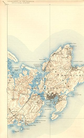
The Annisquam River is a tidal, salt-water estuary in the Annisquam neighborhood of Gloucester, Massachusetts, connecting Annisquam Harbor on the north to Gloucester Harbor on the south. The segment between Gloucester Harbor and the Newburyport/Rockport Line bridge is also known as the Blynman Canal.

Arroyo Corte Madera del Presidio is a 4.1-mile-long (6.6 km) year-round stream in southern Marin County, California, United States. This watercourse is also known as Corte Madera Creek, although the actual stream of that name flows into San Francisco Bay further north at Point San Quentin. This watercourse has a catchment basin of about 8 square miles (21 km2) and drains the south-eastern slopes of Mount Tamalpais and much of the area in and around the town of Mill Valley; this stream discharges to Richardson Bay.

There are two rivers in Idaho named "Lost", the Big Lost River and the Little Lost River. They are often considered separate streams, but both flow into the same depression and become subterranean, feeding the Snake River Aquifer. The rivers are located in Custer County and Butte County, in Idaho in the United States. Via the aquifer and numerous springs, they are tributaries of the Snake River.

The Sol Duc River is a river in the U.S. state of Washington. About 78 miles (126 km) long, it flows west through the northwest part of the Olympic Peninsula, from the Olympic Mountains of Olympic National Park and Olympic National Forest, then through the broad Sol Duc Valley. Near the Pacific Ocean the Sol Duc River joins the Bogachiel River, forming the Quillayute River, which flows about 4 miles (6.4 km) to the Pacific Ocean at La Push. Although the Quillayute River is short, its large tributary rivers—the Sol Duc, Bogachiel, Calawah, and Dickey Rivers—drain the largest watershed of the northern Olympic Peninsula, 629 square miles (1,630 km2). The Sol Duc's watershed is the largest of the Quillayute's tributaries, at 219 square miles (570 km2).
The Elochoman River is a tributary of the Columbia River, in the U.S. state of Washington. It is about 15 miles (24 km) long.
The Palix River is a stream in the U.S. state of Washington. Its tributaries include three forks, North, Middle, and South Fork Palix River, as well as the Canon River. The river's length, including the Canon River, its longest tributary, is approximately 14 miles (23 km).
The North Fork Clearwater River is a major tributary of the Clearwater River in the U.S. state of Idaho. From its headwaters in the Bitterroot Mountains of eastern Idaho, it flows 135 miles (217 km) westward and is dammed by the Dworshak Dam just above its mouth in north-central Idaho. Draining a rugged watershed of 2,462 square miles (6,380 km2), the river has an average flow of over 5,600 cubic feet per second (160 m3/s), accounting for a third of the discharge from the Clearwater basin. The river drains parts of Clearwater, Shoshone, Latah, and Idaho counties. Most of the watershed is managed by the U.S. Forest Service. Some of the fish of the river include westslope cutthroat trout, rainbow trout, mountain whitefish, and the threatened bull trout. It also has smallmouth bass and a kokanee salmon run, both from Dworshak Reservoir. The North Fork drainage is home to grizzly bears, cougars, deer, moose, black bear, elk, grey wolves, and osprey. The river used to have a large steelhead run before the implementation of Dworshak Dam. The North Fork of the Clearwater is located within the Clearwater National Forest
Mon Louis Island, originally known as Isle aux Maraguans, is an island on the coast of the U.S. state of Alabama, south of Mobile. Located in southeastern Mobile County, it has an average elevation of 7 feet (2.1 m). Roughly 2 miles (3.2 km) wide and 6 miles (9.7 km) long, it is bounded by Fowl River on the north and west, Mobile Bay on the east, and the Mississippi Sound on the south. Mon Louis is traversed by Alabama State Route 193, which travels in a north to south direction along the eastern edge of the island. The Gordon Persons Bridge on the southern end of Route 193 connects the island to Dauphin Island. The unincorporated communities of Alabama Port, Heron Bay, and Mon Louis are located on the island.
The Fish River chain of lakes is a series of five lakes in the North Maine Woods region of northern Maine, in a tributary stream to the Fish River. The lakes are an important northern Maine recreation area providing habitat for wildlife including rainbow smelt, brook trout, lake trout, and land-locked Atlantic salmon.
Musquacook Stream is a tributary to the Allagash River in the North Maine Woods. The stream originates in a chain of lakes in Maine range 11 townships 10, 11 and 12. The flow sequence is from Clear Lake through Fifth Musquacook Lake into Fourth Musquacook Lake in Piscataquis County; and from Fourth Musquacook Lake through Third Musquacook Lake, Second Musquacook Lake, and First Musquacook Lake into the Allagash River Musquacook Deadwater in Aroostook County.