Mobile is a city and the county seat of Mobile County, Alabama, United States. The population was 187,041 at the 2020 census. After a successful vote to annex areas west of the city limits in July 2023, Mobile's population increased to 204,689 residents, making it the fourth-most populous city in Alabama, after Montgomery, Birmingham, and Huntsville. Mobile is the principal municipality of the Mobile metropolitan area, a region of 430,197 residents composed of Mobile and Washington counties; it is the third-largest metropolitan area in the state after Birmingham and Huntsville.

Mobile Bay is a shallow inlet of the Gulf of Mexico, lying within the state of Alabama in the United States. Its mouth is formed by the Fort Morgan Peninsula on the eastern side and Dauphin Island, a barrier island on the western side. The Mobile River and Tensaw River empty into the northern end of the bay, making it an estuary. Several smaller rivers also empty into the bay: Dog River, Deer River, and Fowl River on the western side of the bay, and Fish River on the eastern side. Mobile Bay is the fourth-largest estuary in the United States with a discharge of 62,000 cubic feet (1,800 m3) of water per second. Annually, and often several times during the summer months, the fish and crustaceans will swarm the shallow coastline and shore of the bay. This event, appropriately named a jubilee, draws a large crowd because of the abundance of fresh, easily caught seafood.

Dauphin Island is an island town in Mobile County, Alabama, United States, on a barrier island of the same name, in the Gulf of Mexico. It incorporated in 1988. The population was 1,778 at the 2020 census, up from 1,238 at the 2010 census. The town is part of the Mobile metropolitan area. The island was renamed for Louis XIV of France's great-grandson and heir, the dauphin, the future Louis XV of France. The name of the island is often mistaken as Dolphin Island; the word dauphin is French for dolphin, but historically, the term was used as the title of the heir apparent to the French monarch.

In urban planning, the grid plan, grid street plan, or gridiron plan is a type of city plan in which streets run at right angles to each other, forming a grid.

The Cathedral Basilica of the Immaculate Conception is a cathedral serving Roman Catholics in the U.S. city of Mobile, Alabama. It is the seat of the Archbishop of the Roman Catholic Archdiocese of Mobile. The cathedral is named for Mary, mother of Jesus, under her title, Our Lady of the Immaculate Conception. It is listed on the National Register of Historic Places as a contributing property to the Church Street East Historic District and Lower Dauphin Street Historic District and is listed on the Historic Roman Catholic Properties in Mobile Multiple Property Submission
Indian Mound Park, also known as Shell Mound Park or Indian Shell Mound Park, is a park and bird refuge located on the northern shore of Dauphin Island, a barrier island of Mobile County, Alabama in the United States. In addition to the many birds which visit, a wide variety of botanical species contribute to the natural offerings. The site is historically significant due to the presence of prehistoric Indian shell middens, mounds composed of discarded oyster shells. The park was added to the National Register of Historic Places on August 14, 1973. It is administered by the Alabama Department of Conservation and Natural Resources.

Sand Island Light, also known as Sand Island Lighthouse, is a decommissioned lighthouse located at the southernmost point of the state of Alabama, United States, near Dauphin Island, at the mouth of Mobile Bay, Alabama, United States. It is located roughly 3 mi (4.8 km) offshore from the primary Mobile Bay entrance, bounded on the east by Mobile Point and on the west by Dauphin Island. The lighthouse is 132 feet (40 m) high.
The Old Mobile Site was the location of the French settlement La Mobile and the associated Fort Louis de La Louisiane, in the French colony of New France in North America, from 1702 until 1712. The site is located in Le Moyne, Alabama, on the Mobile River in the Mobile-Tensaw River Delta. The settlement served as the capital of French Louisiana from 1702 until 1711, when the capital was relocated to the site of present-day Mobile, Alabama. The settlement was founded and originally governed by Pierre Le Moyne d'Iberville. Upon the death of d'Iberville, the settlement was governed by his younger brother, Jean-Baptiste Le Moyne de Bienville. The site can be considered a French counterpart to the English colonial settlement at Jamestown, Virginia. The settlement site and fort were listed on the National Register of Historic Places on May 6, 1976. The Old Mobile Site was determined eligible for designation as a National Historic Landmark on January 3, 2001.

Bienville Square is a historic city park in the center of downtown Mobile, Alabama. Bienville Square was named for Mobile's founder, Jean-Baptiste Le Moyne, Sieur de Bienville. It takes up the entire block bordered by the streets of Dauphin, Saint Joseph, Saint Francis, and North Conception.
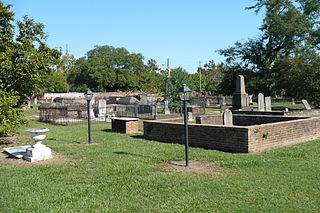
Church Street Graveyard is a historic city cemetery located in Mobile, Alabama. The cemetery is situated on 4 acres (1.6 ha) and is surrounded by a brick wall that dates back to 1830. At the time the cemetery was established, it lay about a half-mile away from most development, but it is now considered to be downtown.
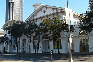
Old City Hall, also known as the Southern Market, is a historic complex of adjoining buildings in Mobile, Alabama, that currently houses the History Museum of Mobile. The complex was built from 1855 to 1857 to serve as a city hall and as a marketplace. It was declared a National Historic Landmark in 1973, as a rare well-preserved example of a 19th-century multifunction civic and commercial building.

The Conde–Charlotte House, also known as the Kirkbride House, is a historic house museum in Mobile, Alabama. The earliest section of the building, the rear kitchen wing, was built in 1822. The main section of the house was added a few decades later and is two and a half floors. The entire structure is constructed of handmade brick with a smooth stucco plaster over the exterior.
The Church Street East Historic District is a historic district in the city of Mobile, Alabama, United States. It was placed on the National Register of Historic Places on 16 December 1971. Since a boundary increase on 13 January 1984, it is roughly bounded by Broad, Conti, Water, Claiborne, and Canal Streets. 20 April 2005 saw the further addition of 66 & 68 Royal Street to the district. The district covers 1,403 acres (5.68 km2) and contains 83 contributing buildings and one object. It contains portions of Mobile's 19th century downtown area and features government, museum, commercial, and residential structures in a variety of 19th-century styles. The buildings range in age from the 1820s to 1900 and include the Federal, Greek Revival, Renaissance Revival, Italianate, and various other Victorian architectural styles. Notable buildings include the Government Street Presbyterian Church, Barton Academy, and the Ketchum House.
The Old Dauphin Way Historic District is a historic district in the city of Mobile, Alabama, United States. It was named for Dauphin Way, now known as Dauphin Street, which bisects the center of the district from east to west. The district is roughly bounded by Broad Street on the east, Springhill Avenue on the north, Government Street on the south, and Houston Avenue on the west. Covering 766 acres (3.10 km2) and containing 1466 contributing buildings, Old Dauphin Way is the largest historic district in Mobile.
The Lower Dauphin Street Historic District is a historic district in the city of Mobile, Alabama, United States. It was placed on the National Register of Historic Places on February 9, 1979. The district encompasses all of Dauphin Street from Water Street to Jefferson Street. It covers 551 acres (2.23 km2) and contains 736 contributing buildings. The boundaries were increased on February 19, 1982, June 30, 1995, August 14, 1998, and September 3, 2019. The buildings range in age from the 1820s to the 20th century and include the Federal, Greek Revival, Queen Anne, Italianate, and various other Victorian architectural styles.

The Campo Santo, also known as Camposanto Monumentale or Camposanto Vecchio, is a historical edifice at the northern edge of the Cathedral Square in Pisa, Italy.

Catholic Cemetery, formerly known as the Stone Street Cemetery, is a historic 150-acre (61 ha) cemetery located in Mobile, Alabama. It was established in 1848 by Michael Portier, a native of Montbrison, France and the first Roman Catholic Bishop of Mobile. The cemetery contains roughly 18,000 burials and has plots dedicated to various Roman Catholic religious institutes, including the Brothers of the Sacred Heart, Daughters of Charity, Little Sisters of the Poor, and Sisters of Mercy. It was placed on the National Register of Historic Places on July 3, 1991, as a part of the Historic Roman Catholic Properties in Mobile Multiple Property Submission.

Ahavas Chesed Cemetery, is a historic Jewish cemetery located in Mobile, Alabama. It was established by the Ahavas Chesed congregation in 1898. It covers about 2 acres (0.81 ha) of land in a narrow strip that adjoins the Sha'arai Shomayim Cemetery.

The RSA Trustmark Building, originally the First National Bank Building, is a 34 story, 424-foot (129 m) International Style office tower located in downtown Mobile, Alabama. Most recently known as the AmSouth Bank Building, it had been named in honor of its largest tenant until 2006, AmSouth Bancorporation. It was renamed the GM Building by its new owner, Retirement Systems of Alabama, in 2009. Following a lease agreement with BancTrust Financial Group and its community bank subsidiary, BankTrust, it was renamed again, this time to the RSA–BankTrust Building. BancTrust Financial Group was purchased in 2013 by Trustmark Corporation, a Mississippi based financial institution. The building officially became the RSA Trustmark Building. Trustmark occupies 72,000 square feet (6,700 m2) of the tower, including the lobby floor and floors 25 through 31.

The Gates–Daves House, also known as The Daves Place, is a historic residence in Mobile, Alabama. The one-story structure was built in 1841 with a Creole architectural influence, the best remaining example of its type in Mobile. It was placed on the National Register of Historic Places on June 20, 1974, due to its architectural significance.