This article may be too long to read and navigate comfortably. Consider splitting content into sub-articles, condensing it, or adding subheadings. Please discuss this issue on the article's talk page.(November 2025)
The 2024 Pacific typhoon season was a below-average season in terms of accumulated cyclone energy (ACE) but was slightly above-average in terms of named storms, typhoons, and super typhoons, ending a four-year streak of below-average seasons that began in 2020. Furthermore, it was the fifth-latest Pacific typhoon season on record, the deadliest season since 2013, and the fourth costliest on record, primarily due to Typhoon Yagi. Moreover, this season saw an unusually active November, with the month experiencing four simultaneously active typhoons and featuring the most retired names in a single season—nine. Of all the 26 named tropical storms, 13 became typhoons and 6 of them reached super typhoon status. The season ran throughout the year, though most tropical cyclones typically develop between May and November. The season's first named storm, Ewiniar, developed on May 25 and eventually intensified into the first typhoon of the season, while the last named storm, Pabuk, dissipated on December 25.
The scope of this article is limited to the Pacific Ocean to the north of the equator between 100°E and 180th meridian. Within the northwestern Pacific Ocean, there are two separate agencies that assign names to tropical cyclones which can often result in a cyclone having two names. The Japan Meteorological Agency(JMA)[nb 2] will name a tropical cyclone if it has 10-minute sustained wind speeds of at least 65km/h (40mph) anywhere in the basin. The Philippine Atmospheric, Geophysical and Astronomical Services Administration(PAGASA) assigns names to tropical cyclones which move into or form as a tropical depression in the Philippine Area of Responsibility (PAR), located between 135°E and 115°E and between 5°N and 25°N, regardless of whether or not a tropical cyclone has already been given a name by the JMA. Tropical depressions that are monitored by the United States' Joint Typhoon Warning Center(JTWC)[nb 3][nb 1] are given a number with a "W" suffix; W meaning west, a reference to the western Pacific region.
During the year, several national meteorological services and scientific agencies forecast how many tropical cyclones, tropical storms, and typhoons will form during a season and/or how many tropical cyclones will affect a particular country. These agencies included the Tropical Storm Risk(TSR) Consortium of University College London, PAGASA, Vietnam's National Center for Hydro-Meteorological Forecasting and Taiwan's Central Weather Administration.
PAGASA released its first outlook on January 15 in their seasonal climate outlook predicting the first half of 2024. They predicted that zero to two tropical cyclones were expected to form, while two to four tropical cyclones are expected to form in April to June.[6] PAGASA also noted that El Niño would persist between January and March; however, warmer than normal sea surface temperatures would gradually weaken.[6]
Tropical Storm Risk (TSR) also released their first forecast on May 7, predicting below average activity with 25 named storms, 15 typhoons and 7 intense typhoons. This was primarily due to the dominant El Niño event at the time, which was expected to transition into a weak or moderate La Niña by mid-2024.[3] TSR released their early July forecast on July 5, where they slightly decreased the amount of storms and typhoons, mentioning the same factors as their previous forecast.[4] On August 7, TSR released their final forecast for the season, retaining the same number of storms. However, they further decreased the predicted ACE index, due to a slow start of the season and decreased tropical activity as of early August.[5] Moreover, with the Pacific Decadal Oscillation being in a negative phase since the beginning of 2020, they also mentioned how this season could become the lowest five-year activity since 1965.[5]
PAGASA released its second and final outlook on June 26, predicting 6-10 tropical cyclones to form between July to September, while 4-7 of those are expected to form between October to December. PAGASA also noted that El Niño conditions had also ended and a transition from neutral ENSO to La Niña is also likely between the former months.[7]
The season began on May 23, when a tropical storm named Ewiniar formed southeast of Palau, marking it as the fifth-latest start of a Pacific typhoon season since reliable records began. It also made Ewiniar the eight-latest time and ended a 157-day period (December 18, 2023 – May 24, 2024) during which no named storm was active in the basin.[8] Ewiniar tracked toward the Philippines, where it was named Aghon by PAGASA, the replacement name for Ambo. Ewiniar made nine landfalls in Homonhon Island; Giporlos, Eastern Samar; Basiao Island; Cagduyong Island; Batuan, Masbate; Masbate City; Torrijos, Marinduque; Lucena, Quezon and Patnanungan. It began to move over the warm tropical waters of Lamon Bay, where both the JTWC and the JMA upgraded Ewiniar into a minimal typhoon. Ewiniar began its extratropical transition while it was 719km (447mi) east-northeast of Kadena Air Base in Okinawa, Japan. On June 6, another extratropical cyclone[which?] would absorb the remnants of Ewiniar, just off the coast of Alaska. On May 30, another tropical depression formed southeast of Haikou, China. The next day, at 03:00 UTC, JTWC designated the disturbance as Tropical Depression 02W. A few hours later, JMA assigned the name Maliksi to 02W as it was designated as a tropical storm. Shortly thereafter, on May 31, Maliksi made landfall in Yangjiang, Guangdong. The JMA and JTWC discontinued warnings as Maliksi moved inland and dissipated on June 2. No storms formed in June for the first time since 2010.
Satellite loop of Typhoon Gaemi skirting the coast before making landfall in the northeastern coast of Taiwan on July 24
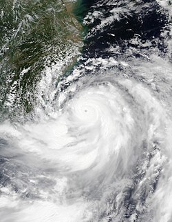
After many weeks of inactivity, on July 13, a tropical depression formed east of Vietnam, designated as 03W. Shortly after, it tracked into Vietnam, dissipating soon after. On July 19, two tropical disturbances were recognized by the JTWC: one southeast of Manila and another east of Palau. Soon after, both disturbances developed into a depression, being named by PAGASA. The first one, west of Batangas, was named Butchoy while the second, east of Virac, was named Carina. Later that day, the JTWC followed suit, designating both as tropical depressions, with Butchoy being 04W and Carina as 05W. The next day, the more eastern disturbance, Carina, was named Gaemi by the JMA. On July 21, Butchoy also intensified into a tropical storm, receiving the name Prapiroon from the JMA. Prapiroon moved through the South China Sea as a mild tropical storm before making landfall over Wanning, Hainan. Prapiroon moved through Gulf of Tonkin, where it further intensified into a severe tropical storm. Early on July 23, Prapiroon made its second and final landfall in Quảng Ninh, Vietnam.
Situated in a favorable environment in the Philippine Sea, Gaemi continued to strengthen and became the second typhoon of this season. Gaemi rapidly intensified into a very strong typhoon, with 10-minute sustained winds of 165km/h (105mph). Gaemi stalled and executed a counterclockwise loop near the coast, slightly weakening before making landfall over the northeastern coast of Taiwan. Weakened by the landfalls, the storm accelerated across the island and emerged into the Taiwan Strait, six hours after landfall. The next day, Gaemi made its final landfall at Xiuyu, Putian in Fujian Province as a weakening tropical storm. Moving inland, the storm rapidly weakened until it dissipated on July 27.
Even though Gaemi never made landfall in the Philippines, the storm's moisture would enhance the southwest monsoon. Heavy rainfalls were felt over Luzon and some parts of the Visayas, leaving the regions flooded. Overall, Gaemi caused 152 fatalities and US$4.57billion worth of damages throughout its track.
Peak season activity
Four systems active on August 13: Tropical Depression Maria (top left); Tropical Storm Ampil (bottom left); Tropical Depression Son-Tinh (center right); and Tropical Depression 09W (bottom right; precursor to Wukong).
On August 3, a low-pressure area developed east of Kadena Air Base. At 00:00 UTC, JMA recognize the disturbance as a depression. However, it was downgraded to a remnant low on August 7. The convection later meandered south of Ryukyu Islands for a few days before JMA reclassified it again as a depression on August 11. JMA issued a gale warning the next day, citing that it would intensify in the following days. JTWC later followed suit and upgraded it into Tropical Depression 08W. On August 13, the depression became a tropical storm, receiving the name Ampil from the JMA. Ampil gradually intensified in the Pacific Ocean, becoming a severe tropical storm. JMA upgraded Ampil into a typhoon two days later, and the JTWC classified it as a Category2-equivalent typhoon. The next day, it strengthened into a Category4-equivalent typhoon. The typhoon passed just south of Greater Tokyo Area before weakening and transitioning to an extratropical cyclone.
On August 5, a low-pressure area formed in Bonin Islands. The disturbance was in an environment with low to moderate wind shear and warm SSTs. The JTWC later classified the disturbance as a depression the next day, giving it the designation 06W. Early on August 8, JMA upgraded the depression into a storm, naming it Maria. The storm further strengthened into a severe tropical storm on the same day. At the same time, JTWC reported that Maria had rapidly intensified into a typhoon due to strong equatorward and poleward outflow. However, on August 9, Maria weakened into a tropical storm as it moved northeastward. On August 10, another low-pressure area formed just southeast of Maria. The JTWC would classify the disturbance as a subtropical depression in their next bulletin. Despite being in a marginal environment and high wind shear, JMA upgraded into a tropical storm, giving it the name Son-Tinh. The next day, JTWC reported that Son-Tinh became tropical, designating it as 07W. Son-Tinh weakened back into a tropical depression before dissipating on August 14.
On the morning of August 12, Maria made landfall in Iwate Prefecture as a tropical storm, bringing strong winds and heavy rains in northern Japan. After moving inland, Maria weakened into a tropical depression. The storm entered the Sea of Japan, further weakening on the next day. The JTWC issued its final warning after Maria was last noted west-northwest of Misawa. JMA continued to track the depression before they issued their final warning at 04:15 UTC.
Activity increased when an area of convection was formed on August 12 near the southwest of Son-Tinh. JMA would immediately recognize the disturbance as a tropical depression. The next day, JTWC went on classifying it as a tropical depression, designating it 09W. Similar to Ampil, on August 13, 09W intensified into a tropical storm, receiving the name Wukong from the JMA. Wukong was short-lived due to its poorly organized cloud tops. JTWC made its final warning for Wukong as it moved through cooler waters and dissipated on August 15.
On August 17, JMA recognized a tropical depression that formed east of Taiwan. The next day, PAGASA declared the system a tropical depression, naming it Dindo. The depression was named Jongdari by the JMA three hours later upon intensification to a tropical storm. JTWC later followed suit and upgraded Jongdari into a tropical storm, with the designation of 10W. However, it did not last long and weakened into a tropical depression while nearing the Korean Peninsula. On August 21, JMA and JTWC reported that Jongdari had dissipated as its low-level circulation center faded when it moved over land. After Jongdari, a low-pressure area formed in the Northern Mariana Islands on the same day. The system intensified into a tropical storm the next day, with the JMA naming it Shanshan. JTWC then gave Shanshan the designation 11W.
Shanshan later strengthened into a Category1-equivalent typhoon. It remained at that intensity as it battled through wind shear. As it went near the Amami Islands, it strengthened into a Category4-equivalent typhoon. The approach of the typhoon caused the issuance of a special warning system in Kagoshima Prefecture, the first time in the area since Typhoon Nanmadol in 2022. Around 08:00 JST on August 29, Shanshan made landfall near Satsumasendai, making it the third tropical cyclone impacting mainland Japan this season. Rapid erosion later ensued as it moved eastward while inland. Shanshan heads over Seto Inland Sea before it makes another landfall in Shikoku on the next day. Shanshan's convection began to be disorganized, causing it to weaken into a remnant low. However, it strengthened back into a tropical depression as it moved east-southeastward through open waters. JMA continued to track Shanshan until it dissipated on September 1.
Typhoon Yagi making landfall over Wenchang City in Hainan on September 6
On August 30, a tropical disturbance formed near Palau. On the same day, JMA started to issue advisories for the system as a depression. As it entered the Philippine Area of Responsibility (PAR), the PAGASA named it Enteng on September 1. JTWC followed suit, and Enteng was classified as a tropical depression, with the designation 12W. At 21:00 JST (13:00 UTC), JMA classified Enteng as a tropical storm, naming the system Yagi. The storm made its first landfall in Casiguran in Aurora Province at 14:00 PHT on September 2. The mountainous terrain of the Cordillera Central made Yagi weaken as it moved inland. It exited the PAR early on September 4 as it continues to intensify in the South China Sea.
Entering the South China Sea, Yagi later strengthened into a typhoon due to its highly favorable environmental conditions. The following day, it rapidly intensified, developing a distinct eye and briefly reaching Category 5-equivalent super typhoon status at 00:00 UTC on September 5 as it approached Hainan. The whole cloud system of Yagi covered the entire South China Sea. Yagi slightly weakened before it made its second landfall over Wenchang City in Hainan. The storm then moved over Haikou, and continued to make another landfall in Xuwen County, Guangdong. Afterward, Yagi entered the open waters of the Gulf of Tonkin.
Yagi became one of only the four Category5 typhoons recorded in the South China Sea, alongside Pamela in 1954, Rammasun in 2014, and Rai in 2021. It also marked the most powerful typhoon to strike Hainan in autumn since Typhoon Rammasun. On September 7, Yagi underwent a period of reorganization and regained Category4 status before making a historic landfall between Haiphong and Quảng Ninh in Vietnam. Upon landfall, Yagi became the strongest storm in history to impact Northern Vietnam. The typhoon then rapidly weakened as it moved inland, becoming a tropical depression on September 8. The JMA continued monitoring the system before reporting that Yagi dissipated at 18:00 UTC on the next day. Even after dissipation, it still wreaked havoc, bringing heavy floods to Myanmar, Laos, and Thailand.
While Yagi was still on its way to making landfall in the Philippines, JTWC announced another formation of a tropical disturbance in the open Pacific Ocean on September 2. JMA also started issuing advisories, and it was recognized as a tropical depression in the same location. Two days later, as JTWC also upgraded it into a tropical depression, it received its designation, 13W. The day after, JMA reported that 13W developed into a tropical storm, giving it the name Leepi as the twelfth named storm of this season. Leepi then accelerated northeastwards before it became an extratropical cyclone on September 6.
On September 9, a tropical depression formed over the Micronesian Islands. The following day, the JTWC designated it as 14W. As it moved over Guam, 14W intensified into a tropical storm and was named Bebinca by the JMA. Despite encountering dry air, Bebinca still strengthened as it began its northwestward movement. At 18:00 PHT on September 13, Bebinca entered the Philippine Area of Responsibility and was named Ferdie by PAGASA. Bebinca later strengthened into a minimal typhoon on the next day. On September 16, Bebinca made landfall in Lingang New City in Shanghai as a weakening Category1 typhoon. Bebinca became the strongest typhoon to hit Shanghai since Typhoon Gloria in 1949.
As Bebinca moved toward eastern China, two tropical depressions formed in the Pacific on September 15—one near Guam and another within the Philippine Area of Responsibility (PAR). The JTWC designated the depression near Guam as 15W. It soon intensified into a tropical storm and was named Pulasan by the JMA. The other tropical depression, being in the PAR, was given the name Gener by the PAGASA. At 02:00 PHT on September 16, Gener made landfall over Palanan, Isabela. The storm continued to move westward over Northern Luzon, maintaining its strength as a tropical depression. Meanwhile, Pulasan briefly entered the PAR at 18:30 PHT (10:30 UTC) and was given the name Helen. On September 18, two disturbances in the South China Sea, Invests 98W and 99W were expected to merge and strengthen as 98W, closer to Vietnam. Shortly after, Gener was upgraded into a tropical depression by the JTWC, getting the designation 16W. On September 19, 16W was upgraded to a tropical storm and named Soulik by the JMA. Soulik made landfall over Vĩnh Linh District, Quảng Trị Province in Vietnam. Meanwhile, Pulasan also made landfall over Zhoushan, China, similar to where Bebinca had made landfall three days earlier. After that, it made a second landfall over Shanghai, marking the first time since reliable meteorological records exist that two typhoons make landfall over Shanghai with only two days in between.
On September 20, a low-pressure area formed over Northern Luzon. The JTWC later designated the disturbance as Invest 90W upon its formation. As it was inside the PAR, PAGASA initiated advisories and named the system Igme. The JTWC soon upgraded it into a tropical depression, designating it as 17W. Igme later curved southwestwards, passing closely to Taiwan. The storm later dissipated on September 22 after topographical interaction, and high vertical wind shear had significantly weakened the system.
Two days later, on September 24, a tropical depression formed in the Pacific south of Japan. That day, JTWC designated the system as 18W. The following day, the JMA upgraded the depression into a tropical storm, assigning it the name Cimaron. The storm moved southwestwards, maintaining its intensity. As it moved westwards, Cimaron weakened into a tropical depression as an unfavorable environment hindered any intensification. Cimaron later dissipated on September 27. Shortly later the same day, another low-pressure area formed near the Northern Mariana Islands. Despite being in a marginal environment, the disturbance managed to organize and was designated as 19W by the JTWC. On September 27, the JMA upgraded 19W into a tropical storm, naming it Jebi. At first, Jebi struggled to organize due to the presence of moderate low-level wind shear, causing Jebi to weaken into a tropical depression. However, Jebi redeveloped back into a tropical storm after. The storm continued to organize until it further intensified into a Category1 typhoon by the JTWC, while according to the JMA, it only reached the intensity of a severe tropical storm. Jebi later transitioned to an extratropical cyclone, and both agencies issued their final warning on October 2.
Shortly after Cimaron weakened into a tropical depression, a low-pressure area formed in the Philippine Sea near extreme northern Luzon on September 26. The PAGASA started issuing bulletins regarding the disturbance and was named Julian as it strengthened into a tropical depression. The following day, the JTWC designated Julian as 20W, also upgrading it into a tropical depression. On September 28, the JMA upgraded 20W into a tropical storm, naming it Krathon, a replacement name for Mangkhut. It then intensified into a Category1 typhoon, heading towards Sabtang, Batanes. Shortly after, the typhoon began its rapid intensification and in two days, the system reached its peak intensity equivalent to a Category4 super typhoon. On October 3, Krathon made landfall over Siaogang District in Kaohsiung, Taiwan. The typhoon became the first storm to make landfall in Taiwan's densely populated western plains since Typhoon Thelma in 1977. The storm weakened while moving inland, marking the first time this had happened in Taiwan since Tropical Storm Trami in 2001. The JMA continued to track the system to the South China Sea before it dissipated on October 4.
Late season activity
On October 5, a tropical depression formed near Guam. The following day, the JTWC designated it as 21W. Despite moving through warm waters, high wind shear hindered any further development, causing it to weaken back into a disturbance. On October 8, the JTWC issued its final warning, with dissipation expected in the next 12 hours. The next day, 21W intensified into a tropical storm, receiving the name Barijat from the JMA. Later in the day, JTWC reissued advisories on Barijat and strengthened into a tropical storm. However, both agencies later made their final warning for the last time as the storm dissipated on October 11.
An aerial view of the flooded rice fields in Camarines Sur after the onslaught of Trami
On October 19, a tropical depression formed nearby Yap. The next day, it was assigned as 22W by the JTWC. Then, it moved into the PAR and was named Kristine by the PAGASA. Soon after, the JMA upgraded it to a tropical storm and was given the name Trami. Many parts of the Philippines were issued wind storm signals prior to its approach to the country. On October 23, Trami strengthened into a severe tropical storm, prompting the upgrade to Tropical Cyclone Wind Signal No.3 in parts of northern and central Luzon. At 04:30 UTC on October 24, Trami made landfall over the province of Divilacan, Isabela. The following day, Trami emerged above the coastal waters of southern Ilocos Sur, leaving the remnants of a circulation center over northern Luzon. This caused torrential rains and gusty winds throughout the day in many areas of the country.
Trami continued crossing the South China Sea while maintaining severe tropical storm strength. As it approached the coast of Vietnam, the storm encountered strong easterly vertical wind shear. It made landfall in Da Nang at 10:00 ICT on October 27. Trami then drifted southwestward due to weak steering flow and later made a U-turn over Vietnam's coastal regions. The storm eventually weakened into a low-pressure area, with agencies issuing their final warning on October 29.
Kong-rey making landfall in Chenggong, Taitung in eastern Taiwan on October 31
As Trami crossed the Cordillera Central, another tropical disturbance developed southeast of Guam on October 24. The JMA began monitoring the system as a tropical depression and issued a gale warning. On the following day, the JMA upgraded the disturbance to a tropical storm, naming it Kong-rey. At the same time, another disturbance designated as Invest 99W formed to the north. As a result, the JTWC cancelled warnings for the southern system (Invest 98W) and reclassified Kong-rey under 99W. The JTWC later designated the system as Tropical Depression 23W. The storm then entered the PAR, where it received the local name Leon. On October 29, Kong-rey started undergoing rapid intensification and became a Category4-equivalent super typhoon the following day. With that, Kong-rey achieved a peak intensify of 1-minute sustained winds of 240km/h (150mph) and a minimum central pressure of 925hPa (27.32inHg).
Shortly after reaching its peak intensity, Kong-rey started to slightly weaken while undergoing an eyewall replacement cycle as it tracked northwestward. The typhoon later made a historic landfall over Chenggong, Taitung in Taiwan, marking the first major typhoon to strike the island after mid-October and the most powerful since Typhoon Herb in 1996. Kong-rey then emerged through the Taiwan Strait with a weakened convective structure around the center. It continued to weaken and transitioned to an extratropical cyclone over Sasebo, Japan, prompting both agencies to issue their final advisories on November 1.
Four systems active on November 11: Tropical Storm Yinxing [Marce] (far left); Severe Tropical Storm Toraji [Nika] (upper left); Tropical Storm Usagi [Ofel] (center right); and Tropical Storm Man-yi [Pepito] (far right)
Shortly after Kong-rey transitioned to a post-tropical cyclone, an area of low pressure formed near Palau on November 1. Initially, the JTWC ceased issuing advisories due to unfavorable environmental conditions. However, as the system began to show increased organization two days later, the JTWC resumed advisories. At 14:00 UTC on November 3, both the JTWC and the JMA upgraded the system to a tropical depression, with the former assigning it the designation 24W. Later that day, at 18:00 UTC, it intensified into a tropical storm and was named Yinxing by the JMA, the replacement name for Yutu. Upon entering the PAR, Yinxing received the local name Marce from the PAGASA. It continued to intensify over the Philippine Sea, prompting both agencies to classify it as a typhoon the following day. It then reached its peak intensity of a Category4-equivalent typhoon, with 1-minute sustained winds of 230km/h (145mph) and a minimum central pressure of 940hPa (27.76inHg). At around 15:40 PHT (07:40 UTC) on November 7, Yinxing made landfall over Santa Ana, Cagayan. After traversing the Babuyan Channel in the Luzon Strait, it made its second landfall over Sanchez Mira, Cagayan. The storm slightly weakened into a Category2-equivalent typhoon after making landfall, but later reintensified as a Category3-equivalent typhoon on November 9 as it moved into the South China Sea. On November 10, Yinxing was steadily weakening, with its CDO becoming more asymmetric as it encountered cooler sea surface temperatures and increasing vertical wind shear. The storm moved southwestward between two mid-level subtropical ridges, and its convective structure became increasingly asymmetric. Strong southwesterly shear disrupted the central dense overcast and exposed the low-level circulation, prompting the JMA to downgrade the system to a tropical storm at 00:00 UTC. Despite maintaining a compact circulation with an eye-like feature near the southern coast of Vietnam, convection remained disorganized. At 07:00 UTC on November 12, Yinxing made landfall just north of Quy Nhơn. The JTWC issued its final warning shortly after landfall, with the JMA continuing to monitor the system until it dissipated inland at 18:00 UTC the same day.
On November 8, a tropical disturbance developed east of Southern Luzon and began moving westward in a favorable environment. At 08:00 PHT (00:00 UTC) on the following day, the system entered the PAR and was assigned the name Nika by the PAGASA. Shortly afterward, another area of low pressure formed near the Marshall Islands and was designated as Invest 93W. With favorable conditions and low vertical wind shear, the JTWC issued a Tropical Cyclone Formation Alert (TCFA) for the system. Later that day, both 93W and Nika were upgraded to tropical depressions, with the systems designated as 25W and 26W respectively.
Later that day, both systems intensified into tropical storms and were named Man-yi and Toraji by the JMA. On November 10, Toraji continued to strengthen and was upgraded to a severe tropical storm by the JMA, while the JTWC classified it as a Category1 typhoon as its outer bands became more organized. The JMA subsequently upgraded Toraji to typhoon status before it made landfall in Dilasag, Aurora. The system then exited into the South China Sea near Magsingal, Ilocos Sur, with satellite imagery showing a compact and tightly wrapped low-level circulation. As Toraji moved northwestward, its low-level circular convection weakened over the center, and the storm was downgraded to a tropical storm on November 11. Satellite imagery later showed a weakening of deep convection at its center, with low-level cloud banding visible around the center and along the southern edge of the circulation. This was attributed to strong southerly vertical wind shear as the system became embedded in the low-level northeasterly flow associated with a cold surge. As a result of convective decapitation that left the low-level circulation fully exposed, the JTWC issued its final advisory on November 14, downgrading the system to a tropical depression. The JMA continued monitoring the system until it was last noted at 06:00 UTC on November 15.
Meanwhile, on November 9, a tropical depression formed near Micronesia. The following day, the JMA began issuing warnings on the system. On November 11, the JTWC upgraded it into a tropical depression, designating it as 27W. By early morning of the next day, 27W intensified into a tropical storm, prompting the JMA to assign the name Usagi. This marks the first time in reliable meteorological records that four active systems were active simultaneously in the basin during November.[9] Around the same time, Usagi entered the PAR, receiving the local name Ofel from PAGASA. The storm continued to intensify and underwent a period of rapid intensification, reaching Category4-equivalent super typhoon strength on November 14. At 13:30 PHT (05:30 UTC) of the same day, Usagi made landfall over Baggao, Cagayan. After landfall, Usagi began to weaken as its eye became obscured due to interaction with mountainous terrain. After crossing northern Luzon, it emerged into the Babuyan Channel, moving northwestward along the edge of a mid-level subtropical high. The system passed near the Babuyan Islands and northern Cagayan, prompting the JMA to downgrade it to a severe tropical storm. Satellite imagery showed a weakening low-level circulation with convection displaced northeast of a partially exposed center. As Usagi drifted southwest of Taiwan, it continued to weaken due to strong vertical wind shear, leading the JTWC to issue its final warning on November 16. The JMA monitored the system until it dissipated at 12:00 UTC on the same day.
Upon being named Usagi as 27W, the Western Pacific basin experienced a rare meteorological occurrence on November 12: two typhoons were active in the South China Sea simultaneously for the first time since Angela in 1992. It also marked the first time since records began in 1951 that four tropical cyclones were simultaneously active in November, and the first time in the basin since 1970.
Meanwhile, after maintaining tropical storm strength for five days, the JMA upgraded Man-yi to a severe tropical storm as it entered a more favorable environment. At 20:00 PHT (12:00 UTC) on November 14, the storm entered the PAR, where it was given the name Pepito by the PAGASA. By early on November 16, Man-yi had rapidly intensified and peaked as a super typhoon, with estimated 1-minute maximum sustained winds of 260km/h (160mph) and a central pressure of 920hPa (27.1inHg). At 21:40 PHT (13:40 UTC), Man-yi made its first landfall over Panganiban, Catanduanes, bringing destructive winds and torrential rain. The following day, it made a second landfall in Dipaculao, Aurora in Luzon at around 15:20 PHT (07:20 UTC).,[10] with the Sierra Madre mountain range disrupting its structure and causing the eye to collapse. Man-yi then accelerated northwestward into the South China Sea, weakening into a severe tropical storm as vertical wind shear increased. The JTWC issued its final warning on November 19 as Man-yi weakened into a tropical depression, while the JMA continued monitoring the system until it was last noted at 06:00 UTC on November 20.
After several weeks of inactivity, a low-pressure area developed southeast of Mindanao on December 17. The following day, the disturbance entered the PAR, where it was classified as a tropical depression and assigned the name Querubin by PAGASA, replacing the retired name Quinta. Despite favorable environmental conditions, Querubin struggled to organize due to its proximity to land, which hindered development. The JTWC issued two TCFAs, citing a high probability of intensification. However, as Querubin crossed between the Visayas and Mindanao, PAGASA issued its final advisory on December 18, declaring it a well-marked low-pressure area. The JTWC continued to monitor the system, though downgraded it to a low chance of development, before ceasing bulletins the following day.
The final tropical cyclone of 2024 developed on December 20 over northeast Malaysia and was designated as Invest 98W. The system brought gusty winds across Sarawak, Sabah, and Brunei throughout its formation. The next day, the JTWC issued a TCFA, citing high chances of development. However, the emergence of a nearby disturbance, designated Invest 99W, led the JTWC to lower the development potential of 98W and shift focus to the new system. Despite remaining outside the PAR, the PAGASA named the disturbance Romina, replacing the retired name Rolly due to its potential impact on the Kalayaan Islands. This marked the first time that PAGASA has assigned a local name to a system outside the PAR since 1963. The JTWC later designated Romina as 28W, and the JMA subsequently upgraded it to a tropical storm, assigning the international name Pabuk. The storm tracked westward before turning toward Vietnam, weakening into a tropical depression as it encountered strong low-level northeasterly flow associated with a cold surge. The final advisory on Pabuk was issued at 18:00 UTC on December 25 as it degenerated into a well-marked low-pressure area.
Typhoon Ewiniar resulted in ₱1.03 billion(US$20.88 million) in total damages in the Philippines, with ₱85.63 million(US$1.74 million) to agriculture and ₱942.55 million(US$19.14 million) to infrastructure, while also causing six deaths, injuring eight people, and impacting around 152,266 others. In Japan, heavy rainfall was observed in several regions, with a maximum of 52.5mm (2.07in) of rain being recorded in Miyake, Tokyo.[19][20]
On May 29, the JTWC began tracking an area of convection located 406km (252mi) southeast of Haikou, China. Being in an area of warm waters and low vertical shear and having southerly outflow, the system sustained a weak circulation, inhibited from development by another area of convection near Mainland China.[21] It was recognized as a low-pressure area by the Japan Meteorological Agency (JMA) early the next day,[22] before the agency upgraded it to a tropical depression at 06:00 UTC.[23] Later that day, the JTWC issued a Tropical Cyclone Formation Alert (TCFA) on the depression since it had rapidly developed.[24] At 00:00 UTC the next day, the JTWC upgraded the system into a tropical depression, designating it as 02W.[25] Later, the JMA upgraded it into a tropical storm, and it was given the name Maliksi.[26] However, the JTWC reported that it did not intensify into a tropical storm as it was disorganized, with the circulation elongating.[27][28] At 21:00 UTC on May 31, the JTWC discontinued warnings on the system as it made landfall in Yangjiang, Guangdong.[29] Soon after, the JMA last noted Maliksi as a depression on June 1 before weakening further into a low-pressure area the next day, as it tracked inland.[30][31][32]
On July 13, the JTWC began tracking an area of convection 423mi (682km) east-southeast of Da Nang, Vietnam. At the time, the disturbance was in a marginal environment for development, with high vertical wind shear offsetting good divergence aloft alongside warm sea surface temperatures.[39] At 06:00UTC of that day, the JMA designated the system as a tropical depression.[40] The JTWC then issued a TCFA on the system the next day, noting its symmetrical center had improved as it moves northwest, though convection was disorganized.[41] By 18:00UTC the next day, the JTWC upgraded the system into a tropical depression, designating it 03W.[42] However, they issued their last warning on the depression early the next day as it moved over Vietnam and rapidly weakened.[43] Later that day, the JMA stopped tracking the depression as it dissipated.[44]
On July 17, the JMA reported that a low-pressure area had formed east of Palau.[44] Shortly after, both the JMA and the JTWC followed suit and upgraded the tropical depression,[44] with the latter designating the system as 05W.[45] The PAGASA followed suit a few hours later, recognizing the system as a tropical depression and naming it Carina.[46] Early the next day, the depression intensified into a tropical storm, and was given the name Gaemi by the JMA.[47] Due to a weak steering environment between the subtropical ridge to the northwest and east, the JTWC upgraded Gaemi to minimal typhoon around 21:00 UTC that day.[48] On July 24, Gaemi later rapidly intensified and peaked at Category 4-equivalent intensity on the Saffir-Simpson scale at 21:00 UTC on 23 July, with 1-minute sustained winds of 230km/h (145mph) by the JTWC, 10-minute sustained winds of 165km/h (105mph) by the JMA, and a central pressure of 935hPa (27.61inHg).[49][47] After stalling and executing a tight counter-clockwise loop near the coast,[50] Gaemi slightly weakened into a below-equivalent typhoon status due to land interaction before it made landfall on the northeastern coast of Taiwan on July 24.[51] Gaemi accelerated as it moved across the island and emerged into the Taiwan Strait just six hours after making landfall.[52] Soon after,[53] the JTWC ceased issuing advisories on the system as it made its final landfall at Xiuyu, Putian in Fujian Province.[54] Once inland, the JMA downgraded Gaemi into a tropical depression on July 26[47] and continued tracking the system until it dissipated at 18:00UTC of July 29.[32]
The southwest monsoon, combined with Tropical Storm Prapiroon, brought heavy rains to southern and northern Luzon, triggering widespread flash floods that resulted in at least 126 deaths and caused damage estimated at US$2.31 billion across several countries.[55][56][57]
On July 15, the JTWC started to monitor a persistent area of convection roughly 623km (385mi) southeast of Manila, Philippines. At that time, the disturbance was in a favorable environment for development, with warm 29–30°C (84–86°F), sea surface temperatures, low wind shear and good equatorial outflow.[58] At 06:00UTC the same day, the JMA designated the system as a low-pressure area.[44] Shortly after, the JMA designated it as a tropical depression.[44] The PAGASA declared the system a tropical depression a few hours later. Since the storm formed within the Philippine Area of Responsibility, the agency named it Butchoy.[59] The JTWC began issuing advisories on the system, classifying it as 04W.[60] It intensified into a tropical storm and was named Prapiroon by the JMA on July 21.[61][62] The center of Prapiroon made landfall near Wanning, Hainan, with 1-minute sustained winds of 95km/h (60mph) on July 22.[63] After making landfall, the storm maintained its well-defined eye while moving across central Hainan.[64] Prapiroon soon encountered high wind shear and a dry environment,[65] and by 6:30a.m. local time on July 23, it made its second landfall in Quảng Ninh, Vietnam.[66][67] After the system moved inland, both the JMA and the JTWC ceased monitoring it on July 24.[44][68]
Typhoon Gaemi and Prapiroon, along with its precursor, significantly impacted the southwest monsoon over the Philippines, leading to heavy rainfall that caused 23 deaths, 9 people missing, and US$32.9million in damages across several countries.[69][70][71]
On August 5, the JMA stated that a tropical depression had formed.[44] Later that day, the JTWC began tracking it, noting the depression was in an environment with low to moderate wind shear, warm sea surface temperatures, and good equatorward outflow aloft.[72] At 09:00UTC on August 6, the JTWC issued a TCFA on the disturbance, which was located 423mi (682km) north-northwest of Iwo Jima, along the eastern periphery of the monsoon gyre,[73] prior to it being designated as 06W.[74] The development of a central dense overcast and a ragged eye feature signified its intensification into a tropical storm,[75] leading the JMA to name it Maria on August 7.[76] Maria then turned northeastward,[47] and intensified into a severe tropical storm on August 8 due to a favorable environment for development.[47] Concurrently, the JTWC then reported that Maria had rapidly intensified into a minimal typhoon due to strong equatorward and poleward outflow.[77] However, Maria's wind field became more asymmetric, with its associated convection shifting northward,[78] causing Maria to weaken into a tropical storm on August 9.[79] Around 00:00 UTC on August 12, the storm made landfall Ōfunato,[80] a city in Iwate Prefecture, Japan with winds of 85km/h (50mph) before traversing northern Honshu and emerging into the Sea of Japan.[81] The JMA continued to monitor the system until it was last noted at 18:00 UTC on August 14.[44]
Record-breaking rainfall in Iwate Prefecture, with 19 inches (482.6mm) in Kuji and 12.6 inches (320.0mm) in Otsuchi—nearly double the average for August—led to controlled releases from the Taki Dam in Kuji, necessitating the evacuation of 8,300 people and the issuance of the highest evacuation alert level, though no damage or injuries were reported in association with Maria.[82]
On August 10, the JMA noted that a tropical depression had formed southeast of Severe Tropical Storm Maria.[47] A few hours later, the JTWC began tracking the system, noting that it could transition into a tropical cyclone despite intense wind shear.[83] Early the next day, they noted that the depression had transitioned into a subtropical cyclone.[84] As a result, a few hours later, the JMA named it Son-Tinh.[47] The next day, the JTWC noted that it had transitioned into a tropical storm, designating it 07W.[85] Soon after, the low-level circulation center became fully exposed with no deep convection existing near the center.[86] On August 13, Son-Tinh turned northwest along the western edge of a subtropical ridge.[87] Both the JMA and the JTWC stopped monitoring it as a tropical depression that day,[47] though the JMA continued to track it until it was last noted the following day.[44]
On August 3, the JTWC began tracking an area of convection 976km (606mi) east of Kadena Air Base on August 3.[88] At 18:00UTC the same day, the JMA designated the system as a low-pressure area.[44] However, the following day, the system was upgraded to a tropical depression.[44] The depression weakened and was last noted by the JMA on August 7.[44] The disturbance later meandered south of the Ryukyu Islands for a few days before it was re-designated by the JMA as a tropical depression on August 11.[44] A few hours later, they recognized the system as a tropical depression, designating it as 08W.[89] Soon after, the JMA noted that it had intensified into a tropical storm and named it Ampil.[47] The JMA then reported that Ampil had intensified into a typhoon due to warm sea surface temperatures and low vertical wind shear on August 15.[47] The JMA reported that Ampil reached its peak intensity at 12:00 UTC that day with 10-minute sustained winds of 155km/h (100mph) and a central pressure of 950hPa (28.05inHg) before making its closest approach to Japan, and transitioned into an extratropical low on August 19.[47]
Ampil brought strong winds and coastal waves to western Alaska, while Tokyo experienced minimal damage according to NHK, although Kanagawa Prefecture saw several injuries; the remnants of Ampil also contributed to an atmospheric river as its moist core flowed into a low-pressure system, ultimately being absorbed into the Pacific jet stream and anticipated to impact California.[90]
On 12 August, the JMA noted that a tropical depression formed southwest of Tropical Storm Son-Tinh.[44] A few hours later, strong convection south of the system's low-level circulation center consolidated, which prompted the JTWC to issue a TCFA for the disturbance.[91] Soon after, they recognized the system as a tropical depression, designating it as 09W.[92] Satellite imagery revealed that a central dense overcast obscured the center, leading to the depression strengthening into a tropical storm named Wukong by the JMA,[93] although moderate vertical wind shear displaced the deep convection to the southeast.[94][47] Wukong then shifted northwestward, following the eastern edge of a subtropical ridge, while also being affected by the shear and outflow from Typhoon Ampil to the southwest.[95] On August 15, both the JMA and the JTWC ceased monitoring the system, with the JMA reporting that Wukong had transitioned into an extratropical low due to moderate vertical wind shear and cooler sea surface temperatures.[96][47]
On August 17, a low-pressure area east of Taiwan developed into a tropical depression.[44] Soon after the development of a low-level circulation center and deep convection, the JTWC issued a TCFA for the disturbance.[97] A few hours later, PAGASA declared the system a tropical depression and named it Dindo,[98] while the JMA reported it had intensified into a tropical storm and named it Jongdari,[47] and the following day, the JTWC recognized it and designated it as 10W.[99] Jongdari became devoid of convection as it was displaced from its exposed low-level circulation center and turned north-northeastward along the western edge of a subtropical ridge.[100] Jongdari then weakened as it moved into the Yellow Sea and made landfall over the Korean Demilitarized Zone on August 20 before emerging into the Sea of Japan.[44][101] The JTWC assessed the cyclone as having dissipated and ceased issuing advisories on the system,[102] while the JMA continued to monitor the system until it was last noted on August 21.[44]
In some parts of the southern islands of Jeju, Jongdari accumulated 60–130 millimetres (2.4–5.1in) of rain as it moved closer to the coast.[103] One person was killed as a result of Jongdari, when a 60-year-old man drowned in a port located on Heuksando, Sinan County. He was a 43-ton fishing boat crew member that docked in the port to seek refuge from the storm.[104]
The remnants of Jongdari caused heavy rain and triggered flooding in Liaoning, China. 27 people were dead or missing, total damage reached 15.47 billion yuan (US$2.15 billion).[105]
On August 20, the JMA reported that a low-pressure area had formed near the Mariana Islands.[106] At midnight on August 21, both the JMA and the JTWC upgraded the tropical depression, with the latter designating the system as 11W.[107][108] Shortly after, the depression intensified into a tropical storm and was named Shanshan by the JMA due to low vertical wind shear and warm sea surface temperatures.[107] A ragged eye-like feature appeared on satellite imagery, and on August 24,[47] both the JMA and the JTWC upgraded it to a minimal typhoon.[109] The JMA reported that Shanshan reached its peak intensity at 15:00 UTC on August 27, with 10-minute sustained winds of 175km/h (110mph) and a central pressure of 935hPa (27.61inHg).[107] Shanshan then turned northward and made landfall near Satsumasendai in Kagoshima Prefecture on August 29.[107][110] It then turned eastward along the northern periphery of a subtropical high,[111] quickly crossed the Seto Inland Sea, and made landfall over the northern tip of Shikoku on August 30.[111] Shanshan's circulation later diminished as its LLCC became disorganized.[111] However, convection slightly increased after six hours as Shanshan's circulation moved back over open water and began moving east-southeastward, causing to regenerate back to a depression.[112][113] The JMA continued to monitor the system until it dissipated at 18:00 UTC that day.[44]
The JMA issued special weather warnings for Kagoshima Prefecture, marking the first such emergency alert since Typhoon Nanmadol in 2022.[114] Shanshan caused six fatalities and damaged hundreds of structures throughout Japan.[115] In response to the severe weather, evacuation orders were issued for 996,299 people in Miyazaki Prefecture and 982,273 people in Kagoshima Prefecture.[116]
On August 30, the JMA reported the formation of a low-pressure area approximately 540km (330mi) northwest of Palau.[44][117] This broad low-pressure system began to organize and developed into a tropical depression on August 31.[44] The following day, PAGASA designated the system as a tropical depression and named it Enteng, as it formed within the Philippine Area of Responsibility.[118] Shortly after, the system was classified as Tropical Depression 12W.[119] As it intensified into a tropical storm, the JMA named it Yagi.[119][107] At 14:00 PHT (06:00 UTC) on September 2, Yagi made landfall in Casiguran, Aurora.[120] Early the next day, both the JMA and the JTWC upgraded the storm to a typhoon as satellite imagery revealed the formation of an eye. On September 5, Yagi reached peak intensity as a Category 5-equivalent super typhoon, with 1-minute sustained winds of 260km/h (160mph) and a central pressure of 915 mbar (27.0 inHg).[119] It made landfall in Wenchang City, Hainan, and passed directly over Haikou, China, before moving into the open waters of the Gulf of Tonkin and making landfall over Xuwen County in Guangdong.[119] On September 7, Yagi reorganized and restrengthened into a Category 4-equivalent typhoon before making its final landfall over Haiphong and Quảng Ninh, Vietnam.[119] It continued to weaken rapidly as it moved southwest along the southeastern edge of a mid-level subtropical high,[107] becoming a tropical depression on September 8. The JMA monitored Yagi until it was last noted at 18:00 UTC that day.[121]
Yagi, combined with the effects of the southwest monsoon, resulted in at least 21 deaths, 22 injuries and 26 missing people in the Philippines.[122] Yagi also caused extensive damages, landslides and floods in Vietnam, Laos, Thailand and Myanmar and left 815 people dead.[123]
On September 2, the Japan Meteorological Agency noted that a tropical depression had formed over the open Pacific.[124] Despite unfavorable conditions, JTWC later issued a TCFA warning, citing that it will intensify in the upcoming days. Two days later, the JTWC designated the system as Tropical Depression 13W. A day later, JMA reported that it intensified into a tropical storm, assigning the name Leepi. Although the storm was in a high wind shear and unfavorable environment, Leepi continued to maintain that intensity as it accelerated northeastward. Satellite imagery depicted that the low-level circulation center (LLCC) of Leepi passed under strong upper-level southwesterly flow, indicated by a broad region of cirrus streamers. The storm did not last long, and JTWC later announced its final warning on September 6 as the system transitioned to an extratropical cyclone. The JMA later followed suit and issued its final advisory on 18:00 UTC of September 6.[citation needed]
On September 5, the JTWC noted an area of atmospheric convection 385km (239mi) east-northeast of Kosrae.[125] At 02:30 UTC on September 9, the JTWC issued a TCFA, noting that the system had become well-defined with formative banding in the eastern quadrants.[126] A few hours later, both the JMA and the JTWC followed suit and upgraded the tropical depression, with the latter designating the system as 14W.[44][127] On September 10, the depression intensified into a tropical storm and was named Bebinca by the JMA.[107] By 06:00 PHT (10:00 UTC) on September 13, Bebinca had entered the PAR and was subsequently named Ferdie by the PAGASA,[128] but just a few hours later, it exited the PAR.[129] The JMA reported that Bebinca reached its peak intensity at 00:00 UTC on September 15 with 10-minute sustained winds of 140km/h (85mph) and a central pressure of 965hPa (28.50inHg),[107] before eventually peaking at Category 1-equivalent intensity on the Saffir-Simpson scale with 1-minute sustained winds of 140km/h (85mph).[130] On September 16, at around 07:30 CST,[131] Bebinca made landfall in Lingang New City, Shanghai, China.[132] Shortly after landfall, the JTWC discontinued warnings on the system.[133] Inland, Bebinca quickly diminished to a severe tropical storm due to land interaction,[107] with the JMA tracking the system until it was last noted on September 18.[44]
Bebinca became the second storm to hit China within a few weeks, following Typhoon Yagi's landfall on Hainan Island in the southern part of the country.[134] At least 30,000 households lost power.[135] Four homes were damaged, over 10,000 trees were damaged or uprooted and 53 hectares (132 acres) of farmland were flooded.[136] In China, two people were killed, while one person was injured.[137] The storm also left six people dead, eleven others injured and two people missing in the Philippines.[138]
On September 14, the JTWC noted an area of atmospheric convection196km (122mi) west-southwest of Andersen Air Force Base, Guam.[139] At 00:00 UTC on September 15, the JMA designated the system as a low-pressure area, having previously identified it as a tropical depression.[44][107] Shortly after, the depression intensified into a tropical storm and was namedPulasan by the JMA.[107] Pulasan was characterized by a large cyclonic circulation exceeding 690 miles (1,111km) and extensive gale-force winds, leading the JTWC to classify it as a monsoon depression at 06:00 UTC on September 16,[140] before later upgrading it to a tropical storm and designating it as 15W.[141] By 11:00 PHT (03:00 UTC) on September 17, Pulasan had entered the PAR and was subsequently named Helen by the PAGASA.[142] Pulasan exited the PAR on September 18 while traversing Okinawa Island in Japan's Ryukyu Archipelago as its circulation center strengthened with persistent convection.[143] On September 19, Pulasan made landfall in Zhoushan, Zhejiang, followed by a second landfall in Shanghai, just days after Typhoon Bebinca affected the Shanghai area.[144][145] Pulasan reemerged over the East China Sea, just off the coast of Jiangsu, China, showcasing a large, near-symmetric area of deep convection to the southeast on September 20.[146] By 06:00 UTC on September 21, the JMA reported that Pulasan had transitioned into an extratropical low as it moved east-northeastward and became embedded within the polar front jet to the north.[147][107]
Heavy rains from Pulasan caused major flooding and landslides across the Noto Peninsula in Japan, leaving one missing, destroying many buildings and forcing 60,700 residents to be evacuated. The town of Wajima was especially affected.[148]
On September 14, the JMA reported that a low-pressure area had formed approximately 596km (371mi) east-northeast of Manila, Philippines.[44][149] At 00:00 UTC on September 15, the JMA identified the system as a tropical depression.[44] On September 16, the PAGASA announced that the system had developed into a tropical depression and named Gener, as it formed within the PAR.[150] At 23:00 PHT (15:00 UTC) of the same day, the storm made landfall in Palanan, Isabela.[107][150] As it emerged over the South China Sea at 14:00 PHT (06:00 UTC) on the next day, the system displayed a broad disorganized low-level circulation.[150][151] On September 18, the JTWC canceled their TCFA due to an obscured low-level circulation with flaring convection, while the depression had drifted into an area of moderate vertical wind shear.[152] Earlier, two disturbances in the South China Sea near 98W and 99W were expected to merge and strengthen at 98W, closer to Vietnam, and shortly after, the system was classified as tropical depression 16W[153] Early the following day, the depression intensified into a tropical storm named Soulik, according to the JMA, while heading towards the northern coast of Vietnam, though it was gradually weakening.[154][107] Soulik made landfall in Vĩnh Linh District, Quảng Trị, Vietnam, at around 2 p.m. local time that day,[155] Soulik quickly weakened to a tropical depression due to land interaction,[107] and the JMA continued to monitor the system until it dissipated on September 20.[44]
On September 20, a tropical depression formed near northern Luzon. The disturbance was in a marginal environment, with moderate to high wind shear and warm sea surface temperature. Hours later, JMA later recognized the LPA as a depression. At 14:00 PHT of the same day, PAGASA followed suit and named the system as Igme.[157] JTWC later issued a TCFA warning as the LLCC started to organize. The next day, the JTWC upgraded Igme as a tropical depression and designated it as 17W.[158] Igme later curved southwestwards, passing closely through Taiwan with the JMA last noting it as it became embedded in a front.[158] On September 22, the JTWC reported that Igme had strengthened into a tropical storm as it neared China, though reanalysis showed that it remained as a depression throughout its track.[158] JTWC later discontinued issuing bulletins on Igme after high vertical wind shear and the topographic interaction had caused to weaken significantly and dissipated after.[159]
On September 24, a tropical depression formed south of Japan, designated as 18W by the JTWC later that same day. The following day, 18W was upgraded by the JMA to become a tropical storm, thereby earning the name Cimaron. JTWC later followed suit and upgraded into a storm as it moved westward. Cimaron later moved northeastward, with the presence of moderate and high shear, which caused a weakening of a tropical depression. The environmental analysis also depicted that Cimaron is in an unfavorable environment, characterized by moderate poleward outflow and the presence of dry air.[160] At the latter part of September 27, JTWC reported that Cimaron became a remnant low due to its increasing vertical wind shear, resulted of eroding of the low-level circulation center (LLCC). The agency made its final warning as it absorbed within the frontal boundary.[161] The JMA downgraded the system to a low-pressure area on 18:00 UTC of the same day.
On September 25, a tropical depression formed near the Northern Mariana Islands. Later that day, JTWC started issuing advisories, stating that it would gradually intensify in the upcoming days. On September 26, it was classified as 19W by the JTWC as it was in a marginally favorable environment.[162] 19W developed into a tropical storm, thus gaining the name Jebi by the JMA. Satellite imagery shows that Jebi struggled to organize as moderate low-level wind shear was present.[162] The storm was downgraded back into a depression on September 28. However, Jebi regained tropical storm status for the second time as it moved northeastwards. On October 1, Jebi further strengthened into a Category 1-equivalent typhoon according to the JTWC, while JMA retained severe tropical storm status. Both agencies later issued their final warning the next day, as Jebi became an extratropical cyclone.
On September 26, the JMA reported a tropical depression 250km (155mi) south-southwest of Kadena Air Base, Japan,[163] characterised by a partially exposed low-level circulation centre with persistent deep convection in the southern semicircle and formative banding to the north.[44] On the next day, the PAGASA announced that the system had developed into a tropical depression, naming it Julian.[164] At 09:00 UTC, the JTWC upgraded the tropical depression, designating the system as 20W.[165] On September 28, the depression intensified into a tropical storm named Krathon by the JMA as it moves southwestward along the southeastern periphery of a mid-level subtropical high.[107] Early the next day, both the JMA and the JTWC upgraded it to a minimal typhoon after it had opened a broad, raggedly-defined eye,[166] which had since become cloud-filled.[107] Early on October 1, the JMA upgraded Krathon to a violent typhoon, estimating its peak intensity with a minimum central pressure of 915hPa (27.02inHg) and 10-minute maximum sustained winds of 195km/h (120mph).[107] On October 3 at 12:40p.m. local time, Krathon made landfall near Siaogang District in Kaohsiung, Taiwan as a weakening Category-1 typhoon.[167] After making landfall, the system rapidly slowed down and deteriorated, weakening rapidly to a depression.[168] The JMA continued to monitor the system as it emerged into the South China Sea before dissipating on October 4.[44][107]
Krathon caused landslides and flooding in parts of the Philippines, leaving five people dead and another missing. Eight others were injured.[169] Four deaths, 714 injuries and one missing person was also reported in Taiwan.[170]
A tropical depression formed near Guam on October 5. The following day, the JTWC issued a TCFA on the system and later upgraded it to Tropical Depression 21W. With convection flaring and persisting to the east of a partial low-level circulation center, the JTWC upgraded it to a tropical storm on October 7. Despite moving over warm waters, high wind shear further displaced the convection, weakening 21W to a tropical depression a few hours later. On October 8, the JTWC issued its last warning on 21W as it further weakened, with the agency expecting it to dissipate within the next 12 hours. The next day, the JMA upgraded 21W to a tropical storm, naming it Barijat. After a few hours, the JTWC reissued warnings for it. However, Barijat would begin its extratropical transition, prompting the said weather agency to issue its last warning the following day, at 09:00 UTC.
On October 17, the JMA reported a low-pressure area located 633km (394mi) west of Guam. The low-pressure area later moved westward slowly before it was designated as a tropical depression by the JMA.[44] The following day, the JTWC designated the system as 22W, as low-level banding wrapped into the circulation center.[171] At 18:00 UTC that day, the JMA upgraded the system to a tropical storm and named it Trami.[107] At around 06:00 UTC on October 23, the JMA reported that Trami had intensified into a severe tropical storm as it was moving west-northwestward along the southwestern edge of a mid-level subtropical high,[107] At 12:30 AM PHT of October 24 (16:30 UTC on October 23), the storm made landfall in Divilacan, Isabela,[172] The following day, Trami emerged over the coastal waters of southern Ilocos Sur and encountered easterly vertical wind shear as it approached the coast of Vietnam.[173] It made landfall in Thua Thien-Hue and Da Nang at about 10 AM local time on October 27,[174] before drifting slowly inland while moving southwestward over the past few hours.[175] The storm rapidly weakened as it moved around the Laos–Vietnam border.[107] It then moved southwestward before making a U-turn and gradually moving toward the coastal regions of Vietnam.[176] The JMA continued to monitor the system, which further weakened into a low-pressure area at 18:00 UTC the following day.[44]
Overall, Trami was responsible for 178 deaths, with 23 people reported missing and 151 others injured, causing approximately US$426million in damages.[177] In Vietnam, Trami's strong winds caused trees and billboards to fall in Da Nang,[178][179] while heavy rainfall in Quang Tri province resulted in severe flooding of several bridges and left 18,000 people without power.[180]
On October 22, the JTWC started monitoring a weak exposed low-level circulation at 14°54′N141°24′E / 14.9°N 141.4°E / 14.9; 141.4, about 394km (245mi) west-northwest of Guam.[181] The JMA designated the disturbance as a low-pressure area the following day,[44] and on October 24, it was upgraded to a tropical depression.[107] At 00:00 UTC on October 25, the JMA upgraded the system to a tropical storm namedKong-rey,[107] which the JTWC later designated as 23W. On October 30, the JTWC reported that the system had peaked as a Category4-equivalent super typhoon after Kong-rey attained 1-minute sustained winds of 240km/h (150mph),[182] and a 10-minute sustained winds of 185km/h (115mph) and a central pressure of 925hPa (27.32inHg).[107] The following day at 1:40p.m. local time, Kong-rey made landfall in Chenggong, Taitung in eastern Taiwan.[183] It was later reemerged over the Taiwan Strait with a weakened convective structure, and its rapid movement across Taiwan may be attributed to a lee-side jump.[184] It moved along the eastern coast of China as it began its extratropical transition[185] On November 1, JMA reported that Kong-rey had transitioned into an extratropical low as it moved north-northeastward, with JTWC alongside discontinued the warnings as it completed its extratropical transition.[186]
Kong-rey triggered strong winds and storm surges that flooded several houses in Gonzaga, Cagayan and Batanes,[187] and destroyed the historic Itbayat Church, the oldest church in Itbayat, Batanes.[188] In Taiwan, typhoon warnings were issued all around the country.[189] Multiple large wave warnings and a singular surge warnings were issued, all in the eastern coast of Taiwan.[190] At least three people were killed and 690 others were injured in Taiwan.[191]
Yinxing emerged from an area of convection 494km (307mi) east of Yap, with satellite imagery showing the lower-level winds beginning to consolidate as the convective banding wrapped around the low-level circulation center on November 2.[192] At 00:00 UTC the following day, the Japan Meteorological Agency (JMA) classified the system as a tropical depression. Later that day, the JTWC designated the system as 24W due to its compact structure and a small burst of deep convection occurring near the circulation center.[193] At 18:00 UTC the same day, the JMA upgraded the system to a tropical storm named Yinxing,[107] as it exhibited improved convective banding tightly wrapping around the obscured LLCC.[194]
On November 7, the JTWC reported that the system had peaked as a Category4-equivalent super typhoon after Yinxing attained 1-minute sustained winds of 240km/h (150mph),[195] while the JMA indicated that it reached its peak intensity with 10-minute sustained winds of 175km/h (110mph) and a central pressure of 940hPa (27.76inHg).[107] Later that day, Yinxing made landfall on Santa Ana, Cagayan on Luzon island around 3:40 PM PHT (07:40 UTC).[196] After crossing the Babuyan Channel, Yinxing made its second landfall in Sanchez Mira, Cagayan, also on Luzon, at 9:00 PM PHT (13:00 UTC).[197] As the typhoon accelerated westward over the South China Sea, it weakened due to terrain interaction.[198] Yinxing later restrengthened with an oblong eye and an 11.8°C eye temperature, prompting the JTWC to estimate winds at 205km/h (125mph) on November 9. By the next day, Yinxing began weakening as cooler sea surface temperatures (around 26°C) and increasing wind shear disrupted its structure. Moving southwest between two subtropical highs, strong shear exposed its low-level circulation. The system maintained a compact center near southern Vietnam, with limited convective activity.[199] The JMA tracked Yinxing until it dissipated at 18:00 UTC on November 12.[200]
Man-yi emerged from an area of convection 220km (140mi) east of Kwajalein Atoll, with satellite imagery showing a more organized low-level circulation center and a persistent area of deep convection on the southwestern periphery on November 8.[201] The JMA designated the disturbance as a low-pressure area on the same day,[44] and the next day, it was upgraded to a tropical depression.[107] Later that same day, the JTWC assigned the system the designation 25W, noting that it was a consolidating system with formative bands wrapping in from the north. Moving northwestward, the JMA upgraded the system to a tropical storm named Man-yi at 06:00 UTC on the same day.[107] The system became disorganized as it passed Guam on November 13.[202]
Two days later, Man-yi began to strengthen whilst almost simultaneously being assigned the name Pepito by the PAGASA agency. Shortly after Man-yi began its intensification period, it was upgraded to a typhoon.[citation needed] Just one day later, the JTWC upgraded the system to super typhoon status, with estimated 1-minute maximum sustained winds of 260km/h (160mph), making it a Category 5-equivalent super typhoon.[203] Meanwhile, the JMA upgraded Man-yi to a violent typhoon, estimating its peak intensity with a minimum central pressure of 920hPa (27.17inHg) and 10-minute maximum sustained winds of 195km/h (120mph).[107] Man-yi made its first landfall in Panganiban, Catanduanes at around 9:40 PM PHT (13:40 UTC).[204] After making landfall in Catanduanes, the system’s appearance slightly degraded as it passed north of the Calaguas Islands.[205][206] The following day, Man-yi made its second landfall in Dipaculao, Aurora on Luzon Island at around 3:20 PM PHT (07:20 UTC) and quickly moved inland.[10][207] Man-yi accelerated northwestward over the South China Sea, rapidly deteriorating as the storm experienced a low-level northeasterly cold surge and increased vertical wind shear.[208][209] The JTWC issued its final warning on the same day as the system weakened to a tropical depression, while the JMA continued to monitor it until it was last noted at 06:00 UTC on November 20.[44]
On November 8, the JMA reported that a low-pressure area had formed 620km (386mi) north of Yap,[44] Environmental analysis indicated a favorable environment for further development, with sea surface temperatures of 30–31°C (86–88°F), strong poleward outflow aloft, and low vertical wind shear.[201] At 18:00 UTC on the same day, the JMA classified the system as a tropical depression.[44] At 06:00 UTC the same day, the JMA upgraded the system to a tropical storm named Toraji,[107] which the JTWC later designated as 26W.[210] Satellite imagery shows that Toraji was undergoing rapid intensification, with a small system displaying an elongated, compact CDO feature, measuring around 81–92 miles (130–148km) in diameter. A microwave imaging reveals a complete eyewall surrounding a small microwave eye feature, along with a deep convective band over the southern quadrant.[211]
Early the next day, the JMA upgraded it to a severe tropical storm as it moved west-northwestward, with formative bands wrapping tighter around the obscured low-level circulation.[107][212] At 09:00 UTC on that day, the JTWC upgraded the storm to a minimal typhoon, noting a more asymmetric CDO in the eastern quadrant.[213] Satellite imagery reveals a decrease in easterly vertical wind shear, with the CDO becoming more symmetric and building back over the low-level circulation center.[214] At 15:00 UTC on the same day, the JMA upgraded Toraji to a typhoon.[107] On November 11, Toraji made landfall on Dilasag, Aurora, on Luzon Island at around 8:10 AM PHT (00:10 UTC),[215] before moving inland over mountainous terrain, which caused significant weakening.[216] Satellite imagery showed a weakening of deep convection at the storm's center, resulting from strong southerly vertical wind shear as it became embedded in the low-level northeasterly flow associated with a cold surge.[217][218] The JMA continued to monitor the system until it was last noted at 06:00 UTC on November 15.[44]
Usagi emerged from an area of convection 494km (307mi) east of Chuuk, with satellite imagery showing a broad area of persistent convection that began to consolidate on November 8.[201] At 12:00 UTC the following day, the JMA classified the system as a tropical depression, citing a favorable environment for development, with low to moderate vertical wind shear, moderate divergence aloft, and warm sea surface temperatures.[44] The next day, the JTWC designated the system as 27W as it became a depression off the northeast coast of Luzon.[219] At 18:00 UTC of November 10, the JMA upgraded the system to a tropical storm and named it Usagi.[107] On November 12, both the JMA and the JTWC upgraded the system to a minimal typhoon, as it exhibited well-defined of well-defined convective banding tightly wrapping around an obscured LLCC.[107]
On November 13, the JTWC reported that the system had peaked as a Category4-equivalent super typhoon after Usagi attained 1-minute sustained winds of 240km/h (150mph)[220] and a central pressure of 940hPa (27.76inHg).[107] Usagi made landfall in Baggao, Cagayan, on Luzon Island at around 1:30 PM PHT (05:30 UTC) on November 14.[221] After crossing northern Luzon, Usagi emerged into the Babuyan Channel, passing close to the Babuyan Islands and northern Cagayan.[222] This later announced that the JMA would downgrade the system to a severe tropical storm.[107] Usagi weakened significantly due to increasing wind shear as it neared Taiwan.[223] Afterward, the JMA continued to track the system until it dissipated at 12:00 UTC on the same day.[44]
After a month of inactivity, at 15:00 UTC on December 16, the Joint Typhoon Warning Center issued a Tropical Cyclone Formation Alert, designating the system as Invest 96W.[224] The next day, it became a depression and entered the Philippine Area of Responsibility, which PAGASA named Querubin,[225] a replacement name for Quinta. On 17:00 PHT (09:00 UTC), PAGASA declared Signal No. 1 to Davao Oriental.[226] Six hours later, the JTWC issued a TCFA to Querubin, citing that it will strengthen for the next couple of days. Satellite imagery shows the banding organizing, with Querubin inside a favorable environment.[227] At 11:00 PHT (03:00 UTC) in December 18, PAGASA also placed Signal No. 1 in Surigao del Sur.[228] At 17:00 PHT (09:00 UTC), PAGASA downgraded it to a low pressure area.[229] On 13:00 UTC, JTWC cancelled TCFA for the system. However, the agency reissued it for the second time on 19:30 UTC, citing a high chance of formation of a tropical cyclone. Later that day JTWC cancelled the TCFA and downgraded it to a low chance before dissipated. Its remnants' energy later re-formed into Pabuk.
On December 20, the JMA reported a low-pressure area located 460km (290mi) west-southwest of Brunei,[44] which was later upgraded to a tropical depression.[44][230] At 06:00 UTC the following day, the JTWC issued a TCFA, noting that formative banding was organizing around the circulation and deep convection was building over the center.[231] However, due to its imminent threat to the Kalayaan Islands, PAGASA named the depression Romina, a replacement name for Rolly, even though it was still outside the PAR, at 11:00 PHT (03:00 UTC) on December 22, and began issuing advisories on it.[232] This marked the first time since 1963 that PAGASA named a tropical cyclone outside the PAR.[233] Later that same day, the JTWC assigned the system the designation 28W, noting a strong northeast surge was occurring with winds shifting from north-northeasterly to northerly, while Invest 98W, which had formed near the storm, rapidly weakened and was absorbed into the storm's southeastern periphery.[234] Pabuk showed deep convection flaring on the northwestern periphery of a low-level circulation that was mostly exposed.[235] On December 23, PAGASA issued its final advisory on Romina as it moved away from the Kalayaan Islands and lifted the wind signals.[236]
On 06:00 UTC, the JMA upgraded the storm to a tropical storm and named it Pabuk, following the observation of a favorable environment as it moved westward along the southern periphery of a mid-level subtropical high.[107] Pabuk moved westward and turned toward Vietnam as it lost its vertical structure, steered by the low-level flow associated with a northeasterly cold surge along the eastern coast of Vietnam.[237] The system was last noted by the JMA on 18:00 UTC of December 25.
On August 18, the JMA reported the formation of a low-pressure area over the Philippine Sea.[44] The next day, it was designated as a tropical depression but weakened to a low-pressure area by August 22.[44] The following day, the JMA re-designated it as a tropical depression as it turned southward.[44] Over the next few days, the depression gradually moved southwestward while Typhoon Shanshan approached Japan from the west.[44] The JMA continued to monitor the depression until it dissipated on August 26.[44]
The remnants of Hurricane Hone entered the basin but was not detected by JMA. It did not last long and dissipated near Wake Island.
A tropical depression briefly formed south of South Korea on August 19 and was last noted by the JMA at 18:00 UTC as it moved northward.[44][44]
A tropical depression briefly developed southeast of Japan on August 20.[106] Thereafter, it was designated as an extratropical low while drifting southeastward.[44]
A tropical depression briefly formed southeast of Typhoon Shanshan on August 30 and was last noted by the JMA at 18:00 UTC.[44][44]
A tropical depression formed over the Philippine Sea on September 4. Two days later, it degenerated into a low-pressure area as it slowly turned to the west. On September 9, it re-strengthened back into a tropical depression as it moved west-northwest towards Eastern China where it made landfall before dissipating.
On September 25, the JTWC marked a subtropical storm near Tokyo and designated it with an invest tag 96W, stating the system has a low chance of transitioning to a tropical system. The next day, the agency last noted the system as it merged with a frontal boundary while moving to the east. The JMA did not recognize the system.
A tropical depression formed west of Guam on September 26. The depression did not last long, dissipating the next day, with its remnants moving northwards across the Philippine Sea.
Another tropical depression formed west of Guam on October 6. The depression moved eastwards as it interacted with a nearby tropical depression that would later become Tropical Storm Barijat. The JMA last noted it the next day as the depression became embedded in the latter's circulation.
A tropical depression formed in northeast of Mukojima on October 12. JTWC classified it as a subtropical depression on October 13. JTWC upgraded it into a subtropical storm on October 14. At the same time, JMA declared the system had transitioned to a developing extratropical low.
A tropical depression formed north of Micronesia on October 16. The depression did not last long, and JMA downgraded the system into a low pressure area the next day.
PAGASA names tropical cyclones which are active in their area of responsibility located between 135°E and 115°E and between 5°N and 25°N even if the cyclone has already been named.[238] If the list of names for the Philippine region are exhausted, then names will be taken from an auxiliary list of which the first ten are published each season. Unused names are marked in gray. The names of significant tropical cyclones were retired by both PAGASA and the Typhoon Committee in the spring of 2025.[239]
During the season, 26 tropical storms developed in the Western Pacific and all of them were named by the JMA once they had 10-minute sustained winds of 65km/h (40mph). The JMA selected the names from a list of 140 names, that had been developed by the 14 members nations and territories of the ESCAP/WMO Typhoon Committee.[240] Retired names, if any, will be announced by the WMO in 2025, though replacement names will be announced in 2026. During the season, the names Pulasan, Krathon and Yinxing were used for the first (and only, in the case of Krathon) time after they replaced Rumbia, Mangkhut and Yutu, which were retired following the 2018 season.
At their 57th Session in February 2025, the ESCAP/WMO Typhoon Committee announced that the names Ewiniar, Yagi, Krathon, Trami, Kong-rey, Toraji, Usagi and Man-yi would be retired from the naming lists, and they will never be used again for another typhoon name. Additionally, the name Jebi was also retired due to its pronunciation being identical to that of a derogatory word in Croatian.[241] The replacement names will be announced in March 2026. With nine names retired, this surpassed the previous record for the number of typhoon names retired after a single season – six, held by the 2022 season.
During the season, PAGASA used its own naming scheme for the 18 tropical cyclones, that either developed within or moved into their self-defined area of responsibility.[242] The names were taken from a list of names, that was last used during 2020 and are scheduled to be used again during 2028.[242] All of the names are the same except Aghon, Querubin, Romina and Upang which replaced the names Ambo, Quinta, Rolly and Ulysses after they were retired.[242] The names Aghon, Querubin, and Romina were used for the first (and only, in the case of Aghon) time this year.
Retirement
On February 20, 2025, PAGASA announced that the names Aghon, Enteng, Julian, Kristine, Leon, Nika, Ofel, and Pepito would be retired from the naming list, after they all caused over ₱1 billion in damages to the Philippines. They will be replaced on the naming list with Amuyao, Edring, Josefa, Kidul, Lekep, Nanolay, Onos and Puwok respectively. These new names will first be used in the 2028 season.[243]
With a total of eight names, this set a new record of names retired in a single season since the beginning of its current naming system in 2001, surpassing the previous record of five names, held by the 2011 and 2014 seasons.[244]
Season effects
This table summarizes all the systems that developed within or moved into the North Pacific Ocean, west of the International Date Line during 2024. The table also provide an overview of a system's intensity, duration, land areas affected, and any deaths or damages associated with the system.
↑The Joint Typhoon Warning Center is a joint United States Navy– United States Air Force task force that issues tropical cyclone warnings for the western Pacific Ocean and other regions.[1]
↑Frequently Asked Questions (Report). Joint Typhoon Warning Center. August 13, 2012. Archived from the original on October 4, 2013. Retrieved September 22, 2012.
1234Seasonal Climate Outlook January – June 2024(PDF) (Report). Philippine Atmospheric Geophysical and Astronomical Services Administration. January 15, 2024. Archived(PDF) from the original on June 10, 2024. Retrieved July 19, 2024.
123161th Climate Forum July–December 2024(PDF) (Seasonal Climate Outlook). Philippine Atmospheric Geophysical and Astronomical Services Administration. June 26, 2024. Archived(PDF) from the original on July 19, 2024. Retrieved July 19, 2024.
↑Warning and Summary 221800 (Report). Tokyo, Japan: Japan Meteorological Agency. May 22, 2024. Archived from the original on May 22, 2024. Retrieved May 22, 2024.
↑Warning and Summary 300000 (Report). Tokyo, Japan: Japan Meteorological Agency. May 30, 2024. Archived from the original on May 30, 2024. Retrieved May 31, 2024.
↑Warning and Summary 300600 (Report). Tokyo, Japan: Japan Meteorological Agency. May 30, 2024. Archived from the original on May 31, 2024. Retrieved May 31, 2024.
↑Warning and Summary 130600 (Report). Tokyo, Japan: Japan Meteorological Agency. May 30, 2024. Archived from the original on July 13, 2024. Retrieved July 13, 2024.
12"发布2024年全国十大自然灾害". China Ministry of Emergency Management. February 12, 2025. Archived from the original on February 13, 2025. Retrieved February 13, 2025.
12WWJP27 RJTD 201800. Japan Meteorological Agency (Report). August 20, 2024. Archived from the original on August 21, 2024. Retrieved August 22, 2024.
↑Warning and Summary 081800 (Report). Tokyo, Japan: Japan Meteorological Agency. September 8, 2024. Archived from the original on September 8, 2024. Retrieved September 8, 2024.
↑Tianchi, Zhang. "暴风雨圈直击!"贝碧嘉"或为1949年以来登陆上海最强台风"[Storm circle hits! "Bebejia" may be the strongest typhoon to land in Shanghai since 1949]. MSN. Retrieved September 16, 2024.
12The Typhoon Committee (February 21, 2013). "Typhoon Committee Operational Manual 2013"(PDF). World Meteorological Organization. pp.37–38. Archived(PDF) from the original on August 1, 2013. Retrieved October 1, 2013.
123"Philippine Tropical Cyclone Names". Philippine Atmospheric, Geophysical and Astronomical Services Administration. Archived from the original on December 28, 2016. Retrieved April 18, 2015.
↑"2024年7月全國自然災害狀況". Ministry of Emergency Management (MEM) (China) (in Chinese). August 8, 2024. Archived from the original on November 18, 2024. Retrieved December 10, 2024.
↑"2024年11月全國自然災害狀況". Ministry of Emergency Management (MEM) (China) (in Chinese). December 17, 2024. Archived from the original on December 17, 2024. Retrieved December 22, 2024.
↑Situational Report No. 11 for TCs Marce (2024)(PDF) (Report). Quezon City, Philippines: National Disaster Risk Reduction and Management Council. November 13, 2024. Retrieved November 13, 2024.
This page is based on this Wikipedia article Text is available under the CC BY-SA 4.0 license; additional terms may apply. Images, videos and audio are available under their respective licenses.


![Four systems active on November 11: Tropical Storm Yinxing [Marce] (far left); Severe Tropical Storm Toraji [Nika] (upper left); Tropical Storm Usagi [Ofel] (center right); and Tropical Storm Man-yi [Pepito] (far right) Yinxing, Toraji, Usagi, and Man-yi 2024-11-11 0000Z.jpg](http://upload.wikimedia.org/wikipedia/commons/thumb/0/0e/Yinxing%2C_Toraji%2C_Usagi%2C_and_Man-yi_2024-11-11_0000Z.jpg/500px-Yinxing%2C_Toraji%2C_Usagi%2C_and_Man-yi_2024-11-11_0000Z.jpg)