Eastern Samar is a province in the Philippines located in the Eastern Visayas region. Its capital is the city of Borongan. Eastern Samar occupies the eastern portion of the island of Samar. Bordering the province to the north is the province of Northern Samar and to the west is Samar province. To the east lies the Philippine Sea, part of the vast Pacific Ocean, while to the south lies the Leyte Gulf.

Samar, officially the Province of Samar, formerly named as Western Samar, is a province in the Philippines located in the Eastern Visayas region. Its capital is the city of Catbalogan. It is bordered by Northern Samar, Eastern Samar, Leyte and the Leyte Gulf, and includes several islands in the Samar Sea. Samar is connected to the island of Leyte via the San Juanico Bridge.

Samar is the third-largest and seventh-most populous island in the Philippines. With a total population of 1,909,537 as of 2020 census. It is located in the eastern Visayas, which are in the central Philippines. The island is divided into three provinces: Samar, Northern Samar, and Eastern Samar. These three provinces, along with the provinces on the nearby islands of Leyte and Biliran, are part of the Eastern Visayas region.

Daanbantayan, officially the Municipality of Daanbantayan, is a 1st class municipality in the province of Cebu, Philippines. According to the 2020 census, it has a population of 93,502 people.

President Carlos P. Garcia, officially the Municipality of President Carlos P. Garcia and alternatively known as Pitogo, is a 4th class municipality in the province of Bohol, Philippines. According to the 2020 census, it has a population of 23,625 people.
Daram, officially the Municipality of Daram, is a 3rd class municipality in the province of Samar, Philippines. According to the 2020 census, it has a population of 41,608 people.
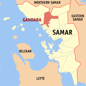
Gandara, officially the Municipality of Gandara(Waray: Bungto han Gandara), is a 2nd class municipality in the province of Samar, Philippines. According to the 2020 census, it has a population of 35,242 people.
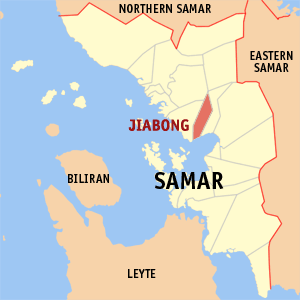
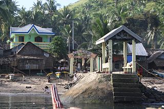
Jiabong, officially the Municipality of Jiabong, is a 5th class municipality in the province of Samar, Philippines. According to the 2020 census, it has a population of 19,205 people.

Tarangnan, officially the Municipality of Tarangnan, is a 4th class municipality in the province of Samar, Philippines. According to the 2020 census, it has a population of 25,713 people.
Borongan, officially the City of Borongan, is a 1st class component city and capital of the province of Eastern Samar, Philippines. According to the 2020 census, it has a population of 71,961 people.

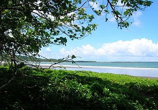
Guiuan, officially the Municipality of Guiuan, is a 2nd class municipality in the province of Eastern Samar, Philippines. According to the 2020 census, it has a population of 53,361 people.

The Roman Catholic Diocese of Calbayog is an ecclesiastical territory of the Catholic Church named after its episcopal see, Calbayog City, a city on the western side of the province of Samar in the Philippines.

Samar State University (SSU) is a public university in the Philippines located in the province of Samar. Its main campus is located in Barangay Guindaponan, Catbalogan City. The university has three other external campuses: Mercedes Campus, Catbalogan City; Paranas Campus, and Basey Campus.

Catbalogan, officially the City of Catbalogan, is a 5th class component city and capital of the province of Samar, Philippines. According to the 2020 census, it has a population of 106,440 people.
Cabiton-an is one of 58 rural barangays located in Daram, a 3rd class municipality in the province of Samar, Philippines.
Bagacay is one of the 21 barangays situated in the southeast portion of the Municipality of Hinabangan, Samar, Philippines. Bagacay is a wilderness on the eastern side of Samar Island, between the towns of Paranas (Wright) and Taft, 60 kilometers from the coast of provincial capital Catbalogan City.
Maulong refers to a barangay or village in Catbalogan City, Philippines located between the villages of Payao and Mercedes. It is 518 km southeast of Manila and 2 km from downtown Catbalogan City, the provincial capital of Samar.
Mercedes refers to a barangay or village in Catbalogan City, Philippines located between Maulong and Downtown Catbalogan. Barangay Mercedes is one of the 57 barangays of Catbalogan City.

Eastern Visayas is an administrative region in the Philippines, designated as Region VIII. It consists of three main islands, Samar, Leyte and Biliran. The region has six provinces, one independent city and one highly urbanized city namely, Biliran, Leyte, Northern Samar, Samar, Eastern Samar, Southern Leyte, Ormoc and Tacloban. The highly urbanized city of Tacloban is the sole regional center. These provinces and cities occupy the easternmost islands of the Visayas group of islands.
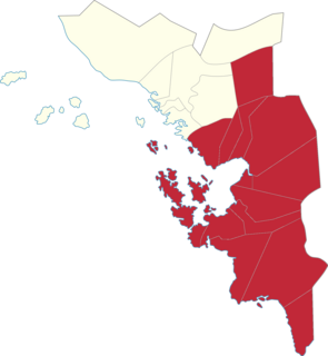
Samar's 2nd congressional district is one of the two congressional districts of the Philippines in the province of Samar. It has been represented in the House of Representatives of the Philippines since 1916 and earlier in the Philippine Assembly from 1907 to 1916. The district consists of the provincial capital city of Catbalogan and adjacent municipalities of Basey, Calbiga, Daram, Hinabangan, Jiabong, Marabut, Motiong, Paranas, Pinabacdao, San Jose de Buan, San Sebastian, Santa Rita, Talalora, Villareal and Zumarraga. It is currently represented in the 18th Congress by Sharee Ann T. Tan of the PDP–Laban.