2007 North Indian Ocean cyclone season

Last updated

2007 North Indian Ocean cyclone season
2007 North Indian Ocean cyclone season summary map.png
Season summary map
Seasonal boundaries
First system formedMay 1, 2007
Last system dissipatedNovember 16, 2007
Strongest storm
Name Gonu
  Maximum winds240 km/h (150 mph)
(3-minute sustained)
  Lowest pressure920 hPa (mbar)
Seasonal statistics
Depressions12
Deep depressions9
Cyclonic storms4
Severe cyclonic storms2
Very severe cyclonic storms2
Extremely severe cyclonic storms2
Super cyclonic storms1
Total fatalitiesAt least 16,248 total
Total damage~ $9.69 billion (2007 USD)
Related articles
North Indian Ocean tropical cyclone seasons
2005, 2006, 2007, 2008, 2009

The 2007 North Indian Ocean cyclone season was one of the most active North Indian Ocean cyclone seasons on record. The North Indian Ocean cyclone season has no official bounds, but cyclones tend to form between April and December, with peaks in May and November. These dates conventionally delimit the period of each year when most tropical cyclones form in the northern Indian Ocean.

Contents

The scope of this article is limited to the Indian Ocean in the Northern Hemisphere, east of the Horn of Africa and west of the Malay Peninsula. There are two main seas in the North Indian Ocean — the Arabian Sea to the west of the Indian subcontinent, abbreviated ARB by the India Meteorological Department (IMD); and the Bay of Bengal to the east, abbreviated BOB by the IMD.

The official Regional Specialized Meteorological Centre in this basin is the India Meteorological Department (IMD), while the Joint Typhoon Warning Center releases unofficial advisories. The tropical cyclone scale for this basin is detailed on the right. On average, 4 to 6 storms form in this basin every season. [1]

2007 was an active year for this basin; it was the most destructive season in known history at this time, only for the 2008 season to surpass it the next year. 2007 was also the first season to have multiple Category 5 cyclones (by the Saffir Simpson Scale), and the two Category 5's, Sidr and Gonu, were also the first named Category 5 cyclones to form in their respective seas; Gonu in the Arabian Sea, and Sidr in the Bay of Bengal. Some other notable storms of the season include Akash and Yemyin, both of which caused substantial damage and deaths. At least 4,545 deaths were reported, and damage was about 6.4 billion dollars.

Seasonal summary

Cyclone SidrCyclones BOB 03 and YemyinCyclones BOB 03 and YemyinCyclone GonuCyclone Akash2007 North Indian Ocean cyclone season

Systems

Depression BOB 01

Depression (IMD)
BOB 01 2007.jpg   BOB01 2007 track.png
DurationMay 1 – May 5
Peak intensity45 km/h (30 mph) (3-min); 998  hPa  (mbar)

An area of disturbed weather first formed east of the Malay Peninsula on April 26. It slowly consolidated, and the Thai Meteorological Department (TMD) designated the active low pressure area as a tropical depression on May 1 in the Gulf of Thailand. [2] Moving westwards, it made landfall in the coastal areas of Chumphon, and then moved into the Andaman Sea. [3] The system strengthened slightly, and late on May 3, the India Meteorological Department (IMD) designated it as a depression. It then began to move northwards, and in the morning of May 5, it made a second landfall on the coast of Rakhine State in Myanmar. The system weakened into an area of low pressure shortly after, and the IMD issued its last bulletin.

The TMD issued heavy rain and flash flood warnings for western provinces during the system's passage over the Isthmus of Kra. In Ratchaburi Province, disaster response teams prepared for the evacuation of settlements in mountainous terrain on May 3. [4] The next day, Prachuap Khiri Khan Province was declared a disaster zone after low-lying areas were flooded with waters up to one metre deep. In the capital municipality, a prison was inundated, necessitating the evacuation of prisoners to Ratchaburi. In addition, a portion of rail was flooded, but train services were not disrupted. In Surat Thani Province, mudslides halted traffic in the municipal area. Multiple landslide warnings were also issued in other provinces. Northwestern provinces also braced for heavy rains following the system's second landfall. [5]

TD2 caused about 18,485,400 Baht in damage. [6]

This system was not considered to be a tropical depression by any other agencies while in the Gulf of Thailand, but was tracked by the Joint Typhoon Warning Center. The storm attained a maximum wind speed of 30 knots (56 km/h) and a minimum pressure of 1006 hPa. [3]

Cyclonic Storm Akash

Cyclonic storm (IMD)
Category 1 tropical cyclone (SSHWS)
Akash May 14 2007 0700Z.jpg   Akash 2007 track.png
DurationMay 13 – May 15
Peak intensity85 km/h (50 mph) (3-min); 988  hPa  (mbar)

On May 13, the India Meteorological Department declared a depression over the east central Bay of Bengal. It formed on May 10, and continued to intensify gradually. The Joint Typhoon Warning Center issued a TCFA on May 13 shortly before the IMD upgraded it to a depression. Later that day, the JTWC upgraded it to a tropical cyclone, designating it 01B. On May 14, the IMD upgraded it to a deep depression, and six hours later it was designated the first cyclonic storm of the season, Akash. Akash continued to strengthen and the JTWC analysed it as having reached hurricane-force winds on May 14. It made landfall on the coast near the BangladeshMyanmar border early on May 15, and weakened quickly inland. The name, contributed by India, means "sky" in Hindi.

Akash killed at least one fisherman, and left about 100 others missing. Crops were destroyed and power was cut as Akash neared the coast, and almost 80,000 people had to be evacuated to cyclone shelters. [7] The seaport at Chittagong had to be closed, and all flights into and out of the city were cancelled. [8] Heavy rains caused by the rainbands of the cyclone led to the third One Day International cricket match between India and Bangladesh being abandoned. [9]

Overall, the storm killed at least 8 people in Myanmar. [10]

Super Cyclonic Storm Gonu

Super cyclonic storm (IMD)
Category 5 tropical cyclone (SSHWS)
Gonu 2007-06-04 0900Z.jpg   Gonu 2007 track.png
DurationJune 1 – June 7
Peak intensity240 km/h (150 mph) (3-min); 920  hPa  (mbar)

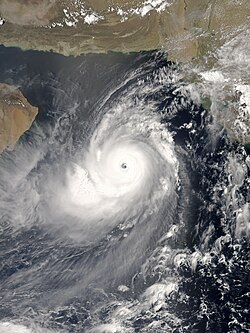
Gonu developed from a persistent area of convection in the eastern Arabian Sea on June 1. With a favorable upper-level environment and warm sea surface temperatures, it rapidly intensified to attain peak winds of 240 km/h (150 mph) on June 3, as warned by the India Meteorological Department. Gonu weakened after encountering dry air and cooler waters, and late on June 5, Gonu made landfall on the easternmost tip of Oman, becoming the strongest tropical cyclone to hit the Arabian Peninsula. Intense cyclones like Gonu have been extremely rare over the Arabian Sea, as most storms in this area tend to be small and dissipate quickly. [11]

The cyclone caused about $4 billion in damage (2007 USD) and 50 deaths in Oman, where the cyclone was considered the nation's worst natural disaster. Gonu dropped heavy rainfall near the eastern coastline, reaching up to 610 mm (24 in) which caused flooding and heavy damage. In Iran, the cyclone caused 28 deaths and $215 million in damage (2007 USD). Winds speeds of 100 km/h were recorded in Muscat, Oman at the time of landfall. [12]

Deep Depression BOB 03

Deep depression (IMD)
Tropical depression (SSHWS)
BOB 03 2007-06-21 0800Z.jpg   Yemyin 2007 track.png
DurationJune 21 – June 23
Peak intensity55 km/h (35 mph) (3-min); 988  hPa  (mbar)

A low-pressure area associated with the monsoon trough was first detected by the Naval Research Laboratory in the Bay of Bengal on June 17. Over the next few days, it developed deep flaring convection near an exposed low-level circulation centre (LLCC) as it drifted in the open sea. [13] Despite moderate to high vertical wind shear, the disturbance produced surface pressure falls of up to 2.7 mbar (hPa) in Port Blair, in the Andaman Islands, on June 19. [14] Convection persisted around the increasingly well-defined LLCC, and the disturbance continued to consolidate under favourable diffluence. [15]

Early on June 21, the India Meteorological Department (IMD) declared the area a depression, 430 km (270 mi) east-southeast of Kakinada, Andhra Pradesh, India. [16] Several hours later, the Joint Typhoon Warning Center (JTWC) issued a Tropical Cyclone Formation Alert (TCFA), with winds near 30 knots (56 km/h; 35 mph). [17] The depression moved quickly west-northwest towards the northern Andhra Pradesh coast. [16] A subtropical ridge to the north weakened the wind shear which had been hindering the storm's development, allowing for further intensification. [17] Later that day, the IMD upgraded the system to a deep depression. [18] As convection organised with increasing ocean heat content, the JTWC issued its first warning on Tropical Cyclone 03B. [19]

The deep depression made landfall near Kakinda early on June 22 local time. [20] The JTWC issued its final advisory later, as the system began to weaken due to land interaction and wind shear. [21] The next day, the IMD downgraded it to a depression while it crossed the Deccan Plateau. [22] The final warning was issued on June 24, despite the storm having moved into the Arabian Sea. The storm killed at least 140 people in India, [23] and another 213 people died in Karachi, Pakistan from rains and winds that might have been associated with an outer band of the cyclone. [24] The Pakistan Meteorological Department (PMD) had warned of heavy rains and wind from the system as early as Friday June 22. [25]

Cyclonic Storm Yemyin

Cyclonic storm (IMD)
Tropical storm (SSHWS)
Yemyin 2007-06-26 0650Z.jpg   Yemyin 2007 track.png
DurationJune 25 – June 26
Peak intensity65 km/h (40 mph) (3-min); 986  hPa  (mbar)

The JTWC noted in its Significant Tropical Weather Outlook for the North Indian Ocean on June 24 that strong monsoonal low-level flow contributed to increased cyclonic vorticity, with low vertical wind shear and warm sea surface temperatures. It warned that these factors could lead to a rapid regeneration of BOB 03. [26] Early on June 25, the JTWC issued the second TCFA for this system as its circulation crossed the coast into the Arabian Sea. [27] Shortly after the JTWC resumed advisories on the depression, [28] while IMD considered it as a separate system from BOB 03. [12]

As it moved northwest just off the Pakistan coast, winds of about 26 knots (48 km/h; 30 mph) and a surface pressure of 990 mbar (hPa) were observed in Karachi near midday on June 25. [29] According to the PMD, the centre of the system reached within 90 km (56 mi) of Karachi. [25] With favourable conditions and deep convection, the system intensified into a deep depression that day. [30] After further organization, it made its second landfall at about 0300 UTC June 26 along the Makran coast, near Ormara and Pasni, Balochistan province, in southwestern Pakistan. [25] [31] [32] Upon reaching land, the cyclone began to weaken slowly, [33] and the JTWC issued its last advisory late on June 26. [34]

The cyclone trapped 2 merchant ships: Al-Picaso and Lady Hamad, and 4 fishing boats: Al-Taif, Al-Noor, Sumbal Sultani and Al-Tariq, 100  nmi (190 km; 120 mi) off Karachi. The Pakistan Navy rescued 56 sailors from the merchant ships and 36 fishermen from the fishing boats after they were detected by Breguet Atlantique aircraft. [35] The heavy downpour also flooded the Kech Korandi riverine, inundating the city of Turbat and causing more than 10,000 people to evacuate their houses. [36] At least 380 people died in Balochistan, [37] with another 250 dead in Sindh and 100 in the North-West Frontier Province, [38] and further rains associated with the remnants of the cyclone hampered rescue efforts. The cyclone affected at least 10 districts of Balochistan and 4 districts of Sindh, affecting the lives of at least 1.5 million people. [39] Over 80 people were killed in floods associated with the remnants in Afghanistan. At least 2 million people were affected by the cyclone or indirectly by power cuts and water shortages in Balochistan. [40]

The PMD referred to the deep depression as Tropical Cyclone Yemyin, the next name on the list at the time. [25] The IMD did not operationally name the system, but the depression was upgraded to a cyclonic storm in post-analysis, and the IMD retroactively named it Yemyin. [41]

Deep Depression BOB 04

Deep depression (IMD)
Tropical storm (SSHWS)
04B 29 june 2007 0503Z.jpg   Cyclone 04B 2007 track.png
DurationJune 28 – June 30
Peak intensity55 km/h (35 mph) (3-min); 989  hPa  (mbar)

On June 28, an area of disturbed weather in the Bay of Bengal that had persisted as a well-marked low pressure area for two days became more organised. [42] The India Meteorological Department (IMD) noted the formation of a depression around 0000 UTC (5:30 am IST) southeast of Puri, Orissa, India. The IMD also stated that the system intensified into a deep depression three hours later whilst remaining "practically stationary". [43] The Joint Typhoon Warning Center (JTWC) issued a Tropical Cyclone Formation Alert shortly after, noting that observations from the eastern coast of India had recorded falls in pressure corresponding with the system's development. Furthermore, an upper-level anticyclone had formed over the disturbance, which would maintain the favourable wind shear conditions. [44] The JTWC initiated advisories later that day, [45] as the depression moved northwest towards the Orissa coast. [46] The depression made landfall near Puri early on June 29. [47] The JTWC then issued its last advisory later that day, as the system moved inland. [48] Early on June 30, with the system centred over Madhya Pradesh and Chhattisgarh, the IMD downgraded the system to a depression, [49] and discontinued advisories 6 hours later. [49]

At 0600 UTC (11 a.m. PST) on June 28, the Pakistan Meteorological Department (PMD) issued its first advisory regarding the remnants of the system. The PMD stated that the remnants "had the potential" to cause widespread heavy rain with strong winds in Sindh, Balochistan, Azad Kashmir and North-West Frontier provinces. This could worsen conditions in areas already flooded by Tropical Cyclone Yemyin. [50] In its fourth advisory on July 1, the PMD warned about the "high probability" of the system moving westward towards southern Sindh (instead of northwestward as previously projected), and regenerating over the Arabian Sea. [51] The remnants of Tropical Cyclone 04B were mentioned in a Significant Tropical Weather Advisory from the JTWC early on July 2. After crossing the Deccan Plateau, convection was southwest of the centre, in the Arabian Sea, while multiple associated low-level circulation centres had yet to re-emerge, and were located in west-central India, north-northeast of Mumbai. The area had favourable upper-level divergence, but high vertical wind shear. [52] Eventually, the circulation centre became fully exposed in unfavourable conditions, and the JTWC declared it "no longer suspect for development" later that day. [53]

While it was over western India adjoining the Arabian Sea, the deep convection associated with the remnants of the cyclone brought heavy rains to Maharashtra, causing disruptions in transport due to floods and high winds in Mumbai. Amravati district, northeast of Mumbai, was also severely affected by floods. [40] At least 43 people were killed in the state, and in Mumbai 243 mm (9.6 in) of rainfall was recorded. [54] 14 died in Gujarat state, and evacuations were conducted. Up to 462 mm (18.2 in) of rain was received in Bharuch district. [55]

Deep Depression BOB 05

Deep depression (IMD)
D.D BOB 05 Jul 5 2007 0505z.jpg   BOB05 2007 track.png
DurationJuly 4 – July 9
Peak intensity55 km/h (35 mph) (3-min); 988  hPa  (mbar)

On July 1, the Naval Research Laboratory (NRL) began to track a developing disturbance in the north Bay of Bengal. Following the formation of a low pressure area and circulation centre, the India Meteorological Department (IMD) initiated advisories, declaring it a depression, as it was located about 150 km (93 mi) southeast of Kolkata, West Bengal, in India, along the Bangladeshi coast. [56] The system was noted in the Significant Tropical Weather Advisory issued by the Joint Typhoon Warning Center (JTWC) that same day. The JTWC commented that the consolidated circulation centre was already overland, in southwest Bangladesh. [57] The next day, on July 5, as the depression tracked northwestward into Gangetic West Bengal, the IMD upgraded it to a deep depression. [58] It reached close to Bankura early on July 6, moving westward. [59] Phoolberia in West Bengal received 450 mm of rainfall in 48 hours between 5 and 6 July 2007. [12]

As the system weakened while over north Chhattisgarh, the IMD downgraded it to a depression on July 7. [60] The IMD then discontinued bulletins on July 8 as it weakened into a low pressure area over central Madhya Pradesh. [61] However, early the next morning it reintensified into a depression near Shivpuri, in northwestern Madhya Pradesh, and the IMD resumed advisories. [61] Later that day, the IMD issued its final bulletin. [62]

The depression caused heavy rains in Kolkata, with 16 casualties. Nearly 20% of the cumulative rainfall for the entire monsoon season fell in three days. [63]

Deep Depression BOB 06

Deep depression (IMD)
BOB 06 2007-08-06 0510Z.jpg   BOB06 2007 track.png
DurationAugust 5 – August 7
Peak intensity55 km/h (35 mph) (3-min); 984  hPa  (mbar)

On August 5, a low pressure area that had lingered in the northwestern Bay of Bengal organised into a depression about 230 km southeast of Balasore. The depression formed just as monsoonal rains and floods had killed over 200 people in the area. It deepened slightly and was upgraded to a deep depression late that night local time as it moved towards Orissa. The deep depression continued moving west-northwest and made landfall in Orissa between Chandbali and Paradip. In 48 hours, Alipingal in Orissa received 510 mm of rainfall between 5 & 6 August. In total 24 people died due to the flooding caused by the system. [12]

On August 7, Pakistan Meteorological Department issued its first weather advisory regarding the probability of regeneration of the system in Arabian Sea after crossing the Indian state of Gujarat, [64] though the system once again intensified into a deep depression but according to the IMD, it was a low pressure area.

Depression BOB 07

Depression (IMD)
BOB 07 2007-09-22 0732Z.jpg   BOB07 2007 track.png
DurationSeptember 21 – September 24
Peak intensity45 km/h (30 mph) (3-min); 990  hPa  (mbar)

On September 21, a low pressure area 230 km south-southeast of Puri was declared a depression by the IMD. The next day, it made landfall along the Orissa coast near Puri with winds around 45–55 km/h (28–34 mph). The city Kolkata in West Bengal received 440 mm of rainfall in 72 hours between 23 & 25 September. In total there were 75 deaths from the Depression. [12]

Depression BOB 08

Depression (IMD)
BOB 08 2007-10-28 0540Z.jpg   BOB08 2007 track.png
DurationOctober 27 – October 29
Peak intensity45 km/h (30 mph) (3-min); 1004  hPa  (mbar)

Late on October 27, an area of weather 600 km east-southeast of Chennai, India was designated Depression BOB 08/2007 by the IMD. [65] The depression degenerated into a low pressure area early on the 29th. [66] The depression caused heavy rains accompanied with strong winds in Chennai, with 15 casualties. [67] [68] Kavali in Andhra Pradesh received 550 mm of rainfall in 48 hours between 29 & 30 October. 19 deaths were reported from the state of Andhra Pradesh. [12]

Deep Depression ARB 02

Deep depression (IMD)
Tropical storm (SSHWS)
ARB 02 2007-10-28 0840Z.jpg   Cyclone 05A 2007 track.png
DurationOctober 27 – November 2
Peak intensity55 km/h (35 mph) (3-min); 1000  hPa  (mbar)

On October 27, a westward-moving disturbed area of weather formed about 885 nm east of Cape Guardafui, Somalia was designated Depression ARB 02/2007 by the IMD. [69] The next day, the Joint Typhoon Warning Center designated the depression as Tropical Cyclone 05A. [70] Soon after, the IMD upgraded the depression to a deep depression. [69] The Deep Depression did not develop and degenerated into a low pressure area on November 2 as it moved further west. [71] [72] [73] Agathi in Laskwadeep Islands received 70 mm of rainfall on 29 October. [12]

Extremely Severe Cyclonic Storm Sidr

Extremely severe cyclonic storm (IMD)
Category 5 tropical cyclone (SSHWS)
Sidr 2007-11-15 0650Z.jpg   Sidr 2007 track.png
DurationNovember 11 – November 16
Peak intensity215 km/h (130 mph) (3-min); 944  hPa  (mbar)

An area of disturbed weather developed near the Andaman Islands on November 9. It gradually became better organised as it passed to the south of the islands, and the system was designated Depression BOB 09 by the India Meteorological Department early on November 11. [74] The Joint Typhoon Warning Center upgraded it to Tropical Cyclone 06B at the same time. [75] Later that day, it intensified into a deep depression as it moved slowly north-westward. [76] The IMD upgraded the system to Cyclonic Storm Sidr early on November 12. [77] The system then began to intensify quickly as it moved slowly northwestward, and the IMD upgraded it to a severe cyclonic storm later that day [78] and a very severe cyclonic storm early the next day. [79]

As it intensified to a Category 4-equivalent cyclone on November 14, thousands of emergency officials were put on standby in eastern India and Bangladesh in advance of the storm's arrival. Massive evacuations of low-lying coastal areas also took place, although sheltering was only available for about 500,000 of the over 10 million residents of coastal areas. [80] The IMD also issued a cyclone alert for Orissa and West Bengal on November 14. [81] On the morning of November 15, the cyclone intensified to reach peak winds of 215 km/h (134 mph) according to the IMD, [82] and a peak of 260 km/h (160 mph) according to the JTWC. [83] Sidr officially made landfall around 1700 UTC later that day, [84] with sustained winds of 215 km/h (134 mph). [85] A station in coastal Bangladesh reported 80 knots (150 km/h) at 1800 UTC of 15 November 2007. According to media reports, the wind speed of about 200 km/h prevailed over Bangladesh coast at the time of landfall. [12] It weakened quickly after landfall and the final advisories were issued early on November 16. [86] The name Sidr was contributed by Oman; it is an Arabic name of a tree belonging to the Ziziphus family, specifically the Ziziphus spina-christi.

In the post season analysis, Sidr was upgraded to a Category 5-equivalent cyclone. This marks the first time that there have been two Category 5-equivalent storms in the Northern Indian Ocean in a single season. [87]

Season effects

This is a table of the storms in 2007 and their landfall(s), if any; the table does not include storms that did not make landfall, which is defined as the center of the storm moving over a landmass. Deaths in parentheses are additional and indirect (an example of an indirect death would be a traffic accident), but are still storm-related. Damage and deaths include totals while the storm was extratropical or a wave or low.

NameDatesPeak intensityAreas affectedDamage
(USD)
DeathsRefs
Category Wind speedPressure
BOB 01May 1–5Depression45 km/h (28 mph)998 hPa (29.47 inHg)Thailand, Myanmar$500,000None
Akash May 13 – 15Cyclonic Storm85 km/h (53 mph)990 hPa (29.24 inHg)Bangladesh, Myanmar, India$982 million14
Gonu June 1 – 7Super Cyclonic Storm240 km/h (150 mph)920 hPa (27.17 inHg)Oman, Iran$4.4 billion78
BOB 03 June 21 – 23Deep Depression55 km/h (34 mph)988 hPa (29.17 inHg)India, Pakistan453
Yemyin June 25 – 26Cyclonic Storm65 km/h (40 mph)986 hPa (29.12 inHg)India, Pakistan, Afghanistan$2.1 billion630
BOB 04June 28 – 30Deep Depression55 km/h (34 mph)989 hPa (29.18 inHg)India57
BOB 05July 4 – 9Deep Depression55 km/h (34 mph)988 hPa (29.17 inHg)Bangladesh16
BOB 06August 5 – 7Deep Depression55 km/h (34 mph)984 hPa (29.06 inHg)India24
BOB 07September 21 – 24Depression45 km/h (28 mph)990 hPa (29.24 inHg)India75
BOB 08October 27 – 29Depression45 km/h (28 mph)1004 hPa (29.65 inHg)India34
ARB 02October 27 – November 2Deep Depression55 km/h (34 mph)1000 hPa (29.53 inHg)SomaliaNoneNone
Sidr November 11 – 16Extremely Severe Cyclonic Storm215 km/h (134 mph)944 hPa (27.88 inHg)Bangladesh, West Bengal, Northeast India, Southwest China$2.21 billion~15,000
Season aggregates
11 systemsMay 1 – November 16240 km/h (150 mph)920 hPa (27.17 inHg)>$9.69 billion~16,248

See also

References and notes

  1. "IMD Cyclone Warning Services: Tropical Cyclones". India Meteorological Department. Archived from the original on November 4, 2008. Retrieved 2008-10-21.
  2. "Tropical depression in the Gulf of Thailand No. 8 (134 / 2550)". Thai Meteorological Department. May 1, 2007. Archived from the original on April 18, 2013. Retrieved March 14, 2022.
  3. 1 2 "Tropical depression in the Gulf of Thailand No. 10 (136 / 2550)". Thai Meteorological Department. May 1, 2007. Archived from the original on April 18, 2013. Retrieved 2008-10-21.
  4. "Heavy rain, flash flood warning in Thailand's north, west". MCOT English News. Archived from the original on October 11, 2007. Retrieved October 18, 2011.
  5. "Southern province declares disaster zone after flooding". MCOT English News. Archived from the original on October 11, 2007. Retrieved October 18, 2011.
  6. "Severe Weather Information Centre".
  7. "ABC Radio Australia".
  8. "Depression turns into cyclonic storm: Port operation stopped". The New Nation. May 14, 2007. Archived from the original on September 27, 2007. Retrieved October 21, 2008.
  9. "Cyclone alert ahead of final ODI". The New Nation. May 14, 2007. Archived from the original on August 4, 2007. Retrieved October 21, 2008.
  10. "Report On Cyclonic Disturbances Over North Indian Ocean During 2010" (PDF). Archived from the original (PDF) on July 16, 2011. Retrieved 2010-06-13.
  11. "NASA Earth Observatory: Tropical Cyclone Gonu". NASA. June 4, 2007. Archived from the original on August 2, 2007. Retrieved June 5, 2007.
  12. 1 2 3 4 5 6 7 8 "REPORT ON CYCLONIC DISTURBANCES OVER NORTH INDIAN OCEAN DURING 2007" (PDF). Archived from the original (PDF) on May 12, 2013. Retrieved December 15, 2013.
  13. "Significant Tropical Weather Advisory for the Indian Ocean 191800Z-201800Z". JTWC. June 19, 2007. Archived from the original on September 9, 2009. Retrieved 2008-10-23.
  14. "Significant Tropical Weather Advisory for the Indian Ocean 191800Z-201800ZJUN2007". Joint Typhoon Warning Center. June 20, 2007. Archived from the original on August 5, 2012. Retrieved March 14, 2022.
  15. "Depression over Bay of Bengal (BOB 03/2007/01)". India Meteorological Department. Archived from the original on November 16, 2007. Retrieved 2008-10-23.
  16. 1 2 "Depression over Bay of Bengal (BOB 03/2007/01)". India Meteorological Department. June 21, 2007. Archived from the original on November 16, 2007. Retrieved 2008-10-26.
  17. 1 2 "Tropical Cyclon Formation Alert". JTWC. June 21, 2007. Archived from the original on June 21, 2007. Retrieved 2008-10-26.
  18. "Deep Depression over Bay of Bengal (BOB 03/2007/03)". India Meteorological Department. June 21, 2007. Archived from the original on November 16, 2007. Retrieved 2008-10-23.
  19. https://www.webcitation.org/5PlTDy9FR?url=http://metocph.nmci.navy.mil/jtwc/warnings/io032007web.txt [ dead link ]
  20. "Deep Depression over Bay of Bengal (BOB 03/2007/06)". India Meteorological Department. June 21, 2007. Archived from the original on November 16, 2007. Retrieved 2008-10-26.
  21. "Tropical Cyclone 03B Warning Nr 003". Joint Typhoon Warning Center. Archived from the original on June 27, 2007. Retrieved 2008-10-23.
  22. "Depression over Marathawada (BOB 03/2007/09)". India Meteorological Department. June 23, 2007. Archived from the original on November 16, 2007. Retrieved 2008-10-23.
  23. "Flood devastation in South Asia". BBC Online. June 26, 2007. Archived from the original on November 23, 2008. Retrieved October 23, 2008.
  24. "Storms in Karachi kill 200 people". BBC Online. June 24, 2007. Archived from the original on November 23, 2008. Retrieved October 23, 2008.
  25. 1 2 3 4 "UPDATE: Weather Advisory No.6 for Sindh / Balochistan. Tropical Cyclone 03B Warning". Government of Pakistan. Ministry of Defence. Pakistan Meteorological Department. June 26, 2007. Archived from the original on June 29, 2007. Retrieved 2008-10-23.
  26. "Significant Tropical Weather Advisory for the Indian Ocean Reissued 241200Z-241800ZJUN2007". Joint Typhoon Warning Center. June 24, 2007. Archived from the original on June 24, 2007. Retrieved 2008-10-23.
  27. "Significant Tropical Weather Advisory for the Indian Ocean 250000Z-251800ZJUN2007". Joint Typhoon Warning Center. June 25, 2007. Archived from the original on December 1, 2007. Retrieved 2008-10-26.
  28. "Tropical Cyclone 03B Warning Nr 004". Joint Typhoon Warning Center. June 25, 2007. Archived from the original on June 27, 2007. Retrieved 2008-10-26.
  29. "Tropical Cyclone 03B Warning Nr 005". JTWC. June 25, 2007. Archived from the original on June 27, 2007. Retrieved 2008-11-02.
  30. "Special Tropical Weather Outlook". India Meteorological Department. June 25, 2007. Retrieved November 13, 2008.[ permanent dead link ]
  31. "Deep Depression Over Northeast Arabian Sea". India Meteorological Department. June 26, 2007. Archived from the original on November 16, 2007. Retrieved 2008-11-13.
  32. "Tropical Cyclone 03B Warning Nr 008". Joint Typhoon Warning Center. June 26, 2007. Archived from the original on June 27, 2007. Retrieved 2008-11-13.
  33. "Tropical Cyclone 03B Warning Nr. 009". Joint Typhoon Warning Center. June 26, 2007. Retrieved November 13, 2008.[ permanent dead link ]
  34. "Tropical Cyclone 03B Warning Nr 010". Joint Typhoon Warning Center. June 26, 2007. Archived from the original on June 27, 2007. Retrieved 2008-11-13.
  35. "NEWS : AAJ Television: Pakistan's Premier Channel". Archived from the original on May 17, 2007. Retrieved June 27, 2007.
  36. "The News International: Latest News Breaking, Pakistan News". Archived from the original on September 18, 2016. Retrieved June 27, 2007.
  37. "Pakistan cyclone death toll hits 380". The Times of India . India. July 3, 2007. Archived from the original on October 17, 2012. Retrieved July 3, 2007.
  38. "Pakistan cyclone death toll hits 380, thousands face starvation- Hindustan Times". Hindustan Times. India. July 2, 2007. Archived from the original on June 1, 2009. Retrieved October 26, 2008.
  39. "More 13 bodies recovered as dozens killed, hundreds missing in Balochistan rains". Geo Television Network (via Webcitation.org). July 5, 2007. Archived from the original on October 17, 2020. Retrieved November 13, 2008.
  40. 1 2 "Pakistan flood toll rises to 240". BBC News. July 3, 2007. Archived from the original on November 22, 2008. Retrieved October 26, 2008.
  41. At the time, the official WMO body responsible for tropical cyclones in the Arabian Sea, the India Meteorological Department (IMD), did not name the storm. However, the IMD reassessed the system to have reached cyclonic storm strength, and retroactively named the storm Yemyin.
  42. "Dems–RSMC Tropical Cyclones New Delhi". Archived from the original on June 11, 2008. Retrieved June 26, 2007.
  43. https://www.webcitation.org/5PvpqZNmH?url=http://twister.sbs.ohio-state.edu/text/station/DEMS/WWIN40.DEMS [ dead link ]
  44. https://www.webcitation.org/5Pvq5HH2c?url=http://metocph.nmci.navy.mil/jtwc/warnings/io9607web.txt [ dead link ]
  45. "Archived copy". Archived from the original on June 30, 2007. Retrieved June 28, 2007.{{cite web}}: CS1 maint: archived copy as title (link)
  46. "Dems–RSMC Tropical Cyclones New Delhi". Archived from the original on June 11, 2008. Retrieved June 28, 2007.
  47. "Dems–RSMC Tropical Cyclones New Delhi". Archived from the original on June 11, 2008. Retrieved June 29, 2007.
  48. "Archived copy". Archived from the original on June 30, 2007. Retrieved June 29, 2007.{{cite web}}: CS1 maint: archived copy as title (link)
  49. 1 2 "Dems–RSMC Tropical Cyclones New Delhi". Archived from the original on June 11, 2008. Retrieved June 30, 2007.
  50. "Government of Pakistan". Archived from the original on June 29, 2007. Retrieved June 29, 2007.
  51. "Government of Pakistan". Archived from the original on June 29, 2007. Retrieved July 1, 2007.
  52. "Archived copy". Archived from the original on April 14, 2009. Retrieved July 2, 2007.{{cite web}}: CS1 maint: archived copy as title (link)
  53. "Significant Tropical Weather Advisory for the Indian Ocean". Joint Typhoon Warning Center. July 2, 2007. Retrieved November 13, 2008.[ permanent dead link ]
  54. "Heavy rains leave 43 dead". Independent Online (South Africa). July 2, 2007. Retrieved November 13, 2008.
  55. "Rains claim 14 lives in Gujarat; Army mobilised". The Times of India . India. July 2, 2007. Archived from the original on October 17, 2012. Retrieved August 15, 2007.
  56. https://www.webcitation.org/5Q7ikITsu?url=http://sonicfighters.com/rattleman/013031-rsmc.htm [ dead link ]
  57. ftp://ftp.met.fsu.edu/pub/weather/tropical/GuamStuff/2007070409-ABIO.PGTW%5B%5D
  58. "Archived copy". Archived from the original on June 7, 2007. Retrieved July 6, 2007.{{cite web}}: CS1 maint: archived copy as title (link)
  59. "Dems–RSMC Tropical Cyclones New Delhi". Archived from the original on June 11, 2008. Retrieved July 6, 2007.
  60. "Dems–RSMC Tropical Cyclones New Delhi". Archived from the original on June 11, 2008. Retrieved July 7, 2007.
  61. 1 2 "Dems–RSMC Tropical Cyclones New Delhi". Archived from the original on June 11, 2008. Retrieved July 9, 2007.
  62. "Dems–RSMC Tropical Cyclones New Delhi". Archived from the original on June 11, 2008. Retrieved July 10, 2007.
  63. "Calcutta battered by monsoon rain". BBC News. July 5, 2007. Retrieved April 22, 2010.
  64. "Government of Pakistan". Archived from the original on August 8, 2007. Retrieved August 8, 2007.
  65. "Depression over southwest and adjoining southeast Bay of Bengal (BOB 08/2007/01)". India Meteorological Department. October 28, 2007. Archived from the original on November 16, 2007. Retrieved 2008-10-26.
  66. "Archived copy". Archived from the original on September 24, 2015. Retrieved October 29, 2007.{{cite web}}: CS1 maint: archived copy as title (link)
  67. "15 killed in rain-hit TN; schools, colleges shut". CNN-IBN. October 29, 2007. Archived from the original on May 28, 2009. Retrieved October 26, 2008.
  68. TIMESNOW.tv – Latest Breaking News, Big News Stories, News Videos
  69. 1 2 "Archived copy". Archived from the original on June 7, 2007. Retrieved October 28, 2007.{{cite web}}: CS1 maint: archived copy as title (link)
  70. ftp://ftp.met.fsu.edu/pub/weather/tropical/GuamStuff/2007102803-WTIO.PGTW%5B%5D
  71. https://www.webcitation.org/5T3NFSMbH?url=http://www.sonicfighters.com/rattleman/other/rsmc.htm [ dead link ]
  72. "Archived copy". Archived from the original on June 7, 2007. Retrieved November 2, 2007.{{cite web}}: CS1 maint: archived copy as title (link)
  73. ftp://ftp.met.fsu.edu/pub/weather/tropical/GuamStuff/2007110203-WTIO.PGTW%5B%5D
  74. https://www.webcitation.org/5THCn2gZT?url=http://sonicfighters.com/rattleman/other/053736-cwind.htm [ dead link ]
  75. ftp://ftp.met.fsu.edu/pub/weather/tropical/GuamStuff/2007111109-WTIO.PGTW%5B%5D
  76. "Archived copy". Archived from the original on September 24, 2015. Retrieved November 12, 2007.{{cite web}}: CS1 maint: archived copy as title (link)
  77. "Dems–RSMC Tropical Cyclones New Delhi". Archived from the original on June 11, 2008. Retrieved November 12, 2007.
  78. "Tropical Storm "SIDR" Advisory No. Four". India Meteorological Department. November 12, 2007. Archived from the original on November 16, 2007. Retrieved 2007-11-12.
  79. "Tropical Storm "SIDR" Advisory No. Seven". India Meteorological Department via Webcitation.org. November 13, 2007. Archived from the original on November 16, 2007. Retrieved 2007-11-12.
  80. "Cyclone forces Bangladesh evacuations". USA Today. November 16, 2007. Retrieved October 26, 2008.
  81. "National News Detail". deepikaglobal.com. Archived from the original on November 22, 2007. Retrieved October 18, 2011.
  82. "Tropical Storm "SIDR" Advisory No. Twenty Eight Issued at 1500 UTC of 15 November 2007". India Meteorological Department. November 15, 2007. Archived from the original on November 16, 2007. Retrieved 2008-11-02.
  83. "Tropical Cyclone 06B (SIDR) Warning Nr 012". JTWC. November 15, 2007. Retrieved November 2, 2008.[ permanent dead link ]
  84. "Tropical Storm "SIDR" Advisory No. Thirty issued at 2100 UTC of 15 November, 2007Tropical Storm "SIDR" Advisory No. Thirty issued at 2100 UTC of 15 November 2007". India Meteorological Department. November 15, 2007. Archived from the original on November 16, 2007. Retrieved 2008-11-02.
  85. "Very Severe Cyclonic Storm (SIDR) Crossed Bangladesh coast. (BOB 09/2007/34)". India Meteorological Department. November 16, 2007. Archived from the original on November 15, 2007. Retrieved 2008-11-02.
  86. "Cyclonic Storm (SIDR) weaken into a depression over Bangladesh and adjoining areas. (BOB 09/2007/37)". India Meteorological Department. November 16, 2007. Archived from the original on November 15, 2007. Retrieved 2008-11-02.
  87. "Best Track Indian Ocean". JTWC. 2007. Archived from the original (TXT) on March 10, 2010. Retrieved November 2, 2008.

Related Research Articles

<span class="mw-page-title-main">Cyclone Agni</span> North Indian Ocean severe cyclonic storm in 2004

Severe Cyclonic Storm Agni was a tropical cyclone of the 2004 North Indian Ocean cyclone season notable for its record proximity to the equator. It was the second North Indian Ocean cyclone to receive a name, after Onil earlier in the year. Agni formed on November 28 well to the southwest of India in the Arabian Sea, and steadily intensified as it tracked northwestward. The Joint Typhoon Warning Center (JTWC) estimated peak 1 minute sustained winds of 120 km/h (75 mph), while the India Meteorological Department (IMD) estimated peak 3 minute sustained winds of 100 km/h (60 mph); the IMD is the official warning center for the north Indian Ocean. After peaking, it weakened due to wind shear, dry air, and cooler waters, and the JTWC issued its final advisory on December 3 as it approached the coast of Somalia. The remnants of Agni moved along the Somalian coastline until dissipating on December 5.

<span class="mw-page-title-main">2008 North Indian Ocean cyclone season</span> North Indian Ocean tropical cyclone season

The 2008 North Indian cyclone season was one of the most disastrous tropical cyclone seasons in modern history, with tropical cyclones leaving more than 140,000 people dead and causing more than US$15 billion in damage, making it the costliest season in the North Indian Ocean, until it was made second in 2020. The season has no official bounds but cyclones tend to form between April and December. These dates conventionally delimit the period of each year when most tropical cyclones form in the northern Indian Ocean. There are two main seas in the North Indian Ocean—the Bay of Bengal to the east of the Indian subcontinent and the Arabian Sea to the west of India. The official Regional Specialized Meteorological Centre in this basin is the India Meteorological Department (IMD), while the Joint Typhoon Warning Center releases unofficial advisories. An average of four to six storms form in the North Indian Ocean every season with peaks in May and November. Cyclones occurring between the meridians 45°E and 100°E are included in the season by the IMD.

<span class="mw-page-title-main">Cyclone Akash</span> North Indian Ocean cyclonic storm in 2007

Cyclonic Storm Akash was the first named tropical cyclone of the 2007 North Indian Ocean cyclone season. Warned by both India Meteorological Department (IMD) and Joint Typhoon Warning Center (JTWC), it formed from an area of disturbed weather on the Bay of Bengal on May 12, and gradually organized as it drifted northward. An eye began to develop as it approached land, and after reaching peak 3-min sustained winds of 85 km/h (55 mph) it struck about 115 km (71 mi) south of Chittagong in Bangladesh. Akash rapidly weakened over land, and advisories were discontinued on May 15.

<span class="mw-page-title-main">Timeline of the 2007 North Indian Ocean cyclone season</span>

Below is a timeline of the 2007 North Indian Ocean cyclone season, documenting major events with regards to tropical cyclone formation, strengthening, weakening, landfall, extratropical transition, as well as dissipation. The 2007 North Indian Ocean cyclone season was an ongoing event in the annual cycle of tropical cyclone formation.

<span class="mw-page-title-main">Cyclones BOB 03 and Yemyin</span> North Indian Ocean deep depression and cyclonic storm in 2007

Deep Depression BOB 03 and Cyclonic Storm Yemyin were a pair of deadly tropical cyclones that made landfalls on India and Pakistan in June 2007. The Pakistan Meteorological Department referred to both as Tropical Cyclone 03B, naming it "Tropical Cyclone Yemyin". At the time, the official WMO body responsible for tropical cyclones in the Arabian Sea, the India Meteorological Department (IMD), did not name them. However, the IMD reassessed the second system to have reached cyclonic storm strength, and retroactively named it Yemyin.

<span class="mw-page-title-main">2009 North Indian Ocean cyclone season</span> North Indian Ocean tropical cyclone season

The 2009 North Indian Ocean cyclone season was an event in the annual cycle of tropical cyclone formation. The North Indian Ocean cyclone season has no official bounds, but cyclones tend to form between April and December, with peaks in May and November. These dates conventionally delimit the period of each year when most tropical cyclones form in the northern Indian Ocean.

<span class="mw-page-title-main">Cyclone Rashmi</span>

Cyclonic Storm Rashmi was the seventh tropical cyclone of the 2008 North Indian Ocean cyclone season and second cyclonic storm, as well as the fifth tropical cyclone in the Bay of Bengal that year. A fairly weak tropical cyclone, it caused some notable damage in Bangladesh and India.

<span class="mw-page-title-main">Cyclone Nisha (2008)</span> 2008 tropical cyclone in the Indian Ocean

Cyclonic Storm Nisha was a fairly weak but catastrophic tropical cyclone that struck Sri Lanka, and India which killed over 200. It was the ninth tropical cyclone of the 2008 North Indian Ocean cyclone season, and the seventh tropical cyclone in the Bay of Bengal that year.

<span class="mw-page-title-main">2010 North Indian Ocean cyclone season</span> North Indian Ocean tropical cyclone season

The 2010 North Indian Ocean cyclone season was the one of the most active tropical cyclone season in the North Indian Ocean since 1998. The season saw 8 depressions and 5 named storms forming in the region.

<span class="mw-page-title-main">Cyclone Phyan</span>

Cyclonic Storm Phyan developed as a tropical disturbance to the southwest of Colombo in Sri Lanka on November 4, 2009. Over the next couple of days, the disturbance gradually developed before weakening as it made landfall on Southern India on November 7. After the disturbance emerged into the Arabian Sea, it rapidly became more of a concern to the India Meteorological Department (IMD) reporting early on November 9 that the disturbance had intensified into a Depression, and designated it as Depression ARB 03 whilst the Joint Typhoon Warning Center (JTWC) issued a Tropical Cyclone Formation Alert. Later that day, the JTWC designated the system as Cyclone 04A. During the next day, the Depression turned towards the northeast the IMD reported that it had intensified into a Cyclonic Storm and named it as Phyan.

<span class="mw-page-title-main">2011 North Indian Ocean cyclone season</span> North Indian Ocean tropical cyclone season

The 2011 North Indian Ocean cyclone season was the least active tropical cyclone season in the North Indian Ocean since 1993. Only two cyclonic storms formed, below the average of four to six. The North Indian Ocean cyclone season has no official bounds, but cyclones tend to form between April and December, with peaks in May and November. These dates conventionally delimit the period of each year when most tropical cyclones form in the northern Indian Ocean. The scope of this article is limited to the Indian Ocean in the Northern Hemisphere, east of the Horn of Africa and west of the Malay Peninsula. There are two main seas in the North Indian Ocean — the Arabian Sea to the west of the Indian subcontinent, abbreviated ARB by the India Meteorological Department (IMD); and the Bay of Bengal to the east, abbreviated BOB by the IMD.

<span class="mw-page-title-main">2012 North Indian Ocean cyclone season</span> North Indian Ocean tropical cyclone season

The 2012 North Indian Ocean cyclone season was a very inactive season. The season had a very late start, with the first system forming in October. During the season, only five systems formed, of which only two became cyclonic storms. Both the storms made landfall, and they, along with the deep depressions, were responsible for 128 deaths and economic losses worth at least $56.7 million.

<span class="mw-page-title-main">Timeline of the 2012 North Indian Ocean cyclone season</span>

The 2012 North Indian Ocean cyclone season was an event in the annual cycle of tropical cyclone formation. The scope of this article is limited to the Indian Ocean in the Northern Hemisphere, east of the Horn of Africa and west of the Malay Peninsula. There are two main seas in the North Indian Ocean — the Arabian Sea to the west of the Indian subcontinent, abbreviated ARB by the India Meteorological Department (IMD); and the Bay of Bengal to the east, abbreviated BOB by the IMD. The official Regional Specialized Meteorological Centre in this basin is the India Meteorological Department (IMD), while the Joint Typhoon Warning Center releases unofficial advisories. This timeline includes information that was operationally released, meaning that data from post-storm reviews by the IMD, such as a storm that was not operationally warned upon, has not been included. This timeline documents tropical cyclone formations, strengthening, weakening, landfalls, and dissipations during the season.

<span class="mw-page-title-main">2013 North Indian Ocean cyclone season</span> North Indian Ocean tropical cyclone season

The 2013 North Indian Ocean cyclone season was an event in the annual cycle of tropical cyclone formation, in which tropical cyclones formed in the North Indian Ocean and Arabian Sea. The season had no official bounds, but cyclones typically formed between May and December, with the peak from October to November. These dates conventionally delimit the period of each year when most tropical cyclones form in the northern Indian Ocean.

<span class="mw-page-title-main">2014 North Indian Ocean cyclone season</span> North Indian Ocean tropical cyclone season

The 2014 North Indian Ocean cyclone season was an event in the annual cycle of tropical cyclone formation. The season included two very severe cyclonic storms, both in October, and one other named cyclonic storm, classified according to the tropical cyclone intensity scale of the India Meteorological Department. Cyclone Hudhud is estimated to have caused US$3.58 billion in damage across eastern India, and more than 120 deaths.

<span class="mw-page-title-main">2016 North Indian Ocean cyclone season</span> North Indian Ocean tropical cyclone season

The 2016 North Indian Ocean cyclone season was an event in the annual cycle of tropical cyclone formation. It was the deadliest season since 2010, killing more than 400 people. The season was an average one, seeing four named storms, with one further intensifying into a very severe cyclonic storm. The first named storm, Roanu, developed on 19 May while the season's last named storm, Vardah, dissipated on 18 December. The North Indian Ocean cyclone season has no official bounds, but cyclones tend to form between April and December, with the two peaks in May and November. These dates conventionally delimit the period of each year when most tropical cyclones form in the northern Indian Ocean.

<span class="mw-page-title-main">2019 North Indian Ocean cyclone season</span> North Indian Ocean tropical cyclone season

The 2019 North Indian Ocean cyclone season was the most active North Indian Ocean cyclone season on record, in terms of cyclonic storms, however the 1992 season was more active according to the Joint Typhoon Warning Center. The season featured 12 depressions, 11 deep depressions, 8 cyclonic storms, 6 severe cyclonic storms, 6 very severe cyclonic storms, 3 extremely severe cyclonic storms, and 1 super cyclonic storm, Kyarr, the first since Cyclone Gonu in 2007. Additionally, it was also the third-costliest season recorded in the North Indian Ocean, only behind the 2020 and 2008 seasons.

<span class="mw-page-title-main">2020 North Indian Ocean cyclone season</span> North Indian Ocean tropical cyclone season

The 2020 North Indian Ocean cyclone season was the costliest North Indian Ocean cyclone season on record, mostly due to the devastating Cyclone Amphan. The North Indian Ocean cyclone season has no official bounds, but cyclones tend to form between April and November, with peaks in late April to May and October to November. These dates conventionally delimit the period of each year when most tropical cyclones form in the northern Indian Ocean. The season began on May 16 with the designation of Depression BOB 01 in the Bay of Bengal, which later became Amphan. Cyclone Amphan was the strongest storm in the Bay of Bengal in 21 years and would break Nargis of 2008's record as the costliest storm in the North Indian Ocean. The season concluded with the dissipation of Cyclone Burevi on December 5. Overall, the season was slightly above average, seeing the development of five cyclonic storms.

<span class="mw-page-title-main">2022 North Indian Ocean cyclone season</span> Tropical cyclone season

The 2022 North Indian Ocean cyclone season was an event in the annual cycle of tropical cyclone formation. It was an above-average season in terms of depressions and average in terms of deep depressions, but slightly below-average in terms of cyclonic storms. It was also the least deadly North Indian Ocean cyclone season since 1988, according to official data. The season's strongest tropical cyclone was Cyclone Asani, with maximum wind speeds of 100 km/h and a minimum barometric pressure of 982 hPa. The North Indian Ocean cyclone season has no official bounds, but cyclones tend to form between April and December, with the peak from May to November. These dates conventionally delimit the period of each year when most tropical cyclones form in the northern Indian Ocean.

<span class="mw-page-title-main">2023 North Indian Ocean cyclone season</span> North Indian Ocean tropical cyclone season

The 2023 North Indian Ocean cyclone season is an ongoing event in the annual cycle of tropical cyclone formation. The North Indian Ocean cyclone season has no official bounds, but cyclones tend to form between April and December, with the peak from May to November. These dates conventionally delimit the period of each year when most tropical cyclones form in the northern Indian Ocean.