2001 North Indian Ocean cyclone season

Last updated

2001 North Indian Ocean cyclone season
2001 North Indian Ocean cyclone season summary.png
Season summary map
Seasonal boundaries
First system formedMay 21, 2001
Last system dissipatedNovember 12, 2001
(January 1, 2002 per JTWC)
Strongest storm
Name ARB 01
  Maximum winds215 km/h (130 mph)
(3-minute sustained)
  Lowest pressure932 hPa (mbar)
Seasonal statistics
Depressions6, 1 unofficial
Deep depressions4, 1 unofficial
Cyclonic storms4, 1 unofficial
Severe cyclonic storms1
Very severe cyclonic storms1
Extremely severe cyclonic storms1
Total fatalities108 total
Total damage$104 million (2001 USD)
Related articles
North Indian Ocean tropical cyclone seasons
1999, 2000, 2001, 2002, 2003

The 2001 North Indian Ocean cyclone season was fairly quiet, although activity was evenly spread between the Arabian Sea and the Bay of Bengal. There were six depressions tracked by the India Meteorological Department (IMD), which is the official Regional Specialized Meteorological Center for the northern Indian Ocean. The agency also tracked four cyclonic storms, which have maximum winds of at least 65 km/h (40 mph) sustained over 3 minutes. The American-based Joint Typhoon Warning Center (JTWC) tracked an additional storm Tropical Storm Vamei which crossed over from the South China Sea at a record-low latitude.

Contents

The first storm originated on May 21, and became the strongest recorded storm in the Arabian Sea at the time. The IMD estimated peak 3 minute winds of 215 km/h (135 mph) while the storm was off the west coast of India. The storm weakened greatly before making landfall in Gujarat, and although impact on land was minor, it left up to 950 fishermen missing. A few weeks later, the first Bay of Bengal system originated a short-lived depression that dropped heavy rainfall upon striking Odisha. After a period of inactivity during the monsoon season, [1] there were cyclonic storms in September and October in the northern Arabian Sea. Both lasted only a few days and dissipated due to unfavorable wind shear. Another cyclonic storm formed in the Bay of Bengal and struck Andhra Pradesh, which dropped heavy rainfall that was equivalent to 300% of the average October precipitation total. The rains caused flooding, particularly in Cuddapah, where a dam was deliberately opened and inundated the town overnight. There were 153 deaths due to the storm and RS5 billion (Indian rupees, US$104 million) in damage. The final storm of the season tracked by the IMD was a short-lived depression in November in the Bay of Bengal.

Season summary

Tropical Storm Vamei2001 India cyclone2001 North Indian Ocean cyclone season

The India Meteorological Department (IMD) in New Delhi the official Regional Specialized Meteorological Center for the northern Indian Ocean as recognized by the World Meteorological Organization issued warnings for tropical cyclones developing in the region. The basin's activity is sub-divided between the Arabian Sea and the Bay of Bengal on opposite coasts of India, and is generally split before and after the monsoon season. The IMD utilized satellite imagery to track storms, [2] and used the Dvorak technique to estimate intensity. [1]

Toward the end of the year, convection was generally lower than normal in the Bay of Bengal, despite being a typical hotspot for activity. There were no deaths or damage throughout the year outside of India, and damage there was lower than what occurred in the previous few seasons. [2]

Systems

Extremely Severe Cyclonic Storm ARB 01

Extremely severe cyclonic storm (IMD)
Category 3 tropical cyclone (SSHWS)
ARB 01 2001-05-23 Terra.jpg   Cyclone 01A 2001 track.png
DurationMay 21 – May 28
Peak intensity215 km/h (130 mph) (3-min);
932  hPa  (mbar)

The first storm of the season originated from a tropical disturbance that formed east of Somalia on May 18. Over the following few days, the system gradually organized, [3] becoming a depression on May 21. It moved eastward toward the coastline of southwestern India and rapidly intensified on May 22, strengthening from a deep depression to a very severe cyclonic storm within 24 hours. [1] After approaching the coastline, the storm turned to the north and northwest away from land due to a ridge. [3] Based on the well-defined eye and the storm's satellite presentation, [1] the IMD estimated peak winds of 215 km/h (135 mph) on May 24, and the JTWC estimated 1 minute winds of 205 km/h (125 mph). [4] It became the strongest storm on record in the Arabian Sea, only to be surpassed by Cyclone Gonu in 2007. [5] Soon after reaching peak intensity, the cyclone rapidly weakened as it turned northward. By May 28, it had deteriorated into a deep depression, and the IMD downgraded the storm to a remnant low before the circulation reached the Gujarat coast. [4]

Ahead of the storm, all ports in Gujarat, including Kandla, one of the largest in the country, were closed as a precautionary measure. [6] Over 10,000 people were evacuated from coastal areas in the threatened region. Offshore, between 1,500 and 2,000 fishing vessels lost contact with the mainland immediately after the storm. [7] However, because the storm remained offshore, the coast only experienced minor damage, although rainfall was widespread. [1] About 200 houses were washed away in Kosamba, [3] and one person died in Jamnagar. [1] About 950 fishermen were missing after the storm, which prompted a helicopter search. [8]

Cyclonic Storm ARB 02

Cyclonic storm (IMD)
Tropical storm (SSHWS)
ARB 2001-09-26 Terra.jpg   Cyclone 02A 2001 track.png
DurationSeptember 25 – September 28
Peak intensity65 km/h (40 mph) (3-min);
1000  hPa  (mbar)

An upper-level disturbance spawned a low-pressure area in the eastern Arabian Sea on September 24. [1] It initially consisted of a well-defined circulation on the eastern edge of an area of convection about 370 km (230 mi) west-southwest of Mumbai. With low wind shear beneath the subtropical ridge, the system gradually organized and developed curved banding features while moving west-northwestward. [9] At 0900 UTC on September 24, the IMD classified the system as a depression, and nine hours later upgraded it further to a deep depression. [1] On the same day, the JTWC issued a Tropical Cyclone Formation Alert, although they did not begin advisories due to the center being on the east side of the convection. [9] At 0900 UTC on September 25, the IMD upgraded the system to a cyclonic storm, [1] estimating peak winds of 65 km/h (40 mph). [10]

Early on September 26, the circulation moved beneath the convection, prompting the JTWC to begin advisories on Tropical Cyclone 02A. [9] Around that time, the storm's outskirts dropped light rainfall in western India. [1] Forecasters initially anticipated that the storm would strengthen to winds of 95 km/h (60 mph) and strike the southern Arabian Peninsula. However, persistent wind shear dislocated the circulation from the convection and imparted weakening. [9] The IMD downgraded the storm to a deep depression and later depression on September 27, [1] by which time the thunderstorms were rapidly dwindling. The JTWC issued their last advisory on September 28 after the circulation had no nearby convection. At that time, the storm was located 185 km (115 mi) east-southeast of Masirah Island off Oman. [9] The IMD also downgraded the depression to a low-pressure area on September 28 and noted that the remnant system became poorly defined the following day. [1]

Cyclonic Storm ARB 03

Cyclonic storm (IMD)
Tropical storm (SSHWS)
Tropical Cyclone 03A 09 oct 2001 0555Z.jpg   Cyclone 03A 2001 track.png
DurationOctober 7 – October 13
Peak intensity65 km/h (40 mph) (3-min);
998  hPa  (mbar)

Similar to the previous storm, an area of convection formed in the Arabian Sea about 185 km (115 mi) west-southwest of Mumbai on October 7. It was associated with a circulation that moved westward from the Indian Coast, [11] which formed as a well-defined low-pressure area over western India. [1] The convection organized and increased, aided by low wind shear and good outflow. [11] Late on October 8, the IMD classified the system as a depression, and early the next day upgraded it to a deep depression. [1] A low-level circulation formed beneath a well-defined mid-level storm, with intense convection and strong winds north of the center. At 06:00 UTC on October 9, the JTWC began classifying the system as Tropical Cyclone 03A. [1]

With increasing banding features, the storm strengthened while moving west-northwestward, steered by a ridge to the north. [1] At 09:00 UTC that day, the IMD upgraded the system to a cyclonic storm, estimating peak winds of 65 km/h (40 mph). [1] Soon thereafter, the storm began weakening due to increased dry air and the upper-level environment becoming unfavorable. The thunderstorms diminished and disappeared over the circulation by October 10. That day, the JTWC discontinued advisories, [11] and the IMD downgraded it to a remnant low-pressure area south of Pakistan. The storm brushed the Indian coast with rainfall, reaching 105 mm (4.1 in) in Gujarat state, although there was no major damage. [1]

Cyclonic Storm BOB 02

Cyclonic storm (IMD)
BOB storm 15 oct 2001 0520Z.jpg   BOB02 2001 track.png
DurationOctober 14 – October 17
Peak intensity65 km/h (40 mph) (3-min);
998  hPa  (mbar)

Early on October 14, a low-pressure area formed off the eastern coast of India. While moving generally westward, the system quickly organized into a depression that day. [1] On October 15, the IMD estimated peak winds of 65 km/h (40 mph), [12] based on satellite imagery appearance warranting a Dvorak rating of 2.5; this made it a cyclonic storm. [1] However, the circulation remained removed from the deep convection. [13] Early on October 16, the storm made landfall near Nellore, Andhra Pradesh. It quickly weakened over land, degenerating into a remnant low-pressure area over Rayalaseema on October 17. [1]

While moving ashore, the storm dropped heavy rainfall in Andhra Pradesh and extending into Tamil Nadu, [1] causing flooding in some areas for the first time in 40 years. [14] In a 24‑hour period, Sullurpeta recorded 261 mm (10.3 in) of precipitation, and 13 stations recorded daily totals of over 100 mm (4 in); [1] the highest two-day rainfall total was 676.5 mm (26.63 in), and some areas received 300% of the average October rainfall within 36 hours. [14] Damage was heaviest in Andhra Pradesh, particularly in Nellore, Chittoor, and Kadapa, [1] although floods also extended into Bihar. Several regional roads and rail lines were damaged, including portions of National Highway 5, which stranded hundreds of trucks; the routes were reopened within two weeks. [14] The rains breached 1,635 water tanks, while 125,000 ha (310,000 acres) of crop fields, mostly rice and groundnuts, were impaired. About 1,000 head of cattle were killed as well. [1] In Cuddapah, excess water was released from irrigation dams along the Buggavanka River; water levels rose 1.5 m (4.9 ft) in the middle of the night, catching residents off guard, and damaging 18,244 houses. The dam was also breached in Nellore, and many towns in the region were inundated or isolated for two days. [14] Across the state, the storm damaged 55,747 houses, accounting for RS5 billion (Indian rupees, US$104 million) in losses. [1] There were 153 deaths related to the floods and the storm, mostly in Cuddapah. [14]

Following the storm, the Indian Red Cross Society used funds related to previous floods and an earthquake to help 2,000 families. [15] After the floods, the Indian government provided food and housing to 61,681 residents in 130 shelters, and distributed 20 kg of rice to each household. The army flew helicopters to drop off food, candles, and kerosene to stranded families in Cuddapah. Stagnant waters were disinfected after the floods, and deceased cattle were burned to reduce infection. [14]

Other systems

Satellite image of the November depression east of India Tropical Cyclone 04B 11 nov 2001 0809Z.jpg
Satellite image of the November depression east of India

For several days in June, the JTWC monitored a disturbance in the northern Bay of Bengal for potential development, [16] associated with the southwest monsoon. [2] On June 9, a low-pressure area formed, and it became well-defined by June 11. [1] By that time, there was convection located west of an exposed circulation. [16] Early on the following day, the IMD classified it as a depression, [1] estimating peak winds of 45 km/h (30 mph). [17] Strong wind shear prevented much development. [16] Shortly after forming, the system moved northwestward and made landfall near Paradip, Odisha. It quickly weakened below depression intensity on June 13 while progressing inland, degenerating into a remnant low near Madhya Pradesh on June 15. The system dropped heavy rainfall along its path, with a daily peak of 350 mm (14 in) in Vidarbha. [1]

On November 7, a cycling area of convection was persistent off the east coast of India, associated with a broad circulation embedded within a trough. The thunderstorms expanded and gradually organized, aided by good outflow and low wind shear. [13] On November 11, the IMD upgraded the system to a depression off the coast of Tamil Nadu and Andhra Pradesh. [1] On the same day, the JTWC began classifying the depression as Tropical Cyclone 04B. Located within a weakness of the ridge, the depression moved slowly to the north and northeast, and was initially expected to move ashore. However, increasing shear removed the convection from the center, and the storm remained offshore while weakening. [13] On November 12, the IMD downgraded the system back to a low-pressure area. The storm brought rainfall to coastal portions of eastern India, peaking at 150 mm (5.9 in) in Paradip. [1]

The near-equator Tropical Storm Vamei crossed Sumatra from the South China Sea at the end of December. According to the Japan Meteorological Agency the official agency covering the western Pacific Ocean the storm weakened into a remnant low on December 28, along the east coast of Sumatra. On the next day, the remnants entered the Bay of Bengal, and thunderstorms soon reformed over the circulation due to weak to moderate wind shear. After the remnants of Vamei regenerated, the JTWC classified it as Tropical Cyclone 05B on December 30, although the agency later treated it as a continuation of the original storm. Moving west-northwest, the storm re-intensified to a secondary peak of 65 km/h (40 mph). However, an increase in wind shear left the circulation center exposed. Vamei quickly weakened, dissipating early on January 1, 2002. [18] [19] The IMD never tracked the storm. [1]

Season effects

This is a table of all storms in the 2001 North Indian Ocean cyclone season. It mentions all of the season's storms and their names, duration, peak intensities (according to the IMD storm scale), damage, and death totals. Damage and death totals include the damage and deaths caused when that storm was a precursor wave or extratropical low, and all of the damage figures are in 2001 USD.

NameDatesPeak intensityAreas affectedDamage
(USD)
DeathsRefs
Category Wind speedPressure
ARB 01 May 21–28Extremely Severe Cyclonic Storm215 km/h (135 mph)932 hPa (27.52 inHg)Western India Minimal 900
BOB 01June 12–13Depression45 km/h (30 mph)990 hPa (29.23 inHg)East India Minimal
ARB 02September 25–28Cyclonic Storm65 km/h (40 mph)1,000 hPa (29.53 inHg)None None None
ARB 03October 7–13Cyclonic Storm65 km/h (40 mph)998 hPa (29.47 inHg)Western India None None
BOB 02October 14–17Cyclonic Storm65 km/h (40 mph)998 hPa (29.47 inHg)Southeast India None None
BOB 03November 11–12Depression45 km/h (30 mph)1,004 hPa (29.65 inHg)India Minimal
Season aggregates
6 systemsMay 21 –January 1 215 km/h (135 mph)932 hPa (27.52 inHg)

See also

Related Research Articles

<span class="mw-page-title-main">2005 North Indian Ocean cyclone season</span> Cyclone season in the North Indian ocean

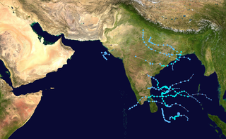
The 2005 North Indian Ocean cyclone season caused much devastation and many deaths in Southern India despite the storms’ weakness. The basin covers the Indian Ocean north of the equator as well as inland areas, sub-divided by the Arabian Sea and the Bay of Bengal. Although the season began early with two systems in January, the bulk of activity was confined from September to December. The official India Meteorological Department tracked 12 depressions in the basin, and the unofficial Joint Typhoon Warning Center (JTWC) monitored two additional storms. Three systems intensified into a cyclonic storm, which have sustained winds of at least 63 km/h (39 mph), at which point the IMD named them.

<span class="mw-page-title-main">Tropical Storm Vamei</span> Pacific and North Indian tropical cyclone in 2001

Tropical Storm Vamei was a Pacific tropical cyclone that formed at about 85 nautical miles from the equator—closer than any other tropical cyclone on record. The last storm of the 2001 Pacific typhoon season, Vamei developed on 26 December at 1.4° N in the South China Sea. It strengthened quickly and made landfall along extreme southeastern Peninsular Malaysia. Vamei rapidly weakened into a remnant low over Sumatra on 28 December, and the remnants eventually re-organized in the North Indian Ocean. Afterward, the storm encountered strong wind shear once again, and dissipated on 1 January 2002.

<span class="mw-page-title-main">Cyclone Agni</span> North Indian Ocean severe cyclonic storm in 2004

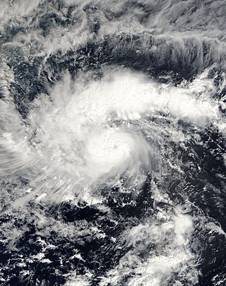
Severe Cyclonic Storm Agni was a tropical cyclone of the 2004 North Indian Ocean cyclone season notable for its record proximity to the equator. It was the second North Indian Ocean cyclone to receive a name, after Onil earlier in the year. Agni formed on November 28 well to the southwest of India in the Arabian Sea, and steadily intensified as it tracked northwestward. The Joint Typhoon Warning Center (JTWC) estimated peak 1 minute sustained winds of 120 km/h (75 mph), while the India Meteorological Department (IMD) estimated peak 3 minute sustained winds of 100 km/h (60 mph); the IMD is the official warning center for the north Indian Ocean. After peaking, it weakened due to wind shear, dry air, and cooler waters, and the JTWC issued its final advisory on December 3 as it approached the coast of Somalia. The remnants of Agni moved along the Somalian coastline until dissipating on December 5.

<span class="mw-page-title-main">2006 North Indian Ocean cyclone season</span> North Indian Ocean tropical cyclone season

The 2006 North Indian Ocean cyclone season had no bounds, but cyclones tend to form between April and December, with peaks in May and November. These dates conventionally delimit the period of each year when most tropical cyclones form in the northern Indian Ocean.

<span class="mw-page-title-main">1997–98 South-West Indian Ocean cyclone season</span> Cyclone season in the Southwest Indian Ocean

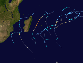
The 1997–98 South-West Indian Ocean cyclone season was fairly quiet and had the latest start in 30 years. The first tropical disturbance originated on January 16, although the first named storm, Anacelle, was not upgraded until February 8, a record late start. The last storm to dissipate was an unusually late tropical depression in late July. Many of the storms suffered from the effects of wind shear, which contributed to there being only one tropical cyclone – equivalent to a minimal hurricane. The season also occurred during a powerful El Niño.

<span class="mw-page-title-main">2004–05 South-West Indian Ocean cyclone season</span> Cyclone season in the Southwest Indian Ocean

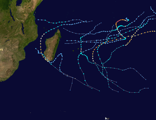
The 2004–05 South-West Indian Ocean cyclone season was a near average season, despite beginning unusually early on August 30 with the formation of an early-season tropical depression. Météo-France's meteorological office in Réunion (MFR) ultimately monitored 18 tropical disturbances during the season, of which 15 became tropical depressions. Two storms – Arola and Bento – formed in November, and the latter became the most intense November cyclone on record. Bento attained its peak intensity at a low latitude, and weakened before threatening land. Tropical Cyclone Chambo was the only named storm in December. In January, Severe Tropical Storm Daren and Cyclone Ernest existed simultaneously. The latter storm struck southern Madagascar, and five days later, Moderate Tropical Storm Felapi affected the same area; the two storms killed 78 people and left over 32,000 people homeless. At the end of January, Severe Tropical Storm Gerard existed as an unnamed tropical storm for 18 hours due to discrepancies between warning centers.

<span class="mw-page-title-main">2002–03 South-West Indian Ocean cyclone season</span> Cyclone season in the South-West Indian Ocean

The 2002–03 South-West Indian Ocean cyclone season was one of the longest lasting and the third-most active season in the South-West Indian Ocean. Storms during the season impacted the Mascarene Islands, Seychelles, Madagascar, and countries in south-eastern Africa. The season began early when an unnamed tropical storm struck Seychelles in September, becoming the most damaging storm there in 50 years. The next system, Atang, was the first named storm of the season, but was only a tropical depression; it was named due to the threat to an outer island of Mauritius. Atang later struck Tanzania in a climatologically unusual area in November, resulting in unconfirmed deaths of fishermen. The first named storm to reach tropical storm intensity was Boura, which brushed the Mascarene Islands with gusty winds and rainfall. In December, Cyclone Crystal threatened to strike Mauritius but instead veered eastward, and later, Tropical Storm Delfina lasted from late December through early January 2003. Delfina damaged or destroyed thousands of houses in Mozambique and Malawi, killing 54 people.

<span class="mw-page-title-main">2000–01 South-West Indian Ocean cyclone season</span> Cyclone season in the Southwest Indian Ocean

The 2000–01 South-West Indian Ocean cyclone season was a fairly quiet season with only five named storms, although there was an additional unnamed tropical storm and two subtropical cyclones with gale-force winds. It started early, with a tropical disturbance forming on August 1 – the first day of the cyclone year. However, the first named storm, Ando, was not named until January 2, which at the time was the 4th latest on record. Ando would become the most intense cyclone of the year, reaching peak winds of 195 km/h (121 mph) according to the Météo-France office (MFR) on Réunion, the official Regional Specialized Meteorological Center for the basin. The agency tracked storms south of the equator and west of 90°E to the east coast of Africa.

<span class="mw-page-title-main">2004 North Indian Ocean cyclone season</span> North Indian Ocean tropical cyclone season

The 2004 North Indian Ocean cyclone season was the first in which tropical cyclones were officially named in the basin. Cyclone Onil, which struck India and Pakistan, was named in late September. The final storm, Cyclone Agni, was also named, and crossed into the southern hemisphere shortly before dissipation. This storm became notable during its origins and became one of the storms closest to the equator. The season was fairly active, with ten depressions forming from May to November. The India Meteorological Department designated four of these as cyclonic storms, which have maximum sustained winds of at least 65 km/h (40 mph) averaged over three minutes. The Joint Typhoon Warning Center also issued warnings for five of the storms on an unofficial basis.

<span class="mw-page-title-main">2003 North Indian Ocean cyclone season</span> North Indian Ocean tropical cyclone season

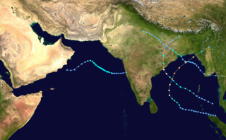
The 2003 North Indian Ocean cyclone season was the last season that tropical cyclones were not publicly labeled by India Meteorological Department (IMD). Also was mostly focused in the Bay of Bengal, where six of the seven depressions developed. The remaining system was a tropical cyclone that developed in the Arabian Sea in November, which was also the only system that did not affect land. There were three cyclonic storms, which was below the average of 4–6. Only one storm formed before the start of the monsoon season in June, although it was also the most notable. On May 10, a depression formed in the central Bay of Bengal, and within a few days became a very severe cyclonic storm. After it stalled, it drew moisture from the southwest to produce severe flooding across Sri Lanka, killing 254 people and becoming the worst floods there since 1947. Damage on the island totaled $135 million (2003 USD). The storm eventually made landfall in Myanmar on May 19. It is possible that the storm contributed to a deadly heat wave in India due to shifting air currents.

<span class="mw-page-title-main">2002 North Indian Ocean cyclone season</span> Cyclone season in the North Indian Ocean

The 2002 North Indian Ocean cyclone season was a below average season in terms of tropical cyclone formation. The season had no official bounds, but most storms formed in either May or after October. No depressions or storms formed during the monsoon season from July to September, the first such instance on record. There are two main seas in the North Indian Ocean – the Bay of Bengal to the east of the Indian subcontinent – and the Arabian Sea to the west of India. The official Regional Specialized Meteorological Centre in this basin is the India Meteorological Department (IMD), while the Joint Typhoon Warning Center (JTWC) releases unofficial advisories. An average of four to six storms form in the North Indian Ocean every season with peaks in May and November. Cyclones occurring between the meridians 45°E and 100°E are included in the season by the IMD.

<span class="mw-page-title-main">2000 North Indian Ocean cyclone season</span> Cyclone season in the North Indian ocean

The 2000 North Indian Ocean cyclone season was fairly quiet compared to its predecessor, with all of the activity originating in the Bay of Bengal. The basin comprises the Indian Ocean north of the equator, with warnings issued by the India Meteorological Department (IMD) in New Delhi. There were six depressions throughout the year, of which five intensified into cyclonic storms – tropical cyclones with winds of 65 mph (105 km/h) sustained over 3 minutes. Two of the storms strengthened into a Very Severe Cyclonic Storm, which has winds of at least 120 km/h (75 mph), equivalent to a minimal hurricane. The Joint Typhoon Warning Center (JTWC) also tracked storms in the basin on an unofficial basis, estimating winds sustained over 1 minute.

<span class="mw-page-title-main">1995 North Indian Ocean cyclone season</span> Cyclone season 1995 in the North Indian ocean

The 1995 North Indian Ocean cyclone season was below-average and was primarily confined to the autumn months, with the exception of three short-lived deep depressions in May. There were eight depressions in the basin, which is Indian Ocean north of the equator. The basin is subdivided between the Bay of Bengal and the Arabian Sea on the east and west coasts of India, respectively. Storms were tracked by the India Meteorological Department (IMD), which is the basin's Regional Specialized Meteorological Center, as well as the American-based Joint Typhoon Warning Center (JTWC) on an unofficial basis.

<span class="mw-page-title-main">1996 North Indian Ocean cyclone season</span> Cyclone season in the North Indian Ocean in 1996

The 1996 North Indian Ocean cyclone season featured several deadly tropical cyclones, with over 2,000 people killed during the year. The India Meteorological Department (IMD) – the Regional Specialized Meteorological Center for the northern Indian Ocean as recognized by the World Meteorological Organization – issued warnings for nine tropical cyclones in the region. Storms were also tracked on an unofficial basis by the American-based Joint Typhoon Warning Center, which observed one additional storm. The basin is split between the Bay of Bengal off the east coast of India and the Arabian Sea off the west coast. During the year, the activity was affected by the monsoon season, with most storms forming in June or after October.

<span class="mw-page-title-main">1998 North Indian Ocean cyclone season</span> Cyclone season in the North Indian ocean

The 1998 North Indian Ocean cyclone season was an active season in annual cycle of tropical cyclone formation. The season has no official bounds but cyclones tend to form between April and December. These dates conventionally delimit the period of each year when most tropical cyclones form in the northern Indian Ocean. There are two main seas in the North Indian Ocean—the Bay of Bengal to the east of the Indian subcontinent and the Arabian Sea to the west of India. The official Regional Specialized Meteorological Centre in this basin is the India Meteorological Department (IMD), while the Joint Typhoon Warning Center releases unofficial advisories. An average of four to six storms form in the North Indian Ocean every season with peaks in May and November. Cyclones occurring between the meridians 45°E and 100°E are included in the season by the IMD.

<span class="mw-page-title-main">1993 North Indian Ocean cyclone season</span> Cyclone season in the North Indian Ocean in 1993

The 1993 North Indian Ocean cyclone season was the least active on record in the basin, with only four tropical disturbances. There are two main seas in the North Indian Ocean – the Bay of Bengal to the east of the Indian subcontinent and the Arabian Sea to the west. The India Meteorological Department (IMD) issued advisories for the systems in its official capacity as the local Regional Specialized Meteorological Center, while the Joint Typhoon Warning Center also issued advisories for two of the storms on an unofficial basis. Of the five disturbances tracked by the IMD, two intensified into cyclonic storms.

<span class="mw-page-title-main">1994 North Indian Ocean cyclone season</span>

The 1994 North Indian Ocean cyclone season was a below-average year in which eight tropical cyclones affected seven countries bordering the North Indian Ocean. The India Meteorological Department tracks all tropical cyclones in the basin, north of the equator. The first system developed on March 21 in the Bay of Bengal, the first March storm in the basin since 1938. The second storm was the most powerful cyclone of the season, attaining maximum sustained winds of 215 km/h (135 mph) in the northern Bay of Bengal. Making landfall near the border of Bangladesh and Myanmar, the cyclone killed 350 people and left US$125 million in damage.

<span class="mw-page-title-main">1998–99 South-West Indian Ocean cyclone season</span> Cyclone season in the Southwest Indian Ocean

The 1998–99 South-West Indian Ocean cyclone season was a quiet season that had the fourth-lowest number of days with tropical storm or tropical cyclone activity. Most of the storms formed either in the Mozambique Channel or in the far eastern portion of the basin, with five storms crossing from the adjacent Australian basin east of 90° E. As a result, few storms impacted Madagascar, and none made landfall on the African continent. Throughout most of the season, there was below-normal sea surface temperatures in the Indian Ocean east of Madagascar. In February, typically the peak in activity, Réunion island recorded its highest average monthly pressure since 1953. Due to generally unfavorable conditions, there were only six tropical storms tracked by the Météo-France office (MFR) on Réunion. There were only two tropical cyclones – a storm with winds of at least 120 km/h (75 mph).

<span class="mw-page-title-main">2009 North Indian Ocean cyclone season</span> North Indian Ocean tropical cyclone season

The 2009 North Indian Ocean cyclone season was an event in the annual cycle of tropical cyclone formation. The North Indian Ocean cyclone season has no official bounds, but cyclones tend to form between April and December, with peaks in May and November. These dates conventionally delimit the period of each year when most tropical cyclones form in the northern Indian Ocean.

<span class="mw-page-title-main">2000 South India cyclone</span> Cyclonic Storm in the North Indian ocean in 2000

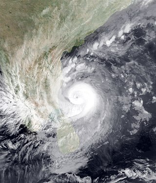
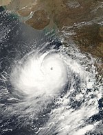
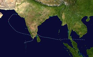
The 2000 South Indian Cyclone was the strongest, most intense tropical cyclone of the fairly-quiet 2000 North Indian Ocean cyclone season. The fifth cyclone, and the fourth named storm, Extremely Severe Cyclonic Storm BOB 05 started as an upper-level low over the Andaman Sea on November 24. On early November 26, the group of thunderstorms was classified as a depression by the IMD. The system slowly began to organize, and late on November 26 the JTWC named it as Tropical Cyclone 03B. By November 28, a 20 km (12 mi)-wide eye was developing, prompting the JTWC to upgrade the storm to the equivalent of a minimal hurricane with winds of 120 km/h (75 mph). By comparison, the IMD estimated peak winds of 190 km/h (120 mph). Wind shear in the region prevented further strengthening, and the storm weakened slightly before making landfall on November 29 in eastern India near Cuddalore. A station there recorded a pressure of 983 mbar (29.0 inHg).

References

  1. 1 2 3 4 5 6 7 8 9 10 11 12 13 14 15 16 17 18 19 20 21 22 23 24 25 26 27 28 29 30 31 32 "Cyclones and depressions over north Indian Ocean during 2001" (PDF). MAUSAM. 53 (3). July 2002. Archived from the original (PDF) on 5 March 2016. Retrieved 25 August 2016.
  2. 1 2 3 Annual Summary of the Global Tropical Cyclone Season 2001 (DOC) (Report). World Meteorological Organization. Retrieved 2015-05-16.
  3. 1 2 3 Gary Padgett (2001-07-01). "Monthly Tropical Weather Summary for May 2001". Typhoon2000. Retrieved 2015-05-16.
  4. 1 2 Kenneth R. Knapp; Michael C. Kruk; David H. Levinson; Howard J. Diamond; Charles J. Neumann (2010). 2001 Missing (2001141N14068). The International Best Track Archive for Climate Stewardship (IBTrACS): Unifying tropical cyclone best track data (Report). Bulletin of the American Meteorological Society. Archived from the original on 2015-12-08. Retrieved 2015-05-16.
  5. Sekhar Chandra Dutta (2012). Improving Earthquake and Cyclone Resistance of Structures: guidelines for the Indian subcontinent. The Energy and Resources Institute. p. 171. ISBN   978-81-7993-302-2.
  6. "India cyclone weakening but still 'a threat'". CNN. Reuters. 2001-05-26. Retrieved 2015-05-16.
  7. "Cyclone threatens India, Pakistan". CNN. Reuters. 2001-05-25. Retrieved 2015-05-16.
  8. Harish Desai (2001-05-25). "Cyclone weakens, but 950 fishermen missing in western India". Associated Press.  via Lexis Nexis (subscription required)
  9. 1 2 3 4 5 "Monthly Global Tropical Cyclone Summary September 2001". Gary Padgett. 2001. Archived from the original on 2013-01-17. Retrieved 2014-05-07.
  10. Kenneth R. Knapp; Michael C. Kruk; David H. Levinson; Howard J. Diamond; Charles J. Neumann (2010). 2001 Missing (2001267N17070). The International Best Track Archive for Climate Stewardship (IBTrACS): Unifying tropical cyclone best track data (Report). Bulletin of the American Meteorological Society. Archived from the original on 2016-07-07. Retrieved 2015-05-07.
  11. 1 2 3 "Monthly Global Tropical Cyclone Summary October 2001". Gary Padgett. 2001. Retrieved 2015-05-12.
  12. Kenneth R. Knapp; Michael C. Kruk; David H. Levinson; Howard J. Diamond; Charles J. Neumann (2010). 2001 Missing (2001288N14084). The International Best Track Archive for Climate Stewardship (IBTrACS): Unifying tropical cyclone best track data (Report). Bulletin of the American Meteorological Society. Archived from the original on 2016-03-05. Retrieved 2015-05-15.
  13. 1 2 3 "Monthly Global Tropical Cyclone Summary November 2001". Gary Padgett. 2002. Retrieved 2014-05-15.
  14. 1 2 3 4 5 6 International Federation of Red Cross And Red Crescent Societies (2001-11-09). India floods 2001 appeal No. 21/01 operations update No. 6 (Report). ReliefWeb. Retrieved 2015-05-16.
  15. International Federation of Red Cross And Red Crescent Societies (2001-12-28). India floods 2001 appeal No. 21/01 operations update No. 7 (Report). ReliefWeb. Retrieved 2015-05-16.
  16. 1 2 3 "Monthly Global Tropical Cyclone Summary June 2001". Gary Padgett. 2001. Retrieved 2014-05-01.
  17. Kenneth R. Knapp; Michael C. Kruk; David H. Levinson; Howard J. Diamond; Charles J. Neumann (2010). 2001 Missing (2001163N20087). The International Best Track Archive for Climate Stewardship (IBTrACS): Unifying tropical cyclone best track data (Report). Bulletin of the American Meteorological Society. Archived from the original on 2016-03-05. Retrieved 2014-10-20.
  18. "Monthly Global Tropical Cyclone Summary December 2001". Gary Padgett. 2002. Archived from the original on 2013-01-17. Retrieved 2014-05-15.
  19. Kenneth R. Knapp; Michael C. Kruk; David H. Levinson; Howard J. Diamond; Charles J. Neumann (2010). 2001 Vamei (2001361N01106). The International Best Track Archive for Climate Stewardship (IBTrACS): Unifying tropical cyclone best track data (Report). Bulletin of the American Meteorological Society. Archived from the original on 2016-03-05. Retrieved 2015-05-15.