Cyclone Gonu

Last updated

Map key
  Tropical depression (≤38 mph, ≤62 km/h)
  Tropical storm (39–73 mph, 63–118 km/h)
  Category 1 (74–95 mph, 119–153 km/h)
  Category 2 (96–110 mph, 154–177 km/h)
  Category 3 (111–129 mph, 178–208 km/h)
  Category 4 (130–156 mph, 209–251 km/h)
  Category 5 (≥157 mph, ≥252 km/h)
  Unknown
Storm type
Disc Plain black.svg Tropical cyclone
Solid black.svg Subtropical cyclone
ArrowUp.svg Extratropical cyclone, remnant low, tropical disturbance, or monsoon depression

Toward the end of May 2007, the monsoon trough spawned a low-pressure area in the eastern Arabian Sea. [2] By May 31, an organized tropical disturbance was located about 645 km (400 mi) south of Mumbai, India, with cyclonic convection, or thunderstorm activity, and a well-defined mid-level circulation. The disturbance initially lacked a distinct low-level circulation; instead it consisted of strong divergence along the western end of a surface trough of low pressure. [3] A favorable upper-level environment allowed convection to improve, [4] and by late on June 1, the system developed to the extent that the India Meteorological Department (IMD) classified it as a depression. [5] It tracked westward along the southwestern periphery of a mid-level ridge over southern India. Convection continued to organize, and early on June 2, the Joint Typhoon Warning Center (JTWC) classified the storm as Tropical Cyclone 02A, about 685 km (425 mi) southwest of Mumbai. [6]

Upon first forming, the system contended with the entrainment of dry air to the northwest of the storm, which was expected to limit intensification. [6] The storm steadily intensified, and early on June 2 the IMD upgraded it to deep depression status. [7] Later in the day the IMD classified the system as Cyclonic Storm Gonu about 760 km (470 mi) southwest of Mumbai, India. [8] As a mid-latitude trough developed over Pakistan, Gonu turned to the north and northeast, [9] though it resumed a westward track after ridging built to the north of the storm. [10] With a solid area of intense convection, it rapidly intensified to attain severe cyclonic status early on June 3, [11] and with good outflow the JTWC upgraded it to the equivalent of a minimal hurricane. [12] The dry air ultimately had a smaller impact on the intensification than previously estimated. A well-defined eye developed in the center of convection, and after moving over a local increase in ocean heat content, Gonu rapidly deepened. [13]

Cyclone Gonu off the coast of Oman on June 5 TC Gonu 05 June 07 0635Z.jpg
Cyclone Gonu off the coast of Oman on June 5

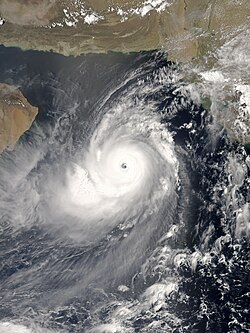
Late on June 3, the IMD upgraded the storm to Very Severe Cyclonic Storm Gonu. [14] With warm waters, [15] low amounts of vertical wind shear, and favorable upper-level outflow, Gonu strengthened further to attain peak 1-min sustained winds of 270 km/h (170 mph) [16] and gusts to 315 km/h (195 mph), about 285 km (175 mi) east-southeast of Masirah Island on the coast of Oman. [17] The IMD upgraded it to Super Cyclonic Storm Gonu late on June 4, with peak 3-min sustained winds reaching 240 km/h (150 mph) and an estimated pressure of 920  mbar. [18] This made it the first super cyclonic storm in the Arabian Sea on record. [15]

After the storm maintained peak winds for about six hours, the IMD downgraded Gonu to very severe cyclonic storm status late on June 4. [2] Gonu's eye became cloud-filled and ragged, and the cyclone gradually weakened due to cooler water temperatures and drier air as it approached the Arabian Peninsula. [19] Due to land interaction with Oman, the inner core of deep convection rapidly weakened, and over a period of 24 hours the intensity decreased by 95 km/h (60 mph). [20] According to the IMD, Cyclone Gonu crossed the easternmost tip of Oman near Muscat early on June 6, with winds of 143 km/h (89 mph). [2] Although the winds continued to gradually decrease, overall organization increased slightly in the hours prior to landfall; Gonu maintained a well-defined low-level structure with a weak eye. [21]

After emerging into the Gulf of Oman, the cyclone briefly re-intensified slightly, [22] possibly due to the warm waters. [15] However, increasing wind shear and entrainment of dry air from the Arabian Peninsula continued to remove deep convection from its eastern semicircle. [23] On June 6, the cyclone turned to the north-northwest, [24] and later that day the JTWC downgraded Gonu to tropical storm status. [25] The IMD followed suit by downgrading Gonu to severe cyclonic storm status, and later to cyclonic storm status early on June 7. [26] [27] Gonu crossed the Makran coast in Iran six hours later, and the IMD stopped issuing advisories on the cyclone. [28] This made it the first tropical cyclone on record to hit the country since 1898. After landfall, Gonu persisted as a remnant low over Iran through June 8. [15]

Preparations

The Oman Chairman of the National Committee for Civil Defence, General Malek Bin Sulaiman Al Ma'amari, remarked the nation had already developed a contingency plan, which included the activation of army and police personnel after the storm's passage. Significant damage was expected, especially in northeastern areas, along with up to 150 mm (6 in) of rainfall and very strong winds. [29] Officials recommended citizens evacuate from potentially affected areas, [30] and about 7,000 people were forced to leave Masirah Island due to the threat of high surf and strong winds. [31] Overall, more than 20,000 people evacuated to emergency shelters. [32] A state of emergency was declared for the nation. [30] The Omani national weather service warned that the cyclone was expected to be worse than the destructive cyclone that hit Masirah Island in 1977. [33] The Mina al Fahal oil terminal closed for over three days due to the threat of the storm. [34] Omani officials closed government offices for two days and declared a five-day-long national holiday. Most businesses near the coastline were closed prior to the announcement. [35] The nation's Civil Aviation Authority, along with Muscat International Airport (then named as "Seeb International Airport") and Salalah International Airport canceled all flights at 20:00  UTC on June 5. [36]

Map showing rainfall totals around the Gulf of Oman between May 31 and June 7, 2007. The red areas show where rainfall exceeded 200 mm (8 inches). Gonu rainfall.jpg
Map showing rainfall totals around the Gulf of Oman between May 31 and June 7, 2007. The red areas show where rainfall exceeded 200 mm (8 inches).

In Saudi Arabia and the United Arab Emirates, both members of OPEC, no official warnings had been issued due to Gonu. The storm was not expected to disrupt oil supplies from these two nations. [30] However, oil prices rose early on June 5 because of concerns of disruptions caused by Gonu, as well as the threat of nationwide strikes in Nigeria, Africa's biggest oil producer. Crude oil for July delivery rose $1.13, or 1.7 percent, to $66.21 Monday on the New York Mercantile Exchange, the highest close in 15 days. Futures reached $66.48, the highest intraday price since April 30. The contract was at $65.95 a barrel, down 26 cents, in after-hours electronic trading at 9:43 a.m. Tuesday in Singapore. [37] Tom Kloza, chief oil analyst at the Oil Price Information Service, said he doubted the increase could be attributed to Gonu. "I don't know if you can really attribute any of the gain to the cyclone", he said. "It's an excuse, as opposed to a reason, for the rise in prices." [38]

In Pakistan, officials recommended fishermen remain within 50 km (30 mi) of the coastline, due to anticipated rough waves in the open ocean. [39] Naval authorities in the United States warned ships to avoid the cyclone in the Arabian Sea. [40]

The Iran Department of Meteorology declared storm warnings for the country's southeastern coastline; the agency anticipated moderate to severe precipitation and gusty winds. [41] Prior to the arrival of the cyclone, about 40,000 people, [42] including around 4,000 students at the International University of Chabahar, [43] evacuated coastal areas of the country to at least 1 km (0.6 mi) inland. [42] All flights in and out of the Konarak Airport were canceled during a 48-hour period. Additionally, all hospitals in Sistan and Baluchestan Province were put on red alert. [43] The Iran chapter of the Red Cross advanced the delivery of necessary relief supplies. [44]

Impact

Road damage in Muscat, Oman Gonu Damage in Qurum Beach 1.JPG
Road damage in Muscat, Oman

Across its path, Cyclone Gonu caused heavy damage and many fatalities. [2] About seven hours before passing near the northeastern Oman coastline, Gonu began affecting the country with rough winds and heavy precipitation; rainfall totals reached 610 mm (24 in) near the coast. [45] [46] Gonu produced strong waves along much of the coastline, [45] leaving many coastal roads flooded. [41] There was a 5.1 meter (17 foot) storm surge and a 200 m (660 ft) incursion of seawater inland at Ras al-Hadd; other areas along the coast had similar levels. [47]

Oman

Strong winds knocked out power and telephone lines across the eastern region of the country, leaving thousands isolated until the lines were repaired hours later. The cyclone caused extensive damage along the coastline, including in the city of Sur and the village of Ras al Hadd at the easternmost point of the Omani mainland. [48] In Muscat, winds reached 100 km/h (60 mph), leaving the capital city without power. Strong waves and heavy rainfall flooded streets and some buildings. Police workers in the city sent text messages to keep people away from flooded streets to prevent electrocutions. Little damage was reported to the oil fields of the nation. [32] The liquefied natural gas terminal in Sur, which handles 10 million tonnes of gas each year, was badly hit by the storm and could not be operated. [49] Overall, the cyclone killed 50 people in the country; by the fourth day after it struck the country, 27 people had been reported missing. [2] Around 20,000 people were affected, [50] and damage in the country was estimated at around $4.2 billion (2007 USD). [2]

United Arab Emirates

Super Cyclonic Storm Gonu
Gonu 2007-06-04 0900Z.jpg
Gonu near peak intensity on June 4
Costliest known North Indian cyclones
RankCycloneSeasonDamage
(2023 USD)
1 Nargis 2008 $18.3 billion
2 Amphan 2020 $16.6 billion
3 Fani 2019 $9.65 billion
4 BOB 06 1999 $8.12 billion
5 Gonu 2007 $6.47 billion
6 Phailin 2013 $5.57 billion
7 Hudhud 2014 $4.61 billion
8 Vardah 2016 $4.29 billion
9 ARB 02 1998 $5.61 billion
10 Sidr 2007 $3.5 billion

Fierce waves pushed large amounts of water to coastal areas in Fujairah of the United Arab Emirates, forcing roads to be closed and traffic diverted. Civil defence and police were on duty to manage the road closures, while municipal workers pumped the excess water off the roads. The road connecting Kalba and Fujairah was closed due to the road being submerged by water. [51] The waves along the coastline were reported to be 10 m (32 ft) high, which destroyed about a dozen fishing boats. About 300 boats were moved from the water or emptied of equipment, [52] and overall damage to the port of Fujairah was reported as severe. A boat sank by the port, leaving its ten passengers missing. [53]

Iran

Upon striking Iran, Gonu dropped moderate to heavy rainfall, including 74 mm (2.91 in) in the city of Chabahar. [42] Winds reached 111 km/h (69 mph), [32] which caused power outages and damaged some homes made of clay; [42] the power outage led to some fires across the city. The rainfall flooded at least 40 houses, [43] and resulted in the temporary closure of several major roads. [32] Gonu produced a storm tide of 2 m (6.5 ft) in some locations, [54] with many homes near the coastline receiving damage. [34] In Jask, heavy rainfall overflowed a river, killing three people in a vehicle caught in the water. [55] Flooding from the rainfall also destroyed a dam in Nikshahr County. [54] Throughout the country, the cyclone caused 28 deaths, [2] including 20 from drowning; damage in Iran was estimated at 2 billion (2007  IRR, $216 million 2007 USD). [54]

Pakistan

Gonu caused strong gusty winds and torrential rainfall along Pakistan's Arabian Sea coast from Karachi to Gwadar. [56] The cyclone was reported to have sunk a number of boats off the eastern coast of Gwadar. [57] It was feared that fishing launches that had ventured into the open sea may have been stranded. At least three houses and one school were destroyed and 210 anchored fishing boats were badly damaged anchored in the coastal town of Sar Bandar in Baluchistan province [58]

Aftermath

Flipped car and flooding on a street in Muscat, Oman Oman Gonu1.JPG
Flipped car and flooding on a street in Muscat, Oman
Satellite animation showing the life cycle of Gonu

Flights to and from Muscat resumed after three days while Fujairah reopened on June 7 after it was closed the day before. [49] The cyclone caused little impact to oil facilities along its path; after the initial price rises, oil dropped over US$2 per barrel as a result. [59] Across the northern Arabian Sea, the passage of Gonu produced stronger winds and significant upwelling  – an oceanographic phenomenon that involves the replacement of the nutrient-depleted surface water with deeper nutrient-rich water; the passage caused a significant increase in phytoplankton. [60] Additionally, the cyclone delayed the arrival of the Indian Ocean south-west monsoon in the Western Ghats in India. [61]

In Oman, production of desalinated water was interrupted, as both of Oman's desalination plants failed. The first, Ghubrah, lost supplies of natural gas, halting production; while the second, Barka, sustained a damaged switchgear due to flooding. These plants provided water to Muscat's 631,000 residents and surrounding areas, triggering severe water shortages across eastern Oman. To rectify the situation, officials used water tanks. The water returned to near normal in five days, as the two plants returned to service. Additionally, electricians worked quickly to repair the power outages across the region. [62] Five days after Gonu hit, utilities were restored to most of Muscat and the coastal provinces. The Omani army assisted residents in returning to their houses. Even though the Omani government did not request any international aid, the United States offered assistance through naval ships in the area; this was eventually rejected. [46] The country lost an estimated $200 million (2007 USD) in oil exports. [63] In the months after the storm, the government allocated funds for the removal of debris and trees, as well as restoration of roads in tourist areas. [64] Additionally, the National Committee for Civil Defence set up 139 buildings to provide temporary housing for 8,192 people. Services such as water and electricity were gradually restored, and people returned to their homes. By two weeks after the storm's passage, most of those remaining in shelters were from Qurayat, one of the most severely affected villages. [65]

After the passage of the cyclone, the Iran chapter of the Red Cross and its volunteers worked in conjunction with the military to distribute relief supplies to villages using trucks and helicopters. The branch in Sistan and Baluchestan Province distributed over 10,000 blankets, 1,300 tents, 400 clothing items, 82,000 loaves of bread, and 87,000 bottles of water to affected citizens. [44] In total, 61,558 families received aid from the Red Cross in Iran. [66] The Iranian government provided monetary relief to the affected people. Officials worked to restore roads, bridges, and power systems in the affected areas, although repairs were more difficult in some locations; by a week after the storm, several villages remained surrounded by floodwaters. [67]

Records

Cyclone Gonu set several intensity records. When it became a very severe cyclonic storm on June 3, Gonu became the strongest tropical cyclone on record in the Arabian Sea. [14] [68] It was the only super cyclonic storm, which is a tropical cyclone with 3-minute sustained winds of at least 220 km/h (135 mph), in the region, until Cyclone Kyarr 12 years later. [2] The JTWC estimated peak 1-minute sustained winds of 270 km/h (170 mph), the highest 1-minute sustained winds of any cyclone in the North Indian Ocean until Cyclone Fani 12 years later. [16] On June 6, Gonu made landfall in extreme eastern Oman with winds of 150 km/h (95 mph), [2] making it the strongest tropical cyclone on record to strike the Arabian Peninsula. [69] With a damage total of $4.2 billion (2007 USD) and 50 deaths, [2] Gonu became the worst natural disaster on record in Oman. [68] Additionally, the storm was only the second cyclonic storm on record to strike Iran, with the other one doing so on June 4, 1898. [2]

See also

Related Research Articles

<span class="mw-page-title-main">North Indian Ocean tropical cyclone</span>

In the Indian Ocean north of the equator, tropical cyclones can form throughout the year on either side of the Indian subcontinent, although most frequently between April and June, and between October and December.

<span class="mw-page-title-main">2007 North Indian Ocean cyclone season</span>

The 2007 North Indian Ocean cyclone season was one of the most active North Indian Ocean cyclone seasons on record. The North Indian Ocean cyclone season has no official bounds, but cyclones tend to form between April and December, with peaks in May and November. These dates conventionally delimit the period of each year when most tropical cyclones form in the northern Indian Ocean.

<span class="mw-page-title-main">Timeline of the 2007 North Indian Ocean cyclone season</span>

Below is a timeline of the 2007 North Indian Ocean cyclone season, documenting major events with regards to tropical cyclone formation, strengthening, weakening, landfall, extratropical transition, as well as dissipation. The 2007 North Indian Ocean cyclone season was an ongoing event in the annual cycle of tropical cyclone formation.

<span class="mw-page-title-main">1977 North Indian Ocean cyclone season</span>

The 1977 North Indian Ocean cyclone season was part of the annual cycle of tropical cyclone formation. The season has no official bounds but cyclones tend to form between April and December. These dates conventionally delimit the period of each year when most tropical cyclones form in the northern Indian Ocean. There are two main seas in the North Indian Ocean—the Bay of Bengal to the east of the Indian subcontinent and the Arabian Sea to the west of India. The official Regional Specialized Meteorological Centre in this basin is the India Meteorological Department (IMD), while the Joint Typhoon Warning Center (JTWC) releases unofficial advisories. An average of five tropical cyclones form in the North Indian Ocean every season with peaks in May and November. Cyclones occurring between the meridians 45°E and 100°E are included in the season by the IMD.

<span class="mw-page-title-main">2001 Gujarat cyclone</span> North Indian cyclone in 2001

The 2001 Gujarat cyclone was the third strongest tropical cyclone, in terms of barometric pressure, to form in the Arabian Sea on record; only Cyclones Gonu in 2007 and Kyarr in 2019 were stronger. The storm originated from a tropical disturbance that formed east of Somalia on May 18. Over the following few days, the system gradually organized into a tropical depression. Tracking eastward, towards the coastline of southwestern India, the storm slowly intensified. Shortly before reaching shore, the system turned north and later west, away from land. After taking this turn, the storm intensified into a very severe cyclonic storm, attaining its peak intensity on May 24 with winds of 215 km/h and a barometric pressure of 932 mbar (hPa). At the time, this ranked the cyclone as the strongest known storm in the Arabian Sea.

<span class="mw-page-title-main">Cyclone Phet</span> North Indian cyclone in 2010

Very Severe Cyclonic Storm Phet was a powerful tropical cyclone that made landfall on Oman, Western India, and Pakistan. The third named cyclone of the 2010 cyclone season, Phet developed in the Arabian Sea on May 31 to the west of India. With conducive environmental conditions, the storm intensified to reach peak sustained winds of 155 km/h (95 mph) on June 2, based on analysis by the India Meteorological Department (IMD). On the next day, Phet dropped heavy rainfall while moving across eastern Oman, with a peak of 603 mm (23.7 in) in Qurayyat. The rains flooded arid areas and collected into wadis – normally dry river beds. Thousands of homes were wrecked across Oman. There were 24 fatalities in the country, and damage was estimated at US$780 million.

<span class="mw-page-title-main">1977 Oman cyclone</span> North Indian cyclone in 1977

The 1977 Oman cyclone was the deadliest tropical cyclone on record to strike Oman. The storm formed off the west coast of India in the Arabian Sea, and curved westward to reach peak winds of 110 km/h (68 mph). The storm struck Masirah Island and later southern Oman on June 13, before dissipating the next day over Saudi Arabia. Producing wind gusts to 230 km/h (140 mph), the storm was the strongest cyclone on record to hit the Arabian Peninsula until Cyclone Gonu hit in 2007. About 95% of Marisah Island was damaged by the strong winds, including much of the military base. The cyclone dropped 430.6 mm (16.95 in) of rainfall over a 24-hour period on Marisah, which was the highest daily total in the country as of 2003. Overall, the storm killed at least 105 people and left 50,000 homeless.

<span class="mw-page-title-main">Cyclone Keila</span> North Indian cyclone in 2011

Cyclonic Storm Keila was the first named storm of the 2011 North Indian Ocean cyclone season. A weak system for much of its duration, Keila developed in the western Arabian Sea in late October 2011, amid an area of marginally favorable conditions. On November 2, it briefly organized enough to be classified as a cyclonic storm, which has maximum sustained winds of at least 65 km/h (40 mph). Given the name Keila by the India Meteorological Department (IMD), the storm quickly moved ashore southern Oman near Salalah, and weakened while meandering over the country. The remnants soon after moved offshore, dissipating on November 4.

<span class="mw-page-title-main">Cyclone Nilofar</span> North Indian cyclone in 2014

Extremely Severe Cyclonic Storm Nilofar was, at the time, the third-strongest cyclone in the Arabian Sea. In late October 2014, it reached peak maximum sustained winds estimated between 205 km/h (125 mph) and 215 km/h (130 mph). The India Meteorological Department (IMD) named it Nilofar; the name refers to the water lily, and was suggested by Pakistan. The western fringes of the storm caused flash flooding in northeastern Oman, killing four people.

<span class="mw-page-title-main">Cyclone Chapala</span> North Indian cyclone in 2015

Extremely Severe Cyclonic Storm Chapala was a powerful tropical cyclone that caused moderate damage in Somalia and Yemen during November 2015. Chapala was the third named storm of the 2015 North Indian Ocean cyclone season. It developed as a depression on 28 October off western India, and strengthened a day later into a cyclonic storm. Chapala then rapidly intensified amid favorable conditions. On 30 October, the India Meteorological Department (IMD) estimated that Chapala attained peak three-minute sustained winds of 215 km/h (135 mph). The American-based Joint Typhoon Warning Center (JTWC) estimated sustained winds of 240 km/h (150 mph), making Chapala among the strongest cyclones on record in the Arabian Sea. After peak intensity, Chapala skirted the Yemeni island of Socotra on 1 November, becoming the first hurricane-force storm there since 1922. High winds and heavy rainfall resulted in an island-wide power outage, and severe damage was compounded by Cyclone Megh, which struck Yemen a week later. Chapala means 'scrutiny' in Bengali.

<span class="mw-page-title-main">2016 North Indian Ocean cyclone season</span>

The 2016 North Indian Ocean cyclone season was an event in the annual cycle of tropical cyclone formation. It was the deadliest season since 2010, killing more than 400 people. The season was an average one, seeing four named storms, with one further intensifying into a very severe cyclonic storm. The first named storm, Roanu, developed on 19 May while the season's last named storm, Vardah, dissipated on 18 December. The North Indian Ocean cyclone season has no official bounds, but cyclones tend to form between April and December, with the two peaks in May and November. These dates conventionally delimit the period of each year when most tropical cyclones form in the northern Indian Ocean.

<span class="mw-page-title-main">2018 North Indian Ocean cyclone season</span>

The 2018 North Indian Ocean cyclone season was one of the most active North Indian Ocean cyclone seasons since 1992, with the formation of fourteen depressions and seven cyclones. The North Indian Ocean cyclone season has no official bounds, but cyclones tend to form between April and December, with the two peaks in May and November. These dates conventionally delimit the period of each year when most tropical cyclones form in the northern Indian Ocean.

<span class="mw-page-title-main">2019 North Indian Ocean cyclone season</span>

The 2019 North Indian Ocean cyclone season was the second most active North Indian Ocean cyclone season on record in terms of cyclonic storms, the 1992 season was more active according to the Joint Typhoon Warning Center. The season featured 12 depressions, 11 deep depressions, 8 cyclonic storms, 6 severe cyclonic storms, 6 very severe cyclonic storms, 3 extremely severe cyclonic storms, and 1 super cyclonic storm, Kyarr, the first since Cyclone Gonu in 2007. Additionally, it also became the third-costliest season recorded in the North Indian Ocean, only behind the 2020 and 2008 seasons.

<span class="mw-page-title-main">2020 North Indian Ocean cyclone season</span>

The 2020 North Indian Ocean cyclone season was the costliest North Indian Ocean cyclone season on record, mostly due to the devastating Cyclone Amphan. The North Indian Ocean cyclone season has no official bounds, but cyclones tend to form between April and November, with peaks in late April to May and October to November. These dates conventionally delimit the period of each year when most tropical cyclones form in the northern Indian Ocean. The season began on May 16 with the designation of Depression BOB 01 in the Bay of Bengal, which later became Amphan. Cyclone Amphan was the strongest storm in the Bay of Bengal in 21 years and would break Nargis of 2008's record as the costliest storm in the North Indian Ocean. The season concluded with the dissipation of Cyclone Burevi on December 5. Overall, the season was slightly above average, seeing the development of five cyclonic storms.

<span class="mw-page-title-main">Cyclone Mekunu</span> Category 3 North Indian Cyclone in 2018

Extremely Severe Cyclonic Storm Mekunu was the strongest storm to strike Oman's Dhofar Governorate since 1959. The second named storm of the 2018 North Indian Ocean cyclone season, Mekunu developed out of a low-pressure area on May 21. It gradually intensified, passing east of Socotra on May 23 as a very intense tropical cyclone. On May 25, Mekunu reached its peak intensity. The India Meteorological Department estimated 10 minute sustained winds of 175 km/h (110 mph), making Mekunu an extremely severe cyclonic storm. The American-based Joint Typhoon Warning Center estimated slightly higher 1 minute winds of 185 km/h (115 mph). While at peak intensity, Mekunu made landfall near Raysut, Oman, on May 25. The storm rapidly weakened over land, dissipating on May 27.

<span class="mw-page-title-main">2021 North Indian Ocean cyclone season</span>

The 2021 North Indian Ocean cyclone season was an average season, the North Indian Ocean cyclone season has no official bounds, but cyclones tend to form between April and December, peaking between May and November. These dates conventionally delimit the period of each year when most tropical cyclones form in the northern Indian Ocean. The season began on April 2, when a depression designated as BOB 01 was formed in the north Andaman Sea and quickly made landfall in Myanmar. The basin remained quiet for over a month before Cyclone Tauktae formed. It rapidly intensified into an extremely severe cyclonic storm before making landfall in Gujarat, become the strongest storm ever to strike that state since the 1998 Gujarat cyclone. Later that month, BOB 02 formed and later strengthened into Cyclone Yaas. Yaas rapidly intensified into a very severe cyclonic storm before making landfall in northwestern Odisha. The season's strongest tropical cyclone was Cyclone Tauktae, with maximum wind speeds of 185 km/h (115 mph) and a minimum barometric pressure of 950 hPa (28.05 inHg).

<span class="mw-page-title-main">Cyclone Luban</span> Category 2 Indian ocean cyclone in 2018

Very Severe Cyclonic Storm Luban was the third tropical cyclone to affect the Arabian Peninsula during the 2018 North Indian Ocean cyclone season, after cyclones Sagar and Mekunu in May. Luban developed on October 6 in the central Arabian Sea, and for much of its duration, maintained a general west-northwestward trajectory. On October 10, the India Meteorological Department (IMD) upgraded Luban to a very severe cyclonic storm – equivalent to a Category 1 hurricane – and estimated maximum sustained winds of 140 km/h (85 mph). The storm made landfall on October 14 in eastern Yemen, as a cyclonic storm. The storm quickly weakened over the dry, mountainous terrain of the Arabian Peninsula, before dissipating on October 15.

<span class="mw-page-title-main">Cyclone Kyarr</span> North Indian cyclone in 2019

Super Cyclonic Storm Kyarr was an extremely powerful tropical cyclone that became the first super cyclonic storm in the North Indian Ocean since Gonu in 2007. It was also the second strongest tropical cyclone in the Arabian Sea and one of the most intense tropical cyclones in North Indian Ocean history. The seventh depression, fifth named cyclone, and the first, and only Super Cyclonic Storm of the annual season, Kyarr developed from a low-pressure system near the Equator. The system organized itself and intensified to a tropical storm on October 24 as it moved eastwards. The storm underwent rapid intensification and reached Super Cyclonic Storm status on October 27, as it turned westward. On that same day, Kyarr peaked as a Super Cyclonic Storm, with maximum 3-minute sustained winds of 240 km/h (150 mph), maximum 1-minute sustained winds of 250 km/h (155 mph), and a minimum central pressure of 922 millibars (27.2 inHg), making the system a high-end Category 4-equivalent tropical cyclone. Afterward, Kyarr gradually began to weaken, while curving westward, and then turning to the southwest. On October 31, Kyarr weakened into a Deep Depression, before turning southward on November 2, passing just to the west of Socotra. Kyarr degenerated into a remnant low later that day, before dissipating on November 3, just off the coast of Somalia.

<span class="mw-page-title-main">Cyclones Gulab and Shaheen</span> North Indian Ocean cyclones in 2021

Cyclonic Storm Gulab and Severe Cyclonic Storm Shaheen were two tropical cyclones that caused considerable damage to South and West Asia during the 2021 North Indian Ocean cyclone season. Gulab impacted India and Pakistan, while Shaheen impacted Iran, Oman and the United Arab Emirates. Gulab was the third named storm of the 2021 North Indian Ocean cyclone season, as well as the fourth named storm of the season after its reformation in the Arabian Sea as Shaheen. The cyclone's origins can be traced back to a low-pressure area situated over the Bay of Bengal on September 24. The Pakistan Meteorological Department named this new cyclone Gulab.On September 26, Gulab made landfall in India's Andhra Pradesh but weakened overland, before degenerating into a remnant low on September 28. The system continued moving westward, emerging into the Arabian Sea on September 29, before regenerating into a depression early on September 30. Early on October 1, the system restrengthened into a Cyclonic Storm, which the IMD named Shaheen. The system gradually strengthened as it entered the Gulf of Oman. While slowly moving westward, the storm turned southwestward, subsequently making an extremely rare landfall in Oman on October 3, as a Category 1-equivalent cyclone. Shaheen then rapidly weakened, before dissipating the next day.

References

  1. "NASA Earth Observatory: Tropical Cyclone Gonu". NASA. June 4, 2007. Archived from the original on September 27, 2014. Retrieved January 2, 2014.
  2. 1 2 3 4 5 6 7 8 9 10 11 India Meteorological Department (January 2008). "Report on Cyclonic Disturbances over North Indian Ocean during 2007". Archived from the original on November 26, 2008. Retrieved April 18, 2010.
  3. Delta Forecast Team (May 31, 2007). "May 31 Significant Tropical Weather Advisory for the North Indian Ocean". Joint Typhoon Warning Center. Archived from the original on May 22, 2024. Retrieved June 4, 2007.
  4. Charlie Forecast Team (June 1, 2007). "June 1 Significant Tropical Weather Advisory for the North Indian Ocean". Joint Typhoon Warning Center. Archived from the original on May 22, 2024. Retrieved June 4, 2007.
  5. India Meteorological Department (June 2, 2007). "June 2 Tropical Weather Outlook". Archived from the original on May 22, 2024. Retrieved June 4, 2007.
  6. 1 2 Joint Typhoon Warning Center (June 2, 2007). "Tropical Cyclone 02A Warning NR 001". Archived from the original on May 22, 2024. Retrieved June 4, 2007.
  7. India Meteorological Department (June 2, 2007). "Deep Depression over East Central Arabian Sea". Archived from the original on June 6, 2007. Retrieved June 4, 2007.
  8. India Meteorological Department (June 2, 2007). "Cyclone Storm "GONU" over East Central Arabian Sea". Archived from the original on June 6, 2007. Retrieved June 4, 2007.
  9. Joint Typhoon Warning Center (June 2, 2007). "Tropical Cyclone Gonu Warning NR 004". Archived from the original on May 22, 2024. Retrieved June 4, 2007.
  10. Joint Typhoon Warning Center (June 3, 2007). "Tropical Cyclone Gonu Warning NR 005". Archived from the original on May 22, 2024. Retrieved June 4, 2007.
  11. India Meteorological Department (June 3, 2007). "Severe Cyclone Storm "GONU" over East Central Arabian Sea". Archived from the original on June 6, 2007. Retrieved June 4, 2007.
  12. Joint Typhoon Warning Center (June 3, 2007). "Tropical Cyclone Gonu Warning NR 006". Archived from the original on May 22, 2024. Retrieved June 4, 2007.
  13. Joint Typhoon Warning Center (June 3, 2007). "Tropical Cyclone Gonu Warning NR 007". Archived from the original on May 22, 2024. Retrieved June 4, 2007.
  14. 1 2 India Meteorological Department (June 3, 2007). "Very Severe Cyclonic Storm "GONU" over East Central Arabian Sea". Archived from the original on June 6, 2007. Retrieved June 4, 2007.
  15. 1 2 3 4 Ajit Tyagi; et al. (February 2011). A Report on the Super Cyclonic Storm "GONU" during 1-7 June, 2007 (PDF) (Report). India Meteorological Department. Archived (PDF) from the original on October 14, 2014. Retrieved April 11, 2014.
  16. 1 2 Joint Typhoon Warning Center (2007). "Northern Indian Ocean Tropical Cyclone Best Track Data: Cyclone Gonu". Archived from the original on October 9, 2012. Retrieved May 27, 2008.
  17. Joint Typhoon Warning Center (June 4, 2007). "Tropical Cyclone Gonu Warning NR 010". Archived from the original on May 22, 2024. Retrieved June 4, 2007.
  18. India Meteorological Department (June 4, 2007). "A Super Cyclonic Storm "GONU" over East Central and adjoining westcentral and north Arabian Sea". Archived from the original on June 6, 2007. Retrieved June 4, 2007.
  19. Joint Typhoon Warning Center (June 5, 2007). "Tropical Cyclone Gonu Warning NR 012". Archived from the original on May 22, 2024. Retrieved June 4, 2007.
  20. Joint Typhoon Warning Center (June 5, 2007). "Tropical Cyclone Gonu Warning NR 015". Archived from the original on May 22, 2024. Retrieved June 5, 2007.
  21. Joint Typhoon Warning Center (June 6, 2007). "Tropical Cyclone Gonu Warning NR 016". Archived from the original on May 22, 2024. Retrieved June 5, 2007.
  22. India Meteorological Department (June 6, 2007). "Very Severe Cyclonic Storm "GONU"". Archived from the original on June 7, 2007. Retrieved June 6, 2007.
  23. Joint Typhoon Warning Center (June 6, 2007). "Tropical Cyclone Gonu Warning NR 017". Archived from the original on May 22, 2024. Retrieved June 6, 2007.
  24. Joint Typhoon Warning Center (June 6, 2007). "Tropical Cyclone Gonu Warning NR 018". Archived from the original on May 22, 2024. Retrieved June 6, 2007.
  25. Joint Typhoon Warning Center (June 6, 2007). "Tropical Cyclone Gonu Warning NR 019". Archived from the original on May 22, 2024. Retrieved June 6, 2007.
  26. India Meteorological Department (June 7, 2007). "Cyclonic Storm "GONU"". Archived from the original on June 7, 2007. Retrieved June 6, 2007.
  27. India Meteorological Department (June 7, 2007). "Severe Cyclonic Storm "GONU"". Archived from the original on June 7, 2007. Retrieved June 6, 2007.
  28. India Meteorological Department (June 7, 2007). "Cyclonic Storm "GONU"". Archived from the original on June 7, 2007. Retrieved June 7, 2007.
  29. Sunil K. Vaidya (June 4, 2007). "Tropical cyclonic storm to strike eastern coast of Oman". Gulf News. Archived from the original on December 25, 2015. Retrieved June 4, 2007.
  30. 1 2 3 "Oman on alert for cyclone—official news agency". Reuters. June 4, 2007. Archived from the original on July 5, 2009. Retrieved June 4, 2007.
  31. Staff Writer (June 4, 2007). "Oman evacuates eastern island as powerful storm approaches". Associated Press. Archived from the original on July 5, 2009. Retrieved June 4, 2007.
  32. 1 2 3 4 Staff Writer (June 6, 2007). "Cyclone Hammers Oman; Veers Toward Iran". Associated Press. Archived from the original on October 27, 2007. Retrieved June 6, 2007.
  33. Agencies (June 5, 2007). "Cyclone reaches Omani coast". Gulf News. Archived from the original on December 25, 2015. Retrieved June 5, 2007.
  34. 1 2 Lin Noueihed (June 7, 2007). "Cyclone Gonu weakens to a storm on way to Iran". Reuters Alertnet. Archived from the original on July 8, 2009. Retrieved June 7, 2007.
  35. Sunil Vaidya (June 5, 2007). "Oman declares Gonu public holiday". Gulf News. Archived from the original on December 25, 2015. Retrieved June 5, 2007.
  36. Sunil Vaidya (June 5, 2007). "Oman cancels all flights". Gulf News. Archived from the original on December 25, 2015. Retrieved June 5, 2007.
  37. Bloomberg.com (June 5, 2007). "Gonu Weakens to Category Four Storm, Heads for Oman". Bloomberg News . Archived from the original on September 30, 2007. Retrieved June 5, 2007.
  38. Al Jazeera (June 6, 2007). "Oman on high alert as cyclone nears". Archived from the original on July 4, 2009. Retrieved June 6, 2007.
  39. Staff Writer (June 4, 2007). "Tropical cyclone heading to Sindh coast". Pakistan Daily Times. Archived from the original on October 20, 2012. Retrieved June 4, 2007.
  40. DowJones News (June 4, 2007). "Crude Rallies On Rising Demand, Gulf Storm, Russia". CNN. Archived from the original on February 23, 2016. Retrieved June 4, 2007.
  41. 1 2 Saeed Al-Nahdy (June 5, 2007). "Cyclone Gonu's Winds Blast Oman Coast". Associated Press. Archived from the original on February 4, 2011. Retrieved June 5, 2007.
  42. 1 2 3 4 "Iran evacuates thousands as cyclone strikes". Australian Broadcasting Corporation . Agence France-Presse. June 6, 2007. Archived from the original on June 9, 2007. Retrieved June 6, 2007.
  43. 1 2 3 Islamic Republic News Agency (June 6, 2007). "Gonu Cyclone keeps lashing southern Iranian islands, cities". Archived from the original on July 15, 2007. Retrieved June 6, 2007.
  44. 1 2 International Federation of Red Cross And Red Crescent Societies (June 11, 2007). "Iran: Cyclone Gonu Information Bulletin No. 2". Office for the Coordination of Humanitarian Affairs. Archived from the original on September 27, 2007. Retrieved June 11, 2007.
  45. 1 2 Sunil Vaidya; Daniel Bardsley & Aftab Kazmi (June 5, 2007). "Gulf States on Gonu alert". Gulf News. Archived from the original on December 25, 2015. Retrieved June 5, 2007.
  46. 1 2 "Gonu inflicts $1bn damage". Daily News. June 11, 2007. Archived from the original on May 11, 2008. Retrieved June 11, 2007.
  47. Fritz, Hermann M.; Fritz, HM; Blount, CD; Albusaidi, FB; et al. (2010). "Cyclone Gonu storm surge in Oman". Estuarine, Coastal and Shelf Science. 86 (1): 102–106. Bibcode:2010ECSS...86..102F. doi:10.1016/j.ecss.2009.10.019.
  48. Sunil Vaidya (June 6, 2007). "Cyclone Gonu weakening". Gulf News. Archived from the original on June 9, 2007. Retrieved June 6, 2007.
  49. 1 2 Diala Saadeh (June 8, 2007). "Cyclone Gonu leaves Oman, heads towards Iran". Reuters. Archived from the original on July 5, 2009. Retrieved June 8, 2007.
  50. Indo-Asian News Service (June 10, 2007). "Cyclone Gonu kills 12 in Iran, Gulf toll 61". Archived from the original on June 22, 2007. Retrieved June 10, 2007.
  51. Staff Writer (June 5, 2007). "Fujairah hit by Cyclone Gonu". Gulf News. Archived from the original on October 7, 2012. Retrieved June 5, 2007.
  52. Staff Writer (June 8, 2007). "Gonu sends fish prices soaring". Gulf News. Archived from the original on October 7, 2012. Retrieved June 8, 2007.
  53. "Iran surveys damage after cyclone". United Press International. June 10, 2007. Archived from the original on January 2, 2014. Retrieved June 10, 2007.
  54. 1 2 3 Staff Writer (June 10, 2007). "Death toll in Iran from cyclone climbs to 23". Reuters. Archived from the original on March 30, 2010. Retrieved June 10, 2007.
  55. Agencies (June 7, 2007). "Cyclone Gonu kills 15". Gulf News. Archived from the original on September 6, 2015. Retrieved June 7, 2007.
  56. "KARACHI: Light rain in parts of city – DAWN.COM". Archives.dawn.com. June 6, 2007. Archived from the original on March 28, 2012. Retrieved February 18, 2014.
  57. Saleem Shahid (June 6, 2007). "Gwadar boats sink; cyclone nears Oman". Dawn.Com. Archived from the original on October 31, 2010. Retrieved February 18, 2014.
  58. woeurope.eu. "pakistan: cyclone gonu – hundreds flee europe – topics". Woeurope.eu. Archived from the original on November 28, 2014. Retrieved February 18, 2014.
  59. Staff Writer (June 8, 2007). "Oil prices decline by USD2 a barrel after Cyclone Gonu dissipates, easing supply worries". Associated Press. Archived from the original on March 7, 2012. Retrieved June 8, 2007.
  60. Wang, Dongxiao; Zhao, Hui (2008). "Estimation of Phytoplankton Responses to Hurricane Gonu over the Arabian Sea Based on Ocean Color Data". Sensors . 8 (8): 4888. Bibcode:2008Senso...8.4878W. doi: 10.3390/s8084878 . PMC   3705477 . PMID   27873791.
  61. Staff Writer (June 4, 2007). "More pre-monsoon showers in city". Afternoon Despatch & Courier. Archived from the original on September 27, 2007. Retrieved June 4, 2007.
  62. Staff Writer (June 10, 2007). "Cyclone Gonu causes water shortages in Oman". Fox News. Associated Press. Archived from the original on June 12, 2007. Retrieved June 10, 2007.
  63. Staff Writer (June 11, 2007). "Gonu costs Oman $200m in lost exports". Reuters. Archived from the original on December 22, 2015. Retrieved December 13, 2011.
  64. Government of Oman (April 10, 2008). "Ministerial panel reviews reconstruction projects in flood-damaged areas". ReliefWeb. Retrieved May 4, 2010.
  65. Government of Oman (June 17, 2007). "Oman: Al Ma'amari chairs NCCD meeting". ReliefWeb. Retrieved May 4, 2010.
  66. Iranian Red Crescent Society (June 27, 2007). "Iran: Distribution of relief & food items among flood stricken people of Sistan Baluchistan". ReliefWeb. Retrieved May 4, 2010.
  67. International Federation of Red Cross And Red Crescent Societies (June 11, 2007). "Iran: Cyclone Gonu Information Bulletin No. 2". Archived from the original on July 5, 2009. Retrieved May 4, 2010.
  68. 1 2 El Rafy, Mostafa; Hafez, Yehia (April 23, 2008). Anomalies in meteorological fields over northern Asia and it's [sic] impact on Hurricane Gonu (PDF). 28th Conference on Hurricanes and Tropical Meteorology. American Meteorological Society. Archived from the original (PDF) on August 1, 2011. Retrieved June 6, 2012.
  69. NASA (2007). "Rare Tropical Cyclone Churns in Arabian Sea". Archived from the original on January 12, 2016. Retrieved June 6, 2007.