This article may need to be rewritten to comply with Wikipedia's quality standards.(October 2020) |
2020 North Indian Ocean cyclone season | |
---|---|
Seasonal boundaries | |
First system formed | May 16, 2020 |
Last system dissipated | December 5, 2020 |
Strongest storm | |
Name | Amphan |
• Maximum winds | 240 km/h (150 mph) (3-minute sustained) |
• Lowest pressure | 920 hPa (mbar) |
Seasonal statistics | |
Depressions | 9 |
Deep depressions | 6 |
Cyclonic storms | 5 |
Severe cyclonic storms | 4 |
Very severe cyclonic storms | 3 |
Extremely severe cyclonic storms | 1 |
Super cyclonic storms | 1 |
Total fatalities | 269 total |
Total damage | > $16.084 billion (2020 USD) (Costliest North Indian Ocean cyclone season on record) |
Related articles | |
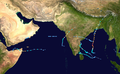
The 2020 North Indian Ocean cyclone season was the costliest North Indian Ocean cyclone season on record, mostly due to the devastating Cyclone Amphan. it was an above average season featuring 5 cyclonic storms. The North Indian Ocean cyclone season has no official bounds, but cyclones tend to form between April and November, with peaks in late April to May and October to November. These dates conventionally delimit the period of each year when most tropical cyclones form in the northern Indian Ocean. The season began on May 16 with the designation of Depression BOB 01 in the Bay of Bengal, which later became Amphan. Cyclone Amphan was the strongest storm in the Bay of Bengal in 21 years and would break Nargis of 2008's record as the costliest storm in the North Indian Ocean. The season concluded with the dissipation of Cyclone Burevi on December 5. Overall, the season was slightly above average, seeing the development of five cyclonic storms.
The scope of the season is limited to the Indian Ocean in the Northern Hemisphere, east of the Horn of Africa and west of the Malay Peninsula. There are two main seas in the North Indian Ocean – the Arabian Sea to the west of the Indian subcontinent, abbreviated ARB by the India Meteorological Department (IMD); and the Bay of Bengal to the east, abbreviated BOB by the IMD.
The official Regional Specialized Meteorological Centre in the basin is the India Meteorological Department (IMD), while the United States's Joint Typhoon Warning Center (JTWC) releases unofficial advisories. On average, three to four cyclonic storms form in this basin every season. [1]
The season began on May 16 with the designation of Depression BOB 01 in the Bay of Bengal, which later became Cyclone Amphan, the strongest storm in the Bay of Bengal recorded since the 1999 Odisha cyclone and breaking the record of Cyclone Nargis of 2008 as the costliest storm ever recorded in the basin. Two more cyclones formed in the Arabian Sea, ARB 01, affecting Yemen and Oman, and Cyclone Nisarga, which made landfall in Maharashtra. After a four-month pause of activity, BOB 02 formed, causing 98 fatalities. Its remnants formed ARB 03. It was a weak storm. After 2 days, BOB 03 formed, impacting and affecting West Bengal, Bangladesh and Northeast India. It was also a weak storm, lasting for 2 days. After its break, Cyclone Gati formed, leaving 8 confirmed, 30 missing as of today, on Somalia and Yemen, where the cyclone took place. On November 23, a depression formed in the Bay of Bengal, and it strengthened into Very Severe Cyclonic Storm Nivar, two days later. It made landfall between Puducherry and Chennai close to Mahabalipuram in the midnight of November 25. It weakened into a well marked low pressure in the early hours of November 27. On November 28, a low pressure formed off the coast of Tamil Nadu, it gradually intensified into a depression, BOB 05. It later intensified into a deep depression and then into a cyclonic storm, named Cyclone Burevi. It made landfall on Sri Lanka as a weak cyclonic storm before it degenerated to an area of low pressure.
Super cyclonic storm (IMD) | |
Category 5 tropical cyclone (SSHWS) | |
Duration | May 16 – May 20 |
---|---|
Peak intensity | 240 km/h (150 mph) (3-min); 920 hPa (mbar) |
At 00:00 UTC on May 16, a depression formed in the southeast Bay of Bengal and was identified as BOB 01. Six hours later, the India Meteorological Department (IMD) upgraded the system to a deep depression. The system began bringing torrential rainfall to Sri Lanka and Southern India. Around 15:00 UTC, the system further developed into Cyclonic Storm Amphan. [2] [3] That morning, landslide and flooding warnings were hoisted for parts of eastern Sri Lanka and the Indian state of Kerala were given expectations of torrential rainfall in the coming days. [4] By 09:00 UTC on May 17, Amphan had intensified into a very severe cyclonic storm. Within 12 hours, the storm had developed an eye and started to rapidly intensify, becoming an extremely severe cyclonic storm. According to the JTWC, it explosively intensified from a Category 1-equivalent cyclone to a Category 4-equivalent cyclone in just 6 hours. The following morning around 10:30 UTC, the IMD upgraded Amphan to a super cyclonic storm with 3-minute sustained winds of 240 km/h (150 mph) and a minimum pressure of 920 hectopascals (27.17 inHg). This marked the second year in a row featuring a super cyclonic storm, the previous year seeing Kyarr in the Arabian Sea. On May 20, at approximately 17:30 IST, the cyclone made landfall near Bakkhali, West Bengal after weakening subsequently. It rapidly weakened once inland, and dissipated on the next day. It left behind a trail of catastrophic damage, and was later confirmed to be the costliest storm ever recorded in the basin.
Depression (IMD) | |
Duration | May 29 – May 31 |
---|---|
Peak intensity | 45 km/h (30 mph) (3-min); 1000 hPa (mbar) |
A depression formed overland near Salalah, Oman on May 29.
The Public Authority for Civil Aviation (PACA) in Oman advised residents to exercise caution and not to venture to low-lying areas or sea. The Supreme Committee asked people to remain at home in non-emergency circumstances. [5] The hospital in Sadah was evacuated as the depression intensified. [6] Over 200 mm (7.9 in) of rain fell in Dhofar Governorate on May 29; [7] some areas received the equivalent of 2 years of rainfall. [8] The highest precipitation total was measured in Mirbat, where 1,055 mm (41.5 in) of rain fell. [9] 2 days of heavy rainfall, accumulating to 260 mm (10 in), caused floods in Salalah. [10] Operations at the port of Salalah were interrupted by the tropical depression. [11] Residents in central Salalah experienced disruptions to power and water services. Military police were dispatched to clear roads and airlift people marooned by the floods. [12] Engineering teams from the Ministry of Defence were deployed to restore utilities and render air where necessary. [13] 2 people were found dead in a wadi due to flash floods, [14] while another person died and three were injured when a building collapsed. [8] More than 50 people were rescued from floods. [15]
Severe cyclonic storm (IMD) | |
Category 2 tropical cyclone (SSHWS) | |
Duration | June 1 – June 4 |
---|---|
Peak intensity | 110 km/h (70 mph) (3-min); 984 hPa (mbar) |
During May 31, an area of low pressure developed over the south-eastern Arabian Sea and remained as a well marked low-pressure area over the same region until the evening. It strengthened into a depression over the east-central and south-east Arabian Sea in the early morning of June 1 when it was centered about 340 km south-west of Goa, 630 km south-southwest of Mumbai and 850 km south-southwest of Gujarat. It gave nearly 400 mm of extremely heavy rain at Kavaratti, Lakshadweep. On June 2, around noon, the prevailing deep depression intensified into a cyclonic storm thereby receiving the name Nisarga. The name has been contributed by Bangladesh. Nisarga intensified into a severe cyclonic storm before making landfall near the coastal town of Alibag in Maharashtra at 12:30 (IST) on June 3. At the time, the system was at peak intensity with 3-minute sustained winds of 110 km/h (70 mph) and a central pressure of 984 hPa (29.06 inHg). The cyclone subsequently weakened into a deep depression by June 4. [16] [17]
Deep depression (IMD) | |
Duration | October 11 – October 14 |
---|---|
Peak intensity | 55 km/h (35 mph) (3-min); 999 hPa (mbar) |
After 3 months of inactivity, on October 11, a depression developed over the west-central Bay of Bengal, though the system was originally observed near the Spratly Islands over the South China Sea on October 6. It continued to move westwards, making landfall in the Khánh Hòa province and further weakened into a low pressure cell while crossing the Indochina Peninsula and re-emerged in the Andaman Sea on October 9. It intensified into a well-marked low-pressure area and then into a depression over the Bay of Bengal on October 10. It further intensified into a deep depression on October 12, remaining practically stationary over the same region. [18] [19] After that, BOB 02 moved west-northwestwards and made landfall in Andhra Pradesh near Kakinada in the early hours of October 13 and weakened again into a depression. [20] The system weakened into a well-marked low-pressure area in south-central Maharashtra on the evening of October 14. [21] Though the system's lower-level circulation was partially exposed due to high vertical wind shear and continuous land interaction, the JTWC re-issued a tropical cyclone advisory on October 15. The IMD also forecasted BOB 02 to reintensify in the Arabian Sea. [22] [23] The low-pressure area intensified into Depression ARB 03 on the early hours of October 17. [24]
Due to BOB 02, Yanam (Puducherry), Andhra Pradesh, Telangana, Kerala, Maharashtra, and coastal Karnataka experienced heavy rain on October 12 and 13, with Hyderabad experiencing 32 cm of record-breaking torrential rain, creating flash floods in the city by October 13. At least 50 people died in different parts of Telangana (of which at least 19 were in the capital city of Hyderabad), 10 in Andhra Pradesh, and 38 in Maharashtra. [25] Extreme crop loss in north Karnataka, Andhra Pradesh and Telangana occurred due to the system. The Telangana CM estimated damage costs to be ₹1,305 crore (US$682 million). [26]
The system delayed the withdrawal of the southwest monsoon season by almost a week, a delay compounded by the formation of Depression ARB 03 and Depression BOB 03. [27]
Depression (IMD) | |
Duration | October 17 – October 19 |
---|---|
Peak intensity | 45 km/h (30 mph) (3-min); 1000 hPa (mbar) |
On October 17, the remnants of Deep Depression BOB 02 intensified into a depression in the East Central Arabian Sea. Moving westwards, the system dissipated into a well marked low pressure on the morning of October 19 over the West Central Arabian Sea due to unfavorable atmospheric conditions.
Fishermen were advised not to go out to sea due to very rough sea conditions. Heavy rainfall occurred off the coast of Mumbai and its surroundings due to the system. No warnings were issued by IMD as no landfall occurred in the Arabian Peninsula. [28]
Monsoon withdrawal was delayed in Maharashtra by a week due to ARB 03. [29]
Depression (IMD) | |
Duration | October 22 – October 24 |
---|---|
Peak intensity | 45 km/h (30 mph) (3-min); 1000 hPa (mbar) |
On October 20, a low pressure formed over Central Bay of Bengal. The system then became more well-marked on October 21 over West Central Bay of Bengal. It further intensified into depression over northwest Bay of Bengal and adjoining Odisha Coast. The system crossed West Bengal's North 24 Parganas and South 24 Parganas and moved over the adjoining Bangladeshi coast on the noon of October 23 with the maximum wind speed of 45 km/h (30 mph). The system weakened into a well marked low-pressure area, 50 km north-northwest of Dhaka on the morning of October 24. [30] [31]
Very severe cyclonic storm (IMD) | |
Category 3 tropical cyclone (SSHWS) | |
Duration | November 21 – November 24 |
---|---|
Peak intensity | 140 km/h (85 mph) (3-min); 976 hPa (mbar) |
On November 17, the India Meteorological Department (IMD) noted the potential for tropical cyclogenesis over the central Arabian Sea in association with an area of low pressure near the Maldives. [32] Convective activity was enhanced by the Madden–Julian oscillation while sea surface temperatures of 29 to 30 °C (84 to 86 °F) and low wind shear favored additional development. [33] [34] By November 18, a weak low-level circulation developed about 1,185 km (736 mi) east-southeast of Socotra. [34] Organization thereafter was stymied as it became embedded within a monsoon trough. Two additional circulations developed to the east and west of the original low; however, the original low steadily became the dominant system by absorbing the previous two circulations. [35] On November 21, two scatterometer passes revealed a single, well-defined low with gale-force winds underneath an area of flaring convection. [36] At 18:00 UTC, the IMD classified the system as Depression ARB 04 about 410 km (250 mi) east-southeast of Socotra. [37] Similarly, the Joint Typhoon Warning Center (JTWC) initiated advisories on the system as Tropical Cyclone 03A. Steered west by a subtropical ridge to the north, little intensification was expected before the cyclone's forecast landfall in Somalia. [36]
During the overnight of 21 to November 22 the small cyclone quickly organized, [38] with a well-defined eye developing. [39] The IMD upgraded the system to a Deep Depression early on November 21 and a Cyclonic Storm soon after. Upon becoming a cyclonic storm, it was assigned the name Gati. [40] [41] The name Gati was contribute by India which means motion in Hindi language. Classified as a "midget system" by the JTWC with a core diameter of only 120 km (75 mi) and a 27 km (17 mi) wide eye, Gati explosively intensified that morning. [42] Within a 12-hour period, the JTWC estimated one-minute sustained winds to have increased from 65 km/h (40 mph) to a peak of 185 km/h (115 mph). This was the fastest intensification during such a short period ever observed in the North Indian Ocean basin. The system's small size enabled it to take advantage of low wind shear and high sea surface temperatures. [43] The IMD assessed Gati to have reached its peak intensity as a Very Severe Cyclonic Storm around 12:00 UTC, with three-minute sustained winds of 140 km/h (85 mph) and a minimum pressure of 976 mbar (28.82 inHg). [44] Six hours later, Gati had made landfall near Hafun in northeastern Somalia with estimated one-minute sustained winds of 165 km/h (105 mph). [43] This made Gati the first hurricane-force cyclone to strike the country since reliable records began and by default the nation's strongest. [43]
Once onshore, land friction-based shear caused convection to quickly become displaced from the storm's center. [45] The low-level circulation became completely exposed early on November 23 as it traversed northeastern Somalia; the system's upper-level circulation and associated convection detached and accelerated west ahead of the surface low. [46] The increasingly elongated circulation of Gati emerged over the Gulf of Aden by 12:00 UTC, [47] and the JTWC issued their final advisory on the system shortly thereafter. [48]
Very severe cyclonic storm (IMD) | |
Category 1 tropical cyclone (SSHWS) | |
Duration | November 23 – November 27 |
---|---|
Peak intensity | 120 km/h (75 mph) (3-min); 982 hPa (mbar) |
On November 22, an area of low pressure was formed in the Bay of Bengal, off the coast of Tamil Nadu. On the same day, the JTWC issued a Tropical Cyclone Formation Alert on the disturbance. It intensified into a depression on the early hours of November 23, as the JTWC also cited that the disturbance intensified into a tropical storm, designating it as Tropical Cyclone 04B. [49] Early on November 24, it intensified into a cyclonic storm and it was named Nivar. It gradually intensified into a Very Severe Cyclonic Storm, reaching its peak intensity. Due to the wind shear, it weakened to a Severe cyclonic storm, shortly before making landfall between Karaikal and Mamallapuram around Puducherry(also known as Pondicherry), Wednesday evening. It reemerged on the Bay of Bengal as a strong deep depression before making its last landfall at Andhra Pradesh before weakening to a well marked low pressure on the morning of November 27. The name Nivar was contributed by Iran which means light.
The IMD issued cyclone warnings early on November 24 on Tamil Nadu, Pondicherry and the country of Sri Lanka as the cyclonic storm accelerates and intensifies.
Cyclonic storm (IMD) | |
Tropical storm (SSHWS) | |
Duration | November 30 – December 5 |
---|---|
Peak intensity | 85 km/h (50 mph) (3-min); 996 hPa (mbar) |
On November 28, a low-pressure area formed off the coast of Aceh. It gradually intensified into a depression on November 30. [50] The JTWC then issued a Tropical Cyclone Formation Alert on the system, that same day. [51] At 03:00 UTC on December 1, the depression was upgraded into a deep depression. [52] At 15:00 UTC, both the IMD and JTWC upgraded it to a cyclonic storm and tropical storm respectively and it was named Burevi, the fifth named storm of the season. [53] [54] The name was initially suggested by the Maldives. [55] At this time, microwave imagery showed well-defined convective banding wrapping tightly around the low-level circulation (LLCC). [56] At 15:00 UTC on December 2, Burevi reached its peak intensity with 1-minute sustained winds of around 85 km/h (55 mph) and a barometric pressure of 996 mbar (29.4 inHg). [57] Shortly afterwards, Burevi made landfall along the east coast of Sri Lanka according to the Sri Lanka's Department of Meteorology. [58]
After weakening over Sri Lanka, Burevi exited into the Gulf of Mannar, early on December 3. [59] However, Burevi slowed down quickly as it became stuck in a col between two subtropical ridges on December 4; thus it stalled just west of Sri Lanka while it weakened back down to the equivalent of a tropical depression due to increasing vertical wind shear. [60] At 06:00 UTC on December 5, Burevi degenerated into an area of low pressure according to the IMD. [61]
Within this basin, a tropical cyclone is assigned a name when it is judged to have reached cyclonic storm intensity with winds of 65 km/h (40 mph). The names were selected by members of the ESCAP/WMO panel on Tropical Cyclones between 2000 and May 2004, before the Regional Specialized Meteorological Center in New Delhi started to assign names in September 2004. There is no retirement of tropical cyclone names in this basin as the list of names is only scheduled to be used once before a new list of names is drawn up. Should a named tropical cyclone move into the basin from the Western Pacific, then it will retain its original name. The next eight names from the list of North Indian Ocean storm names are listed below. Amphan is the last name from the original naming list published in 2004, while Nisarga is the first name from the new naming list published in 2020.
This is a table of all storms in the 2020 North Indian Ocean cyclone season. It mentions all of the season's storms and their names, duration, peak intensities (according to the IMD storm scale), damage, and death totals. Damage and death totals include the damage and deaths caused when that storm was a precursor wave or extratropical low, and all of the damage figures are in 2020 USD.
Name | Dates | Peak intensity | Areas affected | Damage (USD) | Deaths | Refs | ||
---|---|---|---|---|---|---|---|---|
Category | Wind speed | Pressure | ||||||
Amphan | May 16 –21 | Super cyclonic storm | 240 km/h (150 mph) | 920 hPa (27.17 inHg) | West Bengal, Odisha, Bangladesh, Sri Lanka, Bhutan | $14 billion | 128 | [62] |
ARB 01 | May 29 –31 | Depression | 45 km/h (30 mph) | 1000 hPa (29.53 inHg) | Oman, Yemen | Unknown | 3 | [8] |
Nisarga | June 1 –4 | Severe cyclonic storm | 110 km/h (70 mph) | 984 hPa (29.06 inHg) | Maharashtra, Goa | $803 million | 6 | [63] |
BOB 02 | October 11 –14 | Deep depression | 55 km/h (35 mph) | 999 hPa (29.50 inHg) | Andhra Pradesh, Puducherry, Telangana, Kerala, Karnataka, Goa, Maharashtra | $681 million | 98 | [64] [25] |
ARB 03 | October 17 –19 | Depression | 45 km/h (30 mph) | 1000 hPa (29.53 inHg) | Maharashtra | None | None | |
BOB 03 | October 22 –24 | Depression | 45 km/h (30 mph) | 1000 hPa (29.53 inHg) | West Bengal, Bangladesh, Northeast India | None | None | |
Gati | November 21 –24 | Very severe cyclonic storm | 140 km/h (85 mph) | 976 hPa (28.82 inHg) | Somalia, Yemen, Djibouti | Unknown | 9 | [65] [66] |
Nivar | November 23 –27 | Very severe cyclonic storm | 120 km/h (75 mph) | 982 hPa (29.00 inHg) | Sri Lanka, Andhra Pradesh, Tamil Nadu, Puducherry | $600 million | 14 | |
Burevi | November 30 –December 5 | Cyclonic storm | 85 km/h (55 mph) | 996 hPa (29.41 inHg) | Sri Lanka, Tamil Nadu, Kerala | Unknown | 11 | |
Season aggregates | ||||||||
9 systems | May 16 – December 5 | 240 km/h (150 mph) | 920 hPa (27.17 inHg) | $16.1 billion | 269 |
The 2007 North Indian Ocean cyclone season was one of the most active North Indian Ocean cyclone seasons on record. The North Indian Ocean cyclone season has no official bounds, but cyclones tend to form between April and December, with peaks in May and November. These dates conventionally delimit the period of each year when most tropical cyclones form in the northern Indian Ocean.
Below is a timeline of the 2007 North Indian Ocean cyclone season, documenting major events with regards to tropical cyclone formation, strengthening, weakening, landfall, extratropical transition, as well as dissipation. The 2007 North Indian Ocean cyclone season was an ongoing event in the annual cycle of tropical cyclone formation.
The 2002 North Indian Ocean cyclone season was a below average season in terms of tropical cyclone formation. The season had no official bounds, but most storms formed in either May or after October. No depressions or storms formed during the monsoon season from July to September, the first such instance on record. There are two main seas in the North Indian Ocean – the Bay of Bengal to the east of the Indian subcontinent – and the Arabian Sea to the west of India. The official Regional Specialized Meteorological Centre in this basin is the India Meteorological Department (IMD), while the Joint Typhoon Warning Center (JTWC) releases unofficial advisories. An average of four to six storms form in the North Indian Ocean every season with peaks in May and November. Cyclones occurring between the meridians 45°E and 100°E are included in the season by the IMD.
The 1998 North Indian Ocean cyclone season was an active season in annual cycle of tropical cyclone formation. The season has no official bounds but cyclones tend to form between April and December. These dates conventionally delimit the period of each year when most tropical cyclones form in the northern Indian Ocean. There are two main seas in the North Indian Ocean—the Bay of Bengal to the east of the Indian subcontinent and the Arabian Sea to the west of India. The official Regional Specialized Meteorological Centre in this basin is the India Meteorological Department (IMD), while the Joint Typhoon Warning Center releases unofficial advisories. An average of four to six storms form in the North Indian Ocean every season with peaks in May and November. Cyclones occurring between the meridians 45°E and 100°E are included in the season by the IMD.
The 1999 North Indian Ocean cyclone season was an extremely active and deadly tropical cyclone season in recent times. It was an event in the annual cycle of tropical cyclone formation. The North Indian Ocean cyclone season has no official bounds, but cyclones tend to form between April and December, with peaks in May and October-November. These dates conventionally delimit the period of each year when most tropical cyclones form in the northern Indian Ocean.
The 2008 North Indian Ocean cyclone season officially ran throughout the year during 2008, with the first depression forming on April 27. The timeline includes information that was not operationally released, meaning that information from post-storm reviews by the Joint Typhoon Warning Center (JTWC), and the India Meteorological Department (IMD), such as information on a storm that was not operationally warned on. This timeline documents all the storm formations, strengthening, weakening, landfalls, extratropical transitions, as well as dissipation's during the 2008 North Indian Ocean cyclone season.
The 2009 North Indian Ocean cyclone season was an average season in terms of the number of cyclonic storms, however the storms were mostly weak in nature. It was the first season since 2005 wherein a storm did not strength above severe cyclonic storm status. The North Indian Ocean cyclone season has no official bounds, but cyclones tend to form between April and December, with peaks in May and November. These dates conventionally delimit the period of each year when most tropical cyclones form in the northern Indian Ocean.
The 2010 North Indian Ocean cyclone season was one of the most active tropical cyclone season in the North Indian Ocean since 1998. The season saw 8 depressions and 5 named storms forming in the region.
The 2011 North Indian Ocean cyclone season was the least active tropical cyclone season in the North Indian Ocean since 1993. Only two cyclonic storms formed, below the average of four to six. The North Indian Ocean cyclone season has no official bounds, but cyclones tend to form between April and December, with peaks in May and November. These dates conventionally delimit the period of each year when most tropical cyclones form in the northern Indian Ocean. The scope of this article is limited to the Indian Ocean in the Northern Hemisphere, east of the Horn of Africa and west of the Malay Peninsula. There are two main seas in the North Indian Ocean — the Arabian Sea to the west of the Indian subcontinent, abbreviated ARB by the India Meteorological Department (IMD); and the Bay of Bengal to the east, abbreviated BOB by the IMD.
The 2012 North Indian Ocean cyclone season was a very inactive season. The season had a very late start, with the first system forming in October. During the season, only five systems formed, of which only two became cyclonic storms. Both the storms made landfall, and they, along with the deep depressions, were responsible for 128 deaths and economic losses worth at least $56.7 million.
Cyclonic Storm Keila was the first named storm of the 2011 North Indian Ocean cyclone season. A weak system for much of its duration, Keila developed in the western Arabian Sea in late October 2011, amid an area of marginally favorable conditions. On November 2, it briefly organized enough to be classified as a cyclonic storm, which has maximum sustained winds of at least 65 km/h (40 mph). Given the name Keila by the India Meteorological Department (IMD), the storm quickly moved ashore southern Oman near Salalah, and weakened while meandering over the country. The remnants soon after moved offshore, dissipating on November 4.
The 2013 North Indian Ocean cyclone season was an above average and deadly season. The season had no official bounds, but cyclones typically formed between May and December, with the peak from October to November. These dates conventionally delimit the period of each year when most tropical cyclones form in the northern Indian Ocean.
The 2015 North Indian Ocean cyclone season was an event in the annual cycle of tropical cyclone formation. It was an average season with 4 cyclonic storms. The North Indian Ocean cyclone season has no official bounds, but cyclones tend to form between months of April and December, with the peak from May to November. These dates conventionally delimit the period of each year when most tropical cyclones form in the northern Indian Ocean.
The 2016 North Indian Ocean cyclone season was an event in the annual cycle of tropical cyclone formation. It was the deadliest season since 2010, killing more than 400 people. The season was an average one, seeing four named storms, with one further intensifying into a very severe cyclonic storm. The first named storm, Roanu, developed on 19 May while the season's last named storm, Vardah, dissipated on 18 December. The North Indian Ocean cyclone season has no official bounds, but cyclones tend to form between April and December, with the two peaks in May and November. These dates conventionally delimit the period of each year when most tropical cyclones form in the northern Indian Ocean.
The 2015 North Indian Ocean cyclone season was a below-average tropical cyclone season which featured the highest number of deaths since the 2010 season. Despite inactivity in the Bay of Bengal caused by the ongoing El Niño, the season produced an above-average number of tropical cyclones in the Arabian Sea. The first storm of the season, Ashobaa, formed on 7 June, while the final storm of the season, Megh, ultimately dissipated on 10 November.
The 2021 North Indian Ocean cyclone season was an average season, the North Indian Ocean cyclone season has no official bounds, but cyclones tend to form between April and December, peaking between May and November. These dates conventionally delimit the period of each year when most tropical cyclones form in the northern Indian Ocean. The season began on April 2, when a depression designated as BOB 01 was formed in the north Andaman Sea and quickly made landfall in Myanmar. The basin remained quiet for over a month before Cyclone Tauktae formed. It rapidly intensified into an extremely severe cyclonic storm before making landfall in Gujarat, become the strongest storm ever to strike that state since the 1998 Gujarat cyclone. Later that month, BOB 02 formed and later strengthened into Cyclone Yaas. Yaas rapidly intensified into a very severe cyclonic storm before making landfall in northwestern Odisha. The season's strongest tropical cyclone was Cyclone Tauktae, with maximum wind speeds of 185 km/h (115 mph) and a minimum barometric pressure of 950 hPa (28.05 inHg).
The 2022 North Indian Ocean cyclone season was an event in the annual cycle of tropical cyclone formation. It was an above-average season in terms of depressions and average in terms of deep depressions, but slightly below average in terms of cyclonic storms. It was also the least deadly North Indian Ocean cyclone season since 1988, according to official data. The season's strongest tropical cyclone was Cyclone Asani, with maximum wind speeds of 100 km/h and a minimum barometric pressure of 982 hPa. The North Indian Ocean cyclone season has no official bounds, but cyclones tend to form between April and December, with the peak from May to November. These dates conventionally delimit the period of each year when most tropical cyclones form in the northern Indian Ocean.
Very Severe Cyclonic Storm Gati was the strongest tropical cyclone on record to make landfall in Somalia, and one of few tropical cyclones to do so in the country. The seventh depression, third cyclonic storm, and second very severe cyclonic storm of the 2020 North Indian Ocean cyclone season, Gati formed from an area of low pressure in the Arabian Sea, on 21 November. The storm then explosively intensified, becoming a very severe tropical cyclone and reaching its peak intensity, the following day. Gati weakened slightly before making landfall in northeastern Somalia on 22 November. Gati was the first hurricane-force cyclone to make landfall in Somalia on record. Gati then weakened and became disorganized as it moved inland. The JTWC issued its final advisory on Gati shortly after it moved into the Gulf of Aden on 23 November. The name Gati was suggested by India, which means 'motion' in Hindi.
The 2023 North Indian Ocean cyclone season was a highly above-average and deadly season, becoming the most active since 2019, with nine depressions and six cyclonic storms forming. It was the deadliest since 2017, mostly due to Cyclone Mocha, and had the second-highest accumulated cyclone energy (ACE) in the basin, after 2019. It also had the most extremely severe cyclonic storms on record, tying with 1999 and 2019. The North Indian Ocean cyclone season has no official bounds, but cyclones tend to form between April and December, with the peak from May to November. These dates conventionally delimit the period of each year when most tropical cyclones form in the northern Indian Ocean. However, a cyclone can form at any time during the year shown by an unnamed depression that affected Sri Lanka in January–February.
Cyclonic Storm Sitrang was a weak tropical cyclone that affected India and Bangladesh in late October 2022. It was the first cyclone to make landfall in Bangladesh since Cyclone Mora in 2017. Formed on 22 October offshore Andaman and Nicobar Islands, it gradually intensified and peaked as a high-end cyclonic storm before making landfall over Bangladesh close to Barisal by the early hours of 25 October.