2023 North Indian Ocean cyclone season

Last updated

2023 North Indian Ocean cyclone season
2023 North Indian Ocean cyclone season summary.png
Season summary map
Seasonal boundaries
First system formed30 January 2023
Last system dissipated6 December 2023
Strongest storm
Name Mocha
  Maximum winds215 km/h (130 mph)
(3-minute sustained)
  Lowest pressure938 hPa (mbar)
Seasonal statistics
Depressions9, 1 unofficial
Deep depressions7, 1 unofficial
Cyclonic storms6, 1 unofficial
Severe cyclonic storms5
Very severe cyclonic storms4
Extremely severe cyclonic storms3 (record high, tied with 1999 and 2019)
Total fatalities523 total
Total damage$2.47 billion (2023 USD)
Related articles
North Indian Ocean tropical cyclone seasons
2021, 2022, 2023, 2024, 2025

The 2023 North Indian Ocean cyclone season was an above-average and deadly season, becoming the deadliest season since 2017, mainly due to Cyclone Mocha. With nine depressions and six cyclonic storms forming, it became the most active season, featuring the second-highest accumulated cyclone energy (ACE) on record only behind 2019. [1] It also had the most extremely severe cyclonic storms on record, tieing with 1999 and 2019. The North Indian Ocean cyclone season has no official bounds, but cyclones tend to form between April and December, with the peak from May to November. These dates conventionally delimit the period of each year when most tropical cyclones form in the northern Indian Ocean. However, a cyclone can form at any time during the year shown by an unnamed depression that affected Sri Lanka in January-February.

Contents

The scope of this article is limited to the Indian Ocean in the Northern Hemisphere, east of the Horn of Africa and west of the Malay Peninsula. There are two main seas in the North Indian Ocean — the Arabian Sea to the west of the Indian subcontinent, abbreviated ARB by the India Meteorological Department (IMD); and the Bay of Bengal to the east, abbreviated BOB by the IMD.

The official Regional Specialized Meteorological Centre in this basin is the India Meteorological Department (IMD), while the Joint Typhoon Warning Center releases unofficial advisories for interest. On average, three to four cyclonic storms form in this basin every season. [2]

Season summary

Cyclone MichaungCyclone MidhiliCyclone HamoonCyclone TejCyclone BiparjoyCyclone Mocha2023 North Indian Ocean cyclone season
Extremely Severe Cyclonic Storm Mocha and a disturbance below the equator which would later become Fabien on May 13. Mocha and 10 2023-05-13.jpg
Extremely Severe Cyclonic Storm Mocha and a disturbance below the equator which would later become Fabien on May 13.

Nearing the end of January, a tropical depression classified as BOB 01 formed, becoming the first storm in the basin. The storm's formation makes it the first time since 2019 to see a storm develop in the month of January in the basin. BOB 01 was short-lived and dissipated after making landfall on Sri Lanka.

After almost four months of inactivity, the IMD began to monitor a disturbance which was located in the Bay of Bengal on May 6. The system steadily improved and was upgraded into a Depression by the IMD with it being classified as BOB 02. Soon afterwards on May 10, it intensified to a Deep Depression. On the next day, it strengthened into a Cyclonic Storm with the IMD naming the system Mocha. Mocha afterwards, began to rapidly intensify and reached its peak intensity as a Category 5-equivalent cyclone on May 14. Mocha then made landfall just north of Sittwe, Myanmar as a Category 4-equivalent cyclone. The cyclone then rapidly weakened and was last noted over the Chinese province of Yunnan on May 15. Mocha caused heavy damage across Myanmar and Bangladesh and killed at least 400 people. On June 6, a Depression formed in the Arabian Sea, which was later named Biparjoy and rapidly intensified to a Category 1-equivalent cyclone. On June 9, Tropical Storm 03B was designated by the JTWC in the Bay of Bengal. [3] On July 31, a low-pressure area developed into Tropical Storm 04B, which was designated by the JTWC. On September 30, ARB 02 formed.

Systems

Depression BOB 01

Depression (IMD)
BOB 01 2023-01-30 0750Z.jpg   BOB01 2023 track.png
Duration30 January – 2 February
Peak intensity45 km/h (30 mph) (3-min);
1004  hPa  (mbar)

On 25 January, a cyclonic circulation formed over the equatorial Indian Ocean and the adjoining Bay of Bengal. [4] Under the influence of the cyclonic circulation, a low-pressure area formed on 27 January. [5] It would significantly concentrate, becoming a well-marked low-pressure area on 29 January. [6] The system would intensify further, resulting in the IMD recognizing it as a depression the next day. [7] The JTWC would also issue a Tropical Cyclone Formation Alert (TCFA) for the system. [8] However, increasing land interaction with Sri Lanka caused the JTWC to downgrade the system's chance for development to medium and subsequently canceling its TCFA. [9] The disturbance finally weakened into a well-marked low pressure area over the Gulf of Mannar on 2 February. [10]

Extremely Severe Cyclonic Storm Mocha

Extremely severe cyclonic storm (IMD)
Category 5 tropical cyclone (SSHWS)
Mocha 2023-05-14 0050Z.jpg   Mocha 2023 path.png
Duration9 May – 15 May
Peak intensity215 km/h (130 mph) (3-min);
938  hPa  (mbar)

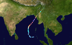
A circulation formed on 6 May over the Bay of Bengal as a result of the amplitude of the Madden–Julian oscillation (MJO), according to the IMD. [11] The JTWC also began monitoring the system on 7 May, marking its flaring convection to the west of the circulation. [12] On 9 May, the system was upgraded to a depression. [13] The JTWC later issued a TCFA on the system as it was situated in very warm sea surface temperatures. [14] The storm subsequently intensified into a deep depression at 03:00 UTC of 9 May, [15] before upgrading further to a cyclonic storm on 11 May, attaining the name Mocha. [16] The JTWC followed suit in upgrading the system to tropical cyclone status the same day. [17] Mocha quickly intensified to a severe cyclonic storm at 12:00 UTC after reaching winds of 105 km/h (65 mph). [18] After forming an eye, [19] Mocha became a very severe cyclonic storm on 12 May. [20] Mocha rapidly intensified to an extremely severe cyclonic storm at 18:00 UTC, [21] before undergoing an eyewall replacement cycle. [22] After having completing the cycle on 13 May, Mocha rapidly intensified and reached a peak intensity as a Category 5-equivalent tropical cyclone the next day, [23] shortly before the storm entered unfavourable conditions. [24] Mocha weakened before making landfall near Sittwe, Myanmar. [25] Mocha began to weaken swiftly after landfall due to Myanmar's terrain, with wind shear degrading the storm further. [26] The system would be downgraded to a depression on 15 May, [27] before becoming marked as a low-pressure area later that day. [28]

The death toll from Cyclone Mocha varies significantly. ASEAN reported a total of 145 deaths, [29] whereas the National Unity Government of Myanmar (NUG) stated that Mocha killed at least 463 people, including three indirect deaths in Bangladesh. The cyclone also injured 719 people and left 101 others missing. [30] It caused about US$1.5 billion of damage in Myanmar. [31]

Extremely Severe Cyclonic Storm Biparjoy

Extremely severe cyclonic storm (IMD)
Category 3 tropical cyclone (SSHWS)
Biparjoy 2023-06-12 0850Z.jpg   Biparjoy 2023 path.png
Duration6 June – 19 June
Peak intensity165 km/h (105 mph) (3-min);
958  hPa  (mbar)

A cyclonic circulation formed over the Arabian Sea on 5 June. [32] On the same day, a low-pressure area formed as a result of cyclonic circulation. [33] The following day, it intensified significantly into a depression. [34] The IMD upgraded the depression to a deep depression, and subsequently to Cyclonic Storm Biparjoy. [35] [36] The JTWC subsequently classified it as Tropical Cyclone 02A. [37] By 00:00 UTC on 7 June, the IMD upgraded the system to a severe cyclonic storm with winds of 100 km/h (65 mph). [38] At the cloud tops Biparjoy warmed and the convective burst collapsed, resulting in an upper-level outflow from the storm and pushing it back towards its system core. [39] Biparjoy was upgraded to a very severe cyclonic storm at 06:00 UTC, at which point the system became a Category 2-equivalent tropical cyclone. [40] [41] The cyclone suffered wind shear due to moderate easterly vertical wind, with the deep convection displaced from the LLCC. [42] Biparjoy unexpectedly rapidly intensified and became a Category 3-equivalent cyclone on 11 June. [43] [44] Biparjoy reached its peak intensity as an extremely severe cyclonic storm, with maximum 3-minute sustained winds of 165 km/h (105 mph). [45] The shear decreased and convective organization and areal extent increased. [46] Biparjoy gradually weaken with convective banding over the northern semicircle. [47] Biparjoy made landfall on 16 June near Naliya, India, with sustained winds of 95 km/h (60 mph). [48] [49] Shortly after its landfall, the JTWC discontinued warnings on the system. [48] and was later marked as a low-pressure area by the IMD on 19 June, prompting the discontinuation of advisories on the system. [50]

In Pakistan, 81,000 people were evacuated from the southeastern coast, and authorities established 75 relief camps at schools to provide assistance. [51] At least 23 people were injured as well as 4,600 villages were affected by power outages in India. [52] A total of 12 people were confirmed to have been killed by the storm. [53] [54] [55]

Deep Depression BOB 03

Deep depression (IMD)
Tropical storm (SSHWS)
95B 2023-07-31 0650Z.jpg   BOB03 2023 track.png
Duration31 July – 3 August
Peak intensity55 km/h (35 mph) (3-min);
988  hPa  (mbar)

On 29 July the IMD noted a cyclonic circulation forming over North Odisha and nearby Gangetic West Bengal. On the same day, it noted the formation of low pressure area over same region and on next day it moved over the Northeastern part of Bay of Bengal. [56] By the same time at 06:00 UTC on 31 July, the JTWC designated it as Invest 95B and gave low chance of developing.[ citation needed ] Despite its low level circulation exposed, it continued to intensify and at 12:00 UTC of the same day, the IMD upgraded it to a well marked low. [56] On 21:00 UTC, the JTWC upgraded it to a tropical storm designated as 04B and peaked as a 40 kt storm.[ citation needed ] On 00:00 UTC of 1 August, the IMD upgraded it to a Depression designated as BOB 03. It continued to intensify till Deep Depression intensity off the coast of Bangladesh and made landfall at Khepupara in Bangladesh at 12:00 UTC. [56] The JTWC stopped issuing advisories by 06:00 UTC stating that it made landfall.[ citation needed ] It continued to move into Eastern India while maintaining intensity. It weakened into Depression over Jharkhand on 2 August 18:00 UTC. Continued to move west-northwest, it became a well-marked low pressure area over north Chhattisgarh and nearby region by 12:00 UTC on 3 August. [56]

Depression ARB 02

Depression (IMD)
ARB 02 2023-09-30 0840Z.jpg   ARB02 2023 path.png
Duration30 September – 1 October
Peak intensity45 km/h (30 mph) (3-min);
1002  hPa  (mbar)

IMD marked a low pressure area off the Konkan coast and rapidly upgraded into a depression designated as ARB 02 on 30 September. [57] ARB 02 made landfall with the same speed and caused heavy rainfall that day. It moved overland and later gradually weakened into a well marked low pressure area by the IMD on 1 October.

Extremely Severe Cyclonic Storm Tej

Extremely severe cyclonic storm (IMD)
Category 3 tropical cyclone (SSHWS)
Tej 2023-10-22 0625Z.jpg   Tej 2023 path.png
Duration20 October – 24 October
Peak intensity175 km/h (110 mph) (3-min);
964  hPa  (mbar)

On 16 October, the India Meteorological Department (IMD) began monitoring a disturbance which had the potential to become a cyclonic circulation in the Arabian Sea. [58] In the Arabian Sea, warmer sea surface temperatures, pointing to positive Indian Ocean Dipole, would help the disturbance develop. [59] A cyclonic circulation formed over the Arabian Sea on 16 October, [58] and a low-pressure area formed as a result of the cyclonic circulation in the morning of 18 October. The system would coalesce into a depression on 21 October. Later that day, the system would intensify into a cyclonic storm, receiving the name Tej. As Tej traversed northwestward, it would be in an environment with warm SSTs, allowing it to rapidly intensify into a Category-3 tropical cyclone on 22 October. The storm would soon weaken, making landfall in the Al Mahrah Governorate of Yemen between 23 and 24 October 2023, bringing significant rainfall and flooding across the eastern half of the country and western parts of Oman. [60]

Torrential rain on Saturday caused flooding on the island of Socotra as the cyclone made landfall. [61] The flooding led to some roads in the governorate's capital city of Hadibu being cut, along with other areas in the archipelago. The Socotra Airport recorded 13 mm (0.51 in) of rain, with wind speeds reaching 25 kn (45 km/h; 30 mph) and gusts exceeding 25 kn (45 km/h; 30 mph). [62]

Very Severe Cyclonic Storm Hamoon

Very severe cyclonic storm (IMD)
Category 2 tropical cyclone (SSHWS)
Hamoon 2023-10-24 0430Z.jpg   Hamoon 2023 path.png
Duration21 October – 25 October
Peak intensity120 km/h (75 mph) (3-min);
985  hPa  (mbar)

On 21 October, Tropical Depression 06B formed in the Bay of Bengal. It was upgraded to a Cyclonic Storm on 23 October, receiving the name Hamoon. On 24 October, Hamoon intensified into a category 2-equivalent cyclone, reaching its peak intensity with sustained winds of 120 km/h (75 mph) and gusts of 140 km/h (85 mph). The storm made landfall over Cox's Bazar in the Bangladesh coast, bringing strong winds and intense rainfall into that area. [63]

As the system lashed the country, five people were killed in total as Hamoon crossed the Cox's Bazar and Chittagong coasts. Hundreds were left homeless as their homes were severely damaged, while trees were uprooted, and electric poles are down. [64]

In India, several districts of Tamil Nadu are expected to experience heavy rainfall for the next two days as cyclonic storm Hamoon is anticipated to further intensify. A yellow warning was issued for six districts in the state. [65]

Cyclonic Storm Midhili

Cyclonic storm (IMD)
Tropical storm (SSHWS)
Midhili 2023-11-17 0100Z.jpg   Midhili 2023 path.png
Duration14 November – 18 November
Peak intensity75 km/h (45 mph) (3-min);
998  hPa  (mbar)

A low-pressure area formed over the Bay of Bengal on 14 November. The system gradually intensified and on 15 November the India Meteorological Department (IMD) designated it as a low pressure. The next day, the low pressure intensified into a deep depression. On 17 November, the IMD named the system "Cyclone Midhili".

In Teknaf Upazila of Cox's Bazar district of Bangladesh, the rain started on the morning of Thursday, November 16, 2023, due to the effect of a deep depression created in the Bay of Bengal. After 8 pm, the intensity of the rain increased. The mud wall of a family living at the foot of the hill in the Panirchhara area of Morichyaghona collapsed. Four members of the family were killed. [66]

Severe Cyclonic Storm Michaung

Severe cyclonic storm (IMD)
Tropical storm (SSHWS)
Michaung 2023-12-04 0835Z.jpg   Michaung 2023 track.png
Duration1 December – 6 December
Peak intensity100 km/h (65 mph) (3-min);
986  hPa  (mbar)

In late November, a low-pressure area crossed into the Bay of Bengal from the Gulf of Thailand. On 1 December, the IMD said that a depression that had formed in the South Andaman Sea. It was expected to move towards the northwest and strengthen in the Bay of Bengal. [67] On December 2, 2023, the system intensified into a deep depression when it was located about 440 km east-southeast of Puducherry. [68] Shortly after that, it intensified into a cyclonic storm, and was assigned the name Michaung. As the storm approached the coast, heavy rain and strong winds battered the affected areas. Chennai, the capital of Tamil Nadu, experienced the worst rains in over 100 years, causing widespread flooding and disrupting daily life. More than 9,000 people were evacuated from low-lying coastal areas as a precautionary measure. According to the IMD, it moved almost directly northwards along the coastline, and on December 5, the storm made landfall between Nellore and Machilipatnam in Andhra Pradesh, bringing heavy rains, fierce winds and storm surges, inundating coastal villages. [69] Cyclone Michaung weakened as it moved inland, gradually losing strength.

The storm's impact was particularly severe in Nellore, Prakasam and Guntur districts, where severe damage to agriculture and infrastructure was reported. [70]

Other system

A tropical cyclone off the coast of Bangladesh in June 9 03B 2023-06-09 0725Z.jpg
A tropical cyclone off the coast of Bangladesh in June 9

Under the influence of another cyclonic circulation, a low-pressure area formed over the northeast Bay of Bengal on 9 June, [71] coalescing into a well-marked low-pressure area later that day. [72] Simultaneously, the JTWC would report that the system became Tropical Cyclone 03B after its low-level circulation center became fully exposed within its disorganized convection. [3] [73] The system would weaken, becoming a low-pressure area over Bangladesh the next day, resulting in the IMD issuing their last advisory. [74] The JTWC would issue its last bulletin on the system on 03:00 UTC on 10 June. [75]

Storm names

Within this basin, a tropical cyclone is assigned a name when it is judged to have reached cyclonic storm intensity with winds of 65 kilometres per hour (40 mph). The names were selected by a new list from the Regional Specialized Meteorological Center in New Delhi by mid year of 2020. [76] There is no retirement of tropical cyclone names in this basin as the list of names is only scheduled to be used once before a new list of names is drawn up. Should a named tropical cyclone move into the basin from the Western Pacific, then it will retain its original name. The next six available names from the List of North Indian Ocean storm names are below. [77]

Season effects

This is a table of all storms in the 2023 North Indian Ocean cyclone season. It mentions all of the season's storms and their names, duration, peak intensities according to the IMD storm scale, damage, and death totals. Damage and death totals include the damage and deaths caused when that storm was a precursor wave or extratropical low. All of the damage figures are in 2023 USD.

NameDatesPeak intensityAreas affectedDamage
(USD)
DeathsRefs
Category Wind speedPressure
BOB 0130 January – 2 FebruaryDepression45 km/h (30 mph)1004 hPa (29.65 inHg) Sri Lanka None0
Mocha 9–15 MayExtremely severe cyclonic storm215 km/h (130 mph)938 hPa (27.70 inHg) Andaman and Nicobar Islands, Sri Lanka, Myanmar, Bangladesh, India, China $1.5 billion463 [78] [25]
Biparjoy 6–19 JuneExtremely severe cyclonic storm165 km/h (105 mph)958 hPa (28.29 inHg) India, Pakistan $124 million17
BOB 0331 July – 3 AugustDeep depression55 km/h (35 mph)988 hPa (29.18 inHg) Myanmar, Bangladesh, West Bengal, Jharkhand, Odisha, Bihar, Chhattisgarh None0
ARB 0230 September – 1 OctoberDepression45 km/h (30 mph)1002 hPa (29.59 inHg) Goa, Maharashtra, Karnataka None0
Tej 20–24 OctoberExtremely severe cyclonic storm175 km/h (110 mph)964 hPa (28.47 inHg) Socotra, Yemen, Oman Unknown2
Hamoon 21–25 OctoberVery severe cyclonic storm120 km/h (75 mph)985 hPa (29.09 inHg) Bangladesh, West Bengal, Mizoram $567 million17
Midhili 14–18 NovemberCyclonic storm75 km/h (45 mph)998 hPa (29.47 inHg) Northeast India, Bangladesh, West Bengal $276 million7
Michaung 1–6 DecemberSevere cyclonic storm100 km/h (65 mph)986 hPa (29.12 inHg) Tamil Nadu, Andhra Pradesh, Odisha, West Bengal, Bangladesh Minimal17
Season aggregates
9 systems30 January – 6 December215 km/h (130 mph)938 hPa (27.70 inHg)$2.47 billion523

See also

    Related Research Articles

    <span class="mw-page-title-main">2007 North Indian Ocean cyclone season</span> North Indian Ocean tropical cyclone season

    The 2007 North Indian Ocean cyclone season was one of the most active North Indian Ocean cyclone seasons on record. The North Indian Ocean cyclone season has no official bounds, but cyclones tend to form between April and December, with peaks in May and November. These dates conventionally delimit the period of each year when most tropical cyclones form in the northern Indian Ocean.

    <span class="mw-page-title-main">Timeline of the 2007 North Indian Ocean cyclone season</span>

    Below is a timeline of the 2007 North Indian Ocean cyclone season, documenting major events with regards to tropical cyclone formation, strengthening, weakening, landfall, extratropical transition, as well as dissipation. The 2007 North Indian Ocean cyclone season was an ongoing event in the annual cycle of tropical cyclone formation.

    <span class="mw-page-title-main">2009 North Indian Ocean cyclone season</span> North Indian Ocean tropical cyclone season

    The 2009 North Indian Ocean cyclone season was an event in the annual cycle of tropical cyclone formation. The North Indian Ocean cyclone season has no official bounds, but cyclones tend to form between April and December, with peaks in May and November. These dates conventionally delimit the period of each year when most tropical cyclones form in the northern Indian Ocean.

    <span class="mw-page-title-main">2010 North Indian Ocean cyclone season</span> North Indian Ocean tropical cyclone season

    The 2010 North Indian Ocean cyclone season was one of the most active tropical cyclone season in the North Indian Ocean since 1998. The season saw 8 depressions and 5 named storms forming in the region.

    <span class="mw-page-title-main">Timeline of the 2009 North Indian Ocean cyclone season</span>

    This is a timeline of the 2009 North Indian Ocean cyclone season, which contains details of when a depression forms, strengthens, weakens, makes landfalls, and dissipates during the 2009 North Indian Ocean cyclone season. It also includes information from post-storm analysis by the Joint Typhoon Warning Center (JTWC), and the India Meteorological Department (IMD) who run the Regional Specialized Meteorological Center in New Delhi, India. RSMC New Delhi's area of responsibility is officially between 45°E and 100E which is east of the Horn of Africa and west of the Malay Peninsula. There are two main seas within the North Indian Ocean, the Arabian Sea and the Bay of Bengal. For storms, these are abbreviated as BOB and ARB by the IMD.

    <span class="mw-page-title-main">Cyclone Phyan</span>

    Cyclonic Storm Phyan developed as a tropical disturbance to the southwest of Colombo in Sri Lanka on November 4, 2009. Over the next couple of days, the disturbance gradually developed before weakening as it made landfall on Southern India on November 7. After the disturbance emerged into the Arabian Sea, it rapidly became more of a concern to the India Meteorological Department (IMD) reporting early on November 9 that the disturbance had intensified into a Depression, and designated it as Depression ARB 03 whilst the Joint Typhoon Warning Center (JTWC) issued a Tropical Cyclone Formation Alert. Later that day, the JTWC designated the system as Cyclone 04A. During the next day, the Depression turned towards the northeast the IMD reported that it had intensified into a Cyclonic Storm and named it as Phyan.

    <span class="mw-page-title-main">2011 North Indian Ocean cyclone season</span> North Indian Ocean tropical cyclone season

    The 2011 North Indian Ocean cyclone season was the least active tropical cyclone season in the North Indian Ocean since 1993. Only two cyclonic storms formed, below the average of four to six. The North Indian Ocean cyclone season has no official bounds, but cyclones tend to form between April and December, with peaks in May and November. These dates conventionally delimit the period of each year when most tropical cyclones form in the northern Indian Ocean. The scope of this article is limited to the Indian Ocean in the Northern Hemisphere, east of the Horn of Africa and west of the Malay Peninsula. There are two main seas in the North Indian Ocean — the Arabian Sea to the west of the Indian subcontinent, abbreviated ARB by the India Meteorological Department (IMD); and the Bay of Bengal to the east, abbreviated BOB by the IMD.

    <span class="mw-page-title-main">2012 North Indian Ocean cyclone season</span> North Indian Ocean tropical cyclone season

    The 2012 North Indian Ocean cyclone season was a very inactive season. The season had a very late start, with the first system forming in October. During the season, only five systems formed, of which only two became cyclonic storms. Both the storms made landfall, and they, along with the deep depressions, were responsible for 128 deaths and economic losses worth at least $56.7 million.

    <span class="mw-page-title-main">Timeline of the 2012 North Indian Ocean cyclone season</span>

    The 2012 North Indian Ocean cyclone season was an event in the annual cycle of tropical cyclone formation. The scope of this article is limited to the Indian Ocean in the Northern Hemisphere, east of the Horn of Africa and west of the Malay Peninsula. There are two main seas in the North Indian Ocean — the Arabian Sea to the west of the Indian subcontinent, abbreviated ARB by the India Meteorological Department (IMD); and the Bay of Bengal to the east, abbreviated BOB by the IMD. The official Regional Specialized Meteorological Centre in this basin is the India Meteorological Department (IMD), while the Joint Typhoon Warning Center releases unofficial advisories. This timeline includes information that was operationally released, meaning that data from post-storm reviews by the IMD, such as a storm that was not operationally warned upon, has not been included. This timeline documents tropical cyclone formations, strengthening, weakening, landfalls, and dissipations during the season.

    <span class="mw-page-title-main">2013 North Indian Ocean cyclone season</span> North Indian Ocean tropical cyclone season

    The 2013 North Indian Ocean cyclone season was an event in the annual cycle of tropical cyclone formation, in which tropical cyclones formed in the North Indian Ocean and Arabian Sea. The season had no official bounds, but cyclones typically formed between May and December, with the peak from October to November. These dates conventionally delimit the period of each year when most tropical cyclones form in the northern Indian Ocean.

    <span class="mw-page-title-main">2014 North Indian Ocean cyclone season</span> North Indian Ocean tropical cyclone season

    The 2014 North Indian Ocean cyclone season was an event in the annual cycle of tropical cyclone formation. The season included two very severe cyclonic storms, both in October, and one other named cyclonic storm, classified according to the tropical cyclone intensity scale of the India Meteorological Department. Cyclone Hudhud is estimated to have caused US$3.58 billion in damage across eastern India, and more than 120 deaths.

    <span class="mw-page-title-main">Cyclone Helen (2013)</span>

    Severe Cyclonic Storm Helen was a relatively weak tropical cyclone that formed in the Bay of Bengal Region on 18 November 2013, from the remnants of Tropical Storm Podul. It was classified as Deep Depression BOB 06 by the IMD on 19 November. As it was moving on a very slow northwest direction on 20 November, it became Cyclonic Storm Helen as it brought light to heavy rainfall in eastern India. It then became a Severe Cyclonic Storm on the afternoon hours of 21 November.

    <span class="mw-page-title-main">2016 North Indian Ocean cyclone season</span> North Indian Ocean tropical cyclone season

    The 2016 North Indian Ocean cyclone season was an event in the annual cycle of tropical cyclone formation. It was the deadliest season since 2010, killing more than 400 people. The season was an average one, seeing four named storms, with one further intensifying into a very severe cyclonic storm. The first named storm, Roanu, developed on 19 May while the season's last named storm, Vardah, dissipated on 18 December. The North Indian Ocean cyclone season has no official bounds, but cyclones tend to form between April and December, with the two peaks in May and November. These dates conventionally delimit the period of each year when most tropical cyclones form in the northern Indian Ocean.

    <span class="mw-page-title-main">2019 North Indian Ocean cyclone season</span> North Indian Ocean tropical cyclone season

    The 2019 North Indian Ocean cyclone season was the second most active North Indian Ocean cyclone season on record in terms of cyclonic storms, the 1992 season was more active according to the Joint Typhoon Warning Center. The season featured 12 depressions, 11 deep depressions, 8 cyclonic storms, 6 severe cyclonic storms, 6 very severe cyclonic storms, 3 extremely severe cyclonic storms, and 1 super cyclonic storm, Kyarr, the first since Cyclone Gonu in 2007. Additionally, it also became the third-costliest season recorded in the North Indian Ocean, only behind the 2020 and 2008 seasons.

    <span class="mw-page-title-main">2021 North Indian Ocean cyclone season</span> North Indian Ocean tropical cyclone season

    The 2021 North Indian Ocean cyclone season was an average season, the North Indian Ocean cyclone season has no official bounds, but cyclones tend to form between April and December, peaking between May and November. These dates conventionally delimit the period of each year when most tropical cyclones form in the northern Indian Ocean. The season began on April 2, when a depression designated as BOB 01 was formed in the north Andaman Sea and quickly made landfall in Myanmar. The basin remained quiet for over a month before Cyclone Tauktae formed. It rapidly intensified into an extremely severe cyclonic storm before making landfall in Gujarat, become the strongest storm ever to strike that state since the 1998 Gujarat cyclone. Later that month, BOB 02 formed and later strengthened into Cyclone Yaas. Yaas rapidly intensified into a very severe cyclonic storm before making landfall in northwestern Odisha. The season's strongest tropical cyclone was Cyclone Tauktae, with maximum wind speeds of 185 km/h (115 mph) and a minimum barometric pressure of 950 hPa (28.05 inHg).

    <span class="mw-page-title-main">2022 North Indian Ocean cyclone season</span> Tropical cyclone season

    The 2022 North Indian Ocean cyclone season was an event in the annual cycle of tropical cyclone formation. It was an above-average season in terms of depressions and average in terms of deep depressions, but slightly below average in terms of cyclonic storms. It was also the least deadly North Indian Ocean cyclone season since 1988, according to official data. The season's strongest tropical cyclone was Cyclone Asani, with maximum wind speeds of 100 km/h and a minimum barometric pressure of 982 hPa. The North Indian Ocean cyclone season has no official bounds, but cyclones tend to form between April and December, with the peak from May to November. These dates conventionally delimit the period of each year when most tropical cyclones form in the northern Indian Ocean.

    <span class="mw-page-title-main">Cyclone Fani</span> North Indian Ocean cyclone in 2019

    Extremely Severe Cyclonic Storm Fani was the worst tropical cyclone to strike the Indian state of Odisha since the 1999 Odisha cyclone. The second named storm and the first severe cyclonic storm of the 2019 North Indian Ocean cyclone season, Fani originated from a tropical depression that formed west of Sumatra in the Indian Ocean on 26 April. Vertical wind shear at first hindered the storm's development, but conditions became more favorable for Fani on 30 April. Fani rapidly strengthened, peaking at Category 5-equivalent intensity with winds of 280 km/h, tying with Cyclone Mocha as the strongest storm on record in the north Indian Ocean, in terms of 1-minute sustained winds. Fani slightly weakened before making landfall, and its convective structure rapidly degraded thereafter, degenerating into a remnant low on 4 May, and dissipating on the next day. It was succeeded by Cyclone Amphan in 2020 which caused a greater overall damage.

    <span class="mw-page-title-main">Cyclone Asani</span> North Indian Ocean cyclone in 2022

    Severe Cyclonic Storm Asani was a strong tropical cyclone that made landfall in India in May 2022. It was the strongest storm of 2022 North Indian Ocean cyclone season. The third depression and deep depression, and the first named storm of the 2022 North Indian Ocean cyclone season, Asani originated from a depression that the Indian Meteorological Department first monitored on May 7. Conditions rapidly favored development as the system became a deep depression by that day before intensifying to a Cyclonic Storm Asani. On the next day it further intensified and peak to a severe cyclonic storm, before making landfall as a deep depression system over Andhra Pradesh. It degenerated into a well marked low-pressure on May 12.

    <span class="mw-page-title-main">Cyclone Mocha</span> North Indian Ocean cyclone in 2023

    Extremely Severe Cyclonic Storm Mocha was a powerful and deadly tropical cyclone in the North Indian Ocean which affected Myanmar and parts of Bangladesh in May 2023. The second depression and the first cyclonic storm of the 2023 North Indian Ocean cyclone season, Mocha originated from a low-pressure area that was first noted by the India Meteorological Department (IMD) on 8 May. After consolidating into a depression, the storm tracked slowly north-northwestward over the Bay of Bengal, and reached extremely severe cyclonic storm intensity. After undergoing an eyewall replacement cycle, Mocha rapidly strengthened, peaking at Category 5-equivalent intensity on 14 May with winds of 280 km/h (175 mph), tying with Cyclone Fani as the strongest storm on record in the North Indian Ocean in terms of 1-minute sustained winds. Mocha slightly weakened before making landfall, and its conditions quickly became unfavorable. Mocha rapidly weakened once inland and dissipated shortly thereafter.

    <span class="mw-page-title-main">Cyclone Biparjoy</span> North Indian Ocean Cyclone in 2023

    Extremely Severe Cyclonic Storm Biparjoy was a powerful, and erratic tropical cyclone that formed over the east-central Arabian Sea. The third depression and the second cyclonic storm of the 2023 North Indian Ocean cyclone season, Biparjoy originated from a depression that was first noted by the India Meteorological Department (IMD) on 6 June, before intensifying into a cyclonic storm. The cyclone steadily weakened due to deep flaring convection. Biparjoy accelerated northeastward, strengthening to a Category 3-equivalent tropical cyclone and an extremely severe cyclonic storm. The cyclone made landfall in Naliya, India on June 16. Biparjoy was downgraded to a depression, and further into a well-marked low-pressure area late on June 19.

    References

    1. "Climatology of Tropical Cyclones over North Indian Ocean (NIO)" (PDF). severeweather.wmo.int. 8 December 2022. Archived (PDF) from the original on 6 March 2023. Retrieved 8 December 2022.
    2. "Annual Frequency of Cyclonic Disturbances (Maximum Wind Speed of 17 Knots or More), Cyclones (34 Knots or More) and Severe Cyclones (48 Knots or More) Over the Bay of Bengal (BOB), Arabian Sea (AS) and Land Surface of India" (PDF). India Meteorological Department. Archived (PDF) from the original on 15 December 2017. Retrieved 30 October 2015.
    3. 1 2 Prognostic Reasoning for Tropical Cyclone 03B (Three) Warning No. 1 (Report). United States Joint Typhoon Warning Center. 9 June 2023. Archived from the original on 12 June 2023. Retrieved 12 June 2023.
    4. Tropical Weather Outlook for North Indian Ocean issued at 0600 UTC of 25.01.2023. based on 0300 UTC of 25.01.2023 (PDF) (Report). New Delhi, India: India Meteorological Department. 25 January 2023. Archived (PDF) from the original on 7 February 2023. Retrieved 12 May 2023.
    5. Tropical Weather Outlook for North Indian Ocean issued at 0600 UTC of 27.01.2023. based on 0300 UTC of 27.01.2023 (PDF) (Report). New Delhi, India: India Meteorological Department. 27 January 2023. Archived from the original (PDF) on 12 May 2023. Retrieved 12 May 2023.
    6. Tropical Weather Outlook for North Indian Ocean issued at 0600 UTC of 29.01.2023. based on 0300 UTC of 29.01.2023 (PDF) (Report). New Delhi, India: India Meteorological Department. 29 January 2023. Retrieved 12 May 2023.
    7. Special Tropical Weather Outlook for North Indian Ocean issued at 0730 UTC of 30.01.2023. based on 0300 UTC of 30.01.2023 (PDF) (Report). New Delhi, India: India Meteorological Department. 29 January 2023. Archived from the original (PDF) on 12 May 2023. Retrieved 12 May 2023.
    8. Tropical Cyclone Formation Alert (Invest 90B) (Report). United States Joint Typhoon Warning Center. 31 January 2023. Archived from the original on 31 January 2023. Retrieved 31 January 2023.
    9. Tropical Cyclone Formation Alert (Invest 90B) (Report). United States Joint Typhoon Warning Center. 1 February 2023. Archived from the original on 31 January 2023. Retrieved 1 February 2023. Alt URL
    10. Special Tropical Weather Outlook for North Indian Ocean issued at 1930 UTC of 02.02.2023. based on 1800 UTC of 02.02.2023 (PDF) (Report). New Delhi, India: India Meteorological Department. 2 February 2023. Archived from the original (PDF) on 12 May 2023. Retrieved 12 May 2023.
    11. Tropical Weather Outlook for North Indian Ocean issued at 0700 UTC of 06.05.2023 based on 0300 UTC of 06.05.2023 (Report). New Delhi, India: India Meteorological Department. 6 May 2023. Archived from the original on 9 May 2023. Retrieved 9 May 2023.
    12. Significant Tropical Weather Advisory for the Indian Ocean, 18Z 7 May 2023 (Report). United States Joint Typhoon Warning Center. 7 May 2023. Retrieved 9 May 2023.
    13. Tropical Weather Outlook for North Indian Ocean issued at 1600 UTC of 09.05.2023. based on 1200 UTC of 09.05.2023 (Report). New Delhi, India: India Meteorological Department. 9 May 2023. Archived from the original on 10 May 2023. Retrieved 9 May 2023.
    14. Tropical Cyclone Formation Alert (Invest 91B) (Report). United States Joint Typhoon Warning Center. 9 May 2023. Archived from the original on 9 May 2023. Retrieved 9 May 2023. Alt URL
    15. Special Tropical Weather Outlook for North Indian Ocean issued at 2030 UTC of 10.05.2023. based on 1800 UTC of 10.05.2023 (PDF) (Report). New Delhi, India: India Meteorological Department. 9 May 2023. Archived (PDF) from the original on 11 May 2023. Retrieved 9 May 2023.
    16. Quadrant Wind Distribution in Association with Mocha over Bay of Bengal on 0000 UTC of 11-05-2023 (Report). New Delhi: India Meteorological Department. 11 May 2023. Archived from the original on 11 May 2023. Retrieved 11 May 2023.
    17. Prognostic Reasoning for Tropical Cyclone 01B (One) Warning No. 1 (Report). United States Joint Typhoon Warning Center. 11 May 2023. Archived from the original on 11 May 2023. Retrieved 11 May 2023. Alt URL
    18. Tropical Cyclone Advisory No. 5 for North Indian Ocean issued at 1500 UTC of 11.05.2023. based on 1200 UTC of 11.05.2023 (PDF) (Report). New Delhi, India: India Meteorological Department. 11 May 2023. Archived from the original (PDF) on 11 May 2023. Retrieved 11 May 2023.
    19. Prognostic Reasoning for Tropical Cyclone 01B (Mocha) Warning No. 4 (Report). United States Joint Typhoon Warning Center. 11 May 2023. Archived from the original on 11 May 2023. Retrieved 11 May 2023. Alt URL
    20. High Sea For Met. Area VIII (N) (Report). New Delhi, India: India Meteorological Department. 12 May 2023. Archived from the original on 12 May 2023. Retrieved 12 May 2023.
    21. Tropical Cyclone Advisory No. 15 for North Indian Ocean issued at 2100 UTC of 12.05.2023. based on 1800 UTC of 12.05.2023 (PDF) (Report). New Delhi, India: India Meteorological Department. 12 May 2023. Archived from the original (PDF) on 12 May 2023. Retrieved 12 May 2023.
    22. Prognostic Reasoning for Tropical Cyclone 01B (Mocha) Warning No. 8 (Report). United States Joint Typhoon Warning Center. 12 May 2023. Archived from the original on 12 May 2023. Retrieved 12 May 2023. Alt URL
    23. Prognostic Reasoning for Tropical Cyclone 01B (Mocha) Warning No. 13 (Report). United States Joint Typhoon Warning Center. 14 May 2023. Archived from the original on 14 May 2023. Retrieved 14 May 2023. Alt URL
    24. Prognostic Reasoning for Tropical Cyclone 01B (Mocha) Warning No. 14 (Report). United States Joint Typhoon Warning Center. 14 May 2023. Archived from the original on 14 May 2023. Retrieved 14 May 2023. Alt URL
    25. 1 2 Alam, Julhas (14 May 2023). "Powerful Cyclone Mocha makes landfall in Myanmar, tearing off roofs and killing at least 3". AP News. Retrieved 14 May 2023.
    26. Tropical Cyclone Advisory No. 30 for North Indian Ocean issued at 1630 UTC of 14.05.2023. based on 1500 UTC of 14.05.2023 (PDF) (Report). New Delhi, India: India Meteorological Department. 14 May 2023. Archived from the original (PDF) on 14 May 2023. Retrieved 14 May 2023.
    27. Special Tropical Weather Outlook for North Indian Ocean issued at 0300 UTC of 15.03.2023. based on 0000 UTC of 15.05.2023 (PDF) (Report). New Delhi, India: India Meteorological Department. 15 May 2023. Archived from the original (PDF) on 15 May 2023. Retrieved 15 May 2023.
    28. Special Tropical Weather Outlook for North Indian Ocean issued at 0700 UTC pf 15.05.2023. based on 0300 UTC of 15.05.2023 (PDF) (Report). New Delhi, India: India Meteorological Department. 15 May 2023. Archived from the original (PDF) on 15 May 2023. Retrieved 15 May 2023.
    29. Situation Update No. 5 - Tropical Cyclone Mocha, Myanmar - 20 May 2023 (Report). ASEAN. 26 May 2023. Retrieved 26 May 2023.
    30. Agarwal, Agushi (17 May 2023). "Cyclone Mocha: Myanmar government claims 435 people dead, seeks international aid". CNBC. Archived from the original on 17 May 2023. Retrieved 17 May 2023.
    31. "Many feared dead after cyclone pummels western Myanmar". Reuters. 16 May 2023. Archived from the original on 16 May 2023. Retrieved 16 May 2023.
    32. Tropical Weather Outlook for North Indian Ocean issued at 0600 UTC of 05.06.2023. based on 0300 UTC of 05.06.2023 (PDF) (Report). New Delhi, India: India Meteorological Department. 5 June 2023. Retrieved 11 June 2023.
    33. Tropical Weather Outlook for North Indian Ocean issued at 1500 UTC of 05.06.2023. based on 1200 UTC of 05.06.2023 (PDF) (Report). New Delhi, India: India Meteorological Department. 5 June 2023. Retrieved 11 June 2023.
    34. Special Tropical Weather Outlook for North Indian Ocean issued at 0500 UTC of 06.06.2023. based on 0000 UTC of 06.06.2023 (PDF) (Report). New Delhi, India: India Meteorological Department. 6 June 2023. Retrieved 11 June 2023.
    35. Tropical Cyclone Advisory 1 for North Indian Ocean issued at 1500 UTC of 06.06.2023. based on 1200 UTC of 06.06.2023 (PDF) (Report). New Delhi, India: India Meteorological Department. 6 June 2023. Retrieved 11 June 2023.
    36. Special Tropical Weather Outlook for North Indian Ocean issued at 0930 UTC of 06.06.2023. based on 0600 UTC of 06.06.2023 (PDF) (Report). New Delhi, India: India Meteorological Department. 6 June 2023. Retrieved 11 June 2023.
    37. Prognostic Reasoning for Tropical Cyclone 02A (Two) Warning No. 1 (Report). United States Joint Typhoon Warning Center. 6 June 2023. Archived from the original on 12 June 2023. Retrieved 12 June 2023.
    38. Tropical Cyclone Advisory 5 for North Indian Ocean issued at 0330 UTC of 07.06.2023. based on 0000 UTC of 07.06.2023 (PDF) (Report). New Delhi, India: India Meteorological Department. 7 June 2023. Retrieved 11 June 2023.
    39. Prognostic Reasoning for Tropical Cyclone 02A (Biparjoy) Warning No. 4 (Report). United States Joint Typhoon Warning Center. 7 June 2023. Archived from the original on 12 June 2023. Retrieved 12 June 2023.
    40. Prognostic Reasoning for Tropical Cyclone 02B (Biparjoy) Warning No. 6 (Report). United States Joint Typhoon Warning Center. 7 June 2023. Archived from the original on 12 June 2023. Retrieved 12 June 2023.
    41. Tropical Cyclone Advisory 7 for North Indian Ocean issued at 0930 UTC of 07.06.2023. based on 0600 UTC of 07.06.2023 (PDF) (Report). New Delhi, India: India Meteorological Department. 7 June 2023. Retrieved 12 June 2023.
    42. Prognostic Reasoning for Tropical Cyclone 02A (Biparjoy) Warning No. 8 (Report). United States Joint Typhoon Warning Center. 8 June 2023. Archived from the original on 12 June 2023. Retrieved 12 June 2023.
    43. Prognostic Reasoning for Tropical Cyclone 02A (Biparjoy) Warning No. 18 (Report). United States Joint Typhoon Warning Center. 10 June 2023. Archived from the original on 12 June 2023. Retrieved 12 June 2023.
    44. Prognostic Reasoning for Tropical Cyclone 02B (Biparjoy) Warning No. 20 (Report). United States Joint Typhoon Warning Center. 11 June 2023. Archived from the original on 12 June 2023. Retrieved 12 June 2023.
    45. Tropical Cyclone Advisory 37 for North Indian Ocean issued at 0345 UTC of 11.06.2023. based on 0000 UTC of 11.06.2023 (PDF) (Report). New Delhi, India: India Meteorological Department. 11 June 2023. Retrieved 12 June 2023.
    46. Prognostic Reasoning for Tropical Cyclone 02A (Biparjoy) Warning No. 23 (Report). United States Joint Typhoon Warning Center. 11 June 2023. Archived from the original on 12 June 2023. Retrieved 12 June 2023.
    47. Prognostic Reasoning for Tropical Cyclone 02A (Biparjoy) Warning No. 31 (Report). United States Joint Typhoon Warning Center. 13 June 2023. Archived from the original on 18 June 2023. Retrieved 13 June 2023.
    48. 1 2 Prognostic Reasoning for Tropical Cyclone 02A (Biparjoy) Warning No. 39 (Report). United States Joint Typhoon Warning Center. 15 June 2023. Archived from the original on 18 June 2023. Retrieved 15 June 2023.
    49. Tropical Cyclone Advisory 76 for North Indian Ocean issued at 0350 UTC of 16.06.2023. based on 0000 UTC of 16.06.2023 (PDF) (Report). New Delhi, India: India Meteorological Department. 16 June 2023. Retrieved 16 June 2023.
    50. National Bulletin No. 98 (ARB/01/2023) (PDF) (Report). New Delhi, India: India Meteorological Department. 19 June 2023. Retrieved 19 June 2023.
    51. "Cyclone Biparjoy: More than 150,000 evacuated as India, Pakistan braces for storm". BBC News. 15 June 2023. Archived from the original on 15 June 2023. Retrieved 15 June 2023.
    52. "Cyclone Biparjoy Live Updates: Rain in parts of Delhi under the influence of Cyclone Biparjoy". India Times. 13 June 2023. Retrieved 16 June 2023.
    53. "Cyclone Biparjoy: 2 dead, 23 injured in Gujarat, confirms NDRF". India Today. Retrieved 16 June 2023.
    54. Khanna, Sumit; Jadhav, Rajendra (13 June 2023). "Seven die as cyclone barrels towards western India, Pakistan". Reuters. Retrieved 16 June 2023.
    55. "Woman killed, husband injured as tree falls on bike due to strong winds in Gujarat". India Today. Retrieved 16 June 2023.
    56. 1 2 3 4 Deep Depression over the Northeast Bay of Bengal (1 st – 3 rd August, 2023): A Report (PDF) (Report). New Delhi, India: Regional Specialized Meteorological Centre - Tropical Cyclones, India Meteorological Department. Archived from the original (PDF) on 18 October 2023. Retrieved 18 October 2023.
    57. National Bulletin NO.2 (PDF) (Report). New Delhi, India: India Meteorological Department. 30 September 2023. Retrieved 30 September 2023.
    58. 1 2 Tropical Weather Outlook For North Indian Ocean (The Bay Of Bengal and the Arabian Sea) Valid for Next 168 Hours Issued at 0600 UTC of 17.10.2023 Based on 0300 UTC of 17.10.2023 (PDF) (Report). New Delhi, India: Regional Specialized Meteorological Centre - Tropical Cyclones, India Meteorological Department. 17 October 2023. Retrieved 18 October 2023.
    59. Kallungal, Dhinesh (16 October 2023). "First post-monsoon cyclone of 2023 brewing over Arabian Sea". The Hindu. ISSN   0971-751X . Retrieved 18 October 2023.
    60. "Yemen: Flash Update #1 - Cyclone Tej, 24 October 2023 [EN/AR] - Yemen | ReliefWeb". 25 October 2023. Archived from the original on 27 October 2023. Retrieved 25 October 2023.
    61. "Schools close, fishermen seek shelter as Yemen braces for cyclone". Arab News. 21 October 2023. Archived from the original on 24 October 2023. Retrieved 23 October 2023.
    62. خاص. "سيول جارفة في سقطرى تأثرا بإعصار تيج". المهرية نت. Archived from the original on 22 October 2023. Retrieved 22 October 2023.
    63. "'Cyclone Hamoon' takes shape over Bay of Bengal. 10 things to know". Hindustan Times. 23 October 2023.
    64. "Five killed as Hamoon lashes Ctg". The Daily Star. 26 October 2023. Retrieved 26 October 2023.
    65. Bureau, DTNEXT (24 October 2023). "Cyclone Hamoon: Six districts of TN to receive heavy rain; yellow warning issued". www.dtnext.in. Retrieved 24 October 2023.
    66. প্রতিবেদক, নিজস্ব (17 November 2023). "গভীর নিম্নচাপ এখন ঘূর্ণিঝড় 'মিধিলি', কত দূরে জানাল আবহাওয়া অফিস". Prothomalo (in Bengali).
    67. "Cyclone Michaung: Check Name Origin and Will it Hit Bay of Bengal?". Jagranjosh.com. 29 November 2023. Retrieved 5 December 2023.
    68. "Cyclone Michaung to hit Andhra coast; PM dials Jagan Reddy, assures all help". India Today. Retrieved 5 December 2023.
    69. "Cyclone Michaung: Landfall likely between Andhra's Nellore & Machilipatnam". www.business-standard.com.
    70. "Michaung cyclone: Heavy rains lash several district of Andhra Pradesh, schools declare holiday". The Times of India. 4 December 2023. ISSN   0971-8257 . Retrieved 5 December 2023.
    71. Tropical Cyclone Advisory 22 for North Indian Ocean issued at 0700 UTC of 09.06.2023. based on 0300 UTC of 09.06.2023 (PDF) (Report). New Delhi, India: India Meteorological Department. 9 June 2023. Retrieved 9 June 2023.
    72. Tropical Cyclone Advisory 23 for North Indian Ocean issued at 1000 UTC of 09.06.2023. based on 0600 UTC of 09.06.2023 (PDF) (Report). New Delhi, India: India Meteorological Department. 9 June 2023. Retrieved 9 June 2023.
    73. Tropical Cyclone Advisory 34 for North Indian Ocean issued at 1700 UTC of 10.06.2023. based on 1500 UTC of 10.06.2023 (PDF) (Report). New Delhi, India: India Meteorological Department. 10 June 2023. Retrieved 10 June 2023.
    74. Tropical Cyclone Advisory 33 for North Indian Ocean issued at 1530 UTC of 10.06.2023. based on 1200 UTC of 10.06.2023 (PDF) (Report). New Delhi, India: India Meteorological Department. 10 June 2023. Retrieved 10 June 2023.
    75. Tropical Cyclone 03B (Three) Warning No. 4 (Report). United States Joint Typhoon Warning Center. 10 June 2023. Archived from the original on 12 June 2023. Retrieved 12 June 2023.
    76. "Tropical Cyclone Naming". public.wmo.int. 30 May 2016. Archived from the original on 4 December 2023. Retrieved 8 December 2022.
    77. "Naming of Tropical Cyclones over the North Indian Ocean" (PDF). rsmcnewdelhi.imd.gov.in. New, Delhi: India Meteorological Department. Archived from the original (PDF) on 3 September 2021. Retrieved 25 September 2021.
    78. Extremely Severe Cyclonic Storm “MOCHA” over the BoB (9th-15th May, 2023): A Report (PDF) (Report). India Meteorological Department. 24 May 2023. Retrieved 9 July 2023.