In the Indian Ocean north of the equator, tropical cyclones can form throughout the year on either side of the Indian subcontinent, although most frequently between April and June, and between October and December.

The 2007 North Indian Ocean cyclone season was one of the most active North Indian Ocean cyclone seasons on record. The North Indian Ocean cyclone season has no official bounds, but cyclones tend to form between April and December, with peaks in May and November. These dates conventionally delimit the period of each year when most tropical cyclones form in the northern Indian Ocean.
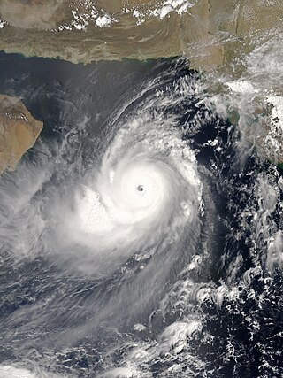
Super Cyclonic Storm Gonu was an extremely powerful tropical cyclone that became the strongest cyclone on record in the Arabian Sea. The second named tropical cyclone of the 2007 North Indian Ocean cyclone season, Gonu developed from a persistent area of convection in the eastern Arabian Sea on June 1, 2007. With a favorable upper-level environment and warm sea surface temperatures, it rapidly intensified to attain peak winds of 240 km/h (150 mph) on June 4, according to the India Meteorological Department. Gonu weakened after encountering dry air and cooler waters, and early on June 6, it made landfall on the easternmost tip of Oman, becoming the strongest tropical cyclone to hit the Arabian Peninsula. It then turned northward into the Gulf of Oman, and dissipated on June 7, after making landfall in southern Iran, the first landfall in the country since 1898.

The 2004 North Indian Ocean cyclone season was the first in which tropical cyclones were officially named in the basin. Cyclone Onil, which struck India and Pakistan, was named in late September. The final storm, Cyclone Agni, was also named, and crossed into the southern hemisphere shortly before dissipation. This storm became notable during its origins and became one of the storms closest to the equator. The season was fairly active, with ten depressions forming from May to November. The India Meteorological Department designated four of these as cyclonic storms, which have maximum sustained winds of at least 65 km/h (40 mph) averaged over three minutes. The Joint Typhoon Warning Center also issued warnings for five of the storms on an unofficial basis.

The 2001 North Indian Ocean cyclone season was fairly quiet, although activity was evenly spread between the Arabian Sea and the Bay of Bengal. There were six depressions tracked by the India Meteorological Department (IMD), which is the official Regional Specialized Meteorological Center for the northern Indian Ocean. The agency also tracked four cyclonic storms, which have maximum winds of at least 65 km/h (40 mph) sustained over 3 minutes. The American-based Joint Typhoon Warning Center (JTWC) tracked an additional storm – Tropical Storm Vamei – which crossed over from the South China Sea at a record-low latitude.

Cyclonic Storm Phyan developed as a tropical disturbance to the southwest of Colombo in Sri Lanka on November 4, 2009. Over the next couple of days, the disturbance gradually developed before weakening as it made landfall on Southern India on November 7. After the disturbance emerged into the Arabian Sea, it rapidly became more of a concern to the India Meteorological Department (IMD) reporting early on November 9 that the disturbance had intensified into a Depression, and designated it as Depression ARB 03 whilst the Joint Typhoon Warning Center (JTWC) issued a Tropical Cyclone Formation Alert. Later that day, the JTWC designated the system as Cyclone 04A. During the next day, the Depression turned towards the northeast the IMD reported that it had intensified into a Cyclonic Storm and named it as Phyan.
The 2001 Gujarat cyclone was the third strongest tropical cyclone, in terms of barometric pressure, to form in the Arabian Sea on record; only Cyclones Gonu in 2007 and Kyarr in 2019 were stronger. The storm originated from a tropical disturbance that formed east of Somalia on May 18. Over the following few days, the system gradually organized into a tropical depression. Tracking eastward, towards the coastline of southwestern India, the storm slowly intensified. Shortly before reaching shore, the system turned north and later west, away from land. After taking this turn, the storm intensified into a very severe cyclonic storm, attaining its peak intensity on May 24 with winds of 215 km/h and a barometric pressure of 932 mbar (hPa). At the time, this ranked the cyclone as the strongest known storm in the Arabian Sea.

India is a country in the north of Indian Ocean that is the most vulnerable to getting hit by tropical cyclones in the basin, from the east or from the west. On average, 2–3 tropical cyclones make landfall in India each year, with about one being a severe tropical cyclone or greater.

The 2014 North Indian Ocean cyclone season was an event in the annual cycle of tropical cyclone formation. The season included two very severe cyclonic storms, both in October, and one other named cyclonic storm, classified according to the tropical cyclone intensity scale of the India Meteorological Department. Cyclone Hudhud is estimated to have caused US$3.58 billion in damage across eastern India, and more than 120 deaths.

Extremely Severe Cyclonic Storm Nilofar was, at the time, the third-strongest cyclone in the Arabian Sea. In late October 2014, it reached peak maximum sustained winds estimated between 205 km/h (125 mph) and 215 km/h (130 mph). The India Meteorological Department (IMD) named it Nilofar; the name refers to the water lily, and was suggested by Pakistan. The western fringes of the storm caused flash flooding in northeastern Oman, killing four people.

The 2015 North Indian Ocean cyclone season was an event in the annual cycle of tropical cyclone formation. It was an average season with 4 cyclonic storms. The North Indian Ocean cyclone season has no official bounds, but cyclones tend to form between months of April and December, with the peak from May to November. These dates conventionally delimit the period of each year when most tropical cyclones form in the northern Indian Ocean.

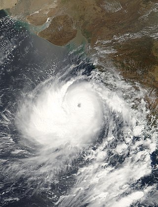
Extremely Severe Cyclonic Storm Chapala was a powerful tropical cyclone that caused moderate damage in Somalia and Yemen during November 2015. Chapala was the third named storm of the 2015 North Indian Ocean cyclone season. It developed as a depression on 28 October off western India, and strengthened a day later into a cyclonic storm. Chapala then rapidly intensified amid favorable conditions. On 30 October, the India Meteorological Department (IMD) estimated that Chapala attained peak three-minute sustained winds of 215 km/h (135 mph). The American-based Joint Typhoon Warning Center (JTWC) estimated sustained winds of 240 km/h (150 mph), making Chapala among the strongest cyclones on record in the Arabian Sea. After peak intensity, Chapala skirted the Yemeni island of Socotra on 1 November, becoming the first hurricane-force storm there since 1922. High winds and heavy rainfall resulted in an island-wide power outage, and severe damage was compounded by Cyclone Megh, which struck Yemen a week later.

The October 1996 India cyclone had an unusual and protracted path that spanned much of the northern Indian Ocean. It originated in a weather disturbance that formed on October 14 in the southern Bay of Bengal, off India's east coast. Moving westward, it struck Andhra Pradesh on October 17 as a well-defined low-pressure area. It crossed southern India and reorganized in the Arabian Sea off the western coast of India. The system developed into a depression on October 22 and quickly intensified while moving northward. By October 24, the cyclone approached hurricane intensity as it developed an eye, reaching peak winds of at least 110 km/h (70 mph). On October 25, the storm abruptly stalled and weakened off Gujarat, and progressed southwestward as a minimal storm. It was no longer classifiable as a tropical cyclone by October 28, although its remnants persisted until November 2 when they dissipated east of Somalia.

The 2016 North Indian Ocean cyclone season was an event in the annual cycle of tropical cyclone formation. It was the deadliest season since 2010, killing more than 400 people. The season was an average one, seeing four named storms, with one further intensifying into a very severe cyclonic storm. The first named storm, Roanu, developed on 19 May while the season's last named storm, Vardah, dissipated on 18 December. The North Indian Ocean cyclone season has no official bounds, but cyclones tend to form between April and December, with the two peaks in May and November. These dates conventionally delimit the period of each year when most tropical cyclones form in the northern Indian Ocean.

The 2018 North Indian Ocean cyclone season was one of the most active North Indian Ocean cyclone seasons since 1992, with the formation of fourteen depressions and seven cyclones. The North Indian Ocean cyclone season has no official bounds, but cyclones tend to form between April and December, with the two peaks in May and November. These dates conventionally delimit the period of each year when most tropical cyclones form in the northern Indian Ocean.

The 2019 North Indian Ocean cyclone season was the second most active North Indian Ocean cyclone season on record in terms of cyclonic storms, the 1992 season was more active according to the Joint Typhoon Warning Center. The season featured 12 depressions, 11 deep depressions, 8 cyclonic storms, 6 severe cyclonic storms, 6 very severe cyclonic storms, 3 extremely severe cyclonic storms, and 1 super cyclonic storm, Kyarr, the first since Cyclone Gonu in 2007. Additionally, it also became the third-costliest season recorded in the North Indian Ocean, only behind the 2020 and 2008 seasons.

The 2020 North Indian Ocean cyclone season was the costliest North Indian Ocean cyclone season on record, mostly due to the devastating Cyclone Amphan. it was an above average season featuring 5 cyclonic storms. The North Indian Ocean cyclone season has no official bounds, but cyclones tend to form between April and November, with peaks in late April to May and October to November. These dates conventionally delimit the period of each year when most tropical cyclones form in the northern Indian Ocean. The season began on May 16 with the designation of Depression BOB 01 in the Bay of Bengal, which later became Amphan. Cyclone Amphan was the strongest storm in the Bay of Bengal in 21 years and would break Nargis of 2008's record as the costliest storm in the North Indian Ocean. The season concluded with the dissipation of Cyclone Burevi on December 5. Overall, the season was slightly above average, seeing the development of five cyclonic storms.
The 2015 North Indian Ocean cyclone season was a below-average tropical cyclone season which featured the highest number of deaths since the 2010 season. Despite inactivity in the Bay of Bengal caused by the ongoing El Niño, the season produced an above-average number of tropical cyclones in the Arabian Sea. The first storm of the season, Ashobaa, formed on 7 June, while the final storm of the season, Megh, ultimately dissipated on 10 November.
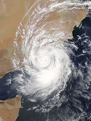
Extremely Severe Cyclonic Storm Mekunu was the strongest storm to strike Oman's Dhofar Governorate since 1959. The second named storm of the 2018 North Indian Ocean cyclone season, Mekunu developed out of a low-pressure area on May 21. It gradually intensified, passing east of Socotra on May 23 as a very intense tropical cyclone. On May 25, Mekunu reached its peak intensity. The India Meteorological Department estimated 10 minute sustained winds of 175 km/h (110 mph), making Mekunu an extremely severe cyclonic storm. The American-based Joint Typhoon Warning Center estimated slightly higher 1 minute winds of 185 km/h (115 mph). While at peak intensity, Mekunu made landfall near Raysut, Oman, on May 25. The storm rapidly weakened over land, dissipating on May 27.