| Timeline of the 2007 North Indian Ocean cyclone season | |||||
|---|---|---|---|---|---|
 Season summary map | |||||
| Season boundaries | |||||
| First system formed | May 1, 2007 | ||||
| Last system dissipated | November 16, 2007 | ||||
| Strongest system | |||||
| Name | Gonu | ||||
| Maximum winds | 240 km/h (150 mph) (3-minute sustained) | ||||
| Lowest pressure | 920 hPa (mbar) | ||||
| Longest lasting system | |||||
| Name | ARB 02 | ||||
| Duration | 7 days | ||||
| |||||
This is a timeline of the 2007 North Indian Ocean cyclone season , documenting major events regarding tropical cyclone formation, strengthening, weakening, landfall, extratropical transition, as well as dissipation.
Contents
- Timeline of storms
- January to April
- May
- June
- July
- August
- September
- October
- November
- December
- See also
- References
- External links
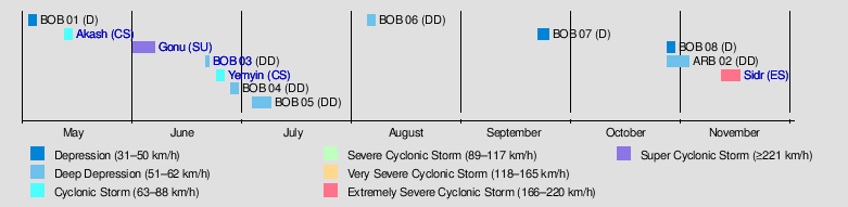
In the timeline all landfalls are bolded. Where the exact time of an event is unclear, c. is used to denote the approximate time.
The India Meteorological Department (IMD) is the official Regional Specialized Meteorological Centre in this basin, while the Joint Typhoon Warning Center releases unofficial advisories.
Storms tracked by the JTWC are referred to numerically to avoid confusion as the JTWC sometimes recognises a storm at a different intensity compared to the IMD.
The graphical bar gives a brief overview of storm activity during the season, and a storm's maximum intensity category in terms of wind speed is included as a colour bar. This is given by the IMD's values of maximum 10-minute sustained winds. The colour scheme is detailed to the right.