2002 North Indian Ocean cyclone season

Last updated

2002 North Indian Ocean cyclone season
2002 North Indian Ocean cyclone season summary.png
Season summary map
Seasonal boundaries
First system formedMay 6, 2002
Last system dissipatedDecember 25, 2002
Strongest storm
Name BOB 03
  Maximum winds100 km/h (65 mph)
(3-minute sustained)
  Lowest pressure984 hPa (mbar)
Seasonal statistics
Depressions7
Deep depressions6
Cyclonic storms4
Severe cyclonic storms1
Total fatalitiesAt least 182 total
Total damage$25 million (2002 USD)
Related articles
North Indian Ocean tropical cyclone seasons
2000, 2001, 2002, 2003, 2004

The 2002 North Indian Ocean cyclone season was a below average season in terms of tropical cyclone formation. The season had no official bounds, but most storms formed in either May or after October. No depressions or storms formed during the monsoon season from July to September, the first such instance on record. There are two main seas in the North Indian Ocean – the Bay of Bengal to the east of the Indian subcontinent – and the Arabian Sea to the west of India. The official Regional Specialized Meteorological Centre in this basin is the India Meteorological Department (IMD), while the Joint Typhoon Warning Center (JTWC) releases unofficial advisories. An average of four to six storms form in the North Indian Ocean every season with peaks in May and November. [1] Cyclones occurring between the meridians 45°E and 100°E are included in the season by the IMD. [2]

Contents

Overall, there was a total of seven depressions and four cyclonic storms. The most intense and deadly tropical cyclone of the season, the West Bengal cyclone, lashed that province of India and Bangladesh in the month of November. Rough seas offshore caused at least 173 drownings offshore Bangladesh and India, while over 100 people were left missing. In West Bengal alone, 124 fatalities were reported, with over one hundred people still missing. Flooding occurred there and some areas of Bangladesh, particularly the capital city of Dhaka. Another notable storm was the Oman cyclone in May. It made a rare landfall in the Omani region of Dhofar. The storm brought historic rainfall to Oman, which in turn brought flooding to the region. Nine people drowned and damage to property, crops, and transportation reached US$25 million (2002 dollars).

Season summary

2002 Bangladesh cyclone2002 Oman cyclone2002 North Indian Ocean cyclone season

Overall, the season was inactive in terms of tropical cyclone formation. The IMD tracked six tropical cyclones, which was below the average of 13 to 14 per season. [3] No storms were active from June to September during the monsoon season, [3] the first such instance of no depressions in the 115 year record of the IMD. [4] Collectively, the storms of this season resulted in at least 182 deaths and $25 million (2002 USD) in damage, all of which can be attributed to ARB 01 and BOB 04. [5] [6] [7]

The first storm of the season, ARB 01, developed on May 6 out of an area of low pressure over the Arabian Sea. It peaked winds of 65 km/h (40 mph) before making landfall near Salalah, Oman on May 10. The storm dissipated shortly thereafter. [3] A deep depression, classified as BOB 02, developed in the Andaman Sea on May 10. The deep depression remained disorganized and made landfall near Yangon, Burma before dissipating on May 12. [8] Later that month, a tropical depression, recognized only by the Thailand Meteorological Department, developed in the Bay of Bengal and also made landfall in Burma. [9] Activity in the North Indian Ocean then went dormant for over five months, a direct result of the monsoon season in the region. [3] Tropical cyclogenesis resumed with the development of Tropical Depression BOB 03 forming near Andhra Pradesh on October 22. [10]

On November 11, a severe cyclonic storm – numbered BOB 04 – developed in the Bay of Bengal. It soon became the strongest tropical cyclone with maximum sustained winds of 100 km/h (60 mph) and a minimum barometric pressure of 984  mbar (29.1  inHg ). BOB 04 made landfall in Bangladesh on November 12, hours before dissipating. Later in November, another cyclonic storm – assigned to BOB 05 – formed in the Bay of Bengal on November 23. It moved northward before eventually curving westward and dissipating on November 28. [11] The final tropical cyclone developed southwest of Sri Lanka on December 21. The system headed generally east-northeastward and strengthened into cyclonic storm on December 24, before demising well east of Sri Lanka on the following day. [12]

Systems

Cyclonic Storm ARB 01

Cyclonic storm (IMD)
Tropical storm (SSHWS)
ARB 01 2002-05-09 0705Z.jpg   Cyclone 01A 2002 track.png
DurationMay 6 – May 10
Peak intensity65 km/h (40 mph) (3-min) 996  hPa  (mbar)

A low-pressure area in the Arabian Sea developed into a depression while located a few hundred miles west-northwest of Maldives at 0300 UTC on May 6. [3] [13] By the following day, it had intensified into a deep depression. However, dry air diminished convection, [3] causing the cyclone to weaken to a depression on May 8 at 0300 UTC. [13] Nine hours later, it was upgraded back to a deep depression. On May 8, the cyclone turned west-northwestward. Further intensification occurred, with the deep depression becoming a cyclonic storm at 0600 UTC on May 9. The storm maintained its intensity until weakening slightly early on May 10, while briefly tracking northwestward. Shortly thereafter, it made landfall near Salalah, Oman. The cyclone rapidly weakened and dissipated inland later on May 10. [3]

Waves up to 4 m (13 ft) lashed the coast of Oman, though no coastal flooding occurred. Wind gusts reaching 106 km/h (66 mph) affected some areas of Oman, while light winds were reported in Al Ghaydah, Yemen. The storm brought heavy rainfall to the Dhofar region of Oman, peaking at 251 mm (9.9 in) in the city of Qairoon. Areas in the vicinity of the landfall location of the storm experienced the highest precipitation totals in 30 years. [8] As a result, wadis quickly became rivers, sweeping away cars and drowning nine people. [5] [8] Additionally, property, crops, and transportation suffered impacts from flooding. [5] Damage from the storm totaled to $25 million, all of which was in Oman. [6]

Deep Depression BOB 01

Deep depression (IMD)
Tropical storm (SSHWS)
BOB 01 2002-05-12 0420Z.jpg   Cyclone 02B 2002 track.png
DurationMay 10 – May 12
Peak intensity55 km/h (35 mph) (3-min) 991  hPa  (mbar)

A tropical disturbance near Sumatra was tracked starting on May 7. Although the system was disorganized and convection was sporadic, it managed to develop a low-level center of circulation on May 9. After significant strengthening on May 10, a Tropical Cyclone Formation Alert (TCFA) was issued later that day. Shortly thereafter, the disturbance became Tropical Cyclone 02B at 1200 UTC, while located about 230 km (140 mi) southeast of Port Blair, Andaman and Nicobar Islands. Deep convection continued to be sporadic until becoming persistent early on May 11. Around that time, the deep depression reached 3-minute sustained winds of 55 km/h (35 mph). [8]

Later on May 11, Cyclone 01B unexpectedly accelerated to the north-northeast while crossing the northern Andaman Sea. [8] At 2300 UTC on May 11, the cyclone made landfall just east of Yangon, Burma. [13] By early on the following day, it weakened to a depression. The final warning on Cyclone 01B was issued at 0600 UTC on May 12 and indicated that the storm dissipated about 175 km (109 mi). The city of Yangon experienced wind gusts of about 47 km/h (29 mph), according to the JTWC. Cyclone 01B co-existed in a pair, with the southern counterpart being Tropical Cyclone Errol, which was in the South Indian Ocean within Australian Bureau of Meteorology's responsibility. [8]

Tropical Depression

Tropical depression (TMD)
Unnumbered 2002-05-17 0440Z.jpg   TMD Depression 2002 track.png
DurationMay 17 – May 19
Peak intensity55 km/h (35 mph) (10-min) 995  hPa  (mbar)

The Thailand Meteorological Department began issuing advisories on a tropical depression in the Bay of Bengal on May 17. Several hours later, the JTWC issued a TCFA for the system. Minimal strengthening occurred as the depression tracked rather swiftly toward the coast of Myanmar. At 0900 UTC on May 18, the depression made landfall near Taungup, Rakhine State, with winds of 55 km/h (34 mph). The JTWC cancelled the TCFA seven hours later, having never classified the system as a tropical depression. It weakened inland and dissipated over eastern Myanmar at 0300 UTC on May 19. Impact from this system is unknown. [9]

Depression BOB 02

Depression (IMD)
BOB 02 2002-10-24 0745Z.jpg   BOB02 2002 track.png
DurationOctober 22 – October 25
Peak intensity45 km/h (30 mph) (3-min) 1003  hPa  (mbar)

The JTWC issued a TCFA late on October 22 for a depression located about 235 km (146 mi) east-southeast of Chennai, Tamil Nadu. By 0300 UTC on the following day, the India Meteorological Department issued a bulletin on the depression. Due to multiple low-level center of circulations and an ill-defined structure, the depression was difficult to track. It moved in a quasi-stationary motion offshore Andhra Pradesh. Minimal intensification occurred, and by 1930 UTC on October 25, the depression dissipated about 235 km (146 mi) north of Chennai. [10]

Severe Cyclonic Storm BOB 03

Severe cyclonic storm (IMD)
Tropical storm (SSHWS)
BOB 03 2002-11-12 0510Z.jpg   Cyclone 03B 2002 track.png
DurationNovember 10 – November 12
Peak intensity100 km/h (65 mph) (3-min) 984  hPa  (mbar)

Tropical Cyclone 03B developed as a depression near Chennai, India on November 10. Later that day, it intensified into a deep depression while tracking northward. As the storm was moving to the northeast, it was upgraded to a cyclonic storm, due to gale-force winds. The cyclone came under the influence of mid-latitude trough, which caused the storm to accelerate to the north-northeast. Early on November 12, it was upgraded to a severe cyclonic storm, [11] as maximum sustained winds reached 100 km/h (62 mph). Later that day at 0900 UTC, the storm made landfall near Sagar Island, West Bengal. [13] The cyclone quickly weakened inland and by 1200 UTC on November 12, the IMD issued its final advisory, while the system situated about 200 km (120 mi) northeast of Kolkata. [11]

Rough seas offshore Orissa caused two fishing trawlers to collide, resulting in 18 fatalities, while two additional trawlers were reported missing. [3] In West Bengal, the storm uprooted trees and dropped heavy rainfall, as well as causing two deaths. Strong winds and heavy rainfall in Bangladesh impacted many cities and villages, including the capital city of Dhaka, forcing thousands to evacuate. [11] Ten wooden trawlers carrying 150 men sank offshore Bangladesh. Eight additional boats carrying 60 occupants were reported missing. [14] Along coastal areas of the country, winds destroyed bamboo huts, uprooted trees, and disrupted road transport between various towns and villages. The storm was attributed to at least 51 deaths, while between 111 and 560 people were classified as missing. [11]

Cyclonic Storm BOB 04

Cyclonic storm (IMD)
Tropical storm (SSHWS)
BOB 04 2002-11-25 0740Z.jpg   Cyclone 04B 2002 track.png
DurationNovember 23 – November 28
Peak intensity85 km/h (50 mph) (1-min) 991  hPa  (mbar)

A low-pressure area developed within an equatorial trough centered over the southeastern Bay of Bengal on November 22. After tracking northwestward for about twenty-four hours, the system developed into Tropical Cyclone 04B, while located about 815 km (506 mi) east-southeast of Chennai, Tamil Nadu. While moving northward, it intensified into a deep depression at 1800 UTC on November 23. Strengthening continued and early on November 24, the deep depression was upgraded to a cyclonic storm. Later that day, the storm turned northwestward and later curved westward. [3]

As it was moving westward, the system became disorganized and the center was difficult to track. Despite significant convection, the JTWC discontinued advisories on the storm at 1200 UTC on November 25, possibly in anticipation that it would soon dissipate. However, it remained a tropical cyclone for almost three more days. [3] [11] By 1200 UTC on November 27, the storm was downgraded to a deep depression. The system moved northwestward and weakened further to a depression six hours later. It degenerated into an area of low-pressure area while located over the central Bay of Bengal on November 28. [13]

Cyclonic Storm BOB 05

Cyclonic storm (IMD)
Tropical storm (SSHWS)
BOB 05 2002-12-23 0510Z.jpg   Cyclone 05B 2002 track.png
DurationDecember 21 – December 25
Peak intensity65 km/h (40 mph) (1-min) 997  hPa  (mbar)

A low-pressure area developed in the Intertropical Convergence Zone near Sri Lanka on December 20. [12] Early on December 21, the system developed into a depression. [13] The JTWC issued a TCFA at 1251 UTC on December 22, while it was centered 340 kilometres (210 mi) south-southeast of Sri Lanka. By 1800 UTC on December 23, the JTWC initiated advisories on Tropical Cyclone 05B, which was located about 160 km (99 mi) southeast of Dondra Head, Sri Lanka. [12] At that time, the storm had intensified into a deep depression. Further strengthening occurred, and it was upgraded to a cyclonic storm early on December 24. [13]

After peaking with maximum sustained winds of 65 km/h (40 mph) and a minimum barometric pressure of 997 mbar (29.4 inHg) on December 24, [12] [13] the storm soon weakened and convection diminished, possibly due to interaction with a nearby tropical disturbance. [12] By early on the following day, it was downgraded to a deep depression while moving toward the northeast. Later that day, Cyclonic Storm BOB 06 weakened to a depression. [3] At 1800 UTC on December 25, the JTWC issued a final advisory on the cyclone, citing that it degenerated into a remnant low-pressure area while located about 685 km (426 mi) east-southeast of Dondra Head, Sri Lanka. [12]

Season effects

This is a table of all storms in the 2002 North Indian Ocean cyclone season. It mentions all of the season's storms and their names, duration, peak intensities (according to the IMD storm scale), damage, and death totals. Damage and death totals include the damage and deaths caused when that storm was a precursor wave or extratropical low, and all of the damage figures are in 2002 USD.

NameDatesPeak intensityAreas affectedDamage
(USD)
DeathsRefs
Category Wind speedPressure
ARB 01 May 6–10Cyclonic storm65 km/h (40 mph)996 hPa (29.41 inHg) Maldives, Oman, Salalah $25 million 9
BOB 01May 10–12Deep depression55 km/h (35 mph)991 hPa (29.26 inHg)None None None
TDMay 17–19Tropical depression55 km/h (34 mph)995 hPa (29.38 inHg)None None None
BOB 02October 22–25Depression45 km/h (30 mph)1,003 hPa (29.62 inHg)None None None
BOB 03 November 10–12Severe cyclonic storm100 km/h (62 mph)984 hPa (29.06 inHg) Bangladesh, India None 173
BOB 04November 23–28Cyclonic storm85 km/h (55 mph)991 hPa (29.26 inHg)None None None
BOB 05December 21–25Cyclonic storm65 km/h (40 mph)997 hPa (29.44 inHg)None None None
Season aggregates
7 systemsMay 6 
December 25 
100 km/h (62 mph)984 hPa (29.06 inHg)$25 million182

See also

Related Research Articles

<span class="mw-page-title-main">2005 North Indian Ocean cyclone season</span> Cyclone season in the North Indian ocean

The 2005 North Indian Ocean cyclone season caused much devastation and many deaths in Southern India despite the storms’ weakness. The basin covers the Indian Ocean north of the equator as well as inland areas, sub-divided by the Arabian Sea and the Bay of Bengal. Although the season began early with two systems in January, the bulk of activity was confined from September to December. The official India Meteorological Department tracked 12 depressions in the basin, and the unofficial Joint Typhoon Warning Center (JTWC) monitored two additional storms. Three systems intensified into a cyclonic storm, which have sustained winds of at least 63 km/h (39 mph), at which point the IMD named them.

<span class="mw-page-title-main">1992 North Indian Ocean cyclone season</span>

The 1992 North Indian Ocean cyclone season was unofficially the most active year on record for the basin, with 10 tropical storms developing, according to the Joint Typhoon Warning Center (JTWC). There are two main seas in the North Indian Ocean – the Bay of Bengal to the east of the Indian subcontinent – and the Arabian Sea to the west of India. The official Regional Specialized Meteorological Centre in this basin is the India Meteorological Department (IMD), while the JTWC releases unofficial advisories. An average of four to six storms form in the North Indian Ocean every season with peaks in May and November. Cyclones occurring between the meridians 45°E and 100°E are included in the season by the IMD.

<span class="mw-page-title-main">2007 North Indian Ocean cyclone season</span> North Indian Ocean tropical cyclone season

The 2007 North Indian Ocean cyclone season was one of the most active North Indian Ocean cyclone seasons on record. The North Indian Ocean cyclone season has no official bounds, but cyclones tend to form between April and December, with peaks in May and November. These dates conventionally delimit the period of each year when most tropical cyclones form in the northern Indian Ocean.

<span class="mw-page-title-main">2003 North Indian Ocean cyclone season</span> North Indian Ocean tropical cyclone season

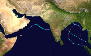
The 2003 North Indian Ocean cyclone season was the last season that tropical cyclones were not publicly labeled by India Meteorological Department (IMD). Also was mostly focused in the Bay of Bengal, where six of the seven depressions developed. The remaining system was a tropical cyclone that developed in the Arabian Sea in November, which was also the only system that did not affect land. There were three cyclonic storms, which was below the average of 4–6. Only one storm formed before the start of the monsoon season in June, although it was also the most notable. On May 10, a depression formed in the central Bay of Bengal, and within a few days became a very severe cyclonic storm. After it stalled, it drew moisture from the southwest to produce severe flooding across Sri Lanka, killing 254 people and becoming the worst floods there since 1947. Damage on the island totaled $135 million (2003 USD). The storm eventually made landfall in Myanmar on May 19. It is possible that the storm contributed to a deadly heat wave in India due to shifting air currents.

<span class="mw-page-title-main">2001 North Indian Ocean cyclone season</span> Cyclone season in the North Indian ocean

The 2001 North Indian Ocean cyclone season was fairly quiet, although activity was evenly spread between the Arabian Sea and the Bay of Bengal. There were six depressions tracked by the India Meteorological Department (IMD), which is the official Regional Specialized Meteorological Center for the northern Indian Ocean. The agency also tracked four cyclonic storms, which have maximum winds of at least 65 km/h (40 mph) sustained over 3 minutes. The American-based Joint Typhoon Warning Center (JTWC) tracked an additional storm – Tropical Storm Vamei – which crossed over from the South China Sea at a record-low latitude.

<span class="mw-page-title-main">2000 North Indian Ocean cyclone season</span> Cyclone season in the North Indian ocean

The 2000 North Indian Ocean cyclone season was fairly quiet compared to its predecessor, with all of the activity originating in the Bay of Bengal. The basin comprises the Indian Ocean north of the equator, with warnings issued by the India Meteorological Department (IMD) in New Delhi. There were six depressions throughout the year, of which five intensified into cyclonic storms – tropical cyclones with winds of 65 mph (105 km/h) sustained over 3 minutes. Two of the storms strengthened into a Very Severe Cyclonic Storm, which has winds of at least 120 km/h (75 mph), equivalent to a minimal hurricane. The Joint Typhoon Warning Center (JTWC) also tracked storms in the basin on an unofficial basis, estimating winds sustained over 1 minute.

<span class="mw-page-title-main">2002 Oman cyclone</span> North Indian cyclone in 2002

The 2002 Oman cyclone was a tropical cyclone that struck the Dhofar region of Oman in May 2002. The first storm of the 2002 North Indian Ocean cyclone season, it developed on May 6 in the Arabian Sea, and it maintained a general west-northwest track for much of its duration. The system reached cyclonic storm status on May 9, meaning it attained winds of greater than 65 km/h (40 mph), and on May 10 it made landfall near Salalah; shortly thereafter it dissipated. The storm was rare, in the sense that it was one of only twelve tropical cyclones on record to approach the Arabian Peninsula in the month of May.

<span class="mw-page-title-main">1995 North Indian Ocean cyclone season</span> Cyclone season 1995 in the North Indian ocean

The 1995 North Indian Ocean cyclone season was below-average and was primarily confined to the autumn months, with the exception of three short-lived deep depressions in May. There were eight depressions in the basin, which is Indian Ocean north of the equator. The basin is subdivided between the Bay of Bengal and the Arabian Sea on the east and west coasts of India, respectively. Storms were tracked by the India Meteorological Department (IMD), which is the basin's Regional Specialized Meteorological Center, as well as the American-based Joint Typhoon Warning Center (JTWC) on an unofficial basis.

<span class="mw-page-title-main">1996 North Indian Ocean cyclone season</span> Cyclone season in the North Indian Ocean in 1996

The 1996 North Indian Ocean cyclone season featured several deadly tropical cyclones, with over 2,000 people killed during the year. The India Meteorological Department (IMD) – the Regional Specialized Meteorological Center for the northern Indian Ocean as recognized by the World Meteorological Organization – issued warnings for nine tropical cyclones in the region. Storms were also tracked on an unofficial basis by the American-based Joint Typhoon Warning Center, which observed one additional storm. The basin is split between the Bay of Bengal off the east coast of India and the Arabian Sea off the west coast. During the year, the activity was affected by the monsoon season, with most storms forming in June or after October.

<span class="mw-page-title-main">1998 North Indian Ocean cyclone season</span> Cyclone season in the North Indian ocean

The 1998 North Indian Ocean cyclone season was an active season in annual cycle of tropical cyclone formation. The season has no official bounds but cyclones tend to form between April and December. These dates conventionally delimit the period of each year when most tropical cyclones form in the northern Indian Ocean. There are two main seas in the North Indian Ocean—the Bay of Bengal to the east of the Indian subcontinent and the Arabian Sea to the west of India. The official Regional Specialized Meteorological Centre in this basin is the India Meteorological Department (IMD), while the Joint Typhoon Warning Center releases unofficial advisories. An average of four to six storms form in the North Indian Ocean every season with peaks in May and November. Cyclones occurring between the meridians 45°E and 100°E are included in the season by the IMD.

<span class="mw-page-title-main">1999 North Indian Ocean cyclone season</span> Cyclone season in the North Indian ocean

The 1999 North Indian Ocean cyclone season was an event in the annual cycle of tropical cyclone formation. The North Indian Ocean cyclone season has no official bounds, but cyclones tend to form between April and December, with peaks in May and November. These dates conventionally delimit the period of each year when most tropical cyclones form in the northern Indian Ocean.

<span class="mw-page-title-main">Timeline of the 2008 North Indian Ocean cyclone season</span>

The 2008 North Indian Ocean cyclone season officially ran throughout the year during 2008, with the first depression forming on April 27. The timeline includes information that was not operationally released, meaning that information from post-storm reviews by the Joint Typhoon Warning Center (JTWC), and the India Meteorological Department (IMD), such as information on a storm that was not operationally warned on. This timeline documents all the storm formations, strengthening, weakening, landfalls, extratropical transitions, as well as dissipation's during the 2008 North Indian Ocean cyclone season.

<span class="mw-page-title-main">1994 North Indian Ocean cyclone season</span>

The 1994 North Indian Ocean cyclone season was a below-average year in which eight tropical cyclones affected seven countries bordering the North Indian Ocean. The India Meteorological Department tracks all tropical cyclones in the basin, north of the equator. The first system developed on March 21 in the Bay of Bengal, the first March storm in the basin since 1938. The second storm was the most powerful cyclone of the season, attaining maximum sustained winds of 215 km/h (135 mph) in the northern Bay of Bengal. Making landfall near the border of Bangladesh and Myanmar, the cyclone killed 350 people and left US$125 million in damage.

<span class="mw-page-title-main">2011 North Indian Ocean cyclone season</span> North Indian Ocean tropical cyclone season

The 2011 North Indian Ocean cyclone season was the least active tropical cyclone season in the North Indian Ocean since 1993. Only two cyclonic storms formed, below the average of four to six. The North Indian Ocean cyclone season has no official bounds, but cyclones tend to form between April and December, with peaks in May and November. These dates conventionally delimit the period of each year when most tropical cyclones form in the northern Indian Ocean. The scope of this article is limited to the Indian Ocean in the Northern Hemisphere, east of the Horn of Africa and west of the Malay Peninsula. There are two main seas in the North Indian Ocean — the Arabian Sea to the west of the Indian subcontinent, abbreviated ARB by the India Meteorological Department (IMD); and the Bay of Bengal to the east, abbreviated BOB by the IMD.

<span class="mw-page-title-main">2013 North Indian Ocean cyclone season</span> North Indian Ocean tropical cyclone season

The 2013 North Indian Ocean cyclone season was an event in the annual cycle of tropical cyclone formation, in which tropical cyclones formed in the North Indian Ocean and Arabian Sea. The season had no official bounds, but cyclones typically formed between May and December, with the peak from October to November. These dates conventionally delimit the period of each year when most tropical cyclones form in the northern Indian Ocean.

<span class="mw-page-title-main">2014 North Indian Ocean cyclone season</span> North Indian Ocean tropical cyclone season

The 2014 North Indian Ocean cyclone season was an event in the annual cycle of tropical cyclone formation. The season included two very severe cyclonic storms, both in October, and one other named cyclonic storm, classified according to the tropical cyclone intensity scale of the India Meteorological Department. Cyclone Hudhud is estimated to have caused US$3.58 billion in damage across eastern India, and more than 120 deaths.

<span class="mw-page-title-main">2015 North Indian Ocean cyclone season</span> North Indian Ocean tropical cyclone season

The 2015 North Indian Ocean cyclone season was an event in the annual cycle of tropical cyclone formation. The North Indian Ocean cyclone season has no official bounds, but cyclones tend to form between months of April and December, with the peak from May to November. These dates conventionally delimit the period of each year when most tropical cyclones form in the northern Indian Ocean.

<span class="mw-page-title-main">2016 North Indian Ocean cyclone season</span> North Indian Ocean tropical cyclone season

The 2016 North Indian Ocean cyclone season was an event in the annual cycle of tropical cyclone formation. It was the deadliest season since 2010, killing more than 400 people. The season was an average one, seeing four named storms, with one further intensifying into a very severe cyclonic storm. The first named storm, Roanu, developed on 19 May while the season's last named storm, Vardah, dissipated on 18 December. The North Indian Ocean cyclone season has no official bounds, but cyclones tend to form between April and December, with the two peaks in May and November. These dates conventionally delimit the period of each year when most tropical cyclones form in the northern Indian Ocean.

<span class="mw-page-title-main">2018 North Indian Ocean cyclone season</span> North Indian Ocean tropical cyclone season

The 2018 North Indian Ocean cyclone season was one of the most active North Indian Ocean cyclone seasons since 1992, with the formation of fourteen depressions and seven cyclones. The North Indian Ocean cyclone season has no official bounds, but cyclones tend to form between April and December, with the two peaks in May and November. These dates conventionally delimit the period of each year when most tropical cyclones form in the northern Indian Ocean.

<span class="mw-page-title-main">2020 North Indian Ocean cyclone season</span> North Indian Ocean tropical cyclone season

The 2020 North Indian Ocean cyclone season was the costliest North Indian Ocean cyclone season on record, mostly due to the devastating Cyclone Amphan. The North Indian Ocean cyclone season has no official bounds, but cyclones tend to form between April and November, with peaks in late April to May and October to November. These dates conventionally delimit the period of each year when most tropical cyclones form in the northern Indian Ocean. The season began on May 16 with the designation of Depression BOB 01 in the Bay of Bengal, which later became Amphan. Cyclone Amphan was the strongest storm in the Bay of Bengal in 21 years and would break Nargis of 2008's record as the costliest storm in the North Indian Ocean. The season concluded with the dissipation of Cyclone Burevi on December 5. Overall, the season was slightly above average, seeing the development of five cyclonic storms.

References

  1. Staff Writer. IMD Cyclone Warning Services: Tropical Cyclones (Report). India Meteorological Department. Archived from the original on 4 November 2008. Retrieved October 21, 2008.
  2. Staff Writer (January 2009). Report on Cyclonic Disturbances Over the North Indian During 2008 (Report). India Meteorological Department. Archived from the original (PDF) on May 29, 2009. Retrieved May 17, 2009.
  3. 1 2 3 4 5 6 7 8 9 10 11 R. R. KelKar (2004). Panel On Tropical Cyclones Annual Review 2002 (PDF) (Report). World Meteorological Organization. pp. 58, 60. Retrieved March 26, 2013.
  4. S.K. Dash; Jenamani Rajendra Kumar; M. S. Shekhar (May 2004). "On the decreasing frequency of monsoon depressions over the Indian region" (PDF). Current Science. 86 (10): 1404. Retrieved 2014-01-07.
  5. 1 2 3 Ahmed Majid Al-Hakmani (2006). Flood Control Project in Salalah, Oman (PDF) (Report). Regional Centre on Urban Water Management. Retrieved July 23, 2008.[ dead link ]
  6. 1 2 Dartmouth Flood Observatory (January 8, 2003). 2002 Global Register of Extreme Flood Events (Report). Archived from the original on July 25, 2008. Retrieved March 27, 2013.
  7. Disaster List. Université Catholique de Louvain (Report). EM-DAT: The OFDA/CRED International Disaster Database. Archived from the original on 3 February 2014. Retrieved 23 December 2013.
  8. 1 2 3 4 5 6 Gary Padgett. Monthly Global Tropical Cyclone Summary – May 2002 (Report). Retrieved March 26, 2013.
  9. 1 2 Gary Padgett (August 1, 2002). Global Tropical Cyclone Tracks – May 2002 (Report). Retrieved September 30, 2012.
  10. 1 2 Gary Padgett. Monthly Global Tropical Cyclone Summary – October 2002 (Report). Retrieved October 13, 2012.
  11. 1 2 3 4 5 6 Gary Padgett. Monthly Global Tropical Cyclone Summary – November 2002 (Report). Retrieved March 26, 2013.
  12. 1 2 3 4 5 6 Gary Padgett. Monthly Global Tropical Cyclone Summary – December 2002 (Report). Retrieved March 26, 2013.
  13. 1 2 3 4 5 6 7 8 Best Tracks Data: 2002 (Report). India Meteorological Department. 2003. Archived from the original on 16 November 2009. Retrieved 23 December 2013.
  14. "200 feared dead as storm sinks boats in Bangladesh". Deseret News . Associated Press. November 13, 2002. Retrieved August 26, 2012.