1980 Pacific hurricane season

Last updated
1980 Pacific hurricane season
1980 Pacific hurricane season summary map.png
Season summary map
Seasonal boundaries
First system formedApril 4, 1980
Last system dissipatedOctober 29, 1980
Strongest storm
NameKay
  Maximum winds140 mph (220 km/h)
(1-minute sustained)
Seasonal statistics
Total depressions16
Total storms15
Hurricanes7
Major hurricanes
(Cat. 3+)
3
Total fatalities0
Total damageUnknown
Related articles
Pacific hurricane seasons
1978, 1979, 1980, 1981, 1982

The 1980 Pacific hurricane season officially started May 15, 1980, in the eastern Pacific and June 1, 1980, in the central Pacific, lasting until November 30, 1980. These dates conventionally delimit each year when most tropical cyclones form in the northeastern and central Pacific Ocean. [1] This season was relatively uneventful; since no tropical cyclones made landfall, there were no reports of casualties or damage. [2]

Contents

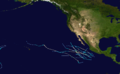
Overall, the 1980 season was slightly below the long-term average, with 16 tropical cyclones forming. Of those, 15 were named, 7 reached hurricane intensity, and only 3 became major hurricanes by attaining category 3 status or higher on the Saffir–Simpson scale. [3] All eastern Pacific systems this year formed in the eastern Pacific proper and two storms crossed into the central Pacific: Carmen from the west and Kay from the east. [4] The season had an early start when Carmen crossed over the International Date Line in April. [4] The strongest storm of this season is Hurricane Kay, peaking at 140 mph (225 km/h). Kay lasted for fourteen and a half days, which was the fifth-longest-lasting Pacific hurricane at the time.

Season summary

Saffir-Simpson Hurricane Scale1980 Pacific hurricane season

The 1980 Pacific hurricane season began on April 5, 1980, with the crossing of the International Date Line by Tropical Storm Carmen [4] and ended with the dissipation of Tropical Depression Newton on October 29. [3] Of the sixteen tropical cyclones that in the eastern north Pacific Ocean during 1980, one was a tropical depression, eight were tropical storms, [4] [3] and seven were hurricanes, of which three were major hurricanes of Category or higher on the Saffir–Simpson scale. Of these systems, all except one tropical storm formed east of 140°W in the eastern Pacific proper. [3] These totals are below the long-term average of fifteen tropical storms, nine hurricanes, and four major hurricanes. [5] Two tropical cyclones existed in the central Pacific, both of which crossed in from other tropical cyclone basins. [4] This total is below the average of four or five tropical cyclones per year. [1]

Systems

Tropical Storm Carmen

Tropical storm (SSHWS)
Carmen 1980-04-07 0015Z.png   Carmen 1980 track.png
DurationApril 4 – April 9
Peak intensity50 mph (85 km/h) (1-min);

On April 4, a tropical depression formed just east of the International Date Line. [6] The Joint Typhoon Warning Center (JTWC) designated it Tropical Depression 02W. As it moved generally northwestwards, the depression, strengthened into a tropical storm just before crossing the Date Line, at which time JTWC named the storm Carmen. [7] After peaking with maximum sustained winds of 70 mph (110 km/h) on April 6. Carmen recurved northeast and crossed the Date Line again, entering the central Pacific on April 7. The JTWC subsequently relinquished responsibility to the Central Pacific Hurricane Center. Carmen lost its initial motion and stalled in the area, ultimately weakening into a tropical depression on April 8. The depression dissipated the following day and the remnant low returned to the western Pacific. [4]

Carmen caused no deaths or damage in the Central Pacific Hurricane Center's area of responsibility. [4] It is the only known tropical cyclone in the central Pacific to exist in April. [8] In addition, it was the first northern hemisphere tropical cyclone to cross the dateline from west to east since Tropical Storm Virginia in 1968. [8]

Hurricane Agatha

Category 3 hurricane (SSHWS)
Agatha 1980-06-11 2345Z.png   Agatha 1980 track.png
DurationJune 9 – June 15
Peak intensity115 mph (185 km/h) (1-min);

Agatha originated from a tropical depression that formed 400 mi (640 km) south-southwest of Acapulco on June 9. After becoming better organized, EPHC upgraded the depression into a tropical storm later that day, giving it the name Agatha. The storm turned north then northwest and strengthened into a hurricane. On June 12, Agatha reached its peak intensity with maximum sustained winds of 115 mph (185 km/h), a category 3 hurricane on the Saffir–Simpson hurricane wind scale. After entering an area with cooler sea surface temperature and stable air, Agatha steadily weakened into a tropical storm on June 13 and a tropical depression on June 14. The EPHC issued the last advisory on Agatha on the following day as Agatha rapidly dissipated. [2]

Tropical Storm Blas

Tropical storm (SSHWS)
Tropical Storm Blas 1980.png   Blas 1980 track.png
DurationJune 16 – June 19
Peak intensity60 mph (95 km/h) (1-min);

A disturbance south-southwest of Acapulco developed a circulation and was designated Tropical Storm Blas on June 16. It headed northwest, and intensified, peaking in windspeed that same day. The cyclone then steadily weakened and dissipated on June 19, twelve hours after weakening into a tropical depression. [2]

Tropical Depression Three

Tropical depression (SSHWS)
TD3-E80.jpg  
DurationJune 17 – June 19
Peak intensity35 mph (55 km/h) (1-min);

A disturbance south of Acapulco developed into a tropical depression on June 17. It moved northwest and then west, and never strengthened much. The tropical cyclone dissipated on June 19 after moving over cooler waters. [2]

Hurricane Celia

Category 1 hurricane (SSHWS)
Celia 1980-06-27 2245Z.png   Celia 1980 track.png
DurationJune 25 – June 29
Peak intensity75 mph (120 km/h) (1-min);

A tropical disturbance moving west-northwestward organized into a tropical depression on June 25. It quickly strengthened to Tropical Storm Celia. Celia intensified into a hurricane on June 26 and reached its peak intensity from June 26 to June 28. Celia then curved to the northwest as it wheeled around the edge of a ridge. Celia weakened into a tropical storm on June 28, a depression on June 29, and dissipated just after that. It remnants remained, and cloudiness and moisture associated with the cyclone were carried into the Continental United States by an upper-level trough. [2]

Celia"s remnants and moisture brought rain to Santa Barbara County, California, on the last two days of June. [9] Other than that, Celia caused no impact. [2]

Tropical Storm Darby

Tropical storm (SSHWS)
Tropical Storm Darby 1980.png   Darby 1980 track.png
DurationJuly 1 – July 3
Peak intensity50 mph (85 km/h) (1-min);

On July 1, a westward-moving tropical disturbance located to the southwest of Acapulco organized into a tropical depression. The next day, it intensified into a tropical storm as it briefly jogged to the north. Darby peaked in wind speed just after that. It then weakened into a depression on July 3 and dissipated later that day. [2]

Tropical Storm Estelle

Tropical storm (SSHWS)
Estelle Jul 12 1980 0600Z.png   Estelle 1980 track.png
DurationJuly 12 – July 13
Peak intensity45 mph (75 km/h) (1-min);

An area of disturbed weather developed gale-force winds and a cyclonic circulation and was upgraded directly to tropical storm status on July 12. Estelle's winds peaked in velocity just after that. The cyclone then steadily weakened as it curved to the west-northwest. Estelle dissipated on July 13. [2] Estelle did not affect land. No damage or casualties were attributed to this tropical cyclone. [2]

Tropical Storm Frank

Tropical storm (SSHWS)
Tropical Storm Frank 1980.png   Frank 1980 track.png
DurationJuly 18 – July 22
Peak intensity50 mph (85 km/h) (1-min);

A tropical disturbance northeast of Clipperton organized into a tropical depression on July 18. Heading northwestwards, it intensified into a tropical storm on July 20. Frank reached its maximum wind speed shortly after that. The cyclone then turned to the west and gradually weakened, dissipating on July 22. [2]

Hurricane Georgette

Category 1 hurricane (SSHWS)
Hurricane Georgette 1980.png   Georgette 1980 track.png
DurationJuly 28 – July 31
Peak intensity75 mph (120 km/h) (1-min);

A tropical disturbance formed southwest of Acapulco on July 26. The disturbance was then upgraded to a tropical depression on July 28. The cyclone headed northwest. It intensified into a tropical storm on July 29. That same day, Georgette was briefly a hurricane. The cyclone turned to the west and weakened, dissipating on July 31. [2]

Hurricane Howard

Category 2 hurricane (SSHWS)
Howard Aug 4 1980 1506Z.png   Howard 1980 track.png
DurationJuly 31 – August 7
Peak intensity105 mph (165 km/h) (1-min);

A tropical disturbance south of Acapulco developed into a tropical depression on July 31. It headed west, and then gradually curved to the northwest as it paralleled the coast of Mexico. The cyclone became a storm shortly after forming, a hurricane on August 2, and peaked in windspeed on August 4. It then steadily weakened after that, and dissipated over cool waters shortly after becoming a tropical depression on August 7. [2] Howard threatened the coasts of Southern California and the northern part of the Baja California Peninsula, but in the end, never approached land. [2]

Hurricane Isis

Category 2 hurricane (SSHWS)
08-08-1980-1800z-ISIS.png   Isis 1980 track.png
DurationAugust 5 – August 11
Peak intensity100 mph (155 km/h) (1-min);

A tropical disturbance south of Acapulco developed into a tropical depression on August 5 and a tropical storm the next day. Isis headed generally west-northwest and peaked as a Category 2 hurricane on August 8. Isis then weakened, becoming a tropical storm on August 10, turning to the west, and dissipating the next day. [2]

Hurricane Javier

Category 3 hurricane (SSHWS)
Hurricane Javier Aug 24 1980 1800Z.jpg   Javier 1980 track.png
DurationAugust 22 – August 29
Peak intensity115 mph (185 km/h) (1-min);

An area of disturbed weather south of the Gulf of Tehuantepec became a tropical depression on August 22 and a storm the next day. Javier became a hurricane on August 24 and peaked as a major hurricane on August 25. Javier then weakened, becoming a tropical storm on August 27 and a storm the next day. It dissipated on August 29, having moved west-northwest for almost its entire life. [2]

Hurricane Kay

Category 4 hurricane (SSHWS)
Hurricane Kay Sep 18 1980 1700Z.jpg   Kay 1980 track.png
DurationSeptember 16 – September 30
Peak intensity140 mph (220 km/h) (1-min);

A tropical disturbance south of Acapulco developed into a tropical depression on September 16 and a tropical storm later that day. Kay headed in an irregular but generally west-northwest path out to sea. Kay strengthened into a hurricane on September 17. It continued strengthening and reached its peak as a Category 4 hurricane on the Saffir–Simpson scale on September 18. Kay then slowly weakened and was a tropical storm by September 20. Kay's forward motion slowed as it neared the central Pacific. It restrengthened into a hurricane on September 23, crossed 140°W, and entered the Central Pacific Hurricane Center's area of responsibility the next day. [2] Kay executed a small anticyclonic loop, and then began weakening again. It became a tropical storm again on September 27, and a depression two days later. The cyclone dissipated on September 30 while located north of the Hawaiian Islands. [4] Kay did not effect land, causing no damage or casualties. [2] It was the strongest tropical cyclone of the season at 140 mph (225 km/h). Kay lasted for 14.5 days, enough to make it the fifth-longest-lasting Pacific hurricane at the time. [4]

Tropical Storm Lester

Tropical storm (SSHWS)
Lester Sept 23 1980 1502Z.png   Lester 1980 track.png
DurationSeptember 21 – September 25
Peak intensity40 mph (65 km/h) (1-min);

A westward-moving disturbance south of Acapulco strengthened into a tropical depression on September 21. Continuing on its path, it intensified into Tropical Storm Lester on September 23. Lester's motion then slowed down, and it spun about in the open ocean until it dissipated on September 25. [2]

Tropical Storm Madeline

Tropical storm (SSHWS)
Tropical Storm Madeline 1980.png   Madeline 1980 track.png
DurationOctober 11 – October 12
Peak intensity50 mph (85 km/h) (1-min);

A disturbance east of Clipperton became a tropical depression and then a tropical storm. It headed northwest and weakened into a depression on October 12. It dissipated shortly afterward. [2]

Tropical Storm Newton

Tropical storm (SSHWS)
Tropical Storm Newton 1980.png   Newton 1980 track.png
DurationOctober 28 – October 29
Peak intensity40 mph (65 km/h) (1-min);

An area of disturbed weather southeast of Socorro Island became a tropical storm on October 28. It headed northeast and approached the coast of Mexico. However, an area of high wind shear and cool waters destroyed the cyclone on October 29, before it could reach the coast. [2] Newton was the tropical cyclone that came closest to making landfall this season. However, no impact was reported. [2]

Storm names

The following list of names was used for named storms that formed in the North Pacific Ocean east of 140°W in 1980. [10] Most of these names were used for the first time, except for Agatha, Estelle, Georgette, and Madeline, which were previously used in the old four-year lists. [11] No names were retired from this list following the season, and it was next used for the 1986 season. [12]

  • Agatha
  • Blas
  • Celia
  • Darby
  • Estelle
  • Frank
  • Georgette
  • Howard
  • Isis
  • Javier
  • Kay*
  • Lester
  • Madeline
  • Newton
  • Orlene (unused)
  • Paine (unused)
  • Roslyn (unused)
  • Seymour (unused)
  • Tina (unused)
  • Virgil (unused)
  • Winifred (unused)

The following list of names was in place for naming storms that formed in the North Pacific from 140°W to the International Date Line in 1980. [10] It was one of five lists of Hawaiian names using the 12 letters of the Hawaiian alphabet. These sets of names were to be cycled on an annual rotation basis beginning with the "A" name each year. [13] It went unused however, as Carman was named from the western Pacific typhoon name list by the Joint Typhoon Warning Center due to its proximity to the Date Line at time of formation. [7] One named storm in the table above crossed into the area from the east during the season (*). [6]

  • Akoni (unused)
  • Eme (unused)
  • Halola (unused)
  • Iune (unused)
  • Kika (unused)
  • Luke (unused)
  • Malulani (unused)
  • Napua (unused)
  • Oliwa (unused)
  • Puamele (unused)
  • Uleki (unused)
  • Wila (unused)

See also

Related Research Articles

<span class="mw-page-title-main">2004 Pacific hurricane season</span> Hurricane season in the Pacific Ocean

The 2004 Pacific hurricane season was unusual in that no tropical cyclones of at least tropical storm intensity made landfall, the first such occurrence since 1991. The season was also below-average in terms of named storms and hurricanes, near-average in terms of major hurricanes. The season officially began on May 15 in the eastern Pacific, and on June 1 in the central Pacific; it officially ended in both basins on November 30. These dates conventionally delimit the period during each year when a majority of tropical cyclones form. The season was reflected by an accumulated cyclone energy (ACE) index of 71 units.

<span class="mw-page-title-main">1998 Pacific hurricane season</span> Hurricane season in the Pacific Ocean

The 1998 Pacific hurricane season was a fairly average Pacific hurricane season. Despite this, it had nine hurricanes and six major hurricanes, which was well above average. The season officially started on May 15 in the eastern Pacific and on June 1 in the central Pacific, and ended on November 30; these dates conventionally delimit the period during which most tropical cyclones form in that region. The first tropical cyclone developed on June 11, about ten days later than the normal start of the season. The final storm of the year, Hurricane Madeline, dissipated on October 20. Storm activity in the Central Pacific Hurricane Center's warning zone was low, with just one tropical depression observed in the region. Two tropical cyclones from the eastern Pacific also entered the central Pacific; the former did so as a hurricane.

<span class="mw-page-title-main">1992 Pacific hurricane season</span> Hurricane season in the Pacific Ocean

The 1992 Pacific hurricane season is the most active Pacific hurricane season on record, featuring 27 named storms. The season also produced the second-highest ACE value on record in the basin, only surpassed by the 2018 season. The 1992 season officially started on May 15 in the eastern Pacific, and on June 1 in the central Pacific, and lasted until November 30. These dates conventionally delimit the period of each year when most tropical cyclones form in the northeastern Pacific Ocean. However, tropical cyclogenesis is possible at any time of the year, as demonstrated by the development of Hurricane Ekeka on January 28, and Tropical Storm Hali two months later.

<span class="mw-page-title-main">1991 Pacific hurricane season</span> Hurricane season in the Pacific Ocean

The 1991 Pacific hurricane season was a near-average Pacific hurricane season. The worst storm this year was Tropical Storm Ignacio, which killed 23 people in Mexico and injured 40 others. Elsewhere, Hurricane Fefa caused flooding in Hawaii. Hurricane Kevin was the strongest system of the season and became the then longest-lasting hurricane in the eastern north Pacific basin at the time, and Hurricane Nora was the strongest November storm to that point. The season officially started on May 15, 1991, in the eastern Pacific, and on June 1, 1991, in the central Pacific. It lasted until November 30, 1991, in both basins. These dates conventionally delimit the period of each year when most tropical cyclones form in the northeastern Pacific Ocean.

<span class="mw-page-title-main">1988 Pacific hurricane season</span> Hurricane season in the Pacific Ocean

The 1988 Pacific hurricane season was the least active Pacific hurricane season since 1981. It officially began May 15, in the eastern Pacific, and June 1, in the central Pacific and lasted until November 30. These dates conventionally delimit the period of each year when most tropical cyclones form in the northeastern Pacific Ocean. The first named storm, Tropical Storm Aletta, formed on June 16, and the last-named storm, Tropical Storm Miriam, was previously named Hurricane Joan in the Atlantic Ocean before crossing Central America and re-emerging in the eastern Pacific; Miriam continued westward and dissipated on November 2.

<span class="mw-page-title-main">1987 Pacific hurricane season</span> Hurricane season in the Pacific Ocean

The 1987 Pacific hurricane season was the last year in which the Eastern Pacific Hurricane Center was the primary warning center for tropical cyclones in the eastern Pacific Ocean. The season officially started May 15, 1987, in the eastern Pacific, and June 1, 1987, in the central Pacific, and lasted until November 30, 1987. These dates conventionally delimit the period of each year when the vast majority of tropical cyclones form in the northeastern Pacific Ocean.

<span class="mw-page-title-main">1986 Pacific hurricane season</span> Hurricane season in the Pacific Ocean

The 1986 Pacific hurricane season featured several tropical cyclones that contributed to significant flooding to the Central United States. The hurricane season officially started May 15, 1986, in the eastern Pacific, and June 1, 1986 in the central Pacific, and lasted until November 30, 1986 in both regions. These dates conventionally delimit the period of each year when most tropical cyclones form in the northeastern Pacific Ocean. A total of 17 named storms and 9 hurricanes developed during the season; this is slightly above the averages of 15 named storms and 8 hurricanes, respectively. In addition, 26 tropical depressions formed in the eastern Pacific during 1986, which, at the time, was the second most ever recorded; only the 1982 Pacific hurricane season saw a higher total.

<span class="mw-page-title-main">1985 Pacific hurricane season</span> Hurricane season in the Pacific Ocean

The 1985 Pacific hurricane season is the third-most active Pacific hurricane season on record. It officially started on May 15, 1985, in the eastern Pacific, and on June 1, 1985, in the central Pacific, and lasted until November 30, 1985. These dates conventionally delimit the period of each year when most tropical cyclones form in the northeastern Pacific Ocean. At the time, the 1985 season was the most active on record in the eastern north Pacific, with 28 tropical cyclones forming. Of those, 24 were named, 13 reached hurricane intensity, and 8 became major hurricanes by attaining Category 3 status or higher on the Saffir–Simpson scale. At that time, the 24 named storms was a record; however, this record was broken seven years later in 1992, and was therefore recognized as the second busiest season within the basin, until it was surpassed exactly thirty years later by the 2015 season.

<span class="mw-page-title-main">1982 Pacific hurricane season</span> Hurricane season in the Pacific Ocean

The 1982 Pacific hurricane season was, at the time, the most active Pacific hurricane season on record, with 23 named storms. The season officially started on May 15 in the eastern Pacific basin and June 1 in the central Pacific basin. Both basins' seasons ended on November 30. These dates conventionally delimit the period during which most tropical cyclones form in the northeastern Pacific Ocean. The first tropical cyclone of the season, Tropical Storm Aletta, formed on May 20, and the final one of the season, Hurricane Iwa, dissipated on November 25.

<span class="mw-page-title-main">1981 Pacific hurricane season</span> Hurricane season in the Pacific Ocean

The 1981 Pacific hurricane season was a slightly below average Pacific hurricane season. The season officially started on May 15 in the eastern Pacific basin and June 1 in the central Pacific basin. Both basins' seasons ended on November 30; these dates conventionally delimit the period during which most tropical cyclones form in the northeastern Pacific Ocean. The first tropical cyclone of the season was designated on May 30, and the final storm of the season, Hurricane Otis, dissipated on October 30. The season produced fifteen named storms and a total of eight hurricanes, which was near normal. However, the total of one major hurricane was below the average of three.

<span class="mw-page-title-main">1979 Pacific hurricane season</span> Hurricane season in the Pacific Ocean

The 1979 Pacific hurricane season was an inactive North Pacific hurricane season, featuring 10 named storms, 6 hurricanes, and 4 major hurricanes. All tropical cyclone activity this season was confined to the Eastern Pacific, east of 140°W. For the first time since 1977, no tropical cyclones formed in, or entered into the Central Pacific, between 140°W and the International Date Line.

<span class="mw-page-title-main">1976 Pacific hurricane season</span> Hurricane season in the Pacific Ocean

The 1976 Pacific hurricane season was a very deadly and costly season. Hurricanes Kathleen, Liza, and Madeline were the most notable storms this year. Hurricane Kathleen caused death and destruction in California and Arizona due to flooding. Hurricane Liza was the deadliest storm of the season when it killed over 600 people in Mexico. Hurricane Madeline is notable for being one of the most intense Pacific hurricanes at landfall.

<span class="mw-page-title-main">1975 Pacific hurricane season</span> Hurricane season in the Pacific Ocean

The 1975 Pacific hurricane season officially started May 15, 1975, in the eastern Pacific, and June 1, 1975, in the central Pacific, and lasted until November 30, 1975. These dates conventionally delimit the period of each year when most tropical cyclones form in the northeast Pacific Ocean.

<span class="mw-page-title-main">1978 Pacific hurricane season</span> Hurricane season in the Pacific Ocean

The 1978 Pacific hurricane season was the first Pacific hurricane season to use both masculine and feminine names for tropical cyclones. It also began the modern practice of utilizing naming lists every six years. Despite lacking an El Niño, a common driver of enhanced activity in the East and Central Pacific basins, the 1978 season was active. It featured 19 named storms, 14 hurricanes, and 7 major hurricanes, the latter of which are Category 3 or stronger cyclones on the Saffir–Simpson scale. Within the confines of the Central Pacific basin, located between the International Date Line and 140°W, 13 tropical cyclones or their remnants were observed by forecasters at the Central Pacific Hurricane Center, a record number of occurrences at the time. Seasonal activity began on May 30 and ended on October 21, within the limits of a traditional hurricane season which begins on May 15 in the East Pacific and June 1 in the Central Pacific. The season ends on November 30 in both basins. These dates conventionally delimit the period during each year when most tropical cyclones form.

<span class="mw-page-title-main">1971 Pacific hurricane season</span> Hurricane season in the Pacific Ocean

The 1971 Pacific hurricane season began on May 15, 1971 in the eastern Pacific, and on June 1, 1971 in the Central Pacific ; both ended on November 30, 1971. These dates, adopted by convention, historically describe the period in each year when most tropical cyclogenesis occurs in these regions of the Pacific. It was the first year that continuous Weather satellite coverage existed over the entire Central Pacific. As such, this season is often viewed as the start year for modern reliable tropical cyclone data in the Pacific Ocean.

<span class="mw-page-title-main">1968 Pacific hurricane season</span> Hurricane season in the Pacific Ocean

The 1968 Pacific hurricane season ties the record for having the most active August in terms of tropical storms. It officially started on May 15, 1968, in the eastern Pacific and June 1 in the central Pacific and lasted until November 30, 1968. These dates conventionally delimit the period of each year when most tropical cyclones form in the northeastern Pacific Ocean.

<span class="mw-page-title-main">2011 Pacific hurricane season</span> Hurricane season in the Pacific Ocean

The 2011 Pacific hurricane season was a below average season in terms of named storms, although it had an above average number of hurricanes and major hurricanes. During the season, 13 tropical depressions formed along with 11 tropical storms, 10 hurricanes and 6 major hurricanes. The season officially began on May 15 in the East Pacific Ocean, and on June 1 in the Central Pacific; they both ended on November 30. These dates conventionally delimit the period of each year when most tropical cyclones form in the Pacific basin. The season's first cyclone, Hurricane Adrian formed on June 7, and the last, Hurricane Kenneth, dissipated on November 25.

<span class="mw-page-title-main">2016 Pacific hurricane season</span> Hurricane season in the Pacific Ocean

The 2016 Pacific hurricane season was tied as the fifth-most active Pacific hurricane season on record, alongside the 2014 season. Throughout the course of the year, a total of 22 named storms, 13 hurricanes and six major hurricanes were observed within the basin. Although the season was very active, it was considerably less active than the previous season, with large gaps of inactivity at the beginning and towards the end of the season. It officially started on May 15 in the Eastern Pacific, and on June 1 in the Central Pacific ; they both ended on November 30. These dates conventionally delimit the period of each year when most tropical cyclones form in these regions of the Pacific Ocean. However, tropical development is possible at any time of the year, as demonstrated by the formation of Hurricane Pali on January 7, the earliest Central Pacific tropical cyclone on record. After Pali, however, no tropical cyclones developed in either region until a short-lived depression on June 6. Also, there were no additional named storms until July 2, when Tropical Storm Agatha formed, becoming the latest first-named Eastern Pacific tropical storm since Tropical Storm Ava in 1969.

<span class="mw-page-title-main">2022 Pacific hurricane season</span> Hurricane season in the Pacific Ocean

The 2022 Pacific hurricane season was an active hurricane season in the eastern North Pacific basin, with nineteen named storms, ten hurricanes, and four major hurricanes. Two of the storms crossed into the basin from the Atlantic. In the central North Pacific basin, no tropical cyclones formed. The season officially began on May 15 in the eastern Pacific, and on June 1 in the central; both ended on November 30. These dates historically describe the period each year when most tropical cyclogenesis occurs in these regions of the Pacific and are adopted by convention.

<span class="mw-page-title-main">Tropical cyclones in 2022</span>

During 2022, tropical cyclones formed in seven major bodies of water, commonly known as tropical cyclone basins. Tropical cyclones were named by various weather agencies when they attained maximum sustained winds of 35 knots. During the year, 133 systems formed, of which 87 were named. The strongest storm to form was Typhoon Nanmadol, with minimum pressure of 910 hPa (26.87 inHg). The deadliest tropical cyclone was Tropical Storm Megi, which caused 214 fatalities in the Philippines, while the costliest was Hurricane Ian, which had an estimated damage total of at least $113.1 billion after affecting Trinidad and Tobago, Venezuela, Colombia, the western part of the Greater Antilles and Southeast United States. Throughout 2022, eighteen major tropical cyclones formed, including three Category 5 tropical cyclones Saffir–Simpson scale (SSHWS) during the year. The accumulated cyclone energy (ACE) index for the 2022, as calculated by Colorado State University (CSU) was 559.6 units overall.

References

  1. 1 2 "Frequently Asked Questions". Central Pacific Hurricane Center. Archived from the original on 6 April 2010. Retrieved 2010-04-09.
  2. 1 2 3 4 5 6 7 8 9 10 11 12 13 14 15 16 17 18 19 20 21 Gunther, Emil B. (August 1981). "Eastern North Pacific Tropical Cyclones of 1980". Monthly Weather Review. 109 (8): 1701–1712. Bibcode:1981MWRv..109.1701G. doi: 10.1175/1520-0493(1981)109<1701:ENPTCO>2.0.CO;2 .
  3. 1 2 3 4 National Hurricane Center; Hurricane Research Division; Central Pacific Hurricane Center (April 4, 2023). "The Northeast and North Central Pacific hurricane database 1949–2022". United States National Oceanic and Atmospheric Administration's National Weather Service. A guide on how to read the database is available here. PD-icon.svg This article incorporates text from this source, which is in the public domain.
  4. 1 2 3 4 5 6 7 8 9 "The 1980 Central Pacific Tropical Cyclone Season". Central Pacific Hurricane Center . Retrieved 2010-04-09.
  5. "Background Information: Eastern Pacific Hurricane Season". Climate Prediction Center . Retrieved 2010-04-09.
  6. 1 2 Pao-Shin Chu; Peng Wu (2008). Climatic Atlas of Tropical Cyclone Tracks over the Central North Pacific (PDF) (Report). University of Hawaii-Manoa. Retrieved August 2, 2015.
  7. 1 2 1980 Annual Tropical Cyclone Report (PDF) (Report). San Francisco, California: U.S. Naval Oceanography Command Center/Joint Typhoon Warning Center. pp. 20–21. Retrieved February 28, 2024.
  8. 1 2 "Previous Tropical Systems in the Central Pacific". Central Pacific Hurricane Center. 2010. Archived from the original on March 25, 2010. Retrieved 2013-07-05.
  9. Jack Williams (2005-05-17). "Background: California's Tropical Storms". USA Today . Retrieved 2010-04-12.
  10. 1 2 National Hurricane Operations Plan (PDF) (Report). Washington, D.C.: NOAA Office of the Federal Coordinator for Meteorological Services and Supporting Research. May 1980. pp. 12, 15–16. Retrieved January 14, 2024.
  11. "Eastern North Pacific Tropical Cyclone Name History". Atlantic Tropical Weather Center. Archived from the original on September 29, 2007. Retrieved February 28, 2024.
  12. "Andrew, Agatha, top 1986 list". The Gadsden Times . Gadsden, Alabama. May 23, 1986. Retrieved December 23, 2009.
  13. Padgett, Gary (July 11, 2008). "Monthly Global Tropical Cyclone Summary: November 2007 First Installment". Australian Severe Weather. Retrieved February 28, 2024.