1987 Pacific typhoon season

Last updated
1987 Pacific typhoon season
1987 Pacific typhoon season summary map.png
Season summary map
Seasonal boundaries
First system formedJanuary 7, 1987
Last system dissipatedDecember 20, 1987
Strongest storm
Name Betty
  Maximum winds205 km/h (125 mph)
(10-minute sustained)
  Lowest pressure890 hPa (mbar)
Seasonal statistics
Total depressions32
Total storms23
Typhoons17
Super typhoons6 (unofficial)
Total fatalities1,402 total
Total damage> $1.3 billion (1987 USD)
Related articles
Pacific typhoon seasons
1985, 1986, 1987, 1988, 1989

The 1987 Pacific typhoon season was a below average season, though it featured a relatively high amount of typhoons. It had no official bounds; it ran year-round in 1987, but most tropical cyclones formed between May and November. [1] Tropical storms that formed in the entire basin were assigned a name by the Joint Typhoon Warning Center. Tropical depressions that enter or form in the Philippine area of responsibility are assigned a name by the Philippine Atmospheric, Geophysical and Astronomical Services Administration or PAGASA. This can often result in the same storm having two names.

Contents

A total of 25 tropical cyclones formed this year in the Western Pacific, of which 24 became tropical storms. Of the 24, 17 storms reached typhoon intensity, of which 6 reached super typhoon strength.

Seasonal summary

Typhoon Nina (1987)Typhoon Lynn (1987)Typhoon Kelly (1987)Typhoon GeraldTyphoon Dinah (1987)Typhoon Cary (1987)Typhoon Betty (1987)Typhoon Alex (1987)Typhoon Thelma (1987)1987 Pacific typhoon season

A total of 25 tropical cyclones formed this year in the Western Pacific, of which 24 became tropical storms. Of the 24, 17 storms reached typhoon intensity, of which 6 reached super typhoon strength.

Systems

Typhoon Orchid (Auring)

Very strong typhoon (JMA)
Category 2 typhoon (SSHWS)
Orchid Jan 11 1987 0531Z.png   Orchid 1987 track.png
DurationJanuary 7 – January 14
Peak intensity165 km/h (105 mph) (10-min);
955  hPa  (mbar)

On January 3, a small and persistent area of thunderstorms near the International Date Line was first detected. [2] During the next few days, it slowly increased in organization and thunderstorm activity after which a small and ragged central dense overcast formed and upper-level outflow improved. [2] A Tropical Cyclone Formation Alert (TCFA) was issued late on January 7 for the disturbance. [2] The JTWC then issued their first warning on Tropical Depression 01W during the afternoon of January 7. [2] The next morning, on January 8, an aircraft reconnaissance mission reported tropical storm–winds and the depression was upgraded to a tropical storm and named Orchid. [2] Orchid continued to gradually strengthen until it reached its peak intensity of 110 mph (180 km/h) on January 11 as a small typhoon. [2] After reaching peak intensity, Orchid weakened rather quickly and by January 14, it had degenerated into an area of low pressure. [2]

Orchid caused "extensive damage" on Ulithi Atoll but no deaths were reported. [2] In the wake of the typhoon, the United States Federal Emergency Management Agency declared parts of the Federated States of Micronesia as a disaster area. [3]

Tropical Storm Percy

Tropical storm (JMA)
Tropical storm (SSHWS)
Percy Apr 11 1987 0608Z.png   Percy 1987 track.png
DurationApril 9 – April 16
Peak intensity85 km/h (50 mph) (10-min);
1000  hPa  (mbar)

During the first week of April, the typical northeasterly trades clashed with a Southern Hemisphere Westerly wind burst, creating an area of low pressure near the Caroline Islands. Gradual development occurred as it tracked westward, [4] and on April 9, the JMA upgraded the system into a tropical depression, [5] although the JTWC did not follow suit until April 11. Following data from a hurricane hunter aircraft that indicated that the depression was much stronger than expected, both the JTWC [4] and JMA upgraded the depression later on April 11, with the latter estimating a peak wind speed of 85 km/h (55 mph). [5] Almost immediately thereafter, Percy weakened rapidly, with the storm's center becoming exposed from the deep convection. [4] The JMA downgraded Percy into a tropical depression at 18:00 on April 11. [5] Thirty hours later, the JTWC discontinued warnings. [4] The JMA ceased tracking the storm while it was located near the northern tip of Luzon on April 16. [5]

Tropical Storm Ruth

Tropical storm (JMA)
Tropical storm (SSHWS)
Ruth Jun 18 1987 0724Z.png   Ruth 1987 track.png
DurationJune 17 – June 19
Peak intensity85 km/h (50 mph) (10-min);
992  hPa  (mbar)

According to the JMA, a tropical depression developed on June 17 [5] around 445 km (275 mi) southeast of Hong Kong, [4] becoming the first tropical cyclone of the season to develop in the South China Sea. [6] Its convective structure gradually improved as the depression tracked west-northwest under the influence of a ridge to its north, and at 00:00 UTC on June 18, the JTWC classified the system as a tropical depression. [4] The JMA upgraded the depression into a tropical storm six hours later, while also estimating a peak wind speed of 85 km/h (55 mph). [5] The JTWC did not follow suit until at 18:00 UTC on June 18, when satellite estimated supported tropical storm intensity. [4] Early on June 19, both the JTWC and JMA downgraded Ruth into a depression while it interacted with the southern China coast. [4] [5] Ruth dissipated inland later that day. [4]

According to media outlets, Ruth inflicted widespread damage and casualties in southwest Guangdong and southeast Guangxi. In Guangdong, about 113,000 ha (279,230 acres) of farmland were inundated and 63,000 ha (155,675 acres) of banana plantations were damaged or destroyed. Extensive irrigation works were also damaged and 17 cows were killed. There, seven people were dead and eighty-six others were injured. Over 45,000 houses collapsed while more than 210,000 dwellings were damaged. Approximately 350 bridges were destroyed. In Guangxi, three deaths and twenty-six injuries were reported. As a result of the heavy rain, 45 bridges and over 780 houses sustained damaged. In addition, over 7,000 ha (17,295 acres) of farmland were flooded. The railway service was also temporarily disrupted. In Hong Kong, damage was minimal and only one structure was demolished. [6]

Typhoon Sperry (Bebeng)

Typhoon (JMA)
Category 1 typhoon (SSHWS)
Sperry Jun 29 1987 1037Z.png   Sperry 1987 track.png
DurationJune 26 – July 1
Peak intensity120 km/h (75 mph) (10-min);
980  hPa  (mbar)

The origins of Typhoon Sperry can be traced back to a weak surface circulation that formed on June 24 as part of the monsoon trough 370 km (230 mi) northwest of Truk. A second area of disturbed weather subsequently developed 400 km (250 mi) east of the Marshall Islands. The two areas consolidated into one on June 25, even though further development was initially slow to occur due to strong wind shear created by a tropical upper tropospheric trough near Wake Island. On June 25, the storm began to show signs of organization while tracking northwest; [4] however, the JMA did not upgrade the system into a tropical depression until 00:00 UTC on June 26. [5] On the next day, both the JTWC and JMA classified the system as Tropical Storm Sperry after the low-level center became better defined and the storm developed a central dense overcast – a large mass of deep convection. [4] [5] Later on June 28, Sperry was upgraded into a severe tropical storm by the JMA. [5] On the next day, both agencies upgraded Sperry into a typhoon, the second of the season, based on reports from hurricane hunters. [4] At noon on June 28, the JTWC and JMA reported that Sperry peaked in strength; the agencies estimated winds of 135 and 120 km/h (85 and 75 mph) respectively at this time. [4] [5] By June 29, Sperry began to approach a break in the ridge as well as a cold front, causing the storm to recurve to the northeast, becoming the first storm of the season to interact with mid-latitude westerlies. Thunderstorm activity quickly became displaced from the center due to increased wind shear, [4] and the JMA downgraded Sperry into a severe tropical storm at 00:00 UTC on June 30. [5] On the next day, both the JTWC and JMA declared Sperry an extratropical cyclone, [4] [5] although its remains later merged with a frontal zone. [4]

Typhoon Thelma (Katring)

Very strong typhoon (JMA)
Category 4 super typhoon (SSHWS)
Thelma 1987-07-11 0636Z.png   Thelma 1987 track.png
DurationJuly 6 – July 16
Peak intensity185 km/h (115 mph) (10-min);
915  hPa  (mbar)

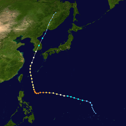
Thelma was first designated by the JMA as a tropical depression on July 7. [5] After moving north, Thelma turned west, while remaining poorly organized. [4] It finally attained typhoon status on July 9, [5] soon after developing an eye, and began to intensify at a brisker clip, and on July 10, the JTWC upgraded Thelma into the first super typhoon of the season. [4] During the evening of July 10, Thelma attained maximum intensity [5] while well to the east of the Philippines. It also turned sharply northward in response to a trough while also slowly weakening. On July 15, Typhoon Thelma, now greatly reduced in intensity, struck the south coast of South Korea. The next day, Thelma rapidly dissipated, shortly after emerging into the Sea of Japan. [4] 138 people were killed by Thelma.

Severe Tropical Storm Vernon (Diding)

Severe tropical storm (JMA)
Category 1 typhoon (SSHWS)
Vernon Jul 20 1987 0000Z.png   Vernon 1987 track.png
DurationJuly 15 – July 22
Peak intensity110 km/h (70 mph) (10-min);
985  hPa  (mbar)

On July 14, an area of disturbed weather formed while embedded in the near-equatorial monsoon trough in the eastern Caroline Islands. A well-defined low level circulation quickly developed, but convective activity remained limited until July 16, [4] when both the JTWC and JMA upgraded the system into a tropical depression. [4] [5] Initially, the depression moved westwards towards the central Philippines while remaining disorganized. [4] The JMA upgraded Vernon into a tropical storm at noon on July 18, and a severe tropical storm 12 hours later. [5] At midday on July 1, the JTWC upgraded Vernon into a typhoon. Vernon began to track northwestward in the general direction of Taiwan. [4] On July 20, the JMA estimated that Vernon reached its peak intensity, with winds of 115 km/h (70 mph). [5] Shortly after its peak, Typhoon Vernon began to interact with the rugged terrain of Taiwan as it skirted the eastern shore and the JTWC and JMA estimated that Vera rapidly weakened to a tropical depression on July 21. [4] [5] Vernon dissipated in the East China Sea on July 22 after passing the northern tip of Taiwan. [4]

Typhoon Wynne (Gening)

Very strong typhoon (JMA)
Category 4 typhoon (SSHWS)
Wynne 1987-07-26 0534Z.png   Wynne 1987 track.png
DurationJuly 18 – August 1
Peak intensity185 km/h (115 mph) (10-min);
920  hPa  (mbar)

The initial disturbance that would become Typhoon Wynne formed east of the International Date Line on July 20. Embedded in an environment of moderate wind shear, the disturbance slowly became more organized while tracking west. [4] On July 21, the JMA classified the system as a tropical depression. [5] Both the JTWC and JMA upgraded the depression into Tropical Storm Wynne at 06:00 UTC on July 22. [4] [5] After Wynne developed a central dense overcast, a large mass of deep convection, [4] the JMA upgraded Wynne to a severe tropical storm midday on July 23. [5] Later that day, the JTWC upgraded Wynne into a typhoon while the typhoon passed over the northern Marianas island of Alamagan. On the next day, after the storm developed an eye, [4] the JMA followed suit and classified Wynne as a typhoon. [5] A smaller than average typhoon, Wynne turned west-northwest. By July 26, Wynne reached its maximum intensity, [4] with the JTWC reporting winds of 230 km/h (145 mph) and the JMA reporting winds of 185 km/h (115 mph). [4] [5] of 145 mph (233 km/h). As it rounded the western periphery of the subtropical ridge, the cyclone became sheared from the north, which caused the storm to weaken and its center to become exposed from the deep convection. Even so, it maintained typhoon intensity until July 30, [4] according to both agencies. [4] [5] Recurving east of Honshū, Wynne continued to weaken. [4] Both the JTWC and JMA determined that Wynne transitioned into an extratropical cyclone by the afternoon of July 31, [4] [5] although the JMA continued to track Wynne for five additional days. [5]

Prior to the arrival of the typhoon on Alamagan, a handful of people sought shelter. [7] All coconut trees and 90–100% of crops on islands of Alamagan and Agrihan were destroyed by the typhoon. [4] All structures on Alamgan were destroyed, including the radio tower, which was the island's communication to the rest of Saipan. However, there were no serious injuries [7] or deaths. [4]

Typhoon Alex (Etang)

Typhoon (JMA)
Category 1 typhoon (SSHWS)
Alex Jul 26 1987 0717Z.png   Alex 1987 track.png
DurationJuly 21 – July 30
Peak intensity120 km/h (75 mph) (10-min);
970  hPa  (mbar)

Alex hit Taiwan as a typhoon. By the night of July 28, Alex went extratropical low and dissipated 2 days later. Alex killed a total of 126 people.

Typhoon Betty (Herming)

Violent typhoon (JMA)
Category 5 super typhoon (SSHWS)
Betty 1987-08-11 0000Z.png   Betty 1987 track.png
DurationAugust 7 – August 17
Peak intensity205 km/h (125 mph) (10-min);
890  hPa  (mbar)

Typhoon Betty formed from the monsoon trough that, according to the JMA, spawned a tropical depression on August 8 while around positioned well to the east of the Philippines. [4] [5] It drifted northwestward, [4] becoming a tropical storm on August 9 and a typhoon on August 10. [5] Betty turned westward, where it rapidly intensified, becoming the second super typhoon of the season, before attaining peak intensity on August 11. The next day, Typhoon Betty made landfall in the central Philippines. Betty weakened rapidly over the country, but restrengthened somewhat over the South China Sea. Land interaction weakened Betty slightly before it hit central Vietnam on August 16. The next day, Betty dissipated. [4] Betty killed 92 people

Typhoon Cary (Ising)

Typhoon (JMA)
Category 2 typhoon (SSHWS)
Cary 1987-08-17 0639Z.png   Cary 1987 track.png
DurationAugust 7 – August 24
Peak intensity140 km/h (85 mph) (10-min);
960  hPa  (mbar)

Cary formed on the August 7th and started to move westward, the storm peaked to a Category 2 storm and struck the Philippines, this resulted in 25 casualties and $5.58 million of damage. The storm weakened inland Vietnam

JMA Tropical Storm Ten

Tropical storm (JMA)
JMA TS Aug 11 1987 0607Z.png   JMA TS 10 1987 track.png
DurationAugust 10 – August 13
Peak intensity65 km/h (40 mph) (10-min);
1006  hPa  (mbar)

This system was not tracked by the JTWC.

Typhoon Dinah (Luding)

Very strong typhoon (JMA)
Category 4 super typhoon (SSHWS)
Dinah 1987-08-26 0000Z.png   Dinah 1987 track.png
DurationAugust 19 – August 31
Peak intensity185 km/h (115 mph) (10-min);
915  hPa  (mbar)

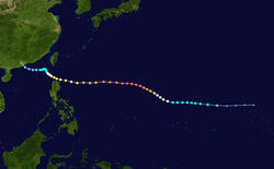
An area of low pressure developed near Guam on August 19, and on August 21, the low reached tropical storm intensity as it moved generally west. Intensification was initially gradual, but Dinah became a typhoon early on August 24, and subsequently began to intensify at a faster pace. Dinah reached its highest strength on August 26 before turning northward on August 28 and into a less favorable conditions aloft, which prompted weakening. Dinah entered the Sea of Japan after passing near Okinawa on August 29, where Dinah leveled off in intensity. The system then began to recurved towards southwestern Japan, and after passing through the area, Dinah transitioned into an extratropical cyclone on August 31, although the remnants could be traced for four more days as it approached the International Date Line. Across Okinawa, one person was killed, six more were injured, eight homes were destroyed or seriously damaged, and 13 boats sunk or were damaged. Damage exceeded $1.3 million (1987 USD). On the island of Kyushu, 250 homes were flooded and about 450,000 homeowners lost power. Throughout Japan, eight people perished, and 89 were wounded. The typhoon destroyed nearly 40,000 dwellings and an additional 600 were flooded. In South Korea, 4,372 structures were destroyed, leaving more than 11,000 people homeless. Nationwide, the typhoon was responsible for flooding 80,000 hectares (200,000 acres) of crops. Property damage was estimated at $39.1 million.

Tropical Depression Ed

Tropical depression (JMA)
Tropical storm (SSHWS)
Ed 1987-08-26 0500Z.png   Ed 1987 track.png
DurationAugust 21 – August 29
Peak intensity65 km/h (40 mph) (1-min);
1006  hPa  (mbar)

Ed formed in the middle of West Pacific. The storm only peaked as a Tropical Depression, despite its length. Tropical Depression Ed then dissipated on 29 August.

Typhoon Gerald (Neneng)

Typhoon (JMA)
Category 3 typhoon (SSHWS)
Gerald 1987-09-09 0005Z.jpg   Gerald 1987 track.png
DurationSeptember 4 – September 11
Peak intensity150 km/h (90 mph) (10-min);
950  hPa  (mbar)

On September 4 a tropical depression formed east of Luzon from the monsoon trough. It remained embedded within the trough, and moved erratically, drifting northward to become a tropical storm late on the 4th. Gerald turned more to the northwest, reached typhoon strength on the 7th, and continued to intensify to a peak of 120 mph (190 km/h) on the 8th. It passed south of Taiwan, disrupting the circulation and weakening it as it continued to the west-northwest. Gerald hit southeast China as a 65 mph (105 km/h) tropical storm on the 10th, and dissipated the next day. Mudslides and torrential flooding up to 16 inches (410 mm) in some locations resulted in $131 million in damage (1987 USD) and 127 fatalities. [8]

Typhoon Freda

Violent typhoon (JMA)
Category 4 typhoon (SSHWS)
Freda 1987-09-10 0541Z.jpg   Freda 1987 track.png
DurationSeptember 4 – September 17
Peak intensity195 km/h (120 mph) (10-min);
915  hPa  (mbar)

Typhoon Freda developed from an active monsoon trough; the precursor disturbance to Freda was first noted on September 1. A low-level center first began evident two days later, [4] and on September 4, the JMA classified the disturbance as a tropical depression, [5] with the JTWC following suit at 18:00 UTc that day. After passing Guam, Freda began to intensify at a faster clip; [4] both the JTWC and JMA upgraded the depression into Tropical Storm Freda on the morning of September 5. [4] [5] Quasi-stationary, Freda steadily intensified, and following the appearance of a small eye on satellite imagery, [4] Freda was upgraded into a typhoon by both the JTWC and JMA. [4] [5] After executing a small counterclockwise loop, Freda turned northeast. [4] On September 10, the JTWC and JMA, based on Dvorak analysis, estimated that Freda reached its peak wind spreed, with winds of 235 and 195 km/h (145 and 120 mph) respectively. [4] [5] Typhoon Freda began to round the western periphery of a ridge, which caused the system to accelerate towards the north. The JTWC estimated that Freda weakened to a tropical storm during the evening hours of September 13; [4] however, the JMA maintained the storm at typhoon intensity for several additional days. [5] By September 16, Freda began to interact with a mid-level trough to the north, which resulted in a turn to the northeast. After bypassing Honshu, wind shear began to take toll on the system and Freda began to turn extratropical. [4] On September 17, the JTWC declared Freda extratropical, [4] with the JMA doing the same the following day. It was lasted noted on September 20. [5]

Due to the storms erratic motion during its early stages, Guam received two distinct periods of heavy rainfall from the storm. On September 4, the typhoon dropped 109.3 mm (4.30 in), and four days later, 635 mm (25.0 in) was recorded on the island, along with gale-force winds. Throughout the Mariana Islands, rough seas damaged coral reefs and eroded beaches, but there were no casualties. [4]

Typhoon Holly

Violent typhoon (JMA)
Category 5 super typhoon (SSHWS)
Holly Sep 9 1987 1800Z.png   Holly 1987 track.png
DurationSeptember 4 – September 15
Peak intensity205 km/h (125 mph) (10-min);
900  hPa  (mbar)

The final of a three storm tropical cyclone outbreak, Holly began as a poorly organized but persistent area of convection at the eastern edge of the monsoon trough, which was displaced a bit to the north of its climatological position. Tracking westward, the disturbance gradually organized due to low wind shear. Shower and thunderstorm activity developed over the center, [4] and at 00:00 UTC on September 5, the JMA classified the system as a tropical depression, [5] with the JTWC doing the same six hours later. Although only slight intensification was expected, the depression took advantage of the favorable conditions. A central dense overcast quickly developed, [4] and the JMA upgraded Holly into a severe tropical storm at noon on September 7 and a typhoon 12 hours later. [5] The JTWC also designated Holly a typhoon on September 7. [4] Following a 36-hour period of rapid deepening, the JMA estimated that Holly attained its peak intensity of 200 km/h (125 mph) midday on September 9. [5] Meanwhile, the JTWC estimated winds of 255 km/h (160 mph), making Holly a super typhoon. Around this time, Holly veered from northwestward to northward caused by a weakness in the subtropical ridge. Holly steadily weakened as its forward motion decreased. [4] On September 14, the JMA downgraded Holly to a severe tropical storm, [5] while the JTWC estimated that Holly transitioned into a subtropical cyclone that day. the JTWC declared Holly an extratropical cyclone on September 15, [4] with the JMA following suit two days later. The remnants of the typhoon lost its identity late on September 17. [5] Throughout its lifetime, Typhoon Holly had no effects on land. [4]

Typhoon Ian

Typhoon (JMA)
Category 3 typhoon (SSHWS)
Ian Sep 26 1987 0000Z.png   Ian 1987 track.png
DurationSeptember 22 – October 4
Peak intensity140 km/h (85 mph) (10-min);
955  hPa  (mbar)

Typhoon Ian began as broad and poorly organized tropical disturbance situated roughly 610 km (380 mi) east-northeast of Guam. At the time, the disturbance was embedded in the Western Pacific monsoon trough, which re-established itself after being disrupted by the previous tropical cyclone outbreak. Pressures in the area gradually fell start on September 21. Based on Dvorak classifications of T2.0/55 km/h (35 mph), [4] the JMA and JTWC both classified the disturbance as a tropical depression early on September 23. At 18:00 UTC that day, both agencies upgraded the depression into Tropical Storm Ian. [4] [5] Tracking westward, Ian strengthened at a climatological rate of one T number per day. [4] After Ian turned to the northwest, the JMA upgraded Ian into a severe tropical storm at 00:00 UTC on September 25. [5] Despite lacking an inner core, [4] Ian was believed to have attained typhoon intensity that same day by both the JTWC and JMA, [4] [5] and subsequently, entered a period of rapid deepening. The JTWC estimated that Ian deepened by 50 mph (80 km/h) over the next 24 hours. Data from the JTWC indicated that Ian peaked in intensity at 00:00 UTC on September 26, with winds of 200 km/h (125 mph). [4] The JMA suggested, however, the Ian's peak was much lower, with winds of 135 km/h (85 mph). [5] While leveling off in intensity, Ian's forward motion decreased as it tracked northward. The storm's slow motion caused the typhoon to upwell cold water, which contributed to a decrease in cloud top temperatures around the eye. On September 29, Ian began to recurve out to sea, in response to a shortwave trough passing north of the typhoon. [4] The JMA downgraded Ian to a severe tropical storm that evening. [5] The JTWC estimated that Ian transitioned into a subtropical cyclone on October 1, [4] and the next day, Ian was downgraded into a tropical storm by the JMA. [5] On October 4, Ian finally dissipated over 2,000 km (1,245 mi) to the east of Japan. [4]

Tropical Depression 17W

Tropical depression (JMA)
Tropical depression (SSHWS)
17W Sep 25 1987 0438Z.png   18-W 1987 track.png
DurationSeptember 25 – September 26
Peak intensity55 km/h (35 mph) (1-min);
1006  hPa  (mbar)

Typhoon Peke

Typhoon (JMA)
Category 3 typhoon (SSHWS)
Peke Sep 30 1987 0347Z.png   Peke 1987 track.png
DurationSeptember 28 (Entered basin) – October 3
Peak intensity150 km/h (90 mph) (10-min);
950  hPa  (mbar)

On September 28, Hurricane Peke crossed the International Date Line and was thus re-designated as Typhoon Peke at 00:00 UTC that day. [4] At the time of crossing, the JMA estimated winds of 145 km/h (90 mph) [5] while the JTWC estimated winds of 135 km/h (85 mph). [4] In response to improved circus outflow, Peke steadily intensified, and early on September 29, the JTWC estimated that Peke reached its peak velocity, with winds of 115 mph (185 km/h); [4] however, the JMA did not observe any strengthening. [5] The typhoon began to encounter drier air, which prevented further intensification and caused the storm to become less organized. Midday on September 30, Ian became to decelerate as the storm started a weakening trend. After briefly becoming quasi-stationary, Peke veered to the north-northeast, only to drift back to the southeast as the storm's low- and mid-level centers diverged. The JTWC stopped tracking the system on October 3, although its remnants lingered for another three and half days due to collapsed steered currents. [4] On October 7, the JMA ceased tracking Peke. [5]

Tropical Storm June

Tropical storm (JMA)
Tropical storm (SSHWS)
June 1987-09-30 0528Z.png   June 1987 track.png
DurationSeptember 27 – October 2
Peak intensity85 km/h (50 mph) (10-min);
992  hPa  (mbar)

The seventh and final tropical cyclone to form during the month of September, an area of disturbed weather developed on September 23 during the next four days, it failed to develop appreciably, [4] but on September 28, the JMA classified the disturbance as a tropical depression. [5] By September 30, shower and thunderstorm activity had increased considerably, [4] prompting both the JTWC and JMA to upgrade the system into a tropical storm. [4] [5] However, June's close proximity to the more powerful Typhoon Ian restricted June's outflow and inhibited further strengthening. Increased vertical wind shear caused the low-level center to become detached from the shower and thunderstorm activity and the JTWC issued their final warning on system at 00:00 UTC on October 1. [4] Despite this, the JMA estimated that June attained its peak intensity of 70 km/h (45 mph) around this time. The JMA finally downgraded June into a tropical depression on October 2. The JMA stopped tracking the system altogether that evening. [5]

Typhoon Kelly (Oniang)

Typhoon (JMA)
Category 2 typhoon (SSHWS)
Kelly Oct 15 1987 0608Z.png   Kelly 1987 track.png
DurationOctober 9 – October 17
Peak intensity140 km/h (85 mph) (10-min);
955  hPa  (mbar)

A tropical disturbance formed east of the southern Philippines on October 7. Moving north-northwest for much of its life cycle, the system became a tropical depression and strengthened into a tropical storm on October 11 and a typhoon on October 12. Recurving near the 26th parallel, Kelly struck southern Japan as a typhoon early on October 17 and rapidly transitioned into an extratropical cyclone later that day in the Sea of Japan. On Shikoku Island Kelly dropped 20 inches (510 mm) of rain, resulting floods and landslides killed 9 people. [9]

Typhoon Lynn (Pepang)

Violent typhoon (JMA)
Category 5 super typhoon (SSHWS)
Lynn 1987-10-20 0000Z.png   Lynn 1987 track.png
DurationOctober 14 – October 28
Peak intensity195 km/h (120 mph) (10-min);
920  hPa  (mbar)

Typhoon Lynn, having developed from the monsoon trough on October 15 over the open ocean, rapidly intensified to a 160 mph (260 km/h) super typhoon on the 19th and 20th. It crossed through the Mariana Islands, and steadily weakened as it continued westward. Lynn passed just north of Luzon on the 23rd, and upper-level winds weakened it to a tropical depression before it hit southern China on the 28th. Lynn's tight pressure gradient, in combination with a large high pressure area over China, caused heavy winds over Taiwan, resulting in the formation of torrential rains of up to 68 inches (1,700 mm) in Taipei. 7 people were killed in the Philippines 42 people perished from the extreme flooding, the worst in Taiwan in 40 years. [10]

Tropical Storm Maury (Rosing)

Tropical storm (JMA)
Tropical storm (SSHWS)
Maury Nov 17 1987 0009Z.png   Maury 1987 track.png
DurationNovember 7 – November 19
Peak intensity85 km/h (50 mph) (10-min);
994  hPa  (mbar)

Tropical Storm Maury first formed from an area of disturbed weather early on November 7. At the time, the disturbance had a well-defined surface circulation and persistent deep convection, but little development was expected due to strong wind shear aloft. The storm failed to develop further initially, but on November 10, the storm's convective cloud structure improved, and on November 11, the JTWC upgraded the system into a tropical depression. The depression quickly lost organization due to strong wind shear, and at 00:00 UTC on November 12, the JTWC issued its last warning on the system. Early on November 13, the JTWC reported that the depression had regenerated [4] while the JMA upgraded the depression at around this time. [5] Tracking westward, the depression decreased in organization as it approached the Philippines. [4] The depression maintained its intensity over the Philippines and on November 15, entered the South China Sea. [5] Following a significant increase in the storm's deep convection, the JTWC upgraded the depression into Tropical Storm Maury midday on November 16, [4] with the JMA doing the same six hours later. [5] On November 17, both agencies estimated that Maury reached its peak intensity of 50 mph (80 km/h). [4] [5] The JMA downgraded Maury into a depression on November 18, [5] and after moving onshore near Cam Ranh Bay at 04:00 UTC on November 19, Maury dissipated two hours later. [4]

Typhoon Nina (Sisang)

Very strong typhoon (JMA)
Category 5 super typhoon (SSHWS)
Nina 1987-11-25 0600Z.png   Nina 1987 track.png
DurationNovember 16 – November 30
Peak intensity165 km/h (105 mph) (10-min);
930  hPa  (mbar)

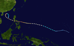
Tropical Storm Nina, which began its life on November 16 in the eastern portion of the Western Pacific Ocean, slowly strengthened to a typhoon on the 21st. It continued to strengthen as it passed through the Caroline Islands, and reached super typhoon strength on the 25th just east of the Philippines. Nina continued to intensify, and reached a peak of 165 mph (266 km/h) winds just before hitting the central Philippines on the evening of the 25th. Nina exited the archipelago the next day as a 105 mph (169 km/h) typhoon. Nina briefly re-strengthened to a 115 mph (185 km/h) typhoon before turning to the north. The typhoon briefly threatened Hong Kong on the 28th, but vertical shear caused the low level circulation and upper-level circulation to separate, leaving a rapidly weakening Nina to turn southward over the South China Sea. The storm finally dissipated on the 30th, but not after causing 1,036 casualties and extensive crop damage on its path of 1.12 billion Philippine Pesos (1987 pesos). [11]

Tropical Depression Ogden

Tropical depression (JMA)
Tropical storm (SSHWS)
Ogden Nov 25 1987 0036Z.png   Ogden 1987 track.png
DurationNovember 23 – November 25
Peak intensity85 km/h (50 mph) (1-min);
1002  hPa  (mbar)

Ogden hit Philippines and later dissipated in Vietnam.

Typhoon Phyllis (Trining)

Typhoon (JMA)
Category 3 typhoon (SSHWS)
Phyllis Dec 15 1987 2339Z.png   Phyllis 1987 track.png
DurationDecember 9 – December 20
Peak intensity140 km/h (85 mph) (10-min);
960  hPa  (mbar)

Affecting the Philippines three weeks after Typhoon Nina devastated the archipelago, Typhoon Phyllis prompted typhoon alerts for the Visayans. [12] Offshore northern Samar Island, a ferry boat carrying 50 people sank, though 27 were rescued, the bodies of 10 drowning victims were recovered and 13 others were feared dead. [12]

Storm names

During the season 23 named tropical cyclones developed in the Western Pacific and were named by the Joint Typhoon Warning Center, when it was determined that they had become tropical storms. These names were contributed to a revised list from 1979.

OrchidPercyRuthSperryThelmaVernonWynneAlexBettyCaryDinahEd
FredaGeraldHollyIanJuneKellyLynnMauryNinaOgdenPhyllis

Philippines

AuringBebengKatringDidingEtang
GeningHermingIsingLudingMameng
NenengOniangPepangRosingSisang
TriningUring (unused)Warling (unused)Yayang (unused)
Auxiliary list
Ading (unused)
Barang (unused)Krising (unused)Dadang (unused)Erling (unused)Goying (unused)

The Philippine Atmospheric, Geophysical and Astronomical Services Administration uses its own naming scheme for tropical cyclones in their area of responsibility. PAGASA assigns names to tropical depressions that form within their area of responsibility and any tropical cyclone that might move into their area of responsibility. Should the list of names for a given year prove to be insufficient, names are taken from an auxiliary list, the first 6 of which are published each year before the season starts. Names not retired from this list will be used again in the 1991 season. This is the same list used for the 1983 season. PAGASA uses its own naming scheme that starts in the Filipino alphabet, with names of Filipino female names ending with "ng" (A, B, K, D, etc.). Names that were not assigned/going to use are marked in gray.

Retirement

Owing to their extensive damage and death toll within the Philippines, the PAGASA later retired the names Herming and Sisang. Replaced names were selected as Helming and Sendang for the 1991 season. The name Katring, which replaced Karing in 1983 for still unknown reasons, was removed from this list (List I). It was previously included in another list (List IV) as an auxiliary name, replacing Kading which was retired after the 1978 season. Because of this, the name Karing was reinstated in this list for the 1991 season.

Season effects

This is a table of all of the storms that have formed in the 1987 Pacific typhoon season. It includes their duration, names, affected areas, damages, and death totals. Deaths in parentheses are additional and indirect (an example of an indirect death would be a traffic accident), but were still related to that storm. Damage and deaths include totals while the storm was extratropical, a wave, or a low, and all of the damage figures are in 1986 USD. Names listed in parentheses were assigned by PAGASA.

NameDatesPeak intensityAreas affectedDamage
(USD)
DeathsRefs
Category Wind speedPressure
Orchid (Auring)January 7–14Typhoon165 km/h (103 mph)955 hPa (28.20 inHg)Caroline IslandsNoneNone
PercyApril 6–16Tropical storm85 km/h (53 mph)1,000 hPa (29.53 inHg)Caroline Islands NoneNone
RuthJune 17–20Tropical storm85 km/h (53 mph)992 hPa (29.29 inHg)South China NoneNone
TDJune 17–18Tropical depressionNot specified1,004 hPa (29.65 inHg)Taiwan, Ryukyu IslandsNoneNone
Sperry (Bebeng)June 26 – July 1Typhoon120 km/h (75 mph)980 hPa (28.94 inHg)Caroline IslandsNoneNone
Thelma (Katring)July 7–16Typhoon185 km/h (115 mph)915 hPa (27.02 inHg)Marshall Islands, Philippines, Taiwan, Japan, Korean Peninsula$272 million138
Vernon (Diding)July 16–22Severe tropical storm110 km/h (68 mph)985 hPa (29/09 inHg)Philippines, TaiwanNoneNone
Wynne (Gening)July 21 – August 1Typhoon185 km/h (115 mph)920 hPa (27.17 inHg)Marshall Islands, Mariana Islands, JapanNoneNone
Alex (Etang)July 21–29Typhoon120 km/h (75 mph)970 hPa (28.64 inHg)Philippines, TaiwanNoneNone
TDAugust 5–6Tropical depressionNot specified1,004 hPa (29.65 inHg)NoneNoneNone
TDAugust 5–6Tropical depressionNot specified1,006 hPa (29.71 inHg)NoneNoneNone
Betty (Herming)August 8–17Typhoon205 km/h (127 mph)890 hPa (26.28 inHg)Philippines, Vietnam, Thailand$100 million92
TenAugust 10–13Tropical storm65 km/h (40 mph)1,006 hPa (29.71 inHg)Japan NoneNone
Cary (Ising)August 12–17Typhoon140 km/h (87 mph)960 hPa (28.35 inHg)Philippines, Vietnam, South China$5.58 million25
TDAugust 13–14Tropical depressionNot specified1,006 hPa (29.71 inHg)NoneNoneNone
TDAugust 18–21Tropical depressionNot specified1,008 hPa (29.77 inHg)NoneNoneNone
Dinah (Luding)August 20–31Typhoon185 km/h (115 mph)915 hPa (27.02 inHg)Caroline Islands, Japan, South Korea$679 million40
EdAugust 21–29Tropical depression65 km/h (40 mph)1,006 hPa (29.71 inHg)Caroline IslandsNoneNone
Gerald (Neneng)September 3–10Typhoon150 km/h (93 mph)950 hPa (28.05 inHg)Philippines, Taiwan, China$135 million127
MamengSeptember 3–5Tropical depression45 km/h (28 mph)1,002 hPa (29.59 inHg)VietnamNoneNone
FredaSeptember 4–18Typhoon195 km/h (121 mph)915 hPa (27.02 inHg)Caroline Islands, Mariana IslandsNoneNone
HollySeptember 5–17Typhoon205 km/h (127 mph)900 hPa (26.58 inHg)Marshall IslandsNoneNone
IanSeptember 23 – October 4Typhoon140 km/h (87 mph)955 hPa (28.20 inHg)Mariana IslandsNoneNone
17WSeptember 25–26Tropical depression55 km/h (34 mph)1,006 hPa (29.71 inHg)NoneNoneNone
PekeSeptember 28 – October 6Typhoon150 km/h (93 mph)950 hPa (28.05 inHg)NoneNoneNone
JuneSeptember 28 – October 2Tropical storm85 km/h (53 mph)992 hPa (29.29 inHg)None NoneNone
Kelly (Oniang)October 9–17Typhoon140 km/h (87 mph)955 hPa (28.20 inHg)JapanNone8
Lynn (Pepang)October 15–28Typhoon195 km/h (121 mph)920 hPa (27.17 inHg)Mariana Islands, Philippines, Taiwan, South China$32.3 million49
Maury (Rosing)November 13–19Tropical storm85 km/h (53 mph)994 hPa (29.35 inHg)Philippines, Vietnam NoneNone
Nina (Sisang)November 19–30Typhoon165 km/h (103 mph)930 hPa (27.46 inHg)Caroline Islands, Philippines, South China$84.5 million912
OgdenNovember 23–25Tropical depression85 km/h (53 mph)1,002 hPa (29.59 inHg)VietnamNoneNone
Phyllis (Trining)December 11–20Typhoon140 km/h (87 mph)960 hPa (28.35 inHg)Caroline Islands, PhilippinesNone13
Season aggregates
32 systemsJanuary 7 – December 20, 1987205 km/h (127 mph)890 hPa (26.28 inHg)>$1.31 billion1,404

See also

Related Research Articles

<span class="mw-page-title-main">2005 Pacific typhoon season</span> Typhoon season in the Western Pacific Ocean

The 2005 Pacific typhoon season was the least active typhoon season since 2000, producing 23 named storms, of which 13 became typhoons. It was an event in the annual cycle of tropical cyclone formation, in which tropical cyclones form in the western Pacific Ocean. The season ran throughout 2005, though most tropical cyclones typically develop between May and October. The season's first named storm, Kulap, developed on January 13, while the season's last named storm, Bolaven, dissipated on November 20. The season's first typhoon, Haitang, reached typhoon status on July 13, and became the first super typhoon of the year three days later.

<span class="mw-page-title-main">2004 Pacific typhoon season</span> Typhoon season in the Western Pacific Ocean

The 2004 Pacific typhoon season was an extremely active season that featured the second-highest ACE ever recorded in a single season, second only to 1997, which featured 29 named storms, nineteen typhoons, and six super typhoons. It was an event in the annual cycle of tropical cyclone formation, in which tropical cyclones form in the western Pacific Ocean. The season ran throughout 2004, though most tropical cyclones typically develop between May and October. The season's first named storm and also the first typhoon, Sudal, developed on April 4, later was reached typhoon status two days later, and became the first super typhoon of the year three days later. The season's last named storm, Noru, dissipated on December 21.

<span class="mw-page-title-main">2003 Pacific typhoon season</span> Typhoon season in the Western Pacific Ocean

The 2003 Pacific typhoon season was a slightly below average yearlong period of tropical cyclogenesis exhibiting the development of 45 tropical depressions, of which 21 became named storms; of those, 14 became typhoons. Though every month with the exception of February and March featured tropical activity, most storms developed from May through October. During the season, tropical cyclones affected the Philippines, Japan, China, the Korean Peninsula, Indochina, and various islands in the western Pacific.

<span class="mw-page-title-main">2002 Pacific typhoon season</span> Typhoon season in the Western Pacific Ocean

The 2002 Pacific typhoon season was a slightly above average Pacific typhoon season, producing twenty-six named storms, fifteen becoming typhoons, and eight super typhoons. It had an ACE over 400 units, making it one of the most active seasons worldwide. It was an event in the annual cycle of tropical cyclone formation, in which tropical cyclones form in the western Pacific Ocean. The season ran throughout 2002, though most tropical cyclones typically develop between May and October. The season's first named storm, Tapah, developed on January 11, while the season's last named storm, Pongsona, dissipated on December 11. The season's first typhoon, Mitag, reached typhoon status on March 1, and became the first super typhoon of the year four days later.

<span class="mw-page-title-main">2001 Pacific typhoon season</span> Typhoon season in the Western Pacific Ocean

The 2001 Pacific typhoon season was the fourth and final consecutive year with below-average activity, making it the lowest four-year period of activity since 1976–1979, due to the presence of a strong La Niña that had persisted from 1998 to 2001. However, it was more active than the previous seasons, producing twenty-five named storms, sixteen typhoons and three super typhoons, with a near normal Accumulated Cyclone Energy (ACE) of 307.3 units. It ran year-round in 2001, with most tropical cyclones in the northwestern Pacific Ocean tending between May and November.

<span class="mw-page-title-main">1988 Pacific typhoon season</span> Typhoon season in the Pacific Ocean

The 1988 Pacific typhoon season was a very active season, though it only featured 1 super typhoon. It had no official bounds; it ran year-round in 1988, but most tropical cyclones formed between May and November. Tropical storms that formed in the entire west Pacific basin were assigned a name by the Joint Typhoon Warning Center. Tropical depressions that enter or form in the Philippine area of responsibility are assigned a name by the Philippine Atmospheric, Geophysical and Astronomical Services Administration or PAGASA. This can often result in the same storm having two names.

<span class="mw-page-title-main">Typhoon Angela (1989)</span> Pacific typhoon in 1989

Typhoon Angela, known in the Philippines as Typhoon Rubing, was an intense tropical cyclone that formed in late September 1989. The storm developed from a tropical disturbance in the monsoon trough and moved generally westward throughout its duration. The storm ultimately peaked in intensity as a super typhoon and struck northern Luzon in the Philippines. After weakening and traversing the South China Sea, Angela bypassed Hainan to the south and struck Vietnam before dissipating. The storm caused severe damage and 119 fatalities in the Philippines. Thousands of houses were damaged, and hundreds of thousands of residents were impacted by the typhoon. Monetary damage is placed at $8 million.

<span class="mw-page-title-main">Typhoon Alex (1987)</span> Pacific typhoon in 1987

Typhoon Alex, known in the Philippines as Typhoon Etang, affected the Taiwan, China, and South Korea during July 1987. Typhoon Alex developed from the monsoon trough that spawned a tropical disturbance late on July 21 southwest of Guam which organized into a tropical depression shortly thereafter. The system steadily became better organized, and the next day, a tropical depression had developed. Satellite intensity estimates gradually increased, and on July 23, the depression intensified into Tropical Storm Alex. After initially tracking west-northwest, Tropical Storm Alex started tracking northwest. An eye developed on July 24, and on the next day, Alex was classified as a typhoon, when Alex attained its peak intensity of 120 km/h (75 mph) and a minimum barometric pressure of 970 mbar (29 inHg). Alex weakened while tracking more northward, though interaction with Taiwan resulted in a more westward track starting on July 27. The storm struck near Shanghai as a tropical storm, and weakened over land, although it remained identifiable through August 2.

<span class="mw-page-title-main">Typhoon Cecil (1985)</span> Pacific typhoon in 1985

Typhoon Cecil, known in the Philippines as Tropical Storm Rubing, was one of two typhoons to strike Vietnam within a week in 1985. Cecil originated from an area of convection that tracked west-northwest and passed south of Palau late on October 9. The disturbance became increasingly defined as it moved through the southern Philippines. On October 12, a tropical depression developed, and the next day, the depression was upgraded into a tropical storm. Cecil turned northwest over the open waters of the South China Sea as it steadily strengthened, and was classified as a typhoon on October 14. After unexpectedly slowing down, Cecil continued to intensify and at noon of October 14, reached its peak intensity of 145 km/h (90 mph). Land interaction with Vietnam triggered a weakening trend. After turning west, Cecil moved onshore just north of Huế at 22:00 UTC on October 15. After tracking into Laos, the typhoon dissipated 39 hours later.

<span class="mw-page-title-main">Timeline of the 2014 Pacific typhoon season</span>

This timeline documents all of the events of the 2014 Pacific typhoon season. Most of the tropical cyclones forming between May and November. The scope of this article is limited to the Pacific Ocean, north of the equator between 100°E and the International Date Line. Tropical storms that form in the entire Western Pacific basin are assigned a name by the Japan Meteorological Agency. Tropical depressions that form in this basin are given a number with a "W" suffix by the United States' Joint Typhoon Warning Center. In addition, the Philippine Atmospheric, Geophysical and Astronomical Services Administration (PAGASA) assigns names to tropical cyclones that enter or form in the Philippine area of responsibility. These names, however, are not in common use outside of the Philippines.

<span class="mw-page-title-main">Typhoon Faye (1982)</span> Pacific typhoon in 1982

Typhoon Faye also known in the Philippines as Typhoon Norming was a long-lived typhoon that struck the Philippines in August 1982. On August 16, a weak tropical disturbance was moving towards the southern Philippines. Initially, land interaction with the Philippines with prevented significant development. After crossing the Philippines, the disturbance emerged into the South China Sea and increased in organization. It was upgraded into a tropical storm by midday on August 22. Thereafter, Faye began to steadily strengthen, and attained typhoon intensity later that day. On August 23, Typhoon Faye reached its peak intensity, which the storm would maintain for approximately 12 hours. A small cyclone, Faye moved northward on August 24 due to the weakening of a ridge over China. Thereafter, its center was disrupted by land interaction with the Philippines. As such, the storm weakened slightly before striking Luzon on the morning of August 25. Severe flooding and strong winds were recorded. More than 5,000 houses were damaged while 220,000 were homeless. Furthermore, around 7,000 people sought shelter. There were 18 injuries and 41 deaths in the Philippines. Overall, damage amounted to $9.6 million (1982 USD). Across Japan, two people perished.

<span class="mw-page-title-main">Tropical Storm Tess</span> Pacific severe tropical storm in 1988

Severe Tropical Storm Tess known in the Philippines as Tropical Storm Welpring was the second of three tropical cyclones to directly impact the Philippines in a two-week time frame in 1988. An area of disturbed weather near the Philippines was first observed on November 1. Following an increase in organization, the disturbance was designated as a tropical cyclone on November 4. Moving west, Tess steadily strengthened due to favorable conditions aloft. During the evening of November 5, Tess was estimated to have achieved its highest intensity, with winds of 115 km/h (70 mph). Rapid weakening then ensured as Tess neared Vietnam, and after making landfall in the country on November 6, Tess dissipated the next day.

<span class="mw-page-title-main">Typhoon Lingling (2001)</span> Pacific typhoon in 2001

Typhoon Lingling, known in the Philippines as Typhoon Nanang, was a deadly typhoon that struck the Philippines and Vietnam in 2001 and caused 379 deaths. The name "Lingling" was given by Hong Kong. The 39th tropical depression, 22nd named storm, and 13th typhoon of the 2001 Pacific typhoon season, Lingling developed into a tropical depression on November 6 and given the local name Nanang by the PAGASA. The next day, it was upgraded into a tropical storm and given the name Lingling by the Japan Meteorological Agency (JMA). Lingling's intensity briefly stagnated as it moved over Visayas before resuming intensification and intensifying into a severe tropical storm on November 8. One day later, both the JMA and the Joint Typhoon Warning Center (JTWC) upgraded Lingling to a typhoon as it exited the Philippine archipelago and moved into the South China Sea. After intensifying into a typhoon, Lingling began to quickly intensify, peaking with 10-min sustained winds of 155 km/h (96 mph) and 1-min sustained winds of 215 km/h (134 mph), with a minimum central pressure of 940 mbar (28 inHg). Lingling began to weaken as it approached the Vietnamese coast, before making landfall on November 11 at 18:00 UTC. Lingling rapidly weakened afterward, dissipating on November 12.

<span class="mw-page-title-main">Typhoon Gerald</span> Pacific typhoon in 1987

Typhoon Gerald, known in the Philippines as Typhoon Neneng, affected the Philippines, Taiwan, and China during September 1987. A tropical depression developed on September 4, and within 24 hours, intensified into a tropical storm. After initially moving erratically within the Philippine Sea, Gerald moved west-northwest and then northwest while steadily deepening. Gerald obtained typhoon intensity on September 8, and the following day, attained maximum intensity. Shortly thereafter, the typhoon skirted southwestern Taiwan, which resulted in a steady weakening trend. On September 10, Gerald moved ashore north of Hong Kong near Amoy. Gerald dissipated the next day.

<span class="mw-page-title-main">Typhoon Abby (1986)</span> Pacific typhoon in 1986

Typhoon Abby, known as Typhoon Norming in the Philippines, was the second typhoon to affect Taiwan in a month during September 1986. A tropical depression developed on September 13 and the next day attained tropical storm status, upon which it was named Abby. Continuing to intensify, Abby moved west-northwest and became a typhoon on September 16. Two days later, the typhoon attained maximum intensity. On September 19, the typhoon made landfall in Taiwan as it turned towards the northwest. Rapid weakening occurred due to land interaction, and on September 20, Typhoon Abby transitioned into an extratropical cyclone. Its extratropical remnants were last noted on September 24 as they raced off to the northeast.

<span class="mw-page-title-main">Typhoon Joe</span> Pacific typhoon in 1980

Typhoon Joe, known in the Philippines as Typhoon Nitang, affected the Philippines, China, and Vietnam during July 1980. An area of disturbed weather formed near the Caroline Islands on July 14. Shower activity gradually became better organized, and two days later, the system was upgraded into a tropical depression. On July 18, the depression was classified as Tropical Storm Joe. Initially, Joe moved northwest, but began to turn to the west-northwest, anchored by a subtropical ridge to its north. Joe started to deepen at a faster clip, and attained typhoon intensity on July 19. The eye began to clear out, and the next day, Joe reached its highest intensity. Shortly thereafter, Joe moved ashore the Philippines. There, 31 people were killed and 300,000 others were directly affected. Around 5,000 homes were destroyed, resulting in an additional 29,000 homeless. Damage in the nation was estimated at $14.5 million (1980 USD).

<span class="mw-page-title-main">Typhoon Betty (1980)</span> Pacific typhoon in 1980

Typhoon Betty, known in the Philippines as Typhoon Aring, was the strongest typhoon to strike the Philippines in ten years. An area of disturbed weather developed on October 27, 1980, near Truk Atoll. After turning east from south, the disturbance was classified as a tropical storm on October 29 as it passed near Guam, causing only minor damage. Following a turn to the west-northwest, Betty attained typhoon intensity the next day. On November 4, Betty peaked in intensity. Later that day, Betty moved ashore over Luzon, introducing a rapid weakening trend. Over land, Betty then began to turn north due to a weakening subtropical ridge to its north and a trough offshore Taiwan. By November 8, Betty, after moving offshore, had completed its transition into an extratropical cyclone, and dissipated that same day.

<span class="mw-page-title-main">Typhoon Irving (1982)</span> Pacific typhoon in 1982

Typhoon Irving, known in the Philippines as Tropical Storm Ruping, was a mid-season tropical cyclone that affected the Philippines and China during September 1982. An area of disturbed weather developed within the monsoon trough during early September 1982 near Guam. Following an increase in organization, a tropical depression developed on the morning of September 5. Later that day, the depression intensified into Tropical Storm Irving. Irving tracked westward, nearly becoming a typhoon before hitting the central Philippines. There, Irving uprooted trees, downed power and telephone lines, triggered landslides, and forced the cancellation of several domestic airline flights. Irving damaged 7,890 houses in Albay and Sorsogon provinces alone, resulting in 138,500 people homeless. Nation-wide, 65 people were killed, 26 others were hurt, and 29 were rendered missing. A total of 44,383 families or 248,040 residents sought shelter. Moreover, 18,488 homes were damaged and 5,599 others were demolished. Damage in the country was assessed at US$23.3 million, including US$14.2 million in crops. While crossing the island chain, Irving turned northwestward. After entering the South China Sea, Irving continued generally northwest, and became a typhoon on September 11. After developing a well-defined eye, Irving attained its peak intensity of 160 km/h (100 mph) the following day. Land interaction with Hainan Island resulted in a weakening trend, and Irving was downgraded to a tropical storm before striking the southern coast of China on September 15. Across the Leizhou Peninsula, 90% of homes were damaged. Onshore, Irving rapidly weakened and the storm dissipated on September 16.

<span class="mw-page-title-main">Tropical Storm Durian (2001)</span> Pacific severe tropical storm in 2001

Severe Tropical Storm Durian was a deadly system that caused severe impacts in China and Vietnam. The seventh tropical depression and third named storm of the 2001 Pacific typhoon season, the storm was first noted on June 29 and quickly intensified into a tropical storm and given the name Durian by the Japan Meteorological Agency (JMA). Durian continued northwestward before intensifying into a severe tropical storm as it approached the Chinese coast. On July 1 just before landfall, Durian peaked in intensity, with the JMA estimating 10-min winds of 110 km/h (68 mph) and the Joint Typhoon Warning Center (JTWC) estimating 1-min winds of 140 km/h (87 mph). Durian made landfall on Zhanjiang at peak intensity, before quickly weakening over land and dissipating on July 3 over the mountains of Vietnam.

<span class="mw-page-title-main">Typhoon Lola (1993)</span> Pacific typhoon in 1993

Typhoon Lola, known in the Philippines as Typhoon Monang, was a deadly typhoon that impacted the Philippines and Indochina. The 47th tropical depression, 26th named storm, and 14th typhoon of the 1993 Pacific typhoon season, the origins of Lola can be traced back to an active near-equatorial trough. The JTWC began monitoring an area of convection on November 27, and on December 1, it developed into a tropical depression. The JMA upgraded the depression to a tropical storm the next day, with the JTWC giving it the name Lola on December 3. 12 hours later, the JMA upgraded Lola to a severe tropical storm. On December 4 at 6:00 UTC, the JTWC upgraded Lola to a typhoon. Shortly after, Lola reached its initial peak intensity, with the JMA assessing that it had peaked with a minimum central pressure of 955 hPa; Lola made landfall near the municipality of Vinzons on December 5 at 12:00 UTC. After making landfall, Lola weakened to a tropical storm as it emerged over the South China Sea on December 6, before re-strengthening into a typhoon. After strengthening into a typhoon, Lola began to quickly intensify, reaching its peak intensity with 1-min winds of 195 km/h (120 mph) on December 8 at 12:00 UTC. Lola weakened slightly before making its final landfall near the city of Camh Ranh as a Category 2-equivalent storm. Lola quickly weakened over land, dissipating on December 9.

References

  1. Gary Padgett. May 2003 Tropical Cyclone Summary. Archived 2010-11-30 at the Wayback Machine Retrieved 2006-08-26.
  2. 1 2 3 4 5 6 7 8 "JTWC Report for Typhoon Orchid" (PDF). Joint Typhoon Warning Center . Retrieved 2009-08-19.
  3. Staff Writer (July 29, 2008). "US Pacific Storm and Flooding Disaster Declarations". FEMA. Archived from the original on 2010-12-24. Retrieved December 6, 2009.
  4. 1 2 3 4 5 6 7 8 9 10 11 12 13 14 15 16 17 18 19 20 21 22 23 24 25 26 27 28 29 30 31 32 33 34 35 36 37 38 39 40 41 42 43 44 45 46 47 48 49 50 51 52 53 54 55 56 57 58 59 60 61 62 63 64 65 66 67 68 69 70 71 72 73 74 75 76 77 78 79 Joint Typhoon Warning Center; Naval Pacific Meteorology and Oceanography Center (1988). Annual Tropical Cyclone Report: 1987 (PDF) (Report). United States Navy, United States Air Force. Archived from the original (PDF) on February 21, 2013. Retrieved July 5, 2017.
  5. 1 2 3 4 5 6 7 8 9 10 11 12 13 14 15 16 17 18 19 20 21 22 23 24 25 26 27 28 29 30 31 32 33 34 35 36 37 38 39 40 41 42 43 44 45 46 47 48 49 50 51 52 53 54 55 56 57 58 Japan Meteorological Agency (October 10, 1992). RSMC Best Track Data – 1980–1989 (Report). Archived from the original (.TXT) on December 5, 2014. Retrieved July 5, 2017.
  6. 1 2 Hong Kong Observatory (1988). "Part III – Tropical Cyclone Summaries". Meteorological Results: 1987 (PDF). Meteorological Results (Report). Hong Kong Observatory. Archived from the original (PDF) on October 23, 2019. Retrieved July 6, 2017.
  7. 1 2 Hughes, David (July 31, 1987). "Typhoon Wynne skirts Saipan" (PDF). Marianas Variety. pp. 1, 5. Retrieved July 7, 2017.
  8. Joint Typhoon Warning Center. Typhoon Gerald. Archived 2011-06-07 at the Wayback Machine Retrieved on 2007-01-19.
  9. Joint Typhoon Warning Center. Typhoon Kelly. Archived 2011-06-07 at the Wayback Machine Retrieved on 2007-01-19.
  10. Joint Typhoon Warning Center. Super Typhoon Lynn. Archived 2011-06-07 at the Wayback Machine Retrieved on 2007-01-19.
  11. Philippine Atmospheric Geophysical and Astronomic Services Administration. Most Destructive Tropical Cyclones for Month of November (1948–2000). Archived 2006-09-25 at the Wayback Machine Retrieved on 2007-02-04.
  12. 1 2 "Typhoon batters Philippines". United Press International. December 16, 1987.