1951 Pacific typhoon season

Last updated
1951 Pacific typhoon season
1951 Pacific typhoon season summary map.png
Season summary map
Seasonal boundaries
First system formedFebruary 19, 1951
Last system dissipatedDecember 16, 1951
Strongest storm
Name Marge
  Maximum winds185 km/h (115 mph)
(1-minute sustained)
  Lowest pressure886 hPa (mbar)
Seasonal statistics
Total depressions31
Total storms25
Typhoons16
Super typhoons1 (unofficial)
Total fatalities1,185 total
(including missing and injured)
Total damage$106.15 million (1951 USD)
Related articles
Pacific typhoon seasons
1949, 1950, 1951, 1952, 1953

The 1951 Pacific typhoon season was a generally below average season with multiple tropical cyclones striking the Philippines. With the exception of January, each month saw at least one tropical system develop; October was the most active month with four tropical cyclones forming. Overall, there were 21 tropical depressions, of which 17 became named storms; of those, there were 16 typhoons.

Contents

The season began with the formation of a short-lived unnamed tropical storm on February 19, well east of the Philippines; Typhoon Georgia became the season's first named storm and typhoon after first developing in the open Pacific on March 20. In April, Typhoon Iris developed before intensifying into a super typhoon the following month; Iris was the first recorded instance of a Category 5-equivalent typhoon in the western Pacific. The final typhoon and storm of the year was Typhoon Babs, which remained at sea before dissipating on December 17.

The scope of this article is limited to the Pacific Ocean, north of the equator and west of the International Date Line. Storms that form east of the date line and north of the equator are called hurricanes; see 1951 Pacific hurricane season. At the time, tropical storms that formed within this region of the western Pacific were named and identified by the Fleet Weather Center in Guam. However, the Japan Meteorological Agency  (JMA), which was established five years later, identified four additional tropical cyclones during the season not tracked by the Fleet Weather Center; these analyzed systems did not receive names.

Systems

Typhoon Amy (1951)Typhoon Ruth (1951)Typhoon Marge (1951)Saffir–Simpson hurricane wind scale1951 Pacific typhoon season

Typhoon Georgia

Typhoon (JMA)
Category 4 typhoon (SSHWS)
Typhoon Georgia analysis 22 Mar 1951.png   Georgia 1951 track.png
DurationMarch 18 – March 27
Peak intensity220 km/h (140 mph) (1-min) 970  hPa  (mbar)

A persistent low-pressure area south of Kusaie was first noted on March 14. The origins of the cyclonic circulation remain disputed, with one hypothesis indicating initial development south of Nauru and another suggesting that the system originated from a minor tropical wave east of the Marshall Islands. Nonetheless, southeasterly flow associated with an unusually strong high pressure area positioned over northeastern Australia aided the tropical cyclogenesis of the disturbance, [1] and at 1200  UTC on March 18, the circulation developed into a tropical depression. In its initial stages, the disturbance steadily intensified as it moved in a northeasterly direction, attaining tropical storm strength by 1800 UTC the next day. At 0600 UTC on March 20, Georgia reached typhoon intensity; [2] however, the Guam Fleet Warning Center only issued its first typhoon bulletin on the tropical cyclone at 0600 UTC the following day, [1] by which time Georgia already had winds of 185 km/h (115 mph), equivalent to a Category 3 hurricane on the Saffir–Simpson hurricane wind scale. [2] At the same time, the typhoon began to develop an eye. [1] Subsequently, Georgia attained its peak intensity with maximum sustained winds of 220 km/h (140 mph), equivalent to a modern-day Category 4 hurricane. Afterwards, the intense typhoon began to quickly lose organization and strength, [1] and degenerated into a remnant low after 0600 UTC on March 25, [2] coinciding with the last typhoon bulletin issued by the Guam Fleet Warning Center. [1] The remnants tracked westward before dissipating after 0600 UTC on March 28. [3]

As a developing tropical system, the precursor to Georgia and resultant tropical depression moved near Kusaie, producing a peak rainfall total of 137 mm (5.4 in) over a three-day period and gusts in excess of 95 km/h (59 mph). On March 20, Georgia passed to the south of Kwajalein. As such, the island's station observed "strong surface winds" and 236 mm (9.3 in) of rain in an eighteen-hour period. [1] As a weakening tropical cyclone, Georgia threatened Wake Island and Eniwetok Atoll; the latter of which was expected to be the site of American nuclear testing operations. [4] Though both islands were warned of by the Guam Fleet Weather Center, however, the typhoon had weakened considerably before reaching them, and effects remained marginal. Nonetheless, 52 mm (2.0 in) of rain was reported on a weather station in Eniwetok. [1] The nuclear testing operation, termed Operation George, remained unaffected, [5] though the first test was detonated on July 4, well after Georgia dissipated. [6]

Typhoon Hope

Typhoon (JMA)
Category 1 typhoon (SSHWS)
Typhoon Hope analysis 18 Apr 1951.png   Hope 1951 track.png
DurationApril 15 – April 23
Peak intensity130 km/h (80 mph) (1-min) 980  hPa  (mbar)

In early April, several cyclonic vortices were noted south of the Marshall Islands. One of these circulation centers tracked westward and later developed into a tropical depression near Micronesia early on April 15. [7] [8] Steadily intensifying, the disturbance intensified into a tropical storm by 1800 UTC the next day. At roughly the same time, Hope began to curve slightly to the north. The Guam Fleet Warning Center estimated that the tropical storm intensified into a typhoon by 1800 UTC on April 17, before strengthening further to reach its peak intensity with maximum sustained winds of 130 km/h (81 mph) at 0000 UTC. [8] At the same time, the weather center at Andersen Air Force Base in Guam began issuing bulletins on the storm. Shortly after, Hope executed a small anticyclonic loop, which resulted in the tropical cyclone tracking westward. After this loop was completed, however, the typhoon began to weaken. [7] This weakening trend continued, and the Guam Fleet Warning Center ceased the issuance of bulletins at 1200 UTC on April 20, by which time Hope was deemed too weak to be classified as a tropical cyclone. However, the China Meteorological Agency  (CMA), in analysis of the system, determined that Hope had persisted up until late on April 23 before dissipating. [8]

Typhoon Iris

Typhoon (JMA)
Category 5 super typhoon (SSHWS)
Typhoon Iris analaysis 4 May 1951.png   Iris 1951 track.png
DurationApril 28 – May 11
Peak intensity280 km/h (175 mph) (1-min) 909  hPa  (mbar)

In late April, a well-developed tropical wave began developing east of Chuuk Lagoon. [9] Tracking westward, the easterly wave was analyzed to have organized into a tropical depression by 0000 UTC on April 29. [10] Twelve hours later, Iris was estimated to have strengthened into a tropical storm. [11] At roughly the same time, a vessel in the vicinity of the storm reported winds in excess of 65 km/h (40 mph), prompting the Guam Fleet Weather Center to initiate reconnaissance flights into the cyclone. [7] Midday on April 30, Iris intensified into the equivalent of a modern-day typhoon as it moved in a slightly oscillatory path towards the Philippines. [7] [11] After a slight fluctuation in intensity during the overnight hours of May 1, Iris rapidly intensified to reach its peak intensity with a minimum pressure of 909 mbar (909 hPa; 26.8 inHg) and maximum sustained winds of 280 km/h (170 mph) early on May 4, [11] making it the equivalent of a Category 5 super typhoon; [10] at the time this was the first confirmed instance of a typhoon reaching such intensities. [2] Afterwards, Iris weakened slightly before making landfall on South Luzon around 1800 UTC the following day. [11]

After passing and weakening through the Philippines, Iris emerged into the South China Sea on May 6 as a tropical storm. At the same time, it began to recurve towards the northeast. On May 9, Iris reached a secondary peak intensity south of the Ryukyu Islands with winds of 160 km/h (99 mph), before subsequently weakening. [11] Afterwards, the tropical cyclone underwent extratropical transition, though the timing of such an event is disputed between the JMA and the CMA, with the former indicating that such a transition occurred on May 11, [12] and the latter indicating a transition on May 14. [10] Nonetheless, Iris made an anticyclonic loop beginning on May 11, before accelerating northeastward and dissipating entirely on May 15. [11] Upon its dissipation, Iris set Guam Fleet Weather Center records for number of tropical cyclone bulletins issued, at 50, and number of reconnaissance fixes, at 54. [7] [11] At its landfall in the Philippines, the typhoon caused nine fatalities and injured an additional 39 people. [13] Rainfall peaked at 484.4 mm (19.07 in) in Gandara, Samar, with observed winds peaking at 155 km/h (96 mph) in nearby Catbalogan. Damage to highways, bridges, and crops was estimated at 19.2 million (US$9.5 million). [14]

Typhoon Joan

Category 1 typhoon (SSHWS)
Typhoon Joan analysis 8 May 1951.png   Joan 1951 track.png
DurationMay 3 – May 12
Peak intensity140 km/h (85 mph) (1-min) 980  hPa  (mbar)

A stationary trough of low pressure persisted near Nauru towards the end of April and into early May, producing heavy rains; a station on the island received 8.16 in (207 mm) in a 24-hour period from the system. An interaction between the trough and a passing tropical wave resulted in the formation of an organized disturbance on May 2 that tracked initially northwestward before taking a more westerly course. According to the JTWC, the system became sufficiently organized to be considered a tropical cyclone on May 3, [1] though the JMA indicates cyclogenesis three days later. [15] After some fluctuations in its strength in its nascent stages, Joan curved towards the northeast and strengthened into a typhoon on May 8, peaking that day with winds of 140 km/h (87 mph) and a minimum pressure of 980 mbar (980 hPa; 29 inHg). Concurrently, the typhoon stalled and traced out a clockwise loop for roughly a day before resuming a course towards the northwest. Gradual weakening ensued, and the system transitioned into an extratropical cyclone after May 12; the system would dissipate three days later. [1]

Typhoon Kate

Typhoon (JMA)
Category 3 typhoon (SSHWS)
Typhoon Kate analysis 1 Jul 1951.png   Kate 1951 track.png
DurationJune 26 – July 2
Peak intensity185 km/h (115 mph) (1-min) 975  hPa  (mbar)

A disturbance was first noted in the vicinity of Micronesia on June 17 approximately 400 km (250 mi) south of Guam. Aircraft traversing between Guam and the Philippines eventually confirmed the presence of a developing tropical depression by June 25, tracking towards the west. [7] By the following day, the system had strengthened into a tropical storm. The system curved towards the north by June 28 and had begun to trend towards the northeast thereafter, gradually strengthening to a typhoon by 18:00 UTC that day. The storm continued to accelerate towards the northeast, passing just east of the Ryukyu Islands on June 30 before reaching peak intensity offshore Kyushu with maximum sustained winds of 185 km/h (115 mph) and a central pressure estimated at 975 mbar (975 hPa; 28.8 inHg). Kate weakened slightly before making landfall the following day on Shikoku with winds of 170 km/h (110 mph). [16] The typhoon curved eastward and continued to weaken, tracking through Sagami Bay and emerging over the Pacific Ocean on July 2 as a tropical storm. [7] [16] Kate transitioned into an extratropical cyclone and would later dissipate the following day. [17]

Thirteen people died on Kyushu. Heavy rains flooded 2,000 houses and inundated 8,000 acres of farmland in Kagoshima and Miyazaki prefectures. [18]

Typhoon Louise

Category 4 typhoon (SSHWS)
Typhoon Louise analysis 29 Jul 1951.png   Louise 1951 track.png
DurationJuly 26 – August 2
Peak intensity220 km/h (140 mph) (1-min) 904  hPa  (mbar)

The westerly-tracking tropical wave that would develop into Typhoon Louise was closely monitored as it passed Guam on July 25. Strong winds and falling pressures documented in Ulithi strongly suggested that a tropical cyclone was developing in the vicinity. [7] The CMA analyzed the system promptly developing as a strong tropical storm early on July 25; [19] however, the JTWC would not begin issuing bulletins on Louise until reconnaissance aircraft confirmed the presence of an already stout typhoon the following day with winds of 145 km/h (90 mph). Tracking towards the west-northwest, the storm steadily strengthened, reaching its peak intensity on July 29 east of Luzon with winds peaking at 220 km/h (140 mph) and the central pressure bottoming out at 904 mbar (904 hPa; 26.7 inHg). Typhoon-strength winds began to rake the Filipino province of Isabela that day, ahead of Louise's eventual landfall on July 30 with winds of 185 km/h (115 mph). [7] The mountainous terrain weakened the storm significantly, [20] and Louise remained weakened system as it traversed the South China Sea before tracking over Wuchuan, Guangdong as a minimal tropical storm on August 2. The tropical cyclone degenerated into a remnant low inland the following day before dissipating entirely on August 5. [19]

Communications were cut in Cagayan on the northeastern portions of Luzon as strong winds felled antennas. [21] [22] In Tuguegarao, 300 homes were blown down by winds estimated at 145& km/h (90 mph), with similar destruction wrought to homes on the coastal city of Vigan. [20] The typhoon brought copious amounts of rainfall to Luzon, peaking at 483 mm (19.0 in) in a 24-hour period in Baguio; this total nearly set an all-time daily rainfall record for the city. [23] There were six fatalities and ten people were injured. [24] [25] Damage was estimated at ₱5.5 million (US$2.7 million). [26]

Typhoon Marge

Typhoon (JMA)
Category 3 typhoon (SSHWS)
Eye of Typhoon Marge, 1951.png   Marge 1951 track.png
DurationAugust 10 – August 24
Peak intensity185 km/h (115 mph) (1-min) 886  hPa  (mbar)

Typhoon Marge originated as a tropical storm southeast of Guam on August 10. Tracking towards the northwest, the strengthening system passed just south of the island the following day as a typhoon. On August 13, the storm began taking a more northwesterly path as it continued to intensify, reaching its peak intensity two days with maximum winds estimated at 185 km/h (115 mph) and a remarkably low pressure of 886 mbar (886 hPa; 26.2 inHg). Fluctuating in strength over the following days, Marge passed over the Amami Islands on August 18 before a more steadily weakening trend took hold as the typhoon moved into the East China Sea. The storm passed just offshore Shanghai before curving sharply towards the northeast into the Yellow Sea on August 21. Marge weakened to a tropical storm the next day after spending 11 continuous days as a typhoon. The cyclone made landfall near Boryeong, South Korea on August 23 and accelerated northeastwards across the Korean peninsula, transitioning into an extratropical cyclone over far-northeastern Manchuria before dissipating after August 24. [27]

Marge was the largest tropical cyclone ever observed to date, with a wind circulation extending 1,160 km (720 mi) in diameter; this record stood until it was eclipsed by Typhoon Tip in 1979. [28] Meteorologist Robert Simpson flew on board a reconnaissance mission that flew into Marge near its peak strength and documented the eye's visual and sampled characteristics. The flight was an atypical departure from normal reconnaissance missions due to secondary—albeit procedurally constrained—storm-research objectives. [29] Publishing his findings in the Bulletin of the American Meteorological Society in 1952, his work would be instrumental in the understanding of tropical cyclone structure. [30]

United Nations naval vessels and United States Navy armaments responding to the Korean War were evacuated from the western coast of the Korean peninsula in advance of the approaching typhoon. [31] [32] Gusts as high as 180 km/h (110 mph) were reported in Okinawa in what was considered the island's most impactful typhoon since U.S. military occupation in 1945. [33] Although damage was minimal to U.S. military installations, [34] crop damage was extensive in other parts of Okinawa and several roads and highways were washed out by the heavy rains and surf. Impacts were more extensive further north of Kyushu, where rainfall totals as high as 400 mm (16 in) produced widespread flooding that flooded rice paddies and over a thousand homes, prompting the evacuation of 11,943 people. Offshore, twelve fishing boats capsized in the rough surf, and storm surge killed four in the Kyushu village of Yoshikawa. [35] Across southern Japan, there were 12 deaths and 53 injuries caused by Marge. [36] In South Korea, the Busan area was particularly hard hit, with coastal flooding displacing 550 people from their destroyed wooden homes. A half-mile segment of railroad between Yeosu and Daejeon was also washed out. [37]

Typhoon Nora

Typhoon (JMA)
Category 3 typhoon (SSHWS)
Typhoon Nora analysis 2 Sep 1951.png   Nora 1951 track.png
DurationAugust 27 – September 4
Peak intensity185 km/h (115 mph) (1-min) 970  hPa  (mbar)

Nora produced "some damage" over a sparsely populated region of northern Luzon and caused communications outages. [38] In Hainan, 800 homes were destroyed along with 53 fishing boats. Two people were killed and fifteen were injured in Haikou. [39]

Typhoon Ora

Typhoon (JMA)
Category 2 typhoon (SSHWS)
Typhoon Ora analysis 18 Sep 1951.png   Ora 1951 track.png
DurationSeptember 11 – September 21
Peak intensity155 km/h (100 mph) (1-min) 980  hPa  (mbar)

Ora struck China

Typhoon Pat

Typhoon (JMA)
Category 2 typhoon (SSHWS)
Typhoon Pat analysis 25 Sep 1951.png   Pat 1951 track.png
DurationSeptember 20 – September 28
Peak intensity165 km/h (105 mph) (1-min) 980  hPa  (mbar)

Yap International Airport recorded 182.6 mm (7.19 in) of rain from Pat. [40]

Typhoon Ruth

Typhoon (JMA)
Category 4 typhoon (SSHWS)
Typhoon Ruth analysis 12 Oct 1951.png   Ruth 1951 track.png
DurationOctober 8 – October 15
Peak intensity220 km/h (140 mph) (1-min) 924  hPa  (mbar)

Storm warnings were issued for southern Japan on October 13. [41] Planes in Tokyo were grounded and courier service to Korea was suspended. [42] Ruth impacted Japan between October 13–15, killing 572 people and injuring another 2,644; 371 people were left unaccounted for. [43] Many of these deaths arose from river flooding triggered Ruth. [44] The storm damaged 221,118 homes and 9,596 ships, as well as some 3.5 million bushels of rice. [43] Due to Ruth's large size, much of the country was affected by the typhoon's winds and rains. A peak wind gust of 195 km/h (121 mph) and a rainfall total of 639.3 mm (25.17 in) was recorded Kamiyaku, Kagoshima; both of these values were the highest recorded in Japan from Ruth. [44] Yamaguchi Prefecture was most severely impacted by the typhoon. [43] [45] Coastal areas were inundated and communications were disrupted. [46] Winds reaching 150 km/h (93 mph) and waves 13.5 m (44 ft) high struck Sasebo, Nagasaki, sinking ships and damaging others in the harbor; among them were warships deployed for the Korean War. [47] American military installations throughout Japan incurred over US$1 million in damage. [48] Overall property damage in Japan was estimated at US$25 million, affecting an estimated 123,773 people; [49] total damage to property, crops, and forests reached US$55 million. [50]

Typhoon Sarah

Typhoon (JMA)
Category 3 typhoon (SSHWS)
Typhoon Sarah analysis 25 Oct 1951.png   Sarah 1951 track.png
DurationOctober 22 – October 27
Peak intensity185 km/h (115 mph) (1-min) 960  hPa  (mbar)

Typhoon Sarah remained in open waters.

Typhoon Thelma

Typhoon (JMA)
Category 4 typhoon (SSHWS)
Typhoon Thelma analysis 29 Oct 1951.png   Thelma 1951 track.png
DurationOctober 27 – November 1
Peak intensity230 km/h (145 mph) (1-min) 950  hPa  (mbar)

Thelma formed as a Tropical Storm on October 27 and strengthened to category 4 status with 145 mph winds. Thelma later curved away without affecting land at all before it dissipated on October 2. It did not affect land. It was one of the strongest of the season, however damage was minimal, and no deaths were reported. [51]

Tropical Storm Vera

Tropical storm (JMA)
Tropical storm (SSHWS)
Tropical Storm Vera analysis 31 Oct 1951.png   Vera 1951 track.png
DurationOctober 28 – November 1
Peak intensity110 km/h (70 mph) (1-min) 980  hPa  (mbar)

Vera remained at Tropical Storm status and did not affect land at all, thus being a minimal storm.

Typhoon Wanda

Typhoon (JMA)
Category 2 typhoon (SSHWS)
Typhoon Wanda analysis 20 Nov 1951.png   Wanda 1951 track.png
DurationNovember 16 – November 26
Peak intensity165 km/h (105 mph) (1-min) 985  hPa  (mbar)

On November 21, Typhoon Wanda moved across the Visayas and southern Luzon. The storm impacts fatally injured 82 people and displaced 213,242 others from their homes. [52]

Typhoon Amy

Typhoon (JMA)
Category 4 typhoon (SSHWS)
Typhoon Amy analysis 8 Dec 1951.png   Amy 1951 track.png
DurationDecember 3 – December 17
Peak intensity220 km/h (140 mph) (1-min) 950  hPa  (mbar)

On December 3, an area of low pressure first noted near the Kwajalein Atoll developed into a tropical cyclone. Tracking in a general westward direction, the storm quickly intensified to reach typhoon intensity the next day. However, the typhoon's asymmetricity resulted in a fluctuation of intensity over the following few days. [7] [53] Afterwards, Amy was able to intensify to reach its peak intensity with maximum sustained winds of 220 km/h (140 mph) and a minimum barometric pressure of 950 mbar (950 hPa; 28 inHg) on December 8. Over the ensuing two days, Amy moved over several islands in the central Philippines before emerging in the South China Sea on December 11 as the equivalent of a minimal typhoon. Shortly after, the tropical cyclone executed a tight anticyclonic loop while oscillating in strength several times before eventually weakening and dissipating on December 17, [7] [53] just east of Vietnam. [53]

In the Philippines, Amy was considered one of the worst typhoons to strike the island chain on record. [54] Making its initial landfall along with the concurrent eruption of Mount Hibok-Hibok on Camiguin, the typhoon disrupted volcanic relief operations and forced the displacement of victims already displaced by the volcano. [55] [56] Cebu City suffered the worst impacts of Amy – most of the city's buildings were heavily damaged, and 29 people died in the city. [57] [58] Strong winds and rainfall in the city associated with Amy also set records which still remain unbroken today. [59] Damage there was estimated at ₱560 million. [60] Along the east coast of Leyte, where Amy initially struck, ninety percent of homes were destroyed, [61] and a large swath of coconut plantations were wiped out. [62] In Panay, located on the western side of the Philippines, at least a thousand homes were destroyed in 41 towns. [63] Overall, Amy caused $30 million in damage, [64] [65] and at least 556 fatalities, [66] though the final death toll may have been as high as 991, making the typhoon one of the deadliest in modern Philippine history. [54] An additional 50,000 people were displaced by the storm. [64]

Typhoon Babs

Typhoon (JMA)
Category 3 typhoon (SSHWS)
Typhoon Babs analysis 15 Dec 1951.png   Babs 1951 track.png
DurationDecember 10 – December 16
Peak intensity185 km/h (115 mph) (1-min) 980  hPa  (mbar)

Typhoon Babs stayed at sea and caused no damage.

Unnamed systems

In addition to the 17 named storms monitored by the JTWC throughout the year, 14 other cyclones were analyzed by various agencies across East Asia, some of which were estimated to have reached tropical storm strength. Furthermore, disagreement on the intensity of these storms exists between the warnings centers. The table below lists the maximum intensity reported by any one agency for the sake of completeness. However, any tropical storms listed here are not considered official and thus are excluded from the season total.

Other tropical cyclones monitored throughout 1951 by various agencies
Agency/AgenciesDates active Peak classification Sustained
windspeeds
(10-minute sustained)
PressureRefs
JMAFebruary 19 – 21Tropical stormN/A990 mbar (990 hPa; 29 inHg) [67]
CMAMay 12 – 13Tropical depression55 km/h (34 mph)998 mbar (998 hPa; 29.5 inHg)
CMAJune 17 – 22Tropical storm75 km/h (47 mph)992 mbar (992 hPa; 29.3 inHg)
CMA, JMAJuly 1 – 9Tropical storm95 km/h (59 mph)992 mbar (992 hPa; 29.3 inHg)
CMAJuly 22 – 24Tropical depression55 km/h (34 mph)1,002 mbar (1,002 hPa; 29.6 inHg)
CMA, JMAJuly 22 – 26Tropical stormN/A1,005 mbar (1,005 hPa; 29.7 inHg)
CMAJuly 27Tropical depression45 km/h (28 mph)1,006 mbar (1,006 hPa; 29.7 inHg)
CMAAugust 4 – 6Tropical depression55 km/h (34 mph)1,002 mbar (1,002 hPa; 29.6 inHg)
CMAAugust 5 – 7Tropical depression55 km/h (34 mph)995 mbar (995 hPa; 29.4 inHg)
CMA, JMAAugust 9 – 19Tropical storm95 km/h (59 mph)989 mbar (989 hPa; 29.2 inHg)
CMAAugust 22 – 23Tropical depression55 km/h (34 mph)1,005 mbar (1,005 hPa; 29.7 inHg)
CMASeptember 4 – 6Tropical depression55 km/h (34 mph)995 mbar (995 hPa; 29.4 inHg)
CMASeptember 8Tropical depression55 km/h (34 mph)1,000 mbar (1,000 hPa; 30 inHg)
CMANovember 26 – 27Tropical depression45 km/h (28 mph)1,004 mbar (1,004 hPa; 29.6 inHg)

Season effects

The following table lists all of the tropical cyclones that formed during the 1951 Pacific typhoon season, including their names, duration, intensities, damages, and death totals. Damage and deaths include totals for storms before tropical cyclogenesis and after extratropical transition. The duration of storms is based on data provided from the China Meteorological Administration, while maximum sustained wind data is provided by the Joint Typhoon Warning Center. Pressure data is provided by the Japan Meteorological Agency.

NameDatesPeak intensityAreas affectedDamage
(USD)
DeathsRefs
Category Wind speedPressure
GeorgiaMarch 18 – 25Category 4 typhoon220 km/h (140 mph)970 hPa (28.67 inHg)Marshall Islands, Wake IslandMinimal None [1]
HopeApril 15 – 23Category 1 typhoon130 km/h (81 mph)980 hPa (28.94 inHg)None affected NoneNone [8]
IrisApril 29 – May 13Category 5 super typhoon280 km/h (170 mph)910 hPa (26.88 inHg)Philippines$9.5 million 13 [13]
JoanMay 3 – May 12Category 1 typhoon140 km/h (87 mph)980 hPa (28.93 inHg)NauruNoneNone [1]
KateJune 26 – July 2Category 3 typhoon185 km/h (115 mph)980 hPa (28.79 inHg)JapanUnknown 13 [18]
Amy December 3 – 17Category 4 typhoon220 km/h (140 mph)950 hPa (28.05 inHg)Philippines$30 million 569 – 991 [54] [64] [65] [66]
Season aggregates
21 systemsFebruary 18 – December 16280 km/h (170 mph)886 mbar (886 hPa; 26.2 inHg)

See also


Related Research Articles

<span class="mw-page-title-main">2004 Pacific typhoon season</span> Typhoon season in the Western Pacific Ocean

The 2004 Pacific typhoon season was an extremely active season that featured the second-highest ACE ever recorded in a single season, second only to 1997, which featured 29 named storms, nineteen typhoons, and six super typhoons. It was an event in the annual cycle of tropical cyclone formation, in which tropical cyclones form in the western Pacific Ocean. The season ran throughout 2004, though most tropical cyclones typically develop between May and October. The season's first named storm and also the first typhoon, Sudal, developed on April 4, later was reached typhoon status two days later, and became the first super typhoon of the year three days later. The season's last named storm, Noru, dissipated on December 21.

<span class="mw-page-title-main">2003 Pacific typhoon season</span> Typhoon season in the Western Pacific Ocean

The 2003 Pacific typhoon season was a slightly below average yearlong period of tropical cyclogenesis exhibiting the development of 45 tropical depressions, of which 21 became named storms; of those, 14 became typhoons. Though every month with the exception of February and March featured tropical activity, most storms developed from May through October. During the season, tropical cyclones affected the Philippines, Japan, China, the Korean Peninsula, Indochina, and various islands in the western Pacific.

<span class="mw-page-title-main">1988 Pacific typhoon season</span> Typhoon season in the Pacific Ocean

The 1988 Pacific typhoon season had no official bounds; it ran year-round in 1988, but most tropical cyclones tend to form in the northwestern Pacific Ocean between May and November. These dates conventionally delimit the period of each year when most tropical cyclones form in the northwestern Pacific Ocean. Tropical Storms formed in the entire west Pacific basin were assigned a name by the Joint Typhoon Warning Center. Tropical depressions that enter or form in the Philippine area of responsibility are assigned a name by the Philippine Atmospheric, Geophysical and Astronomical Services Administration or PAGASA. This can often result in the same storm having two names.

<span class="mw-page-title-main">1979 Pacific typhoon season</span> Period of formation of tropical cyclones in the Western Pacific Ocean in 1979

The 1979 Pacific typhoon season featured the largest and most intense tropical cyclone recorded globally, Typhoon Tip. The season also experienced slightly above-average tropical cyclone activity. The season had no official bounds; it ran year-round in 1979, but most tropical cyclones tend to form in the northwestern Pacific Ocean between June and December. These dates conventionally delimit the period of each year when most tropical cyclones form in the northwestern Pacific Ocean.

<span class="mw-page-title-main">1959 Pacific typhoon season</span> Typhoon season in the Pacific Ocean

The 1959 Pacific typhoon season was regarded as one of the most devastating years for Pacific typhoons on record, with China, Japan and South Korea sustaining catastrophic losses.

<span class="mw-page-title-main">1964 Pacific typhoon season</span> Typhoon season in the Pacific Ocean

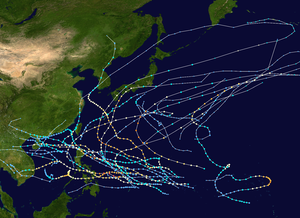
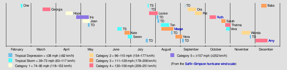
The 1964 Pacific typhoon season was the most active tropical cyclone season recorded globally, with a total of 39 tropical storms forming. It had no official bounds; it ran year-round in 1964, but most tropical cyclones tend to form in the northwestern Pacific Ocean between June and December. These dates conventionally delimit the period of each year when most tropical cyclones form in the northwestern Pacific Ocean.

<span class="mw-page-title-main">1963 Pacific typhoon season</span>

The 1963 Pacific typhoon season has no official bounds; it ran year-round in 1963, but most tropical cyclones tend to form in the northwestern Pacific Ocean between June and December. These dates conventionally delimit the period of each year when most tropical cyclones form in the northwestern Pacific Ocean.

<span class="mw-page-title-main">Typhoon Rose (1971)</span> Pacific typhoon in 1971

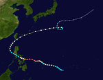
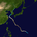
Typhoon Rose, known in the Philippines as Typhoon Uring, was the most violent and intense tropical cyclone to strike Hong Kong since Typhoon Wanda in 1962. The 21st named storm of the 1971 Pacific typhoon season, Rose developed from an area of disturbed weather while west of Guam on August 9. Moving west-northwestward, the storm briefly became a typhoon on the following day. After weakening to a tropical storm on August 11, Rose re-intensified into a typhoon several hours later. The system then curved westward and reached a primary peak intensity with winds of 205 km/h (127 mph) on August 13. Later that day, the typhoon made landfall near Palanan, Isabela in the Philippines. Rose weakened significantly while crossing the island of Luzon and was a minimal typhoon upon reaching the South China Sea on August 14.

<span class="mw-page-title-main">Typhoon Roy</span> Pacific typhoon in 1988

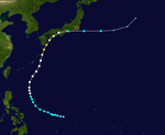
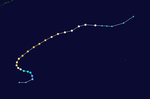
Typhoon Roy, known in the Philippines as Typhoon Asiang, was the second-most intense January tropical cyclone on record in the Western Pacific basin. Forming out of an area of disturbed weather on January 7, 1988, Roy quickly intensified as it moved through the Marshall Islands. By January 9, the storm intensified into a typhoon and attained its peak intensity the following day. At its peak, sustained winds reached 215 km/h (135 mph). Slight weakening took place before the storm moved through the Mariana Islands. Continuing westward, the system eventually struck the Philippines as a minimal typhoon before dissipating over the South China Sea on January 19.

<span class="mw-page-title-main">Typhoon Alex (1987)</span> Pacific typhoon in 1987

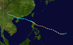
Typhoon Alex, known in the Philippines as Typhoon Etang, affected the Taiwan, China, and South Korea during July 1987. Typhoon Alex developed from the monsoon trough that spawned a tropical disturbance late on July 21 southwest of Guam which organized into a tropical depression shortly thereafter. The system steadily became better organized, and the next day, a tropical depression had developed. Satellite intensity estimates gradually increased, and on July 23, the depression intensified into Tropical Storm Alex. After initially tracking west-northwest, Tropical Storm Alex started tracking northwest. An eye developed on July 24, and on the next day, Alex was classified as a typhoon, when Alex attained its peak intensity of 120 km/h (75 mph) and a minimum barometric pressure of 970 mbar (29 inHg). Alex weakened while tracking more northward, though interaction with Taiwan resulted in a more westward track starting on July 27. The storm struck near Shanghai as a tropical storm, and weakened over land, although it remained identifiable through August 2.

<span class="mw-page-title-main">Typhoon Amy (1951)</span> Pacific typhoon in 1951

Typhoon Amy was an intense and deadly tropical cyclone that struck areas of the central Philippines in December 1951. Impacting the archipelago during the 1951 eruption of Mount Hibok-Hibok, Amy exacerbated the effects of the volcano, greatly increasing the number of resulting deaths. The fifteenth named storm and fourteenth typhoon within the western Pacific Ocean that year, Amy developed from an area of low pressure near the Kwajalein Atoll on December 3. Tracking in a general westward direction, the storm quickly intensified to reach typhoon intensity the next day. However, the typhoon's asymmetricity resulted in a fluctuation of intensity over the following few days. Afterwards, Amy intensified to reach its peak intensity with maximum sustained winds of 220 km/h (140 mph) and a minimum barometric pressure of 950 mbar on December 8. Over the ensuing two days, Amy moved over several islands in the central Philippines before emerging in the South China Sea on December 11 as the equivalent of a minimal typhoon. Shortly after, the tropical cyclone executed a tight anticyclonic loop while oscillating in strength several times before eventually weakening and dissipating on December 17, just east of Vietnam.

<span class="mw-page-title-main">Typhoon Lynn</span> Pacific typhoon in 1987

Typhoon Lynn, more commonly known in the Philippines as Typhoon Pepang, was responsible for the worst flooding in Taiwan in 40 years. Typhoon Lynn originated from an area of disturbed weather in the central north Pacific in mid-October 1987. On October 15, the system was upgraded into a tropical storm. Moving west-northwest, it slowly deepened over the next few days, though the intensification process briefly stopped on October 15. Two days later, Lynn was upgraded into a typhoon, while passing northwest of Guam. Lynn maintained low-end typhoon strength until October 19, when the storm began to rapidly intensify. On October 21, Lynn attained its peak intensity while tracking towards the west. Weakening then commenced soon after Lynn interacted with Luzon. However, the core of the typhoon remained well offshore both the Philippines and Taiwan. On October 25, Lynn weakened to a severe tropical storm. Three days later, it dissipated, though its remains later brought rain to China.

<span class="mw-page-title-main">Typhoon Nancy (1982)</span> Pacific typhoon in 1982

Typhoon Nancy, known in the Philippines as Typhoon Weling, was a destructive typhoon that moved through Vietnam and the Philippines during October 1982. The typhoon originated from an area of convection and was first classified as a tropical cyclone on October 10. The system attained gale-force winds the next day, and slowly deepened thereafter. Although Nancy initially moved west, the system maintained a general westward course for much of its duration, striking Luzon on October 14 at peak intensity of 215 km/h (130 mph). It weakened to tropical storm strength overland, but re-intensified to typhoon intensity over the South China Sea. Nancy hit northern Vietnam on the October 18, and weakened almost immediately thereafter, before dissipating on October 20 inland over Vietnam.

<span class="mw-page-title-main">Typhoon Gilda (1959)</span> Pacific typhoon in 1959

Typhoon Gilda was an intense tropical cyclone that struck regions of the central Philippines in December 1959. An unusually strong late-season storm, Gilda developed on December 13 from a disturbance first identified southeast of Chuuk State three days prior. Steadily intensifying, Gilda reached typhoon strength the next day and proceeded in a general westward track towards the Philippines. On December 18, the typhoon peaked with maximum sustained winds of 280 km/h (175 mph) shortly before the storm made landfall on Samar with a slightly weakened intensity. After passing into the South China Sea, Gilda steadily weakened and made a final landfall in southern Vietnam before dissipating on December 22 over Cambodia. Damage in the Philippines was extensive, and in some locations telecommunications were cut. Impacts in Samar were particularly severe, and in some areas the damage was the worst in 30 years. Homes and crops sustained significant losses. Overall, Gilda caused the deaths of 23 in the Philippines and US$1.5 million in damage.

<span class="mw-page-title-main">Typhoon Kim (1980)</span> Pacific typhoon in 1980

Typhoon Kim, known in the Philippines as Typhoon Osang, was the second typhoon in a week to directly affect the Philippines during July 1980. Like Typhoon Joe, Kim formed from the near equatorial monsoon trough in the northwestern Pacific Ocean on July 19. The disturbance tracked quickly westward-northwest underneath a subtropical ridge, reaching tropical storm strength on the July 21 and typhoon strength on July 23. After developing an eye, Kim began to rapidly intensify, and during the afternoon of July 24, peaked in intensity as a super typhoon. Several hours later, Kim made landfall over the Philippines, but the storm had weakened considerably by this time. Throughout the Philippines, 40 people were killed, 2 via drownings, and 19,000 others were directly affected. A total of 12,000 homes were destroyed and 5,000 villages were flooded. Less than a week earlier, the same areas were affected by Joe; however, Kim was considered the more damaging of the two typhoons. Land interaction took its toll on Kim, and upon entering the South China Sea, the storm was down below typhoon intensity. Kim continued northwestward but its disrupted circulation prevented re-intensification, and it remained a tropical storm until hitting southern China July 27 to the northeast of Hong Kong, where only slight damage was reported. Later that day, Kim dissipated.

<span class="mw-page-title-main">Typhoon Cary (1987)</span> Pacific typhoon in 1987

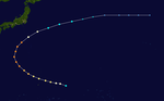
Typhoon Cary, known as Typhoon Ising in the Philippines, was the second of two tropical cyclones to affect Vietnam in a week. An area of disturbed weather developed southwest of Pohnpei on August 6, 1987. The system initially remained disorganized, but by August 14, Cary had attained tropical storm intensity. After initially moving north-northwest, Cary turned west-northwest, although intensification was slow to occur. On August 15, Cary was upgraded into a typhoon, and on August 17, the typhoon peaked in intensity. Typhoon Cary then made landfall in northern Luzon while at peak intensity. Across the Philippines, 954 houses were damaged and an additional 89 were destroyed, which left 55,567 people, or 13,247 families that were either homeless or otherwise sought shelter. Five people died in the country while damage totaled $5.58 million (1987 USD), including $1.45 million from agriculture and $4.13 million from infrastructure. The storm weakened over land, but re-intensified into a typhoon over the South China Sea. On August 21, Typhoon Cary passed just south of Hainan, where hundreds of homes were damaged but no fatalities occurred, and subsequently entered the Gulf of Tonkin. The storm weakened as it approached Vietnam, and on August 23, the storm dissipated inland over Laos. Across Vietnam, almost 40,000 ha of land were flooded or destroyed. Twenty people were killed and many others were injured.

<span class="mw-page-title-main">Typhoon Betty (1980)</span> Pacific typhoon in 1980

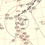
Typhoon Betty, known in the Philippines as Typhoon Aring, was the strongest typhoon to strike the Philippines in ten years. An area of disturbed weather developed on October 27, 1980, near Truk Atoll. After turning east from south, the disturbance was classified as a tropical storm on October 29 as it passed near Guam, causing only minor damage. Following a turn to the west-northwest, Betty attained typhoon intensity the next day. On November 4, Betty peaked in intensity. Later that day, Betty moved ashore over Luzon, introducing a rapid weakening trend. Over land, Betty then began to turn north due to a weakening subtropical ridge to its north and a trough offshore Taiwan. By November 8, Betty, after moving offshore, had completed its transition into an extratropical cyclone, and dissipated that same day.
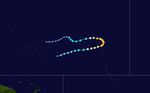
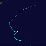
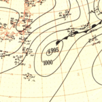
<span class="mw-page-title-main">Typhoon Warren</span> Pacific typhoon in 1988

Typhoon Warren, known in the Philippines as Typhoon Huaning, struck the Philippines and China during July 1988. An area of disturbed weather developed within the vicinity of the Caroline Islands during the second week of July. A tropical depression developed southeast of Guam on July 12, and on the next day, intensified into a tropical storm. Tracking generally west-northwest, Warren deepened into a typhoon on July 14. The storm subsequently entered a period of rapid intensification, commencing with Warren reaching its highest intensity on July 16. The following evening, the typhoon brushed Luzon, resulting in a weakening trend, although Warren was still a typhoon when it made landfall near Shantou. Warren rapidly dissipated inland.

<span class="mw-page-title-main">Typhoon Eli</span> Pacific typhoon in 1992

Typhoon Eli, known in the Philippines as Typhoon Konsing, struck the Philippines and Hainan during mid-July 1992. A weak low pressure system developed in the Philippine Sea on July 7, which became a tropical depression on the next day. The depression tracked west-northwest and strengthened into a tropical storm on July 10. After turning more westward, Eli steadily intensified, and obtained typhoon intensity that evening. The storm attained its highest intensity of 130 km/h (80 mph) early on July 11 before striking northern Luzon. After entering the South China Sea, the storm maintained most of its intensity as it approached Hainan, although agencies disagree on how precisely strong it was. After passing through Hainan late on July 13, Eli passed through the Gulf of Tonkin on the next day before striking Vietnam, where Eli quickly dissipated.
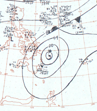
<span class="mw-page-title-main">Typhoon Louise–Marge</span> Pacific typhoon in 1964

Typhoon Louise–Marge, known in the Philippines as Typhoon Ining–Liling, was a powerful tropical cyclone that impacted Palau and the Philippines in November 1964. It was one of the most destructive typhoons documented in the central Philippines. Tracking data from meteorological agencies disagree whether the storm was a single tropical cyclone or two distinct tropical cyclones that occurred in quick succession, named separately by the Joint Typhoon Warning Center (JTWC) as Louise and Marge. Louise–Marge's peak intensity and first landfall on the Philippines were associated with the Louise portion of the storm's history, while the Marge portion was weaker and shorter lived.

References

  1. 1 2 3 4 5 6 7 8 9 10 11 Pate, Elbert W.; Taylor, George F. (September 1951). Operation Greenhouse (Technical Meteorological Report). Defense Technical Information Center. Archived from the original (PDF) on August 1, 2013. Retrieved 18 July 2013.
  2. 1 2 3 4 "IrBTRACS For the Northern Hemisphere" (FTP). International Best Track Archive for Climate Stewardship. United States National Oceanic and Atmospheric Administration's National Climatic Data Center. Retrieved 19 July 2013.
  3. Digital Typhoon (March 19, 2013). "Typhoon 195102 (GEORGIA)". Digital Typhoon Detailed Track Information. National Institute of Informatics. Retrieved 18 July 2013.
  4. "Typhoon Heading For Atomic Blast Testing Grounds At Eniwetok". Schenectady Gazette. Vol. 57, no. 149. Schenectady, New York. Associated Press. March 22, 2013. pp. 1, 10. Retrieved 18 July 2013.
  5. "Typhoon Blows Itself Out In Eniwetok Area". The Telegraph-Herald. Vol. 115, no. 72. Dubuque, Iowa. Associated Press. March 25, 2013. p. 23. Retrieved 18 July 2013.
  6. "Operation Greenhouse - 1951". SonicBomb. September 15, 2010. Retrieved 18 July 2013.[ permanent dead link ]
  7. 1 2 3 4 5 6 7 8 9 10 11 Air Weather Service; Military Air Transport Service; United States Air Force (September 1951). 1951 Annual Report Of Typhoon Post-Analysis Program (PDF) (Air Weather Service Technical Report). Washington, D.C.: Defense Technical Information Center. Archived from the original (PDF) on 3 March 2016. Retrieved 20 July 2013.
  8. 1 2 3 4 "1951 02W:HOPE (1951105N08152)". International Best Track Archive for Climate Stewardship. University of North Carolina-Asheville. Retrieved 20 July 2013.
  9. Climatological Division of the Philippine Atmospheric, Geophysical, and Astronomical Services Administration (August 25, 2010). Tropical Cyclones. Philippine Atmospheric, Geophysical, and Astronomical Services Administration.
  10. 1 2 3 China Meteorological Administration. "China Meteorological Administration Best Track Data For the 1951 Pacific Typhoon Season". National Climatic Data Center. Retrieved 20 July 2013.
  11. 1 2 3 4 5 6 7 "1951 03W:IRIS (1951119N06145)". International Best Track Archive for Climate Stewardship. University of North Carolina-Asheville. Retrieved 20 July 2013.
  12. Digital Typhoon (March 19, 2013). "Typhoon 195104 (IRIS)". Digital Typhoon Detailed Track Information. National Institute of Informatics. Retrieved 20 July 2013.
  13. 1 2 "Typhoon Takes South Luzon Toll". New York Times. Manila, Philippines. IMP. May 6, 1951. Retrieved 20 July 2013.(subscription required)
  14. Hernandez, Pedro P.; Koh, Severino L. (1951). "Tropical Cylones of 1951". Manila, Philippines: Philippines Weather Bureau Press.{{cite journal}}: Cite journal requires |journal= (help)
  15. "1951 04W:JOAN (1951124N04167)". International Best Track Archive for Climate Stewardship. University of North Carolina-Asheville. Archived from the original on December 23, 2018. Retrieved December 22, 2018.
  16. 1 2 "1951 05W:KATE (1951177N12136)". International Best Track Archive for Climate Stewardship. University of North Carolina-Asheville. Archived from the original on December 23, 2018. Retrieved December 22, 2018.
  17. Digital Typhoon (June 1, 1981). "Typhoon 195106 (KATE)". Digital Typhoon Detailed Track Information. National Institute of Informatics. Retrieved December 22, 2018.
  18. 1 2 "Typhoon Kills 13 On Nippon Island". Democrat and Chronicle. Vol. 119. Rochester, New York. Associated Press. July 2, 1951. p. 4. Retrieved December 21, 2018 via Newspapers.com. Open Access logo PLoS transparent.svg
  19. 1 2 "1951 06W:LOUISE (1951206N11145)". International Best Track Archive for Climate Stewardship. University of North Carolina-Asheville. Archived from the original on December 24, 2018. Retrieved December 23, 2018.
  20. 1 2 "10 Killed, Much Damage Caused by Luzon Typhoon". Honolulu Star-Bulletin. Vol. 58, no. 18368. Honolulu, Hawwaii. Associated Press. August 1, 1951. p. 16. Retrieved December 23, 2018 via Newspapers.com. Open Access logo PLoS transparent.svg
  21. "150-MPH Typhoon Rips Area In Philippines". Journal Herald. Vol. 144, no. 181. Dayton, Ohio. Associated Press. July 30, 1951. p. 8. Retrieved December 22, 2018 via Newspapers.com. Open Access logo PLoS transparent.svg
  22. "Philippine Typhoon Roars Into China Sea". The Battle Creek Enquirer and News. Vol. 52. Battle Creek, Michigan. Associated Press. July 30, 1951. p. 4. Retrieved December 22, 2018 via Newspapers.com. Open Access logo PLoS transparent.svg
  23. "Luzon Typhoon". The Rapid City Daily Journal. Rapid City, South Dakota. Associated Press. July 31, 1951. Retrieved December 22, 2018 via Newspapers.com. Open Access logo PLoS transparent.svg
  24. "19 Inches of Rain in Luzon Typhoon". Wilkes-Barre Times Leader. Wilkes-Barre, Pennsylvania. Associated Press. July 31, 1951. Retrieved December 22, 2018 via Newspapers.com. Open Access logo PLoS transparent.svg
  25. "Typhoon Toll Hits 6". Austin American-Statesman. Vol. 38, no. 64. Austin, Texas. Associated Press. August 2, 1951. p. 11. Retrieved December 22, 2018 via Newspapers.com. Open Access logo PLoS transparent.svg
  26. Henderson, Faye (1979). Tropical Cyclone Disasters in the Philippines (PDF) (Report). Washington, D.C.: United States Agency for International Development. Retrieved 24 December 2018.
  27. "1951 07W:MARGE (1951223N11148)". International Best Track Archive for Climate Stewardship. University of North Carolina-Asheville. Archived from the original on December 25, 2018. Retrieved December 24, 2018.
  28. National Summary (Report). Climatological Data. Vol. 30. Asheville, North Carolina: National Oceanic and Atmospheric Administration. January 1979. p. 96 via Google Books.
  29. Simpson, Robert H. (September 1952). "Exploring Eye of Typhoon "Marge," 1951". Bulletin of the American Meteorological Society. Washington, D.C.: American Meteorological Society. 33 (7): 286–298. doi: 10.1175/1520-0477-33.7.286 . Open Access logo PLoS transparent.svg
  30. "65th Anniversary of Typhoon Marge flight". Hurricane Research Division. Miami, Florida: National Oceanic and Atmospheric Administration. August 15, 2016. Retrieved 24 December 2018.
  31. "Approaching Typhoon Forces U.N. Ships Off Korea to Move". St. Louis Post-Dispatch. Vol. 103, no. 330. St. Louis, Missouri. Associated Press. August 17, 1951. p. 6A. Retrieved December 23, 2018 via Newspapers.com. Open Access logo PLoS transparent.svg
  32. "Pacific Typhoon". The Leader-Post. Vol. 47, no. 194. Regina, Saskatchewan. Reuters. August 18, 1951. p. 5. Retrieved December 23, 2018 via Newspapers.com. Open Access logo PLoS transparent.svg
  33. "Okinawa Rides Out Typhoon". Muncie Evening Press. Vol. 59, no. 167. Muncie, Indiana. International News Service. August 21, 1951. p. 7. Retrieved December 23, 2018 via Newspapers.com. Open Access logo PLoS transparent.svg
  34. "Storm Sweeps China Sea". Windsor Daily Star. Vol. 66, no. 144. Windsor, Manitoba. United Press. August 18, 1951. p. 1. Retrieved December 23, 2018 via Newspapers.com. Open Access logo PLoS transparent.svg
  35. "Typhoon Skirts Japan; Six Dead". St. Petersburg Times. Vol. 68, no. 27. St. Petersburg, Florida. Associated Press. August 20, 1951. p. 17. Retrieved December 23, 2018 via Newspapers.com. Open Access logo PLoS transparent.svg
  36. "Heavy Loss In Typhoon". Mt. Pleasant News. Vol. 76, no. 195. Mt. Pleasant, Iowa. International News Service. August 19, 1951. p. 2. Retrieved December 23, 2018 via Newspapers.com. Open Access logo PLoS transparent.svg
  37. "Typhoon Hits Korea, Destroys Pusan Homes". The Gazette. Montreal, Quebec. Reuters. August 24, 1951. p. 1. Retrieved December 23, 2018 via Newspapers.com. Open Access logo PLoS transparent.svg
  38. "Luzon Storm Swept". The Palm Beach Post. Vol. 43, no. 175. West Palm Beach, Florida. Associated Press. September 3, 1951. p. 6. Retrieved December 22, 2018 via Newspapers.com. Open Access logo PLoS transparent.svg
  39. "Typhoon Hits Hainan". Vancouver Sun. Vol. 45, no. 272. Vancouver, British Columbia. Reuters. September 3, 1951. p. 7. Retrieved December 23, 2018 via Newspapers.com. Open Access logo PLoS transparent.svg
  40. Roth, David M. (June 15, 2020). "Tropical Cyclone Point Maxima". Weather Prediction Center. Retrieved 6 October 2020.
  41. "Typhoon 'Ruth' Swirls Toward Japan's Coast". The Spokesman-Review. Spokane, Washington. Reuters. October 14, 1951. p. 5 via Newspapers.com.
  42. "Winds Send Troopship Onto Jap Island Shoal". Fort Worth Star-Telegram. No. 257. Fort Worth, Texas. Associated Press. October 15, 1951. p. 1. Retrieved May 15, 2020 via Newspapers.com.
  43. 1 2 3 Kitamoto, Asanobu. "Typhoon 195115 (RUTH)". Digital Typhoon. National Institute of Informatics. Retrieved May 15, 2020.
  44. 1 2 "ルース台風". 災害をもたらした気象事例 (in Japanese). Tokyo, Japan: Japan Meteorological Agency. Retrieved May 23, 2020.
  45. "Typhoon Damages Rice". Fort Worth Star-Telegram. No. 263. Fort Worth, Texas. Reuters. October 21, 1951. p. 12. Retrieved May 15, 2020.
  46. "Typhoon Hits U.S. Troopship Aground Off Japanese Coast". The Scranton Tribune. Scranton, Pennsylvania. United Press. October 15, 1951. p. 1. Retrieved May 15, 2020 via Newspapers.com.
  47. "Typhoon Ruth - 14-15 October 1951". Anzac Day Commemoration Committee. ANZAC Day Commemoration Committee (Queensland) Incorporated. Retrieved May 15, 2020.
  48. "Transfer 500 From Wrecked Ship". The Mt. Pleasant News. Vol. 73, no. 243. Mount Pleasant, Iowa. International News Service. October 15, 1951. p. 1. Retrieved May 15, 2020 via Newspapers.com.
  49. "Typhoon Blows Out Harmlessly". The Elwood Call-Leader. No. 245. Elwood, Indiana. International News Service. October 16, 1951. p. 6. Retrieved May 15, 2020 via Newspapers.com.
  50. "Nearly 500 Die in Jap Typhoon". Visalia Times-Delta. No. 174. Visalia, California. Associated Press. October 17, 1951. p. 1. Retrieved May 15, 2020 via Newspapers.com.
  51. http://atms.unca.edu/ibtracs/ibtracs_v03r09/browse-ibtracs/index.php?name=v03r09-1951300N13155%5B%5D
  52. Clarence Paul Oaminal (January 5, 2015). "The calamities of 1951 and the President's action". The Philippine Star. Retrieved December 21, 2016.
  53. 1 2 3 "1951 16W:AMY (1951337N09150)". International Best Track Archive for Climate Stewardship. University of North Carolina-Asheville. Retrieved 20 July 2013.
  54. 1 2 3 Alojado, Dominic (July 29, 2010). "The Twelve Worst Typhoons Of The Philippines (1947 –2009)". Typhoon2000.com. Retrieved 26 July 2013.
  55. "Philippines Threatened By Typhoon". The Victoria Advocate. Victoria, Texas. Associated Press. December 9, 1951. p. 1A. Retrieved 21 July 2013.
  56. "Typhoon Kills 3, Volcano Erupts Again". The Victoria Advocate. Vol. 6, no. 186. Victoria, Texas. Associated Press. December 10, 1951. p. 2. Retrieved 21 July 2013.
  57. White, Frank L. (December 13, 1951). "569 Perish in Typhoon". The Ludington Daily News. Vol. 62, no. 34. Ludington, Michigan. Associated Press. p. 1. Retrieved 27 July 2013.
  58. "Philippine Typhoon Kills At Least 14". Nashua Telegraph. Vol. 83, no. 238. Nashua, New Hampshire. Associated Press. December 10, 1951. p. 8. Retrieved 21 July 2013.
  59. Naval Meteorology and Oceanography Command. "Cebu Port Study". Monterrey, California: Navy Research Laboratory. Archived from the original on 12 November 2016. Retrieved 21 July 2013.
  60. Naval Meteorology and Oceanography Command. "Most Disastrous Tropical Cyclones Affecting Cebu Province Selection By Year From 1948 –2012". Monterrey, California: Navy Research Laboratory. Retrieved 21 July 2013.
  61. "23 Killed, 200 Lost In Typhoon". Miami Daily News. Vol. 56, no. 313. Miami, Florida. Associated Press. December 11, 1951. p. 13A. Retrieved 26 July 2013.[ permanent dead link ]
  62. "Typhoon Causes Heavy Damage". The Spokesman-Review. Vol. 69, no. 211. Spokane, Washington. Associated Press. December 11, 1951. p. 2. Retrieved 26 July 2013.
  63. "16 Known Dead From Typhoon In Philippines". The News and Courier. Charleston, South Carolina. Associated Press. December 11, 1951. p. 2A. Retrieved 26 July 2013.[ permanent dead link ]
  64. 1 2 3 "Two Typhoons Menace Manila". Sarasota Herald-Tribune. Vol. 27, no. 61. Sarasota, Florida. Associated Press. December 12, 1951. p. 1. Retrieved 27 July 2013.
  65. 1 2 "Typhoon Rips Philippines". Pittsburgh Post-Gazette. Vol. 25, no. 113. Pittsburgh, Pennsylvania. Associated Press. December 11, 1951. p. 1. Retrieved 26 July 2013.
  66. 1 2 Centre for Research on the Epidemiology of Disasters. "EM-DAT: The Emergency Events Database" . Université catholique de Louvain.
  67. Digital Typhoon (October 17, 1990). "Typhoon 195101 (NO-NAME)". Digital Typhoon Detailed Track Information. National Institute of Informatics. Retrieved 18 July 2013.