The 1957 Pacific typhoon season has no official bounds; it ran year-round in 1957, but most tropical cyclones tend to form in the northwestern Pacific Ocean between June and December. These dates conventionally delimit the period of each year when most tropical cyclones form in the northwestern Pacific Ocean.
The scope of this article is limited to the Pacific Ocean, north of the equator and west of the International Date Line. Storms that form east of the date line and north of the equator are called hurricanes; see 1957 Pacific hurricane season. Tropical storms formed in the entire west Pacific basin were assigned a name by the Fleet Weather Center on Guam.
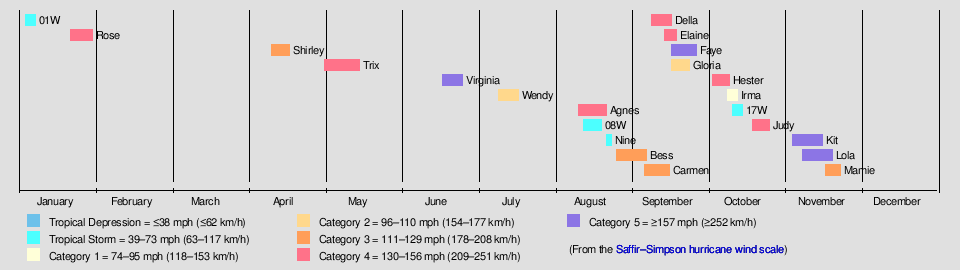
The accumulated cyclone energy (ACE) index for the 1957 Pacific typhoon season as calculated by Colorado State University using data from the Joint Typhoon Warning Center was 440.2 units, which is the seventh highest ACE for a single season ever recorded.[2] Twenty-two tropical storms developed in 1957 in the Northwestern Pacific. Tropical depressions were likely, but no records are known to exist that would mention any. Eighteen storms reached typhoon intensity, of which 8 reached super typhoon strength. An additional storm, Della, came across the Dateline from the Central Pacific, therefore it is not taken account in the total number of storms.
The first tropical cyclone of the 1957 season, classified as Tropical Storm 01W by the JTWC,[3] was initially identified early on January3 as a tropical depression over open waters east of the Philippines.[4][5] Within several hours, the system intensified into a tropical storm as it tracked west-northwestward. Later that day, the storm attained its peak intensity with winds of 45mph (72km/h)[4] and a barometric pressure of 995 millibars (29.4inHg).[5] Tropical Storm 01W maintained this intensity through January5 before abruptly weakening to a tropical depression near the eastern Philippines. The system made landfall in eastern Leyte early on January6 with winds of 35mph (56km/h) before dissipating the following day over Romblon.[4][5]
About two weeks after Tropical Storm 01W dissipated over the Philippines, a new tropical depression formed to the southeast of Guam on January21. Gradual intensification took place as the depression tracked westward.[5] The JTWC began monitoring the system as Tropical Storm Rose the following day,[3] with the first advisory on the storm placing maximum winds at 50mph (80km/h). Rose maintained this intensity for roughly 24hours before undergoing a brief period of rapid intensification, attaining winds of 110mph (180km/h) early on January23. For most of the day, the now Category2 typhoon, strengthened at a more modest rate before undergoing a second brief period of rapid intensification. At the end of the second strengthening phase, Rose had attained its peak intensity just at Category5 status, on the modern-day Saffir–Simpson Hurricane Scale, with winds of 160mph (260km/h),[6] and a minimum pressure of 920 millibars (27inHg).[5] Upon attaining this intensity, Rose became the most intense January typhoon on record, surpassing that of Super Typhoon Karen in 1948.[6][7]
After attaining its peak intensity, Rose began to take a more northerly track and weakened. Late on January25, Rose rapidly weakened to a low-end typhoon and by January26, the system had further weakened to a tropical storm. The JTWC continued to monitor the weakening tropical storm until January27, by which time Rose had maximum winds of 40mph (64km/h).[6] However, the JMA continued monitoring the remnants of Rose as it turned sharply eastward over open waters. During the afternoon of January28, the depression nearly stalled as it turned northward before accelerating and losing its identity south of Japan on January30.[5]
Shirley formed on April 11 east of the Philippines. It moved north and intensified to its brief peak of 115mph (185km/h) winds and a pressure of 975mbar on April 15. Shirley then turned to the northwest and weakened to a tropical storm on April 16. Shirley turned to the west and dissipated on April 18 near the northern end of Luzon.
Trix formed on May 2 near the Marshall Islands. It moved north briefly on May 3 and May 4, intensified to its peak of 140mph (230km/h) on May 5, and then turned to the west-northwest. Trix turned to the north on May 9 and to the east-northeast on May 10, weakening to a Category2 typhoon on May 11. Trix continued to move northeast and weakened to a Category 1 typhoon on May 13. It dissipated on May 17 just over the Date Line without affecting any land.
Virginia formed on June 18 in the open western Pacific east of the southern Philippines. It moved west and strengthened to a typhoon on June 20 and reached its peak of 175mph (282km/h)and a minimum central pressure of 900 mbar on June 22. Virginia then began to move northwest and weakened to a Category4 typhoon as it passed east of Luzon on June 23 and June 24. It turned northward on June 24, strengthened to a secondary peak of 160mph (260km/h), and weakened before it made landfall in Taiwan on June 25 as a Category2 typhoon. Virginia then continued to move north and then northeast until its dissipation on June 28.
Virginia was an early season typhoon. It destroyed 1,000 buildings and killed 86people as it sliced through Taiwan and southern Japan. The storm left $20million (1957USD) in damage.[8]
According to the International Best Track Archive for Climate Stewardship, Wendy originated from a tropical depression well east of the Philippines on July 10. Developing into a tropical storm several hours later, further development would occur as Wendy tracked northwestwards. As a result, around three days later, the system became a typhoon. Further intensification occurred, and around 15:00 UTC on July 14, Wendy peaked with sustained winds of 90 knots (100 mph) and a minimum pressure of 985 hPa. However, around that time, Wendy made its first landfall in Luzon, causing it to weaken into a Category 1-equivalent typhoon the next day. Although it temporarily reintensified, attaining a secondary peak with sustained winds of 80 knots (90 mph) around that time, it began rapidly weakening, making its final landfall in Guangdong, China as a high-end tropical storm. Once inland, Wendy rapidly weakened, dissipating on July 16.[9]
Prior to striking the nation, the Hong Kong Observatory hoisted a No. 5 storm signal as Wendy was expected to strike the nation. This was later upgraded to a No. 6 storm signal when Wendy made its closest approach to Hong Kong. Two cruisers from the Royal Navy left the colony. Due to the typhoon's winds, American billionaire Nelson Rockefeller had to divert his plane to the colony.[10][11] Despite these preparations, Wendy's impacts in Hong Kong were severe. Striking the island with gusts of 95 knots (110 mph) and torrential rainfall, the typhoon killed sixteen and injured a further two hundred. These included two boys who were killed when their huts collapsed on them and another boy who was also killed when he drowned in the sea surrounding West Point. The roof and rear of four homes collapsed, blocking all of Stavely Street. The SS Tweed Breeze broke from its buoy and ran aground in Stonecutter's Island, while parts of Taipo Road became inaccessible due to collapsing.[12][13][14][15] Elsewhere, in the Philippines, Wendy brought flooding which killed at least seventy-six, most of them children, and made a further three hundred go missing.[16][17] This flooding also displaced around thirty thousand people and destroyed several towns. Damage there amounted to $2 million (1957 USD). Elsewhere, in China's Guangdong Province, over three hundred-thousand people were mobilized to gather crops and take safety precautions due to the storm. Offshore Guangdong Province, eight people died when their fishing boat sank due to Wendy. Additionally, estimates indicated that around a fifth of the unharvested rice in the province was destroyed. Although Wendy did bring some gale-force winds to Taiwan, no damage was reported there.[18][19]
On August 12, the seventh storm of the season formed. Agnes moved in an erratic northern direction until August 16, when it briefly turned to the northwest toward China. Agnes then began to curve towards the north, passing over one of the Ryukyu Islands with 155mph winds and a minimum central pressure of 905mbar. After it passed over the islands, Agnes weakened to tropical storm strength. On August 21, South Korea was struck by a 50mph Agnes; their 1st[clarification needed] tropical cyclone of the season. It passed over the peninsula and briefly was over water before it hit Russia with 45mph winds. Agnes became extratropical the next day over southern Russia. Its extratropical form continued for two more days until it dissipated in the center of the Sea of Okhotsk.
08W formed on August 15, becoming the 8th of the season. It moved in a generally westward direction for a couple days until it struck Hainan on August 18 with 65mph winds and a minimum pressure of 984mbar. It moved south over land, retaining its strength. It soon moved north again, but suddenly turned southwest for a brief time before it returned to its original path. It weakened to a tropical depression on August 20 and struck mainland China later that day. It almost became extratropical almost at the same time. Ex-08W lingered northeast until the 24th, when the last of it was gone after ten days in existence.
A disturbance close to Japan's coast developed into a tropical depression on August 22, and became a tropical storm 6hours later. It managed to achieve a minimum central pressure of 999mbar before it struck the southeastern portion of Japan. It weakened to a tropical depression shortly before landfall though, and became extratropical the next day. But its extratropical remnants continued to move north-northeast, then northeast, and then east-northeast until it dissipated on August 27.
Bess formed on August 26 close to the Marshall Islands. After moving westward, Bess attained Category3 status with 115mph winds a pressure of 950mbar. It hit southern Japan on September 6 and later became extratropical over water on September 9. But the extratropical form of Bess continued east for one more day before it became disorganized enough to be declared dissipated.
On August30, the typhoon battered the United States military base on Iwo Jima with winds of 110mph (180km/h), resulting in communication loss for roughly 23hours. After communication was restored, officials on the island stated that there was likely no loss of life as a result of the storm.[20] Little damage also took place throughout Iwo Jima.[21]
Widespread damage took place throughout Kyushu as wind gusts up to 115mph (185km/h) and torrential rains impacted the region.[22] Along coastal regions, waves exceeding 13ft (4.0m) caused significant coastal damage.[23] In Kyushu, at least six people were killed, 14 others listed as missing and 28 more injured as a result of Bess.[24] According to police reports, 912 homes were destroyed and 1,522 others were severely damaged by flooding and landslides triggered by Typhoon Bess.[22] An additional 2,510 homes sustained minor damage.[24] Throughout Japan, an estimated 24,000 people were left homeless in the wake of the storm.[22] In all, at least 20 people were killed as a result of Bess in Japan.[25]
Carmen formed on September 9 north-northeast of the Philippines. It slowly moved north and the west over the course of three days, until it strengthened to a tropical storm. Carmen headed south briefly before heading east-northeast, when it began to strengthen even more. Carmen reached winds of 125mph and a pressure of 960mbar. But shortly thereafter, the strengthening stopped, and it slowly weakened. On September 15, Carmen made landfall in southern China and dissipated the following day.
A disturbance in the Intertropical Convergence Zone developed into Tropical Storm Della on September 1. Della moved west-northwestward, strengthening to a hurricane while west of Hawaii. There, it brought heavy surf to the western islands. The hurricane continued generally westward, moving to the southwest while crossing the International Date Line. It turned westward and the northwestward. During its long northwestward trek, Della reached its peak intensity of 140mph and a minimum central pressure of ≤960mbar. On September 14, Della began to travel a completely opposite direction-northeast. It continued that direction for a number of days, until it reached the Dateline as a 70mph tropical storm. As the storm was crossing the date line, it turned sharply to the north-northeast. A few days later, Della turned east-northeast and dissipated on September 18.
On September 14, in the open Pacific, Elaine was formed. It moved in a generally northwestward direction while gaining strength. Its peak intensity was 140mph and a pressure of 945mbar. But it turned sharply to the northeast and lost strength. On its penultimate day as a tropical cyclone, it turned eastward and became extratropical the next day. Elaine's extratropical form continued one more day, and dissipated, one week since its formation, just over the Dateline.
Faye formed on September 18. It strengthened at a moderate pace until it reached its peak of 160mph (260km/h) and 930mbar. After weakening, it struck Okinawa as a Category 2 typhoon; Faye battered the island, which was still recovering from Typhoon Emma that struck the same area a year ago. 53people died in its wake, while 79 were listed as missing. Faye also left damages, straining the expensive budget caused by past and future typhoons that struck the island. Faye passed over the Date Line and shortly after became extratropical on the last day of the month, but continued one more day as an extratropical system before it met its demise.[citation needed]
Gloria formed on September 17. After crossing the Philippines as a category two, it brought hurricane winds to Hong Kong and strong winds to Macau.[26] After landfall, it moved east and met its demise on September 24. It had a minimum central pressure of 980mbar and maximum winds of 105mph.
Hester formed on October 3, several hundred miles east of the Philippines. At first, it slowly intensified, then rapid intensification occurred, reaching its peak strength of 150mph while southeast of Japan. It then gradually weakened, weakening to a tropical storm southeast of the Kamchatka Peninsula. It then further weakened, dissipating just north of the Aleutian Islands.
Irma formed on October 9, west of the Philippines. The tropical cyclone strengthened to a category one typhoon with maximum sustained winds of 85mph and a minimum central pressure 990mbar. It moved west, and hit Vietnam with 80mph winds and a minimum central pressure of 995mbar. It dissipated on October 13, over the Thailand–Laos border.
Typhoon Irma brought torrential rains and high winds to Vietnam, resulting in nine fatalities and an estimated $2million in damage.[27]
Tropical Storm 17W formed on October 11. Later, it hit the Philippines as a tropical depression once, then again as a tropical depression, but actually strengthened to tropical storm strength while over land. It continued west-northwest until it struck China. It dissipated around the same moment it made landfall on October 15. 16W had maximum sustained winds of 50mph and a minimum central pressure of 1000mbar.
Judy formed on October 19, in the open Pacific. It moved westward and strengthened into a super typhoon with maximum sustained winds of 150mph and a minimum central pressure of 960mbar. It then began to curve north, therefore weakening. Judy passed by Japan, but far away enough to avoid damage. Soon after that, it began to move east and then east-northeast as a tropical storm. Judy dissipated on October 30, just over the Date Line.
On November 6, Kit formed in the same general area as Super Typhoon Judy did. It moved westward and slowly strengthened. But after reaching tropical storm-strength, Kit's intensification rapidly quickened. It briefly became a category five super typhoon with maximum sustained winds of 160mph and a minimum central pressure of 910mbar. After weakening slightly, Kit struck the northern Philippines as a Category4 on November 11. After exiting land, Kit restrengthened into a Category 1 . It became extratropical on November 17 and dissipated shortly thereafter.
Torrential rains and high winds impacted much of northern Luzon, Philippines during a country-wide election. Nearly half of the 7.2million people expected to vote were effected by the typhoon. Severe property damage took place[28] and at least 19 people were killed in the country as a result of the storm.[29] Thousands of people were also left homeless in the wake of the typhoon.[30]
Lola formed on November 7 in the open Pacific. It moved west for a while before it shifted to a more northern position. It was shortly after that Lola had maximum sustained winds of 185mph and a minimum central pressure of 900mbar. Then Lola weakened and slowly curved east. It weakened to a tropical storm, then back to category one. But Lola was too far north to retain the strength and weakened even more. Lola dissipated on November 22, well over the Dateline. At some point, Lola hit Guam[31] and caused areas in Merizo to flood four to five feet.[32] In addition, damage was recorded in the Bikini Atoll after Lola passed near Kili Island. Crops were destroyed and the island's supply ship was sunk.[33]
On November 17, Tropical Storm Mamie developed over the open Pacific Ocean, in a way similar to Typhoon Lola's formation, but moved northwest instead. As soon as Mamie began to curved north, it attained its maximum sustained winds of 125mph and minimum central pressure of 960mbar. But then it moved east-northeast and rapidly weakened. Mamie moved north and became extratropical on November 24, and dissipated on November 25.
Season statistics
Impact
This table summarizes the death toll for selected cyclones. This table is restricted to storms that threatened land only. The color behind the date and location of landfall indicates its strength at that landfall or near miss.
The names use are the same as when they were last used, except for Virginia and Wendy, which replaced Vae and Wilma.
Agnes 07W
Bess 09W
Carmen 10W
Della
Elaine 11W
Faye 13W
Gloria 13W
Hester 14W
Irma 15W
Judy 17W
Kit 18W
Lola 19W
Mamie 20W
Nina
Ophelia
Phyllis
Rita
Susan
Tess
Viola
Winnie
Alice
Betty
Cora
Doris
Elsie
Flossie
Grace
Helen
Ida
June
Kathy
Lorna
Marie
Nancy
Olga
Pamela
Ruby
Sally
Tilda
Violet
Wilda
Anita
Billie
Clara
Dot
Ellen
Fran
Georgia
Hope
Iris
Joan
Kate
Louise
Marge
Nora
Opal
Patsy
Ruth
Sarah
Thelma
Vera
Wanda
Amy
Babs
Charlotte
Dinah
Emma
Freda
Gilda
Harriet
Ivy
Jean
Karen
Lucille
Mary
Nadine
Olive
Polly
Rose 02W
Shirley 03W
Trix 04W
Virginia 05W
Wendy 06W
One eastern Pacific storm, Hurricane Della, crossed into this basin. It became Typhoon Della, keeping its original name (even though its name was from the West Pacific list) and "C" suffix. In addition, Hurricane Nina formed in the Central Pacific, and remained in the basin. It received a name on the West Pacific list; but doesn't count as part of the 1957 Pacific typhoon season.
This page is based on this Wikipedia article Text is available under the CC BY-SA 4.0 license; additional terms may apply. Images, videos and audio are available under their respective licenses.