Miyazaki Prefecture

Last updated • 2 min readFrom Wikipedia, The Free Encyclopedia
Miyazaki Prefecture
宮崎県
Japanese transcription(s)
   Japanese 宮崎県
   Rōmaji Miyazaki-ken
Kakutou Basin.jpg
Panoramic view of the Kakutō Basin in Ebino City, Miyazaki Prefecture. The Ebino Interchange between the Kyushu and Miyazaki Expressways can be seen
Flag of Miyazaki Prefecture.svg
Symbol of Miyazaki Prefecture.svg
Anthem: Miyazaki kenminka
Map of Japan with highlight on 45 Miyazaki prefecture.svg
CountryFlag of Japan.svg  Japan
Region Kyushu
Island Kyushu
Capital Miyazaki
Subdivisions Districts: 6, Municipalities: 26
Government
   Governor Shunji Kōno
Area
  Total7,735.32 km2 (2,986.62 sq mi)
  Rank 14th
Population
 (June 1, 2019)
  Total1,073,054
  Rank 36th
  Density140/km2 (360/sq mi)
GDP
[1]
  Total JP¥ 3,704 billion
US$ 34.0 billion (2019)
ISO 3166 code JP-45
Website www.pref.miyazaki.lg.jp
SymbolsofJapan
BirdIjima copper pheasant (Phasianus soemmerringii ijimae)
FlowerHamayu (Crinum asiaticum var. japonicum)
TreePhoenix palm (Phoenix canariensis)

Miyazaki Prefecture (宮崎県, Miyazaki-ken) is a prefecture of Japan located on the island of Kyūshū. [2] Miyazaki Prefecture has a population of 1,073,054 as of 1 June 2019 and has a geographic area of 7,735 km2 (2,986 sq mi). Miyazaki Prefecture borders Ōita Prefecture to the north, Kumamoto Prefecture to the northwest, and Kagoshima Prefecture to the southwest.

Contents

Miyazaki is the capital and largest city of Miyazaki Prefecture, with other major cities including Miyakonojō, Nobeoka, and Hyūga. Miyazaki Prefecture is located in southeastern Kyūshū on Japan's Pacific coast, with its coastline extending from Nobeoka near the entrance to the Bungo Channel to Shibushi Bay in Kushima.

History

Historically, after the Meiji Restoration, Hyūga Province was renamed Miyazaki Prefecture. [3]

In Japan, Miyazaki Prefecture was first created in 1873 when Mimitsu Prefecture was merged with parts of Miyakonojō Prefecture. The first Miyazaki existed only until 1876 when it was merged (back) into Kagoshima Prefecture. Under public pressure and demands in the Kagoshima Prefectural Assembly, Miyazaki became finally independent from Kagoshima in 1883. [4]

Geography

Miyazaki Prefecture is on the eastern coast of the island of Kyushu, surrounded by the Pacific Ocean to the south and east, Ōita Prefecture to the north, and Kumamoto and Kagoshima prefectures to the west. It is one of only two locations on Earth where the fungus Chorioactis geaster is found. [5] Miyazaki is the home of the hyuganatsu fruit. It is also home to two virgin forests of the palm Livistona chinensis, one of which, on the islet of Aoshima, Miyazaki, is the northernmost reproducing population of its native range. [6]

As of 31 March 2019, 12% of the total land area of the prefecture was designated as Natural Parks, namely the Kirishima-Kinkōwan National Park; Kyūshū Chūō Sanchi, Nichinan Kaigan, Nippō Kaigan, and Sobo-Katamuki Quasi-National Parks; and Mochio-Sekinoo, Osuzu, Saitobaru-Sugiyasukyō, Sobo Katamuki, Wanitsuka, and Yatake Kōgen Prefectural Natural Parks. [7] [8]

Oyodo River in Miyazaki City Ooyodogawa River.jpg
Ōyodo River in Miyazaki City
Cape Toi, habitat of Cycas revoluta (Sotetsu) Toimisaki Sotetu Kuma Miyazaki.JPG
Cape Toi, habitat of Cycas revoluta (Sotetsu)
Takachiho Valley Takachihokyo 20170219-2.jpg
Takachiho Valley

Cities

Map of Miyazaki Prefecture
City Town Village Map of Miyazaki Prefecture Ja.svg
Map of Miyazaki Prefecture
     City     Town     Village

Nine cities are in Miyazaki Prefecture:

NameArea (km2)PopulationMap
Rōmaji Kanji
Flag of Ebino, Miyazaki.svg Ebino えびの市282.9318,337 Ebino in Miyazaki Prefecture Ja.svg
Flag of Hyuga, Miyazaki.svg Hyūga 日向市336.9460,037 Hyuga in Miyazaki Prefecture Ja.svg
Flag of Kobayashi, Miyazaki.svg Kobayashi 小林市562.9544,154 Kobayashi in Miyazaki Prefecture Ja.svg
Flag of Kushima, Miyazaki.svg Kushima 串間市295.1617,457 Kushima in Miyazaki Prefecture Ja.svg
Flag of Miyakonojo, Miyazaki.svg Miyakonojō 都城市653.36161,137 Miyakonojo in Miyazaki Prefecture Ja.svg
Flag of Miyazaki, Miyazaki.svg Miyazaki (capital)宮崎市643.67398,215 Miyazaki in Miyazaki Prefecture Ja.svg
Flag of Nichinan, Miyazaki.svg Nichinan 日南市536.1151,241 Nichinan in Miyazaki Prefecture Ja.svg
Flag of Nobeoka, Miyazaki.svg Nobeoka 延岡市868.02119,521 Nobeoka in Miyazaki Prefecture Ja.svg
Flag of Saito Miyazaki.svg Saito 西都市438.7929,262 Saito in Miyazaki Prefecture Ja.svg

Districts

Miyazaki prefecture population pyramid in 2020 Miyazaki prefecture population pyramid 2020.svg
Miyazaki prefecture population pyramid in 2020

These are the towns and villages of each district:

NameArea (km2)PopulationDistrictTypeMap
Rōmaji Kanji
Flag of Aya Miyazaki.svg Aya 綾町95.197,023 Higashimorokata District Town Aya in Miyazaki Prefecture Ja.svg
Flag of Gokase, Miyazaki.svg Gokase 五ヶ瀬町171.733,537 Nishiusuki District Town Gokase in Miyazaki Prefecture Ja.svg
Flag of Hinokage, Miyazaki.svg Hinokage 日之影町277.673,656 Nishiusuki District Town Hinokage in Miyazaki Prefecture Ja.svg
Flag of Kadogawa, Miyazaki.svg Kadogawa 門川町120.5217,526 Higashiusuki District Town Kadogawa in Miyazaki Prefecture Ja.svg
Flag of Kawaminami Miyazaki.svg Kawaminami 川南町90.1215,372 Koyu District Town Kawaminami in Miyazaki Prefecture Ja.svg
Flag of Kijo, Miyazaki.svg Kijō 木城町145.965,008 Koyu District Town Kijo in Miyazaki Prefecture Ja.svg
Flag of Kunitomi, Miyazaki.svg Kunitomi 国富町130.6318,717 Higashimorokata District Town Kunitomi in Miyazaki Prefecture Ja.svg
Flag of Mimata Miyazaki.JPG Mimata 三股町110.0225,379 Kitamorokata District Town Mimata in Miyazaki Prefecture Ja.svg
Flag of Misato, Miyazaki.svg Misato 美郷町448.844,823 Higashiusuki District Town Misato in Miyazaki Prefecture Ja.svg
Flag of Morotsuka, Miyazaki.svg Morotsuka 諸塚村187.561,532 Higashiusuki District Village Morotsuka in Miyazaki Prefecture Ja.svg
Flag of Nishimera, Miyazaki.svg Nishimera 西米良村271.511,013 Koyu District Village Nishimera in Miyazaki Prefecture Ja.svg
Flag of Shiiba Miyazaki.svg Shiiba 椎葉村537.292,579 Higashiusuki District Village Shiiba in Miyazaki Prefecture Ja.svg
Flag of Shintomi, Miyazaki.svg Shintomi 新富町61.5316,663 Koyu District Town Shintomi in Miyazaki Prefecture Ja.svg
Flag of Takachiho, Miyazaki.svg Takachiho 高千穂町237.5411,959 Nishiusuki District Town Takachiho in Miyazaki Prefecture Ja.svg
Flag of Takaharu, Miyazaki.svg Takaharu 高原町85.398,709 Nishimorokata District Town Takaharu in Miyazaki Prefecture Ja.svg
Flag of Takanabe, Miyazaki.svg Takanabe 高鍋町43.820,185 Koyu District Town Takanabe in Miyazaki Prefecture Ja.svg
Flag of Tsuno, Miyazaki.svg Tsuno 都農町102.1110,028 Koyu District Town Tsuno in Miyazaki Prefecture Ja.svg

Mergers

Sports

The sports teams/events listed below are based in Miyazaki.

Association football

Basketball (Bj League)

Golf (Japan Golf Tour)

Transportation

Rail

Bus

Airport

Miyazaki Airport Miyazaki Airport Feb 2008.jpg
Miyazaki Airport

See also

Notes

  1. "2020年度国民経済計算(2015年基準・2008SNA) : 経済社会総合研究所 - 内閣府". 内閣府ホームページ (in Japanese). Retrieved 2023-05-18.
  2. Nussbaum, Louis-Frédéric. (2005). "Miyazaki prefecture" at Annales des empereurs du japon, p. 651 , p. 651, at Google Books.
  3. Nussbaum, "Provinces and prefectures" at p. 780 , p. 780, at Google Books.
  4. Prefectural government of Miyazaki (2013): 宮崎県 置県130年 (Miyazaki-ken chiken 130-nen, "Miyazaki Prefecture – 130 years [since/after] the establishment of the prefecture"), retrieved September 1, 2020.
  5. Nagao H, Kurogi S, Kiyota E, Sasatomi K (2009). "Kumanasamuha geaster sp. nov., an anamorph of Chorioactis geaster from Japan". Mycologia. 101 (6): 871–877. doi:10.3852/08-121. PMID   19927753. S2CID   27704164.
  6. "Exploring for Palms in Japan" (PDF). 14 February 2017. University of California Division of Agriculture and Natural Resources. Retrieved 24 December 2021
  7. 自然公園都道府県別面積総括 [General overview of area figures for Natural Parks by prefecture](PDF) (in Japanese). Ministry of the Environment. 31 March 2019. Retrieved 12 August 2019.
  8. 宮崎の国定公園・県立自然公園 [Quasi-National and Prefectural Natural Parks of Miyazaki] (in Japanese). Miyazaki Prefecture. Retrieved 12 August 2019.

Related Research Articles

<span class="mw-page-title-main">Kagoshima Prefecture</span> Prefecture of Japan

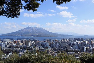
Kagoshima Prefecture is a prefecture of Japan located on the island of Kyushu and the Ryukyu Islands. Kagoshima Prefecture has a population of 1,564,175 and has a geographic area of 9,187 km2. Kagoshima Prefecture borders Kumamoto Prefecture to the north and Miyazaki Prefecture to the northeast.

<span class="mw-page-title-main">Kumamoto Prefecture</span> Prefecture of Japan

Kumamoto Prefecture is a prefecture of Japan located on the island of Kyūshū. Kumamoto Prefecture has a population of 1,748,134 and has a geographic area of 7,409 square kilometres (2,861 sq mi). Kumamoto Prefecture borders Fukuoka Prefecture to the north, Ōita Prefecture to the northeast, Miyazaki Prefecture to the southeast, and Kagoshima Prefecture to the south.

<span class="mw-page-title-main">Kushima, Miyazaki</span> City in Kyushu, Japan

Kushima is a city located in Miyazaki Prefecture, Japan. As of 1 November 2023, the city had an estimated population of 15,623 in 6950 households, and a population density of 53 persons per km². The total area of the city is 295.16 km2 (113.96 sq mi).

<span class="mw-page-title-main">Mimata, Miyazaki</span> Town in Kyushu, Japan

Mimata is a town located in Kitamorokata District, Miyazaki Prefecture, Japan. As of 1 November 2023, the town had an estimated population of 25,455 in 10394 households, and a population density of 230 persons per km2. The total area of the town is 110.02 km2 (42.48 sq mi). In October 2022, it was ranked as the best town to live in in Miyazaki Prefecture.

<span class="mw-page-title-main">Kadogawa, Miyazaki</span> Town in Kyushu, Japan

Kadogawa is a town located in Higashiusuki District, Miyazaki Prefecture, Japan. As of 1 October 2023, the town has an estimated population of 16,760 in 6887 households and a population density of 140 persons per km2. The total area of the town is 120.52 square kilometres (46.53 sq mi).

<span class="mw-page-title-main">Japan National Route 10</span> National highway in Japan

National Route 10 is a Japanese highway on the island of Kyushu. It originates at the intersection with Route 2 in Kitakyushu, Furoka and passes through the prefectural capitals of Ōita and Miyazaki, terminating at the intersection with Route 3 in Kagoshima. Route 10 follows the eastern coast along the Inland Sea and the Hyūga Sea. For much of its length, it parallels the JR Kyushu Nippō Main Line. Route 10 measures 454.8 km in length.

<span class="mw-page-title-main">Nippō Main Line</span> Railway line in Japan

The Nippō Main Line is a railway line in Kyushu, in southern Japan, operated by Kyushu Railway Company. Also known as the Fukuhoku Nippo Line, The line connects Kokura Station in Kitakyushu, Fukuoka, and Kagoshima Station in Kagoshima via the east coast of Kyushu, passing through the prefectural capitals of Ōita and Miyazaki. A number of Limited Express trains operate along the route, including Limited Express Sonic trains between Hakata and Oita.

<span class="mw-page-title-main">Miyakonojō</span> City in Kyushu, Japan

Miyakonojō is a city in Miyazaki Prefecture, Japan. As of 1 November 2023, the city had an estimated population of 158,235 in 72394 households, and a population density of 240 persons per km2. The total area of the city is 653.36 km2 (252.26 sq mi), making it the largest city in the prefecture in terms of area.

<span class="mw-page-title-main">Nobeoka</span> City in Kyushu, Japan

Nobeoka is a city located in the north of Miyazaki Prefecture, Japan. As of 1 October 2023, the city had an estimated population of 113,367 in 51272 households, and a population density of 130 persons per km². The total area of the city is 868.02 km2 (335.14 sq mi).

<span class="mw-page-title-main">Nobeoka Station</span> Railway station in Nobeoka, Miyazaki Prefecture, Japan

Nobeoka Station is a railway station in the city of Nobeoka, Miyazaki, Japan. It is operated by JR Kyushu, and is the main station for the city. It is also a freight depot for JR Freight.

<span class="mw-page-title-main">Mimata Station</span> Railway station in Mimata, Miyazaki Prefecture, Japan

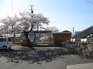
Mimata Station is a passenger railway station located in the town of Mimata, Miyazaki, Japan. It is operated by JR Kyushu and is on the Nippō Main Line.

<span class="mw-page-title-main">Sosanji Station</span> Railway station in Miyazaki, Miyazaki Prefecture, Japan

Sosanji Station is a passenger railway station located in the city of Miyazaki City, Miyazaki Prefecture, Japan. It is operated by JR Kyushu and is on the Nichinan Line.

<span class="mw-page-title-main">Hyūga-Ōtsuka Station</span> Railway station in Kushima, Miyazaki Prefecture, Japan

Hyūga-Ōtsuka Station is a passenger railway station located in the city of Kushima, Miyazaki Prefecture, Japan. It is operated by JR Kyushu.

<span class="mw-page-title-main">Hyūga-Kitakata Station</span> Railway station in Kushima, Miyazaki Prefecture, Japan

Hyūga-Kitakata Station is a passenger railway station located in the city of Kushima, Miyazaki Prefecture, Japan. It is operated by JR Kyushu.

<span class="mw-page-title-main">Totoro Station</span> Railway station in Nobeoka, Miyazaki Prefecture, Japan

Totoro Station is a passenger railway station located in the city of Nobeoka, Miyazaki, Japan. It is operated by JR Kyushu and is on the Nippō Main Line.

<span class="mw-page-title-main">Hyūga-Nagai Station</span> Railway station in Nobeoka, Miyazaki Prefecture, Japan

Hyūga-Nagai Station is a passenger railway station in the city of Nobeoka, Miyazaki, Japan. It is operated by JR Kyushu and is on the Nippō Main Line.

<span class="mw-page-title-main">Hyūga Maeda Station</span> Railway station in Miyakonojō, Miyazaki Prefecture, Japan

Hyūga Maeda Station is a passenger railway station located in the city of Miyakonojō, Miyazaki Prefecture, Japan. It is operated by JR Kyushu.

<span class="mw-page-title-main">Hyūga Shōnai Station</span> Railway station in Miyakonojō, Miyazaki Prefecture, Japan

Hyūga Shōnai Station is a passenger railway station located in the city of Miyakonojō, Miyazaki Prefecture, Japan. It is operated by JR Kyushu.

<span class="mw-page-title-main">Sobo-Katamuki Quasi-National Park</span>

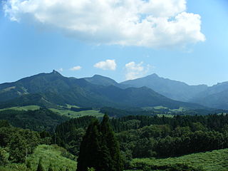
Sobo-Katamuki Quasi-National Park was a Quasi-National Park in Ōita and Miyazaki Prefectures, Japan. It was in 2017 incorporated in to the Sobo, Katamuki and Okue Biosphere Reserve.

<span class="mw-page-title-main">Nippō Kaigan Quasi-National Park</span> National Park in Japan

Nippō Kaigan Quasi-National Park is a Quasi-National Park on the coast of Ōita and Miyazaki Prefectures, Japan. It was established in 1974.

References

Video Footage

The following travel- and tourism-related videos were shot and provided by video artist egawauemon.

32°1′N131°21′E / 32.017°N 131.350°E / 32.017; 131.350