Humans have inhabited the prefecture for at least 15,000 years, and the oldest evidence of pottery in Japan was discovered at the Jōmon periodŌdai Yamamoto I Site. After centuries of rule by the Nanbu and Tsugaru clans, the prefecture was formed out of the northern part of Mutsu Province during the Meiji Restoration in the 19th century. The entire Tōhoku region, including Aomori Prefecture, experienced significant growth in population and economy until the late 20th century, when a significant population decline began. Though the prefecture remains dominated by primary sector industries, especially apple orchards, it also serves as a transportation and logistics hub due to its location. Additionally, it is the largest producer of black garlic in Japan. Tourism is also a significant part of the prefecture's economy, especially due to the Jōmon Prehistoric Sites in Northern Japan and Shirakami-SanchiWorld Heritage Sites.
Aomori Prefecture has a distinctive subculture influenced by its distant location relative to the central government of Japan and the region's long, snowy winters. It is the birthplace of the traditional Tsugaru-jamisen, a local version of the three-stringed musical instrument known as shamisen. Embroidery, pottery, lacquerware, cabinetry, and iron working are also significant crafts in the prefecture. Various porridges and soups are distinctive to Aomori. Several festivals are held in Aomori Prefecture; the most noted of which is Aomori Nebuta Matsuri. Aomori Prefecture is home to several association football, baseball, basketball, and ice hockey teams. The prefecture's religious beliefs are heavily rooted in Shinto and Buddhism; it is noted for its blind mediums and alleged tomb of Jesus.
Aomori (青森) literally means 'blue forest', although it could possibly be translated as 'green forest'. The name most likely refers to a small forest on a hill which existed near Aomori City, which was often used by fishermen as a landmark.[3][4][5]
Jōmon period
The Jōmon period is the time between c.14,000 and 300 BCE, during which Japan was inhabited by the Jōmon people, a diverse hunter-gatherer and early agriculturalist population.[6][7][8] The oldest evidence of pottery in Japan was found at the Ōdai Yamamoto I Site in the town of Sotogahama in the northwestern part of the prefecture. The relics found there suggest that the Jōmon period began about 15,000 years ago.[9] By 7,000 BCE, fishing cultures had developed along the shores of the prefecture.[10] Around 3,900 BCE, settlement at the Sannai-Maruyama Site in the present-day city of Aomori began.[11] The settlement shows evidence of wide interaction between the site's inhabitants and people from across Jōmon period Japan, including Hokkaido and Kyushu.[9] The settlement of Sannai-Maruyama ended around 2,300 BCE for unknown reasons. Its abandonment was likely due to the population's subsistence economy being unable to result in sustained growth, with its end being spurred on by the reduced amount of natural resources during a neoglaciation.[12] The Jōmon period continued up to 300 BCE in present-day Aomori Prefecture at the Kamegaoka site in the city of Tsugaru where small statuettes called Shakōkidogū have been found.[9]
The Yayoi period, c.300 BCE– c.300 AD, is one of the major historical periods of the Japanese archipelago. It is generally defined as the era between the beginning of food production in Japan and the emergence of keyhole-shaped burial mounds.[13][14] During this time, the area that would become Aomori Prefecture was impacted by the migration of settlers from continental Asia, though to a lesser extent than the rest of Honshu. The region, known then as Michinoku, was inhabited by the Emishi. It is not clear if the Emishi were the descendants of the Jōmon people, a group of the Ainu people, or if both the Ainu and Emishi were descended from the Jōmon people. The northernmost tribe of the Emishi that inhabited what would become Aomori Prefecture was known as the Tsugaru.[15] Historic records mention a series of destructive eruptions in 917 from the volcano at Lake Towada. The eruptive activity peaked on August 17.[16] The Heian period, c.794 and 1185, was characterized by centralized government influenced by China.[17] Throughout this period, the Emishi were slowly subdued by the Imperial Court in Kyoto before being incorporated into Mutsu Province by the Northern Fujiwara around 1094.[18] The Northern Fujiwara continued to rule the Tōhoku region until 1189.[19] Mutsu Province was a large province that was later broken into Fukushima, Miyagi, Iwate, and Aomori Prefectures and the municipalities of Kazuno and Kosaka in Akita Prefecture.[20][21][22]
The Northern Fujiwara set up the port settlement of Tosaminato in present-day Goshogawara to develop trade between their lands, Kyoto, and continental Asia.[23] The Northern Fujiwara were deposed in 1189 by Minamoto no Yoritomo, who would go on to establish the Kamakura shogunate, which is known for the emergence of the samurai, the warrior caste, and for the establishment of feudalism in Japan.[24][25]
Kamakura period
The Kamakura period is a phase that marks the governance by the Kamakura shogunate between c.1185 and 1333. Minamoto no Yoritomo incorporated Mutsu Province into the holdings of the Kamakura shogunate.[26] Nanbu Mitsuyuki, founder of the Nanbu clan,[27][28][29][30] was awarded vast estates in Nukanobu District after he had joined Minamoto no Yoritomo at the Battle of Ishibashiyama in 1180 and the conquest of the Northern Fujiwara.
Nanbu Mitsuyuki built Shōjujidate Castle in what is now Nanbu, Aomori.[31] The eastern area of the current prefecture was dominated by horse ranches, and the Nanbu grew powerful and wealthy on the supply of warhorses. These horse ranches were fortified stockades, numbered one through nine (Ichinohe through Kunohe), and were awarded to the six sons of Nanbu Mitsuyuki, forming the six main branches of the Nanbu clan.[27][28][29][30] The northwestern part of the prefecture was awarded to the Andō clan for their role in driving the Northern Fujiwara out of Tosaminato. The port was expanded under the rule of the Andō clan and they traded heavily with the Ainu in Ezo. Conflict would break out between the Ainu and the Andō clan in 1268 and again in the 1320s. The conflict ended after the Nanbu intervened at the behest of the shogunate. The conflict weakened the Kamakura shogunate in its later years. The Andō became split into northern (Andō) and southern (Akita) divisions.[32]
Muromachi period
The remains of Horikoshi Castle
The Muromachi period, c.1336– c.1573, saw the rise of the Muromachi or Ashikaga shogunate and Onmyōji, practitioners of astronomy and divination, into high governmental positions.[33] At the onset of the Ashikaga shogunate, the Nanbu and Andō continued to rule the area, with the Nanbu controlling the current prefecture's southeastern section and the Andō controlling the Shimokita and Tsugaru peninsulas. The Andō also were involved with controlling the fringes of Ezo, splitting their attention. In 1336, the Andō completed construction of Horikoshi Castle during the Northern and Southern Courts period.[34] During the Muromachi, the Nanbu slowly began edging the Andō out of present-day Aomori Prefecture. The Andō were pushed out of Tosaminato in 1432, retreating to Ezo, giving the Nanbu control over all their lands. The port settlement would fall into disrepair under the Nanbu.[23]
Sengoku period
The Sengoku period of the 15th and 16th centuries is an era in which civil wars and social upheavals took place almost continuously, similar to the Dark Ages in Europe.[35] During the Sengoku period, the Nanbu clan collapsed into several rival factions. One faction under Ōura Tamenobu asserted their control over the Hirosaki Domain. His clan, originally the Ōura clan (大浦氏, Ōura-shi), was of uncertain origins. According to later Tsugaru clan records, the clan was descended from the noble Fujiwara clan and had an accent claim to ownership of the Tsugaru region on the Tsugaru Peninsula and the area surrounding Mount Iwaki in the northwestern corner of Mutsu Province; however, according to the records of their rivals, the Nanbu clan, clan progenitor Ōura Tamenobu was born as either Nanbu Tamenobu or Kuji Tamenobu, from a minor branch house of the Nanbu and was driven from the clan due to discord with his elder brother.[36]
In any event, the Ōura were hereditary vice-district magistrates (郡代補佐, gundai hosa) under the Nanbu clan's local magistrate Ishikawa Takanobu; however, in 1571, Tamenobu attacked and killed Ishikawa and began taking the Nanbu clan's castles in the Tsugaru region.[37] He captured castles at Ishikawa, Daikoji and Aburakawa, and soon gathered support of many former Nanbu retainers in the region. After pledging fealty to Toyotomi Hideyoshi, he was confirmed as an independent warlord in 1590 and changed his name to "Tsugaru", formally establishing the Tsugaru clan. Tsugaru Tamenobu assisted Hideyoshi at the Battle of Odawara, and accompanied his retinue to Hizen during the Korean Expedition. Afterwards, he sided with Tokugawa Ieyasu during the Battle of Sekigahara in 1600.[38]
During the Edo period, c.1600– c.1868, Japan was under the rule of the Tokugawa shogunate and some 300 regional daimyo, or feudal lords. The Edo period was a prolonged era of peace, stability, economic expansion, and urbanizaion.[39] After the establishment of the Tokugawa Shogunate, the Nanbu ruled the Shimokita Peninsula and the districts immediately to the south of it. The area to the west of the Nanbu's holdings and to the north of the lands held by the Akita clan were all controlled by the Tsugaru clan, from their capital at Hirosaki. Work on Hirosaki Castle was completed in 1611, replacing Horikoshi Castle as the Tsugaru clan's fortress.[34] By 1631, the Tsugaru clan had solidified their control over their gains made during the Sengoku period.[40] Mutsu Province was struck by the Tenmei famine between 1781 and 1789, due to lower than usual temperatures that were exacerbated by volcanic eruptions at Mount Iwaki, near the Tsugaru clan's capital, Hirosaki, between November 1782 and June 1783.[41]
At the beginning of the Edo period, the last pockets of Ainu people in Honshu still lived in the mountainous areas on the peninsulas of the prefecture. They interacted with the ruling clans to some extent, but they primarily lived off of fishing the waters of Mutsu Bay and the Tsugaru Strait. The Tsugaru clan made two big pushes to assimilate the Ainu; the first came in 1756 and the second came in 1809. Records show that the clan was successful in wiping out the Ainu culture in their holdings, though some geographic names in Aomori Prefecture still retain their original Ainu names.[42]
Meiji Restoration to World War II
Memorial to the Battle of Noheji
The Meiji Restoration in 1868 restored imperial rule to Japan, with Emperor Meiji assuming the throne.[43] Despite the 1867 resignation of the last shogun, Tokugawa Yoshinobu, the Boshin War had reached northern Japan by late 1868. On September 20, 1868 the pro-Shōgunate Ōuetsu Reppan Dōmei was proclaimed at Morioka, the capital of the Nanbu clan who ruled Morioka Domain. The Tsugaru clan first sided with the pro-imperial forces of Satchō Alliance, and attacked nearby Shōnai Domain.[44][45] The Tsugaru soon switched course, and briefly became a member of the Ōuetsu Reppan Dōmei.[46] For reasons unclear, the Tsugaru backed out of the alliance and re-joined the imperial cause after a few months. The Nanbu and Tsugaru clans resumed their old rivalry and fought at the Battle of Noheji.[44]
As a result of the minor skirmish, the Tsugaru clan was able to prove its defection from the Ōuetsu Reppan Dōmei and loyalty to the imperial cause. Tsugaru forces later joined the imperial army in attacking the Republic of Ezo at the Battle of Hakodate, where the pro-Shōgunate forces were finally defeated.[47] As a result, the entire clan was able to evade the punitive measures taken by the Meiji government on other northern domains.[48]
In 1868, Mutsu Province was broken up into five provinces in the aftermath of the Boshin War, with a new province, Rikuō, occupying what would later become Aomori Prefecture and the northwestern corner of Iwate Prefecture.[21] On September 4, 1871, Rikuō Province was abolished and divided, establishing today's Aomori Prefecture. Its capital was briefly located in Hirosaki, but it was moved on September to 23, 1871 to the centrally located port village, Aomori.[20]
The prefecture's new capital, Aomori, saw rapid expansion due to its importance as a logistic hub in northern Japan.[49] It became a town in 1889 and then a city in 1898. The Nippon Railway, a private company, completed the Tōhoku Main Line in 1891, linking Aomori to Ueno Station in Tokyo.[50] Despite problems with harsh winters and little previous urban development, this accomplishment was crucial to the rapid population and economic development of the prefecture after the Meiji Restoration.[51][52][53][54]
Cheseborough Memorial in Shariki Village
On October 30, 1889, an American merchant ship, Cheseborough, was wrecked off the prefecture's west coast near the village Shariki; many of the ship's crew were saved by the villagers.[55] During a military exercise on January 23, 1902, 199 soldiers died after getting lost during a blizzard in the Hakkōda Mountains disaster.[56] On May 3, 1910, a fire broke out in the Yasukata district[ja]. Fanned by strong winds, the fire quickly devastated the whole city. The conflagration claimed 26 lives and injured a further 160 residents. It destroyed 5,246 houses and burnt 19 storage sheds and 157 warehouses.[57]Sabishiro Beach, Misawa was the departure point for Clyde Pangborn and Hugh Herndon when they began the first successful nonstop trans-Pacific flight on October 4, 1931. They landed in East Wenatchee, Washington a little over 41 hours later.[58][59]
Throughout much of World War II, the conflict remained distant for the people of Aomori Prefecture. Its ports and railways served to connect Hokkaido to the rest of Japan, chiefly bringing coal from the north to production sites in Japan's more populous areas. This connectivity became a strategic target for the American forces as the war neared its conclusion.[60] At 10:30 p.m. on July 28, 1945, a squadron of American B-29 bombersbombed over 90 percent of the city of Aomori. Despite prior warnings, the estimated civilian impact of the air raid on the city was significant,[61] partly because of threats by the prefecture's governor to cut food rations for those who fled the city.[62] Infrastructure was destroyed across the prefecture including the Seikan Ferry, naval facilities in Mutsu and Misawa, Hachinohe Airfield, and the ports and railways of Aomori and Hachinohe.[63][64][65]
1945 to present
During the occupation of Japan, Aomori's military bases were controlled by the US military. Hachinohe Airfield was occupied until 1950, and was called Camp Haugen.[66]Misawa Air Base was occupied and rebuilt by the United States Army Air Forces; the base has seen a US military presence since then.[67][68]
The occupation government began an extensive Land Reclamation Policy (LRP) in 1946 aimed at reintegrating the seven million repatriates from Japan's former Asian colonies. This resulted in 269 new villages and 29,612 households on approximately 24,400 hectares (60,000 acres) of land in Aomori Prefecture.[69]
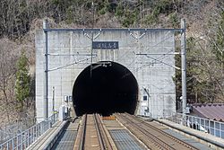
Entrance to Seikan Tunnel from Honshu side; note the dual-gauge tracks
In March 1985, after 23 years of labor and a financial investment of 690billion yen, the Seikan Tunnel finally linked the islands of Honshū and Hokkaido, thereby becoming the longest tunnel of its kind in the world.[70] Almost exactly three years later, on March 13, railroad service was inaugurated on the Tsugaru Kaikyo Line. The tunnel's opening to rail traffic saw the end of the Seikan Ferry rail service. During their 80 years of service, the Seikan rail ferries sailed between Aomori and Hakodate some 720,000 times, carrying 160million passengers. Ferry service continues to operate between the cities, ferrying automobile traffic and passengers rather than trains.[71][72][73]
On June 2, 2007, four North Korean defectors reached Aomori Prefecture, after having been at sea for six days, marking the second known case ever where North Korean defectors have successfully reached Japan by boat.[74] This was a family of four, two parents with two adult sons, who made the journey in an open wooden boat and were picked up by the Japan Coast Guard and taken to the port of Fukaura. After being in an immigration center in Ibaraki Prefecture, they were flown from Tokyo to South Korea's Incheon International Airport at their own request.[75][76]
On March 11, 2011, a magnitude 9.0 earthquake struck the east coast of Japan. The southeastern coast of Aomori Prefecture was affected by the resulting tsunami. Within Aomori Prefecture, three people died and one was missing.[77] Buildings along harbors were damaged, with boats thrown about in the streets.[78][79] Disruptions as result of the earthquake to road and rail networks were widespread throughout the prefecture in the days following the earthquake.[80] The Tōhoku Shinkansen rail line was significantly damaged, cutting connectivity from the prefecture to points south along the line until full service was restored in late September.[81]
In January 2025, a record setting disaster-level snowfall hit Aomori Prefecture, with snow depths as much as 3.74 meters (12.3ft). Sōichirō Miyashita, the provincial governor, called this snowfall a "disaster" and invoked the Disaster Relief Act, the first time the prefecture had done so in 13 years. At least 4 people died as a result of the snowfall.[82][83] This snowfall did massive damage to the prefecture's important apple harvest, causing an estimated ¥10 billion (US$64.8 million) in damage to the crop. Many apple trees had their trunks and branches broken.[84]
Geography
Aomori Prefecture and the surrounding area as seen from spaceTsugaru Railway in Ashino Chishōgun Prefectural Natural Park
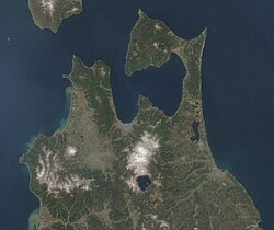
Aomori Prefecture is the northernmost prefecture in the Tōhoku region,[85] lying on the northern end of the island of Honshu. It faces Hokkaido from across the Tsugaru Strait and it borders Akita and Iwate in the south. The prefecture is flanked by the Pacific Ocean to the east and the Sea of Japan to the west with the Tsugaru Strait linking those bodies of water to the north of the prefecture. The islets of Kyūroku-jima in the Sea of Japan are the prefecture's westernmost point.[86]Oma, at the northwestern tip of the axe-shaped Shimokita Peninsula, is the northernmost point of Honshu. The Shimokita and Tsugaru Peninsulas enclose Mutsu Bay. Between those peninsulas lies the smaller Natsudomari Peninsula, the northern end of the Ōu Mountains. The three peninsulas are prominently visible in the prefecture's symbol, a stylized map.[87] Aomori Prefecture is the 8th-largest prefecture, with an area of 9,645.64km2 (3,724.20sqmi), and the 31st-most populous prefecture, with more than 1.18million people.[88]Mount Iwaki, an active stratovolcano, is the prefecture's highest point, at almost 1,624.7m (5,330ft).[89][90]
Lake Ogawara lies at the base of the Shimokita Peninsula. It is the prefecture's largest lake and the eleventh largest in Japan. It is also the largest brackish lake in the Tōhoku area.[91]Lake Towada sits in a volcanic caldera, straddles Aomori's boundary with Akita. It is a primary feature of Towada-Hachimantai National Park and is Honshu's largest caldera lake.[92] Also within the park, the Oirase River flows east towards the Pacific Ocean from Lake Towada. Another feature of the park, the Hakkōda Mountains, an expansive volcanic group, rises in the lands to the south of the city of Aomori and north of Lake Towada.[87]
Shirakami-Sanchi, a UNESCO World Heritage Site, is located in the Shirakami Mountains in the western part of the prefecture. The site contains the largest surviving virgin beech forest in East Asia, which is home to over 87 species of birds.[93][94] Mount Iwaki, a stratovolcano and the prefecture's highest point lies to northeast of the Shirakami Mountains. The lands to the east and northeast of Mount Iwaki are an expansive floodplain that is drained by the Iwaki River. Hirosaki, the former capital of the Tsugaru clan, sits on the banks of the river.[87]
Aomori Prefecture has four distinct seasons, with an average annual temperature of 10°C (50°F). Variations in climate exist between the eastern (Pacific Ocean) and the western (Sea of Japan) parts of the prefecture. This is in part due to the Ōu Mountains that run north to south in the middle of the prefecture, dividing the two regions. The western side is subject to heavy monsoons and receives little sunshine; it experiences heavy snowfall during the winter. The eastern side is subject to low clouds brought in by northeasterly winds during the summer months, known locally as Yamase winds, from June through August, with temperatures staying relatively low. There are instances of Yamase winds making summers so cold that food production is hindered. The lowest recorded temperature during the winter is −9.3°C (15.3°F), and the highest recorded temperature during the summer is 33.1°C (91.6°F).[87][109] The city of Aomori and the surrounding areas are known for having the heaviest snowfall in the world.[110] In 2016, AccuWeather ranked Aomori as the snowiest city in the world.[111]
Temperature comparison
Monthly average highs and lows for various cities and towns in Aomori Prefecture in Fahrenheit and Celsius
A person living in or from Aomori Prefecture is referred to as an Aomorian in English.[128][129][130] As of 2017, the prefecture had a total population of 1.28million residents, accounting for just over 1 percent of Japan's total population.[131] Approximately 45 percent of Aomori Prefecture's residents live in its two core cities, Aomori and Hachinohe, on its coastal plains.[108] The majority of the prefecture is covered in forested mountain ranges, with population centers occupying valleys and plains.[132] Aomori is the third-most populous prefecture in the Tōhoku region, after Miyagi Prefecture and Fukushima Prefecture.[108]
Aomori Prefecture's population grew until the late 20th century.[108][127] Japan's population growth rate started declining in 1970 and the total population peaked in 2010 at 128 million.[133] Aomori Prefecture has the 5th highest percentage of population of seniors among all prefectures at 34.8 percent. This percentage is expected to be 46.8 percent by 2045, resulting in the prefecture having the second highest rate above age 65 by then. The total population is expected to fall by 35 percent by 2050.[133] Exacerbating this problem is the prefecture's declining total fertility rate (TFR). In 1925, the prefecture's TFR was 6.25, but by 2008 it had fallen to 1.21.[134] In 2022, the prefecture's birth rate was 1.24, the lowest in its recorded history.[135]
In 2018, Aomori Prefecture saw the second largest decrease in the number of Japanese citizens out of any prefecture in the country. Only neighboring Akita Prefecture lost more citizens than Aomori.[136] In July 2025 the "Aomori Declaration" was issued by a meeting held in Aomori City of the National Governors' Association to address Japan's declining population, describing it as "the biggest challenge" facing the country.[137] In 2017, 23,529 people moved out of Aomori, while 17,454 people moved to the prefecture.
[131] In 2018, about 590,000 of the prefecture's residents were men and 670,000 were women, 10.8 percent of the population was below the age of 15, 56.6 percent of residents were between the ages of 15 and 64, and 32.6 percent was above the age of 64.[135] In the same year the prefecture had a density of 130.9 people per square kilometer.Japan is noted for long lifespans, however Aomori Prefecture has the lowest male and female life expectancy of the whole country, for which high salt consumption and low physical activity are factors.[138]
In 2020, Aomori the fifth lowest ratio of foreign immigrants of all Japan's prefectures.[139] Scholars suggest that immigration is not expected to reverse the prefecture's population decline, as immigration to Japan is limited.[133][140] In 2007, Aomori Prefecture had the 7th lowest number of international marriages among all of Japan's prefectures, with only 664 marriages where one of the spouses was a foreigner.[141]
Like much of the Tōhoku Region, Aomori Prefecture remains dominated by primary sector industries, such as farming, forestry and fishing. The prefecture's forestry industry is centered around the cultivation and harvesting of hiba, a cypress tree utilized in construction of wooden structures across the country.[142] In 2015, its economy had a GDP of 4,541.2billion yen, which represented about 0.83 percent of Japan's economy.[131] Aomori Prefecture generates the largest amount of wind energy out of the prefectures of Japan, with large wind farms located on the Shimokita Peninsula and Tsugaru.[143][144] The peninsula is also home to the inactive Rokkasho Reprocessing Plant that is owned by Japan Nuclear Fuel Limited, a company headquartered in the village of Rokkasho that is involved in the production of nuclear fuel, as well as the reprocessing, storage, and disposal of nuclear waste.[145] In July 2024, the governor of Aomori announced the approval of a nuclear waste storage facility in town of Mutsu.[146] The city of Hachinohe is home to the Pacific Metals Company, a manufacturer of ferronickel products.[87]
Agriculture
Farmland in Aomori
Aomori Prefecture is a leading agricultural region in Japan. It is Japan's largest producer of apples, growing about 60 percent of Japan's total apple production, producing 50 million tons yearly.[147][148][149] The cultivation of apples in the prefecture began in 1875 when the prefecture was given three varieties of Western origin to grow. Most imported apple trees came from the France and United States.[150] The apples are consumed within Japan and exported to the United States, China, Taiwan, and Thailand.[87] Aomori is also ranked highly in the nation's production of redcurrant, burdock, and garlic,[151] accounting for 81, 37, and 66 percent, respectively, of the country's production.[147]Climate change is having a negative impact on agriculture in Aomori Prefecture, especially on apples and other fruits.[152]
Aomori is also the center of Hakkōda cattle rearing, a rare, region-specific breed of Japanese Shorthorn.[153] The town of Gonohe has a long history as a breeding center for horses, popular among the samurai. With the decline of the samurai, Gonohe's horses continued to be bred for their meat. The lean horse meat is coveted as a delicacy, especially when served in its raw form, known as basashi (馬刺し). The Aomori coast along Mutsu Bay is a large source of scallops; they are particularly a specialty of the town Hiranai, where the calm water around Natsudomari Peninsula makes a good home for them.[154]
Tourism has been a growing sector of Aomori Prefecture's economy. It was among the top five prefectures of Japan in terms of growth in foreign tourists between 2012 and 2017.[156] This influx of foreign tourists has led to the construction of more hotels in Aomori.[156] Major draws to the prefecture are its historic sites,[157] museums, and national parks. Several of the prefecture's Jōmon period historic sites were nominated in January 2009 to become UNESCO World Heritage Sites and were placed on the World Heritage Tentative List.[158] On July 27, 2021 the other Jōmon sites, totaling 17 sites, in neighboring prefectures were placed on the World Heritage Site list.[158][159] These sites were the second sites in Aomori Prefecture placed on the list. The first was Shirakami-Sanchi, an area of virgin forests. Tourist access to Shirakami-Sanchi is heavily restricted due to its delicate ecosystem, though several water features, trails, and roads can be accessed by its visitors.[160][161] About 35.2million domestic travelers visited Aomori Prefecture in 2016, while about 95,000 foreign tourists visited in 2017.[131]
Military
Aomori Prefecture and the Tsugaru Strait are of strategic value to both Japan and the United States, as the strait serves as an access point for the United States Navy into the Sea of Japan where they can put pressure on Russia, China, and North Korea.[162] The prefecture also hosts Misawa Air Base, the only combined, joint U.S. service installation in the western Pacific servicing Army, Navy, Marine Corps, Space Force, and Air Force, as well as the Japan Self-Defense Forces.[163]
Culture
Traditional crafts
Kogin-zashi pattern examples
The Tsugaru region of Aomori Prefecture is the birthplace of the traditional Tsugaru-jamisen, a local style of music played on the shamisen (a three–stringed musical instrument). A notable player of the style was Takahashi Chikuzan, a blind musician from Hiranai, who wandered around the country and eventually gained nationwide appeal.[164][165] Aomori Prefecture is also where the decorative embroidery styles, kogin-zashi and Nanbu hishizashi originated, as more utilitarian textile techniques during the Edo period. The peasant women of the area, who created the styles, used them to make linen clothing more robust and warm during the harsh winters since cotton was unavailable to the lower class.[166][167][168] Wooden horse figures called Yawata-uma (also Hachinohe horse) have been made in the former holdings of the Nanbu for 700 years.[169][170] Hachinohe horses are often given at celebrations as they are believed to bring good luck.[170][171] Other crafts native to Aomori Prefecture include pottery, lacquerware, cabinetry, and iron working.[172][173] The type of lacquerware specific to Aomori is known as Tsugaru-Nuri.[174]
Cuisine
Ke porridge
The Aomori area has given rise to several soups: ke porridge or Keno-jiru, which consists of miso soup with diced root vegetables and wild plants such as butterbur and bracken with tofu from the Tsugaru area; ichigoni, a sea urchin roe and abalone soup in which the sea urchin roe looks like strawberries, known as ichigo in Japanese, from the town of Hashikami; hittsumi a roux with chicken and vegetables from the Nanbu area; Hachinohe senbei soup a hearty soup with Nanbu senbei loaded with vegetables and chicken; jappa-jiru a vegetable soup with cod roe from Aomori; and keiran a red bean dumpling soy sauce soup served during special occasions on the Shimokita Peninsula. Another dish that was created in the area surrounding Mutsu Bay is kaiya in the Tsugaru area or kayaki on the Shimokita Peninsula, it is a boiled miso and egg dish mixed with fish or scallop meat on a large scallop shell that serves as both the cookware and dishes.[175] In 2006, the production of aged black garlic began in Aomori Prefecture. The prefecture has since become the largest producer of black garlic in Japan.[176]
Aomori Prefecture hosts the Aomori Nebuta Matsuri, one of the Three Great Festivals of Tōhoku[ja]. The other two Great Festivals are Akita Kanto and the Sendai Tanabata, which are held elsewhere in Tōhoku.[177] During late April, hanami festivals are held across the prefecture, with the most prominent being located on the grounds of Hirosaki Castle.[178][179] Many unique festivals are held during summer with bright lights, floats, dancing and music; including Aomori Nebuta Matsuri as well as several other iterations of the festival throughout the towns and cities of the prefecture.[180][181] Winter is centered on snow festivals where attendees can view ice sculptures and eat local cuisine inside ice huts.[182][183] Tsugaru's festivals tie in to its past and are more rural and community in nature than religious; eventhough they mix Shinto and Buddhist practices as well as music and dance.[184]
Japanese religious beliefs are very syncretic,[192] known as Shinbutsu-shūgō. About 95 percent of the populations is either Buddhist or Shinto. The formal separation of those two religions did not occur until the late 19th century and is known as Shinbutsu bunri.[193] This began occurring during the Meiji Restoration when a series of laws began to be passed. There is no agreement as to the degree of melding of the two religions.[194]Christianity comprises about 1-2 percent of the population of Japan.[195] The Christian population is concentrated mostly in Tokyo and western Japan.[196] In Aomori, Christians are less than 1 percent of the population.[197]
The Takayama Inari Shrine is a Shinto shrine located in Tsugaru. People come here to offer prayers on behalf of business prosperity, plentiful harvests, and maritime safety. There is a memorial with a Christian cross dedicated to American sailors who died when the Cheseborough ran aground in a typhoon at Shariki, Aomori in 1889.[198][199]
Mount Osore, located on the Shimokita Peninsula of the prefecture, is covered with a barren landscape, jagged rock formations, and smells of sulfuric gases. It is considered a gateway to the underworld in some belief systems. The Bodai-ji Temple is located here and it specializes in taking care of the dead and is the traditional home to the itako blind mediums who connect with the dead.[200][201]
Blind mediums
An itako at the autumn Inako Taisai festival at Mount Osore, Aomori Prefecture
Itako, also known as ichiko or ogamisama, are blind women who train to become spiritual mediums in Japan.[202] They are strongly associated with Aomori Prefecture and today they are most commonly associated with the Mt. Osore area of the prefecture. Itako have traditionally gathered there for an annual festival to channel the dead.[203]Itako perform ceremonies to communicate with spirits of the recently deceased,[204] including those of aborted and stillborn children.[205]
The tradition of itako arose because in earlier times the prefecture had very poor nutrition and sanitation, causing many children to go blind. In order for these children to be able to make a living, the females were trained as itako and the males for professions such as acupuncture, massage, moxibustion, and playing shamisen.[205][206] Blindness has long been associated with spiritual powers in Japan.[206][207]
Itako training traditionally began at a very young age, and included ritualized exposure to cold water. Hundreds of buckets of ice water could be poured on their bodies over the course of a few days.[204] This education for itako takes about three years, and also includes memorization of songs and sutras.[208] This training involves severe ascetic practices, after which the woman is said to be able to communicate with Japanese Shinto spirits, kami, and the spirits of the dead.[204] At the end of this training, a ceremony is held, announcing the marriage of the itako and her patron spirit.[209]Itako perform rituals tied to communication with the dead and divination.[204][210] In the 1950s to 1970s there were still dozens of itako in the prefecture.[206] The practice has been on the decline since then. As of 2009, there were only 20 living itako in Japan, all more than 40 years old.[202]
Purportedly ancient documents were published in 1935, claiming Jesus preached and died at age 106 in Shingō village in Aomori Prefecture.[a] The documents, known as the "Takeuchi manuscript" or "Takeuchi documents",[212] claim Jesus did not die on the cross, but rather his brother did and Jesus made his way to Aomori via Siberia. Jesus then married a young woman named Miyuko and fathered three daughters.[213] During this time he trained for 12 years and then began to spread Christianity. His alleged grave is in Shingō and 20,000-30,000 thousand visitors see it every year. In June 1964 an annual festival began being held at the gravesite.[211][212][214] Jesus' eldest alleged daughter married into the Sawaguchi family and there are still members of that family who claim non-Asian physical characteristics and lineage from Jesus.[213]
Landmarks
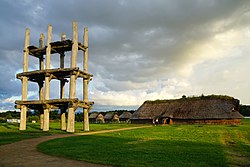
Reconstructed six-pillar structure and long pit-dwelling at Sannai-Maruyama Site
Hirosaki Castle was the seat of the Tsugaru clan; it was constructed in 1611. It is the only castle in the Tōhoku region from the Edo period that is still standing and is located in the western part of the prefecture. Festivals held on the grounds of Hirosaki Castle include the Cherry Blossom Festival and Snow Lantern Festival.[179][215]
The Aomori Museum of Art is located near the Sannai-Maruyama Site,[223] which inspired the museum's partially buried structure.[224] It opened in 2006 focusing on highlighting the arts of northern Tōhoku. An 8.5-meter (28ft) tall concrete sculpture of a dog has become the museum's symbol.[225][226] The museum has helped increase tourism in the area and is most noted for its collection of Marc Chagall's backdrops for the play Aleko.[223] The Towada Art Center is a set of geometric structures designed by SANAA and opened in 2008 in an effort to revitalize downtown Towada. It focuses on art that blends city structures and nature. Some of the works it holds are by Ron Mueck and Yoko Ono.[227]
The Aomori Prefecture Tourist Center, also known as Aomori Prefecture Tourism Information Center (ASPAM: "Aomori", "Sightseeing", "Products", "Mansion".), is large triangle shaped building built in 1986 in Aomori City used to promote tourism in the prefecture. It has a 360-degree panoramic movie theater, a Kogin-zashi embroidery demonstration, apple sales, and an observatory.[228]
Numbered map of Aomori Prefecture single-member districts
Aomori Prefecture's head of government is a governor, with the seat of the prefectural government in the city of Aomori.[247] There are 48 members in the Aomori Prefectural Assembly, which is unicameral. Members are elected to four-year terms.[248] In terms of national politics, the prefecture has three single-member districts: Aomori 1st district, Aomori 2nd district, Aomori 3rd district, each a constituency of the House of Representatives in the national Diet of Japan.[88][249] In addition, the prefecture has two members elected from the Aomori at-large district to the House of Councillors in the Diet. The at-large members are elected to six-year terms in staggered elections every three years.[250][251]
The Aomori Prefecture Board of Education oversees various aspects of the prefecture's educational system including the management of libraries, the Aomori Prefectural Museum, and various educational support offices and centers. In all, the prefecture allocated 130.3 billion yen towards education in 2018. In 2017 the prefecture's public school system was teaching 133,507 primary and secondary students, a sharp decrease from a total of 173,537 students ten years earlier. Overall the prefecture has 94 kindergartens (1 of which is a national school and 3 that are public), 289 elementary schools (1 of which is a national school and 288 that are run by municipal governments), 161 middle schools (1 of which is a national school, another which is run by the prefecture, 4 that are private, and 155 that are run by municipal governments), and 95 high schools.[260]
Aomori Prefecture has 20,818.1km (12,935.8mi) of roads, highways, and streets, along with 229km (142mi) of expressways.[261] Four major expressways pass through the prefecture: the Tōhoku Expressway, which runs south–north through center of the prefecture; the incomplete Tsugaru Expressway, running east–west in the southwestern portion of the prefecture; the partially-complete Hachinohe-Kuji Expressway that travels south–north along the prefecture's eastern coast to Hachinohe; and the partially-complete Shimokita Expressway that travels south–north along Shimokita Peninsula from the town of Noheji to the city of Mutsu.[262]
Several auxiliary routes of the Tōhoku Expressway also serve the prefecture. The Aomori Expressway and Hachinohe Expressway, spur routes into the eastern part of the city Aomori and central Hachinohe. A spur of the Hachinohe Expressway continues northwest across the eastern side of the prefecture towards the prefecture's capital. It is made up of several named routes: the Momoishi Toll Road, the Daini-Michinoku Toll Road, the Kamikita Expressway, and the Michinoku Toll Road.[263] Several national highways pass through the prefecture. National routes 4, 7, and 45 are primary routes that link the prefectural capital to the capitals of other prefectures across Japan. Additional national routes in Aomori Prefecture include routes 101, 102, 103, 104, 279, 280, 282, 338, 339, 340, 394, and 454. Two of the prefecture's national highways also continue north across the Tsugaru Strait to Hokkaido: National Route 279, which is carried to Hakodate by the Tsugaru Kaikyō Ferry; and National Route 280, which was previously carried by ferry to the town of Fukushima, Hokkaido, though the route is still signed from Fukushima to Hakodate.[264]
Maritime transport in Aomori Prefecture operates primarily from the ports of Aomori, Mutsuogawara, and Hachinohe, though smaller ports are found throughout the prefecture.[267] The ports at Aomori and Hachinohe both serve cruise ships and ferry lines.[268] Additionally, a ferry line operates between Ōma and Hakodate.[269] Prior to the opening of the Seikan Tunnel, rail ferries operated by the Japanese National Railways linked Aomori Station and Hakodate Station as the primary connection between Hokkaido and the rest of Japan. A museum dedicated to the historic rail ferries operates near Aomori Station in a former rail ferryboat, the Hakkoda Maru.[270] In April 1995, Aomori Airport began offering a regular international air service.[271]
There are two commercial airports located within Aomori Prefecture, Aomori Airport and Misawa Airport.[272] Both airports are relatively small, though Aomori Airport offers regular international flights to South Korea and Taiwan, in addition to domestic flights to several cities. Combined the prefecture's two commercial airports moved 1.56 million passengers in 2024, with Aomori Airport handling 1.23 million of them.[273][274]
Symbols and names
The Bewick's swan (Cygnus bewickii), seen here at Asadokoro, is the symbolic bird of Aomori Prefecture.
Since 1961, the prefectural symbol of Aomori is a green stylized map of the prefecture on a white background, showing the crown of Honshū: the Tsugaru, Natsudomari and Shimokita Peninsulas. The green is representative of development while the white symbolizes the vastness of the world.[277]
The prefectural bird has been Bewick's swan since 1964, the species migrates to the area during the winter. In 1966, the prefecture designated the hiba (Thujopsis dolabrata) as its prefectural tree. The apple blossom was designated as the prefectural flower in 1971 to pay homage to the prefecture's apple production. In 1987, the Japanese halibut was designated as the prefectural fish.[277]
Dialects
Approximate Nanbu dialect divisions in Aomori Prefecture, with the Shimokita dialect (dark blue), Kamikita dialect (medium blue) and Sanpachi dialect (light blue)
Tōhoku dialect, one of the three main dialects of Japan, is spoken in Aomori Prefecture. The most widespread variants are the Tsugaru dialect, Nanbu dialect, and Shimokita dialect. The boundary determining which of these dialects are spoken is mainly along the former border of the Tsugaru and Nanbu clans between Hiranai and Noheji, with some overlap.[278] Speakers of the Tsugaru dialect are typically centered around Hirosaki, while those who use the Nanbu dialect are centered around Hachinohe.[279] The Shimokita dialect is used on the Shimokita Peninsula around Mutsu and has been recognized as having enough differences to distinguish it from the Nanbu dialect.[280] It was also used in combination with the Nanbu dialect in an early Japanese–Russian dictionary written by a man whose father came from the Shimokita Peninsula.[281] The Ainu people, culture, and language still influence Aomori Prefecture, including several Ainu words that are still in use, place names in particular.[282][283]
The oldest discovered compilation of words and phrases of the Nanbu dialect was written in 1790 followed by a dictionary of the Tsugaru dialect in 1809.[284] Special features of the Aomori dialects include an atypical intonation,[285]voicing consonants that are typically unvoiced (e.g. [k] sounds become [g]),[286] and the addition of voiced velar nasal sounds and corresponding kana (か゚ [ŋa], き゚ [ŋi], く゚ [ŋu], け゚ [ŋe], and こ゚ [ŋo]).[287]
There is a negative connotation associated with the Tōhoku dialect, associated with rurality and laziness. In shogunate times, government officials visiting the prefecture considered the Nanbu dialect very hard to understand. People from the entire Tōhoku region were often considered "hicks" and their accent was often the object of jokes.[288] The term 'land far from the capital' or 'end of the road' (陸奥, michinoku) uses the same kanji as the name for the defunct Mutsu Province. The inhabitants were called lit. shrimp barbarians (蝦夷, ezo) and lit. citizens of the outer world (化外の民, kagainotami).[289][290] Due to these negative perceptions, speakers of Tōhoku dialects will often hide their accents.[291] A study performed in 2016 indicated that people from Aomori who are 70 years and older frequently use these dialects, while use becomes less frequent the younger a person is, regardless of fluency.[292] Additionally, the study revealed that when traveling to Tokyo, older generations will continue to use their dialect, while younger generations switch to standard Japanese. Over half of each generation surveyed preferred to use their local dialect when talking to Tokyoites in Aomori Prefecture.[293] Dialectal forms are more common in the Tsugaru region of Aomori Prefecture and forms a significant part of the cultural identity of the local population.[184][294] Southern Tōhoku reveals a transition from standard language to dialects of Aomori Prefecture.[295]
Media
First issue of The Tōō Nippō Press, December 6, 1888
The largest newspaper by readership in Aomori Prefecture is The Tōō Nippō Press with a daily readership of 245,000, 56 percent of the total share of the newspaper market in the region.[296] The newspaper also runs a radio news station which is broadcast by the Aomori Broadcasting Corporation (RAB).[297] Other local newspapers are Hachinohe's The Daily Tōhoku Shimbun,[298] Hirosaki's Mutsu Shimpō,[299] and Kuroishi's Tsugaru Shinpō.[300]
Four television stations are broadcast in Aomori Prefecture. RAB is a television and radio broadcaster based in the capital that is affiliated with the Japan Radio Network, National Radio Network, and Nippon News Network. RAB uses the call signs JOGR-DTV for digital television broadcasts and JOGE, JOGO, and JOGR for radio broadcasts in Hirosaki, Hachinohe, and Aomori, respectively. Japan News Network's affiliate, Aomori Television began broadcasting with the call sign JOAI on 1 December 1969. Asahi Broadcasting Aomori. NHK broadcasts radio, television, and digital television from NHK Aomori with the call signs JOTC and JOTG. NHK radio services began on April 17, 1941, while television broadcasts commenced on March 22, 1959.[301]
Hani Motoko, a native of Hachinohe, is considered to be Japan's first female journalist. She became known for her column about famous Japanese women that began publication in 1897 in the Hōchi Shimbun. Motoko later started a journal, that focused on the values of middle-class women.[302]
Notes
↑ Some sources list the year of discovery as 1936. In this article we use the year 1935, which is in the Brigham Young University journal article and most sources.[211][212][213]
References
↑ "2020年度国民経済計算(2015年基準・2008SNA): 経済社会総合研究所 - 内閣府"[FY2020 National Accounts (2015 base, 2008SNA): Economic and Social Research Institute - Cabinet Office]. 内閣府ホームページ (in Japanese). 2020. Retrieved May 18, 2023.
↑ "場所・気候"[Place and climate] (in Japanese). Aomori Prefefcture Government. May 20, 2020. Retrieved July 8, 2020.
↑ "History of Aomori". Amazing Aomori: The Official Aomori Travel Guide. Retrieved September 4, 2025.
↑ "「青森」地名伝承の誤解=41"[Misunderstanding of the place name "Aomori" = 41]. The Mutsu Shimpō (in Japanese). February 1, 2016. Archived from the original on September 20, 2020. Retrieved September 4, 2025.
↑ Collins, Randall (1997). "An Asian Route to Capitalism: Religious Economy and the Origins of Self-Transforming Growth in Japan". American Sociological Review. 62 (6): 850. doi:10.2307/2657343. JSTOR2657343.
↑ Hudson, Mark J. (1999). "Ainu Ethnogenesis and the Northern Fujiwara". Arctic Anthropology. 36 (1/2): 73–83. JSTOR40316506.
1 2 "地名「三陸地方」の起源に関する地理学的ならびに社会学的問題"[Geographical and sociological issues concerning the origin of the place name "Sanriku region"](PDF) (in Japanese). Iwate University, Faculty of Education. pp.131–136. Archived from the original(PDF) on July 18, 2011. Retrieved September 19, 2025.
1 2 "十三湊遺跡"[Ruins of Tosaminato]. The Agency for Cultural Affairs (in Japanese). Retrieved June 30, 2020.
↑ Yanaga, Chitoshi (1939). "Source Materials in Japanese History: The Kamakura Period". Journal of the American Oriental Society. 59 (1): 38–40. doi:10.2307/593943. JSTOR593943.
↑ Asaka, Hiroshi (2014). "Portraits of Samurai". Bulletin of the Detroit Institute of Arts. 88 (1/4): 46–48. doi:10.1086/DIA43493627. JSTOR43493627.
↑ Sansom, George (1958). A History of Japan to 1334. Stanford, California: Stanford University Press. pp.210–211, 255-258-, 317–318, 327, 329, 331. ISBN0804705232.{{cite book}}: ISBN / Date incompatibility (help)
1 2 "伝説・地名"[Legends and place names] (in Japanese). Aomori Prefecture Government. May 20, 2020. Retrieved July 8, 2020.
↑ "聖寿寺館跡"[Shōjojidate ruins]. Cultural Heritage Online (in Japanese). Agency for Cultural Affairs. Retrieved July 1, 2020.
↑ "陸奥・福島城(青森県・十三湊)の見どころと安藤氏の乱"[Mutsu and Fukushima Castle (Aomori Prefecture, Tosaminato) highlights and the Andō Rebellion] (in Japanese). September 12, 2017. Retrieved July 1, 2020.
↑ Toshiaki, Yanagihara (2013). "Onmyōdō in the Muromachi Period". Japanese Journal of Religious Studies. 40 (1): 131–147. JSTOR41955533.
1 2 "津軽氏城跡"[Tsugaru Castle ruins]. Hirosaki City (in Japanese). 2014. Retrieved July 1, 2020.
↑ "弘前公園の歴史"[History of Hirosaki Park]. Hirosaki Park (in Japanese). April 3, 2012. Retrieved July 1, 2020.
↑ "「命を救った食べ物~飢饉の歴史と生きるための食物~」"[Food that saves life, the history of food production during famines] (in Japanese). Iwate Prefecture Government. Archived from the original on July 10, 2020. Retrieved July 9, 2020.
↑ Onodera, Eikō (2005). Boshin nanboku Sensō to Tōhoku seiken[Boshin North and South Sensō to Tōhoku Administration] (in Japanese). Sendai, Japan: Kita no mori. p.140.
↑ Hillsborough, Romulus (2005). Shinsengumi. North Clarendon, Vermont: Tuttle Publishing. pp.171–174. ISBN9780804836272. Retrieved October 8, 2025.
↑ Tang, John P. (2014). "Railroad Expansion and Industrialization: Evidence from Meiji Japan". The Journal of Economic History. 74 (3): 868–866. doi:10.1017/S002205071400062X. JSTOR24550514.
↑ Suzuki (April 1, 2019). "明治43年5月3日に起きた青森大火"[The May 3, 1910 Great Fire of Aomori] (in Japanese). City of Aomori. Archived from the original on July 13, 2019. Retrieved October 2, 2020.
↑ Torsello, Davide (2002). "The Paths to Difference: Social and Economic Choices in Three Post-War Agrarian Settlements of North-Eastern Japan". Social Science Japan Journal. 5 (1): 37–53. JSTOR30209351.
↑ "東日本大震災からの復旧・復興の1年の歩み"[One Year of Progress in Recovery and Reconstruction from the Great East Japan Earthquake](PDF) (in Japanese). Aomori Prefecture Government. 2013. Retrieved September 24, 2025.
↑ "仙台—東京「はやぶさ」8分短縮 半年ぶりダイヤ復旧"[Hayabusa train travel time from Sendai to Tokyo shortened by 8 minutes; timetable restored for the first time in six months]. The Asahi Shimbun. Japan. September 23, 2011. Archived from the original on October 7, 2011. Retrieved September 24, 2025.
↑ 青森県内の自然公園[Natural Parks in Aomori Prefecture] (in Japanese). Aomori Prefecture. March 31, 2017. Archived from the original on August 16, 2019. Retrieved August 16, 2019.
1 2 3 "Aomori Prefecture"(PDF). EU-Japan Centre for Industrial Cooperation. August 2013. Retrieved October 16, 2025.
↑ "Monkfish Cuisine". Amazing Aomori: The Official Aomori Trave Guide. Retrieved October 16, 2025.
↑ Nagoya, Yoshishige; Koike, Shinkichi; Murai, Kosuke (1981). "Ferro-Nickel Smelting at Hachinohe Works of Pacific Metals Co., Ltd". Journal of the Mining and Metallurgical Institute of Japan. 97 (1122): 785–789. doi:10.2473/shigentosozai1953.97.1122_785.
↑ "JP Aomori". Observatory of Economic Complexity. Retrieved October 16, 2025.
↑ "施設見学ガイド 八戸鉱山株式会社 八戸石灰鉱山(八戸キャニオン)"[Facility Tour Guide Hachinohe Mining Co., Ltd. Hachinohe Lime Mine (Hachinohe Canyon)] (in Japanese). The Information Center for Energy and Environment Education. Archived from the original on April 17, 2016. Retrieved October 16, 2025.
↑ Biagioni, Cristian (2021). "Determination of the Crystal Structure and Redefinition of Tsugaruite, Pb28As15S50Cl, the First Lead-Arsenic Chloro-Sulfosalt". The Canadian Mineralogist. 59 (1): 125–137. Bibcode:2021CaMin..59..125B. doi:10.3749/canmin.2000005.
↑ de St. Maurice, Greg (October 2025). "Food Producers and Place Brands in Contemporary Japan". Food Beyond Terroir: Tasting Place and Placing Taste in Global Perspective. Vol.9 (1ed.). New York: Berghahn Books. p.143. doi:10.2307/jj.26597731.13. ISBN9781836951872.
↑ Shaw, Rajib; Prabhakar, Svrk; Mori, Hideyuki (2007). Climate Fragility Risks in Japan: Some Initial Reflections. Institute for Global Environmental Strategies. p.217. JSTORresrep02896.
↑ 青森県平内町. "水産業 – 青森県平内町"[Introduction to the fishing industry] (in Japanese). Hiranai Town. Archived from the original on December 8, 2017. Retrieved March 28, 2018.
↑ "青森県の文化(郷土料理)"[Culture of Aomori Prefecture (local cuisine)] (in Japanese). Aomori Prefecture Government. July 1, 2012. Retrieved July 8, 2020.
↑ Sasaki, Jin-ichi (2021). "What is Black Garlic?". Aomori Black Garlic Association. Retrieved February 24, 2021.
↑ "東北三大祭り中止/雌伏の時を経て来年こそ"[Cancellation of the Three Great Festivals of Tōhoku, next year's fate is undecided]. Kahoku Shimpō (in Japanese). July 8, 2020. Archived from the original on July 8, 2020. Retrieved September 1, 2025.
1 2 Rausch, Anthony S. (2009). "Creating Tsugaru Studies: The Paradox of Area Studies at the Local Level". Journal of International and Area Studies. 16 (2): 41–42. JSTOR43107190.
↑ "太宰「人間失格」、人気漫画家の表紙にしたら売れて売れて"[Dazai's No Longer Human gets sold due to popular cartoon]. Yomiuri Shimbun. August 18, 2007. Archived from the original on August 26, 2007. Retrieved October 15, 2020.
↑ Lyons, Phyllis I; Dazai, Osamu (1985). The saga of Dazai Osamu: a critical study with translations. Stanford, California: Stanford University Press. pp.8, 21. ISBN0804711976. OCLC11210872.
↑ "作曲家 菊池俊輔さんの音楽に親しむ催し 出身地の弘前で開催"[Event to enjoy the music of composer Shunsuke Kikuchi held in his hometown of Hirosaki]. Aomori News Web (in Japanese). NHK. February 11, 2025. Retrieved September 16, 2025.
↑ "漫画シャーマンキング展、青森で8日から"[Shaman King manga exhibition to be held starting on the 8th]. The Tō-Ō Nippō Press (in Japanese). October 16, 2020. Archived from the original on October 16, 2020. Retrieved September 1, 2025.
↑ Schattschneider, Ellen (2003). Immortal Wishes: Labor and Transcendence on a Japanese Sacred Mountain. Durham, North Carolina: Duke University press. p.31. ISBN9780822330622.
1 2 3 4 Blacker, Carmen (1997). Earhart, Byron (ed.). Religion in the Japanese Experience: Sources and Interpretations (2nded.). Belmont, California: Wadsworth Publishing. pp.130–135. ISBN0534524613.
1 2 Breen, John; Teeuwen, Mark (2013). Shinto in History: Ways of the Kami. Abingdon-on-Thames, United Kingdom: Routledge. pp.190–198. ISBN9781136827044.
↑ "青森県三内丸山遺跡出土品"[Excavated items from the Sannai-Maruyama site in Aomori Prefecture]. Cultural Heritage Online. Agency for Cultural Affairs. Retrieved September 9, 2025.
↑ "Tsushimakejuutaku Shuoku". Cultural Heritage Online. Agency for Cultural Affairs. Retrieved September 9, 2025.
1 2 Takemi, Kuresawa (2023). "THE END OF 'ART': The 1990s to the 2010s". History of Japanese Art after 1945: Institutions, Discourse, Practice. Leuven, Netherlands: Leuven University Press. pp.304–305. doi:10.2307/j.ctv2vdbt8k.8. ISBN9789462703544. JSTORj.ctv2vdbt8k.8.
↑ Richard, Sophie (2019). The Art Lover's Guide To Japanese Museums. London: Modern Art Press. p.178. ISBN9780955997716.
↑ "八戸スポーツ振興協議会"[Hachinohe Sports Promotion Council] (in Japanese). City of Hachinohe. Retrieved October 14, 2020.
↑ "Aomori 2003". Olympic Council of Asia. Retrieved October 8, 2025.
↑ "青森アジア競技大会2003"[2003 Aomori Asian Winter Games] (in Japanese). Japanese Olympic Committee. October 2020. Retrieved October 6, 2020.
↑ "第80回国民スポーツ大会"[80th National Sports Festival] (in Japanese). Aomori Prefecture Government. July 2, 2020. Retrieved July 17, 2020.
↑ "青森国民スポーツ大会、1年延期か 県が了承方針"[Planned postponement of the Aomori National Sports Festival for one year pending prefectural approval]. Kahoku Shimpō (in Japanese). September 4, 2020. Archived from the original on September 29, 2020. Retrieved October 14, 2020.
↑ 政治部, 時事通信 (March 27, 2025). "田名部匡省さん死去 90歳、元農水相:時事ドットコム"[Former Minister of Agriculture, Forestry and Fisheries Masaharu Tanabe passes away at age 90]. 時事ドットコム (in Japanese). Retrieved March 27, 2025.
↑ "青森ワッツ、ホーム開幕節は連敗 B2リーグ"[Aomori Wat's loses consecutive home games in B2 League]. Mainichi Shimbun (in Japanese). October 13, 2020. Archived from the original on October 16, 2020. Retrieved October 13, 2020.
↑ "クラブ案内"[Club information] (in Japanese). RainMeer Aomori. 2020. Retrieved October 13, 2020.
↑ "ヴァンラーレ八戸"[Vanraure Hachinohe] (in Japanese). J.League. October 2020. Retrieved October 14, 2020.
↑ "クラブ概要"[Club overview] (in Japanese). Blancdieu Hirosaki FC. 2020. Retrieved October 13, 2020.
1 2 "弘前アレッズが青森県社会人野球選抜と対戦-ネットを使った生中継も"[Hirosaki Areds to play against selection of Aomori baseball teams to be livestreamed]. Minkei Local News Network (in Japanese). June 30, 2014. Retrieved October 12, 2020.
↑ "チーム青森を応援していただいた皆様へを掲載"[To everyone who supported Team Aomori] (in Japanese). Team Aomori. Archived from the original on March 2, 2013. Retrieved July 2, 2020.
↑ "青森知事選 むつ・宮下宗一郎市長が出馬意向表明"[Mutsu Mayor Soichiro Miyashita announces his intention to run in the Aomori gubernatorial election]. Kahoku News. January 6, 2023. Retrieved May 30, 2024.
↑ "青森県の衆議院小選挙区の区割りについて(平成29年以降)"[About the division of Aomori Prefecture's House of Representatives single-member constituency (2017-)] (in Japanese). Aommori Prefecture. Archived from the original on June 4, 2020. Retrieved September 2, 2025.
1 2 "青森選挙区 - 第27回参議院議員選挙 2025年(参議院議員通常選挙)2025年07月20日投票 | 選挙ドットコム"[Aomori Electoral District - 27th House of Councillors Election 2025 (Regular Election for House of Councillors) Voting on July 20, 2025]. 選挙ドットコム (in Japanese). Senkyo Election.com. Retrieved September 2, 2025.
1 2 "青森 参議院選挙結果・開票速報 参院選2022 - NHK"[Aomori House of Councillors Election Results and Early Voting Report House of Councillors Election 2022 - NHK] (in Japanese). NHK. Retrieved September 1, 2025.
↑ 政治家情報 〜大島 理森〜[Politician information Tamori Oshima]. ザ・選挙 (in Japanese). Senkyo JANJAN. Archived from the original on October 25, 2007. Retrieved September 2, 2025.
↑ "横綱審議委員に大島理森前衆院議長と大正製薬の上原茂社長"[Former Speaker of the House of Representatives Oshima and Taisho Pharmaceutical President Uehara as members of the Yokozuna Deliberation Council]. The Sanskei News (in Japanese). January 26, 2023. Retrieved March 17, 2023.
↑ "History". Hirosaki University. 2020. Retrieved October 9, 2020.
↑ 青森公立大学の新しい校章デザインについて[Concerning the New Design of the Emblem](PDF) (in Japanese). Aomori Public University. Archived from the original(PDF) on September 27, 2013. Retrieved September 15, 2025.
↑ "都道府県別道路現況"[Current road conditions by prefecture](XLSX) (in Japanese). Ministry of Land, Infrastructure, Transport and Tourism. 2024. Retrieved September 12, 2025.
↑ "高速道路ネットワーク整備計画"[Highway network development plan](PDF) (in Japanese). Aomori Prefectural Government. June 27, 2008. Archived from the original(PDF) on October 12, 2020. Retrieved October 8, 2020.
1 2 "青森県の主要幹線道路"[Main highways of Aomori Prefecture](PDF) (in Japanese). Aomori Prefectural Government. January 31, 2020. Archived from the original(PDF) on November 4, 2021. Retrieved October 8, 2020.
↑ "一般国道の路線別, 都道府県別道路現況"[Current status of national highways by route number and prefecture](PDF) (in Japanese). Ministry of Land, Infrastructure, Transport and Tourism. 2016. Retrieved October 8, 2020.
↑ "Aomori". East Japan Railway Company. December 2017. Retrieved October 8, 2020.
↑ "Tsugaru Railway". Goshogawara City. December 22, 2020. Retrieved February 24, 2021.
1 2 "シンボル"[Symbol] (in Japanese). Aomori Prefecture. May 20, 2020. Retrieved July 8, 2020.
↑ Yuuki, Izumi; Masayasu, Oda (March 2016). "青森県における方言の地域産と世代差" [Regional and Generational Differences of Dialects in Aomori Prefecture]. Regional Views (in Japanese). Spring 2016 (29). Tokyo: Komazawa University: 33. doi:10.14866/ajg.2016s.0_100068.
↑ Tetsuo, Hirayama (2003). 青森県のことば[The Language of Aomori] (in Japanese). Tokyo: Meiji Shoin. p.2. ISBN4625623030.
↑ "天地人"[Heaven, Earth, and Man]. The Tō-Ō Nippō Press (in Japanese). February 1, 2011. Archived from the original on March 20, 2011. Retrieved October 2, 2020.
This page is based on this Wikipedia article Text is available under the CC BY-SA 4.0 license; additional terms may apply. Images, videos and audio are available under their respective licenses.