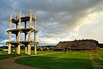
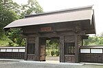
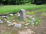
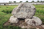
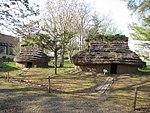
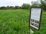
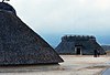
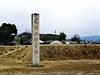
List of Historic Sites of Japan (Aomori)

Last updated

Map all coordinates using: OpenStreetMap  
Download coordinates as: KML

This list is of the Historic Sites of Japan located within the Prefecture of Aomori . [1]

Contents

National Historic Sites

As of 17 December 2021, twenty-three Sites have been designated as being of national significance (including one *Special Historic Site). [2] [3] [4]

SiteMunicipalityCommentsImageCoordinatesTypeRef.
*Sannai-Maruyama Site
三内丸山遺跡
Sannai-Maruyama iseki
Aomori inscribed on the UNESCO World Heritage List as one of the Jōmon Prehistoric Sites in Northern Japan [5]
Sannai-Maruyama Site 140913 Sannai-Maruyama site Aomori Japan01bs6bs6.jpg
Sannai-Maruyama Site
40°48′40″N140°41′55″E / 40.81103046°N 140.69849073°E / 40.81103046; 140.69849073 (Sannai-Maruyama Site) 1 108
Akōbō Kofun Cluster
阿光坊古墳群
Akōbō kofun-gun
Oirase Kofun period tumuli
Akobo Kofun Cluster Akobo Kofunjpg.jpg
Akōbō Kofun Cluster
40°36′34″N141°22′36″E / 40.60932481°N 141.37675044°E / 40.60932481; 141.37675044 (Akōbō Kofun Cluster) 1 00003536
Kamegaoka Stone Age Site
亀ヶ岡石器時代遺跡
Kamegaoka sekki-jidai iseki
Tsugaru inscribed on the UNESCO World Heritage List as one of the Jōmon Prehistoric Sites in Northern Japan [5]
Kamegaoka Stone Age Site Kamegaoka2.jpg
Kamegaoka Stone Age Site
40°53′06″N140°20′22″E / 40.884895°N 140.339569°E / 40.884895; 140.339569 (Kamegaoka Stone Age Site) 1 97
Goshogawara Sue Pottery Kiln Site
五所川原須恵器窯跡
Goshogawara Sue-ki kama ato
Goshogawara Heian period kiln ruins 40°45′31″N140°32′49″E / 40.758636°N 140.546814°E / 40.758636; 140.546814 (Goshogawara Sue Pottery Kiln Site) 6 3397
Takayashikidate Site
高屋敷館遺跡
Takayashikidate iseki
Aomori Heian period settlement ruins 40°44′13″N140°35′04″E / 40.73694142°N 140.58444583°E / 40.73694142; 140.58444583 (Takayashikidate Site) 1 3276
Ne Castle ruins
根城跡
Ne-jō ato
Hachinohe Muromachi period
Ne Castle ruins Nejo-castle01.jpg
Ne Castle ruins
40°30′22″N141°27′39″E / 40.50619217°N 141.46092654°E / 40.50619217; 141.46092654 (Ne Castle ruins) 2 95
Shichinohe Castle ruins
七戸城跡
Shichinohe-jō ato
Shichinohe Muromachi period castle ruins
Shichinohe Castle ruins Qi Hu Cheng Dong Men .JPG
Shichinohe Castle ruins
40°41′52″N141°08′57″E / 40.69766596°N 141.149052°E / 40.69766596; 141.149052 (Shichinohe Castle ruins) 2 96
Tosaminato ruins
十三湊遺跡
Tosa minato iseki
Goshogawara Muromachi period settlement ruins 41°01′43″N140°19′46″E / 41.02849518°N 140.3294933°E / 41.02849518; 140.3294933 (Tosaminato ruins) 1, 2, 6 00003446
Komakino Site
小牧野遺跡
Komakino iseki
Aomori inscribed on the UNESCO World Heritage List as one of the Jōmon Prehistoric Sites in Northern Japan [5]
Komakino Site Xiao Mu Ye Yi Ji 1.jpg
Komakino Site
40°44′19″N141°08′57″E / 40.7385616°N 141.149052°E / 40.7385616; 141.149052 (Komakino Site) 1 107
Tareyanagi Site
垂柳遺跡
Tareyanagi iseki
Inakadate Yayoi period rice paddies [6]
Tareyanagi Site Tareyanagi site.jpg
Tareyanagi Site
40°37′59″N140°33′57″E / 40.63291889°N 140.5659689°E / 40.63291889; 140.5659689 (Tareyanagi Site) 6 3251
Korekawa Site
是川遺跡
Korekawa iseki
Hachinohe ICP excavated artefacts; [7] inscribed on the UNESCO World Heritage List as one of the Jōmon Prehistoric Sites in Northern Japan [5]
Korekawa Site Korekawa Site.jpg
Korekawa Site
40°28′25″N141°29′28″E / 40.473722°N 141.491032°E / 40.473722; 141.491032 (Korekawa Site) 1 101
Shōjujidate Castle ruins
聖寿寺館跡
Shōjujitate ato
Nanbu Muromachi period castle ruins
Shojujitate ruins Shojujidate ruins.jpg
Shōjujitate ruins
40°24′45″N141°15′54″E / 40.41246999°N 141.2651261°E / 40.41246999; 141.2651261 (Shōjujitate ruins) 2 3396
Tangotai Kofun cluster
丹後平古墳群
Tangotai kofun
Hachinohe Kofun period tumuli 40°28′52″N141°28′01″E / 40.48117767°N 141.46694685°E / 40.48117767; 141.46694685 (Tangotai Kofun) 1 3207
Chōshichiyachi Shell Mound
長七谷地貝塚
Chōshichiyachi kaizuka
Hachinohe
Choshichiyachi Shell Mound Choshichiyachi Shell Midden.jpg
Chōshichiyachi Shell Mound
40°34′19″N141°27′32″E / 40.571987°N 141.458878°E / 40.571987; 141.458878 (Chōshichiyachi Shell Mound) 1 106
Tsugaru Clan Castle Sites
津軽氏城跡
Tsugaru-shi shiro ato
Hirosaki, Ajigasawa designation includes the sites of Tanesato Castle, Horikoshi Castle, and Hirosaki Castle (pictured)
Tsuruga clan castles Hirosaki castle nishibori.jpg
Tsuruga clan castles
40°36′27″N140°27′51″E / 40.607371°N 140.464218°E / 40.607371; 140.464218 (Tsuruga clan castles) 2 99
Tagoyano Shell Mound
田小屋野貝塚
Tagoyano kaizuka
Tsugaru site inscribed on the UNESCO World Heritage List as one of the Jōmon Prehistoric Sites in Northern Japan [5]
Tagoyano Shell Mound Tagoyano Shell Mound 03.jpg
Tagoyano Shell Mound
40°53′17″N140°20′21″E / 40.888176°N 140.339233°E / 40.888176; 140.339233 (Tagoyano Shell Mound) 1 98
Futatsumori Site
二ツ森貝塚
Futatsumori kaizuka
Shichinohe inscribed on the UNESCO World Heritage List as one of the Jōmon Prehistoric Sites in Northern Japan [5]
Futatsumori Shell Mound Futatsumori Kaizuka1.jpg
Futatsumori Shell Mound
40°44′54″N141°13′47″E / 40.74845883°N 141.22984087°E / 40.74845883; 141.22984087 (Futatsumori Shell Mound) 1 3206
Hamashiriya Shell Mound
浜尻屋貝塚
Hamashiriya kaizuka
Higashidōri Muromachi period shell middens 41°24′38″N141°27′31″E / 41.41065294°N 141.45849047°E / 41.41065294; 141.45849047 (Hamashiriya Shell Mound) 1 00003495
Namioka Castle ruins
浪岡城跡
Namioka-jō ato
Aomori Muromachi period castle ruins
Namioka Castle ruins Namioka Castle site.jpg
Namioka Castle ruins
40°43′04″N140°36′17″E / 40.71790161°N 140.60476718°E / 40.71790161; 140.60476718 (Namioka Castle ruins) 2 93
Ōmori Katsuyama Site
大森勝山遺跡
Ōmori Katsuyama iseki
Hirosaki Jōmon period stone circle; inscribed on the UNESCO World Heritage List as one of the Jōmon Prehistoric Sites in Northern Japan [5]
Omori Katsuyama Site Omori-Katsuyama Stone Circle.jpg
Ōmori Katsuyama Site
40°36′11″N140°27′50″E / 40.6031025°N 140.46392222°E / 40.6031025; 140.46392222 (Ōmori Katsuyama Site) 1 00003759
Ōdai Yamamoto I Site
大平山元遺跡
Ōdai Yamamoto iseki
Sotogahama inscribed on the UNESCO World Heritage List as one of the Jōmon Prehistoric Sites in Northern Japan [5]
Odai Yamamoto I Site Odai Yamamoto I site (under construction).jpg
Odai Yamamoto I Site
41°04′02″N140°33′18″E / 41.067288°N 140.554973°E / 41.067288; 140.554973 (Odai Yamamoto I Site) 1 00003780
Sannobō Site
山王坊遺跡
Sannobō iseki
Goshogawara Muromachi period temple ruins
Sannobo Site Goshogawara Hiyoshi Jinja torii.jpg
Sannobō Site
41°03′58″N140°22′02″E / 41.06624°N 140.36720°E / 41.06624; 140.36720 (Sannobō Site) 3 00003964
Sannohe Castle Site
三戸城跡
Sannohe-jō ato
Sannohe San Hu Cheng Gang Yu Men .JPG 40°22′52″N141°15′50″E / 40.381101°N 141.263971°E / 40.381101; 141.263971 (Sannohe Castle Site) 2

Prefectural Historic Sites

As of 11 October 2021, a further twenty Sites have been designated as being of prefectural importance. [4] [8]

SiteMunicipalityCommentsImageCoordinatesTypeRef.
Seki Old Stelai
関の古碑群
Seki no ko-hi-gun
Fukaura forty-two C14 memorial stelai 40°44′23″N140°06′14″E / 40.739624°N 140.103997°E / 40.739624; 140.103997 (Seki Old Stelai)
Hachinohe Nanbu clan cemetery
八戸南部家墓所
Hachinohe nanbu-ke bosho
Hachinohe Hachinohe-nanbuke-bosyo.jpg 40°30′10″N141°29′20″E / 40.502860°N 141.488875°E / 40.502860; 141.488875 (Hachinohe Nanbu clan cemetery)
Karauma Stele
唐馬の碑
Karauma no hi
Sannohe 40°23′45″N141°15′50″E / 40.395866°N 141.263988°E / 40.395866; 141.263988 (Karauma Stele)
Tenma Ichirizuka
一里塚
ichirizuka
Hachinohe in Tenma; one mound survives 40°28′33″N141°30′47″E / 40.475885°N 141.513133°E / 40.475885; 141.513133 (Ichirizuka)
Tairakubo Ichirizuka
一里塚
ichirizuka
Towada in Tairakubo; both mounds survive 40°34′29″N141°15′53″E / 40.574620°N 141.264589°E / 40.574620; 141.264589 (Ichirizuka)
Ikenotani Ichirizuka
一里塚
ichirizuka
Towada in Ikenotai; both mounds survive 40°40′34″N141°10′29″E / 40.676098°N 141.174595°E / 40.676098; 141.174595 (Ichirizuka)
Bonozuka Ichirizuka
一里塚
ichirizuka
Noheji in Bonozuka; both mounds survive 40°51′33″N141°07′36″E / 40.859071°N 141.126782°E / 40.859071; 141.126782 (Ichirizuka)
Sotsukozawa Ichirizuka
一里塚
ichirizuka
Shichinohe in Sotsukozawa; both mounds survive 40°47′00″N141°10′21″E / 40.783369°N 141.172385°E / 40.783369; 141.172385 (Ichirizuka)
Morinokami Ichirizuka
一里塚
ichirizuka
Shichinohe in Morinokami; both mounds survive 40°44′45″N141°09′24″E / 40.74581°N 141.156571°E / 40.74581; 141.156571 (Ichirizuka)
Nagakubo Ichirizuka
一里塚
ichirizuka
Hachinohe in Nagakubo; one mound survives 40°26′14″N141°27′48″E / 40.437361°N 141.463330°E / 40.437361; 141.463330 (Ichirizuka)
Shinden Ichirizuka
一里塚
ichirizuka
Hachinohe in Shinden; both mounds survive 40°24′34″N141°26′21″E / 40.409559°N 141.439211°E / 40.409559; 141.439211 (Ichirizuka)
Sunakozaki Ichirizuka
一里塚
ichirizuka
Hachinohe in Sunakozaki; both mounds survive 40°22′36″N141°25′01″E / 40.376579°N 141.416960°E / 40.376579; 141.416960 (Ichirizuka)
Yahatazaki Site
八幡崎遺跡
Yahatazaki iseki
Hirakawa 40°37′03″N140°32′07″E / 40.617463°N 140.5352°E / 40.617463; 140.5352 (Yahatazaki Site)
Hankyōzuka
藩境塚
Hankyōzuka
Hiranai/Noheji four mounds 40°53′14″N141°04′57″E / 40.887108°N 141.082488°E / 40.887108; 141.082488 (Hankyōzuka)
Battle of Noheji cemetery
野辺地戦争戦死者の墓所
Noheji-sensō senshisha no bosho
Noheji Noheiji Battle Memorial.jpg 40°52′16″N141°06′34″E / 40.871181°N 141.109461°E / 40.871181; 141.109461 (Noheji Battle Graves of the Dead)
Nakano Ichirizuka
一里塚
ichirizuka
Sannohe in Nakano; both mounds survive 40°21′01″N141°15′43″E / 40.350354°N 141.261992°E / 40.350354; 141.261992 (Ichirizuka)
Tonai Mass Graves and Memorial Stele
斗内千人塚 墳丘 供養塔
Tonai senninzuka funkyū kuyōtō
Sannohe from the great famine of 1783-4 (天明の大飢饉) 40°21′34″N141°12′25″E / 40.359573°N 141.206919°E / 40.359573; 141.206919 (Tonai Mass Graves and Memorial Stele)
Memorial Stele and Platform for the Starved
餓死萬霊等供養塔及び戒壇石
Gashi banrei-tō kuyōtō oyobi kaidanseki
Hachinohe from the 1780s famine; in Teranoue 40°29′55″N141°31′35″E / 40.498594°N 141.526415°E / 40.498594; 141.526415 (Memorial Stele and Platform for the Starved)
Nakasato Castle ruins
中里城遺跡
Nakasato-jō iseki
Nakadomari 40°58′13″N140°26′30″E / 40.970210°N 140.441666°E / 40.970210; 140.441666 (Nakasato Castle Site)
Tairadate Battery ruins
平舘台場跡
Tairadate daiba ato
Sotogahama 41°10′28″N140°38′34″E / 41.174572°N 140.642724°E / 41.174572; 140.642724 (Tairadate Battery Site)

Municipal Historic Sites

As of 1 May 2021, a further ninety-two Sites have been designated as being of municipal importance. [9]

See also

References

  1. "Cultural Properties for Future Generations". Agency for Cultural Affairs . Retrieved 28 December 2021.
  2. 史跡名勝天然記念物 [Number of Monuments of Japan by Prefecture] (in Japanese). Agency for Cultural Affairs. 1 December 2021. Retrieved 28 December 2021.
  3. "Database of National Cultural Properties: 史跡名勝天然記念物 (史跡, 特別史跡 青森県)" (in Japanese). Agency for Cultural Affairs . Retrieved 28 December 2021.
  4. 1 2 国・県指定文化財一覧 [List of National and Prefectural Cultural Properties] (in Japanese). Aomori Prefecture. 11 October 2021. Retrieved 28 December 2021.
  5. 1 2 3 4 5 6 7 8 "Jomon Prehistoric Sites in Northern Japan". UNESCO . Retrieved 28 December 2021.
  6. 垂柳遺跡 [Tareyanagi Site] (in Japanese). Aomori Prefecture . Retrieved 13 June 2012.
  7. 陸奥国是川遺跡出土品 [Excavated Artifacts from the Korekawa Site] (in Japanese). Agency for Cultural Affairs . Retrieved 13 June 2012.
  8. 都道府県別指定等文化財件数(都道府県分) [Number of Prefectural Cultural Properties by Prefecture] (in Japanese). Agency for Cultural Affairs. 1 May 2021. Retrieved 28 December 2021.
  9. 都道府県別指定等文化財件数(市町村分) [Number of Municipal Cultural Properties by Prefecture] (in Japanese). Agency for Cultural Affairs. 1 May 2021. Retrieved 28 December 2021.