Aomori Prefecture is a prefecture of Japan in the Tōhoku region. The prefecture's capital, largest city, and namesake is the city of Aomori. Aomori is the northernmost prefecture on Japan's main island, Honshu, and is bordered by the Pacific Ocean to the east, Iwate Prefecture to the southeast, Akita Prefecture to the southwest, the Sea of Japan to the west, and Hokkaido across the Tsugaru Strait to the north. Aomori Prefecture is the 8th-largest prefecture, with an area of 9,645.64 km2 (3,724.20 sq mi), and the 31st-most populous prefecture, with more than 1.2 million people. Approximately 45 percent of Aomori Prefecture's residents live in its two core cities, Aomori and Hachinohe, which lie on coastal plains. The majority of the prefecture is covered in forested mountain ranges, with population centers occupying valleys and plains. Aomori is the third-most populous prefecture in the Tōhoku region, after Miyagi Prefecture and Fukushima Prefecture. Mount Iwaki, an active stratovolcano, is the prefecture's highest point, at almost 1,624.7 m (5,330 ft).

Towada is a city in Aomori Prefecture, Japan. As of 31 March 2020, the city had an estimated population of 60,697, and a population density of 84 persons per km2 in 27,677 households. The total area of the city is 725.65 square kilometers (280.18 sq mi).
Shingō is a village located in Aomori Prefecture, Japan. As of 31 March 2020, the village has an estimated population of 2,408 in 922 households and a population density of 16 persons per km². The total area of the village is 150.77 square kilometres (58.21 sq mi).
Towadako was a town located in Kamikita District in central Aomori Prefecture, Japan.
Rokunohe is a town located in Aomori Prefecture, Japan. As of 31 March 2020, the town had an estimated population of 10,994, and a population density of 130 persons per km², in 4,419 households. The total area of the town is 83.89 square kilometres (32.39 sq mi)
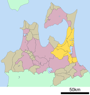
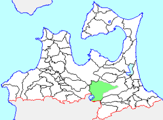
Kamikita District is a district located in Aomori Prefecture, Japan. It occupies the east-central portion of the prefecture, south of Shimokita Peninsula.

Gonohe is a town located in Aomori Prefecture, Japan. As of 1 April 2020, the town had an estimated population of 16,880, and a population density of 95 persons per km2 in 7,006 households. The total area of the town is 177.67 square kilometres (68.60 sq mi).
Lake Towada is the largest crater lake in Honshū island, Japan. Located on the border between Aomori and Akita prefectures, it lies 400 meters (1,800 ft) above sea level and is 327 m (1,073 ft) deep, drained by the Oirase river. With a surface area of 61.1 km², Towada is Japan's 12th largest lake, its bright blue color is due to its great depth. The lake is roughly circular, with two peninsulas extending from its southern shore approximately one-third into the center of the lake. The lake is a popular tourist destination.
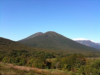
The Hakkōda Mountains are an active volcanic complex in south-central Aomori Prefecture, Japan, in Towada-Hachimantai National Park. Often called Mount Hakkōda or simply Hakkōda (八甲田), the mountains are collectively listed as one of the 100 Famous Japanese Mountains. Its highest peak, Mount Ōdake, lies 21.3 kilometers (13.2 mi) southeast of central Aomori and 28 kilometers (17 mi) west of central Towada and has an elevation of 1,585 meters (5,200 ft). The Hakkōda Mountains are a part Ōu Mountains which make up part of the Northeastern Japan Arc, a segment of the Pacific Ring of Fire. The volcanic complex consists of fourteen stratovolcanoes and lava domes arranged into two volcanic groups. The Northern Hakkōda Volcanic Group emerges from the rim of an 8-kilometer-wide (5.0 mi) caldera that dates back to the Pleistocene. The Southern Hakkōda Volcanic Group predates the caldera.

Shimoda Station is a railway station on the Aoimori Railway Line in the town of Oirase in Aomori Prefecture, Japan, operated by the third sector railway operator Aoimori Railway Company.

Towada-Hachimantai National Park is a national park comprising two separate areas of Aomori, Iwate, and Akita Prefectures, Japan. The Towada-Hakkōda area encompasses Lake Towada, Mount Hakkōda, and most of the Oirase River valley. The Hachimantai area includes Mount Hachimantai, Mount Iwate, Tamagawa Onsen, and Akita Komagatake. The two areas are 50 kilometres (31 mi) apart, and cover 854 square kilometres (330 sq mi).
Oirase is a town located in Aomori Prefecture, Japan. As of 31 March 2020, the town had an estimated population of 25,149, and a population density of 350 persons per km², in 10,423 households. The total area of the town is 71.96 square kilometres (27.78 sq mi).
National Route 102 is a national highway in the Japanese prefecture of Aomori. Route 102 stretches 102.8 kilometers (63.9 mi) from National Route 7 in Hirosaki east to National Routes 4 and 45 in Towada.
National Route 103 is a national highway of Japan connecting the capital of Aomori Prefecture, Aomori to Ōdate in northeastern Akita Prefecture. It has a total length of 130.0 km (80.8 mi).
National Route 454 is a national highway of Japan that traverses southern Aomori Prefecture and briefly crosses into the northeastern edge of Akita before returning in to Aomori. It connects Hachinohe in eastern Aomori to Ōwani in the western part of the prefecture.

The Iwaki River is a river that crosses western Aomori Prefecture, Japan. It is 102 kilometers (63 mi) in length and has a drainage area of 2,544 square kilometers (982 sq mi). Under the Rivers Act of 1964 the Iwaki is designated as a Class 1 River and is managed by the Japanese Ministry of Land, Infrastructure, Transport and Tourism. The Iwaki River is the longest river in Aomori Prefecture, and is the source of irrigation for the large-scale rice and apple production of the prefecture. The Iwaki River, in the Tōhoku region north of the Fukushima Daiichi Nuclear Power Plant, remains unpolluted by radioactive materials after the Fukushima Daiichi nuclear disaster. Testing for caesium-134 and caesium-137 is carried out and published on a bimonthly basis.

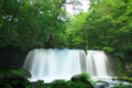
Matsumi Falls is a waterfall in the city of Towada, Aomori Prefecture, Japan, on a tributary of the Oirase River, which flows down from Lake Towada. It is one of "Japan’s Top 100 Waterfalls", in a listing published by the Japanese Ministry of the Environment in 1990.